|
|
 |
|

|
|
|
An SAR and optical image fusion algorithm coupling non-local self-similarity and divergence |
FU Yukai1( ), YANG Shuwen1,2,3(), YAN Heng1, XUE Qing1, HONG Weili1, SU Hang1 ), YANG Shuwen1,2,3(), YAN Heng1, XUE Qing1, HONG Weili1, SU Hang1 |
1. Faculty of Geomatics, Lanzhou Jiaotong University, Lanzhou 730070, China
2. National-Local Joint Engineering Research Center of Technologies and Applications for National Geographic State Monitoring, Lanzhou 730070, China
3. Gansu Provincial Engineering Laboratory for National Geographic State Monitoring, Lanzhou 730070, China |
|
|
|
|
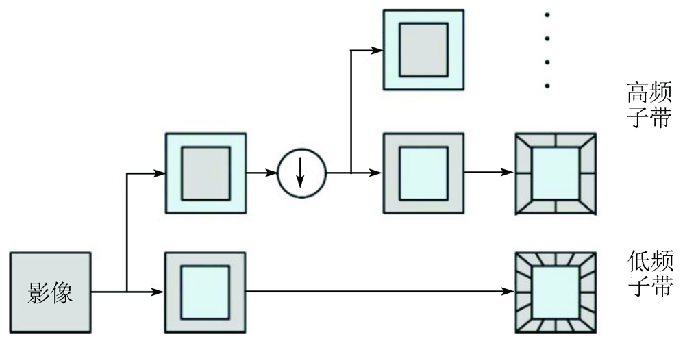
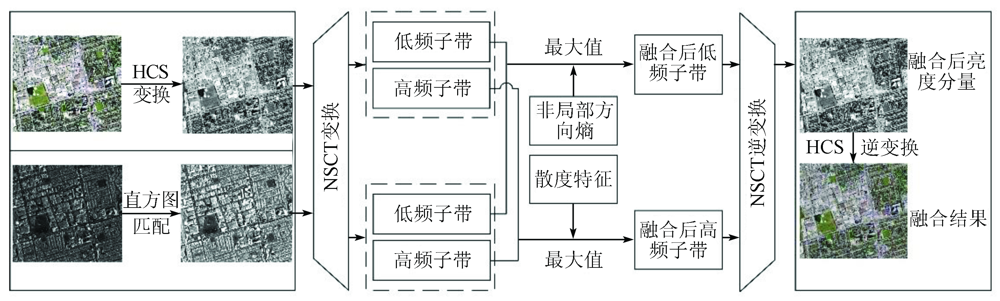
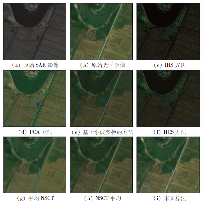
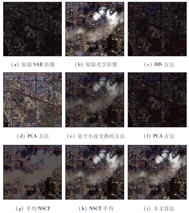
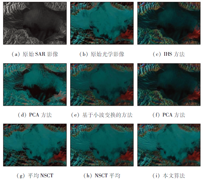
Abstract Currently, the high-quality fusion of SAR and optical images is a hot research topic. However, the significant radiation difference and weak gray correlation between SAR and optical images greatly reduce the fusion quality. In this regard, this study proposed a SAR and optical remote sensing image fusion algorithm that coupled non-local self-similarity and divergence. First, images were decomposed in the frequency domain. Then, the non-local directional entropy and divergence were used as characteristic parameters to guide the fusion of low- and high-frequency components, respectively. Finally, the fusion components were reconstructed to obtain fusion images with clear structural features and rich spectral information. The comparative experiments verified the effectiveness of the proposed algorithm in fusing SAR with optical images and its superiority in maintaining structural features and reducing spectral distortion.
|
| Keywords
SAR and optical image
non-subsampled contourlet transform
global feature
image fusion
hyper-spherical color space
|
|
|
|
Issue Date: 20 March 2023
|
|
|
| [1] |
王梦瑶, 孟祥超, 邵枫, 等. 基于深度学习的SAR辅助下光学遥感图像去云方法[J]. 光学学报, 2021, 41(12):243-251.
|
| [1] |
Wang M Y, Meng X C, Shao F, et al. SAR-assisted optical remote sensing image cloud removal method based on deep learning[J]. Acta Optica Sinica, 2021, 41(12):243-251.
|
| [2] |
李卫国, 蒋楠, 熊世为. 基于ARSIS策略的SAR影像与多光谱遥感小波融合[J]. 农业工程学报, 2012, 28(s1):158-163.
|
| [2] |
Li W G, Jiang N, Xiong S W. Multi-spectral and SAR wavelet fusion based on ARSIS strategy[J]. Transactions of the Chinese Society of Agricultural Engineering, 2012, 28(s1):158-163.
|
| [3] |
陈东, 李飚, 沈振康. SAR与可见光图像融合算法的研究[J]. 系统工程与电子技术, 2000(9):5-7,43.
|
| [3] |
Chen D, Li B, Shen Z K. Research on data fusion algorithm of SAR and optical images[J]. Systems Engineering and Electronics, 2000(9):5-7,43.
|
| [4] |
徐赣, 尤红建. 小波的SAR和光学图像融合方法比较研究[J]. 测绘科学, 2008(1):109-112,249.
|
| [4] |
Xu G, You H J. Comparative study on wavelet-based SAR and optical image fusion methods[J]. Science of Surveying and Mapping, 2008(1):109-112,249.
|
| [5] |
李晖晖, 郭雷, 李国新. 基于脊波变换的SAR与可见光图像融合研究[J]. 西北工业大学学报, 2006(4):418-422.
|
| [5] |
Li H H, Guo L, Li G X. Is Ridgelet transform better than wavelet transform in SAR and optical image fusion[J]. Journal of Northwestern Polytechnical University, 2006(4):418-422.
|
| [6] |
高文涛, 汪小钦, 凌飞龙, 等. 基于纹理的雷达与多光谱遥感数据小波融合研究[J]. 中国图象图形学报, 2008(7):1341-1346.
|
| [6] |
Gao W T, Wang X Q, Ling F L, et al. Fusion algorithm research based on texture for SAR and multispectral images with wavelet transform[J]. Journal of Image and Graphics, 2008(7):1341-1346.
|
| [7] |
Anandhi D, Valli S. An algorithm for multi-sensor image fusion using maximum a posteriori and nonsubsampled contourlet transform[J]. Computers and Electrical Engineering, 2018, 65(1):139-152.
doi: 10.1016/j.compeleceng.2017.04.002
url: https://linkinghub.elsevier.com/retrieve/pii/S0045790617307826
|
| [8] |
易维, 曾湧, 原征. 基于NSCT变换的高分三号SAR与光学图像融合[J]. 光学学报, 2018, 38(11):76-85.
|
| [8] |
Yi W, Zeng Y, Yuan Z. Fusion of GF-3 SAR and optical images based on the nonsubsampled contourlet transform[J]. Acta Optica Sinica, 2018, 38(11):76-85.
|
| [9] |
李小军, 闫浩文, 杨树文, 等. 一种多光谱遥感影像与航拍影像融合算法[J]. 遥感信息, 2019, 34(4):11-15.
|
| [9] |
Li X J, Yan H W, Yang S W, et al. A fusion algorithm of multispectral remote sensing image and aerial image[J]. Remote Sensing Information, 2019, 34(4):11-15.
|
| [10] |
Padwick C, Deskevich M, Pacifici F, et al. WorldView-2 pan-sharpening[C]// Proceedings of the ASPRS 2010 Annual Conference,San Diego,CA,USA. 2010, 2630:1-14.
|
| [11] |
Chong X J. Comparative analysis of different fusion rules for SAR and multispectral image fusion based on NSCT and IHS transform[C]// International Conference on Computer and Computational Sciences(ICCCS),IEEE: 2015,271-274.
|
| [12] |
Maryam G, Mohammad S H, Habibollah D. Nonsubsampled contourlet transform-based conditional random field for SAR images segmentation[J]. Signal Processing, 2020, 174(9):107623.
doi: 10.1016/j.sigpro.2020.107623
url: https://linkinghub.elsevier.com/retrieve/pii/S0165168420301663
|
| [13] |
卜丽静, 赵爽, 张正鹏. NLM与比率图像的多时相SAR图像去噪方法[J]. 遥感信息, 2021, 36(3):17-24.
|
| [13] |
Pu L J, Zhao S, Zhang Z P. A multi-temporal SAR image denoising method based on NLM and ratio image[J]. Remote Sensing Information, 2021, 36(3):17-24.
|
| [14] |
胡学敏, 余进, 邓重阳, 等. 基于时空立方体的人群异常行为检测与定位[J]. 武汉大学学报(信息科学版), 2019, 44(10):1530-1537.
|
| [14] |
Hu X M, Yu J, Deng C Y, et al. Abnormal crowd behavior detection and location based on spatial-temporal cube[J]. Geomatics and Information Science of Wuhan University, 2019, 44(10):1530-1537.
|
| [15] |
Samadhan C, Kulkarni,Priti P.Rege,Pixel level fusion techniques for SAR and optical images:A review[J]. Information Fusion (2020), doi:https://doi.org/10.1016/j.inffus.2020.01.003.
doi: https://doi.org/10.1016/j.inffus.2020.01.003
|
| [16] |
郑胜, 田岩, 柳健, 等. 基于散度的不同焦点图像融合方法[J]. 华中科技大学学报(自然科学版), 2007(4):7-10.
|
| [16] |
Zheng S, Tian Y, Liu J, et al. Divergence-based multifocuses image fusion[J]. Journal of Huazhong University of Science and Technology(Natural Science Edition), 2007(4):7-10.
|
| [17] |
尹峰, 孟祥超, 梁鹏. 一种国产高分卫星遥感影像变分融合方法[J]. 国土资源遥感, 2018, 30(2):100-106.doi:10.6046/gtzyyg.2018.02.14.
doi: 10.6046/gtzyyg.2018.02.14
|
| [17] |
Yin F, Meng X C, Liang P. A variational fusion method for remote sensing images of China’s domestic high-resolution satellites[J]. Remote Sensing for Land and Resources, 2018, 30(2):100-106.doi:10.6046/gtzyyg.2018.02.14.
doi: 10.6046/gtzyyg.2018.02.14
|
| [18] |
Lichun S, Jonathan L. Fusion of hyperspectral and multispectral images based on a Bayesian nonparametric approach[J]. IEEE Journal of Selected Topics in Applied Earth Observations and Remote Sensing, 2019, 12(2):1205-1218.
doi: 10.1109/JSTARS.4609443
url: https://ieeexplore.ieee.org/xpl/RecentIssue.jsp?punumber=4609443
|
| [19] |
Zhang Q, Maldague X. An adaptive fusion approach for infrared and visible images based on NSCT and compressed sensing[J]. Infrared Physics & Technology, 2016, 74(1):11-20.
|
| [20] |
Li X J, Yan H W, Xie W Y, et al. An improved pulse-coupled neural network model for pan sharpening[J]. Sensors, 2020, 20(13),2764.
|
| [21] |
Tu T M, Su S C, Syu H C, et al. A new look at HIS like image fusion methods[J]. Information Fusion, 2001, 2(3):177-186.
doi: 10.1016/S1566-2535(01)00036-7
url: https://linkinghub.elsevier.com/retrieve/pii/S1566253501000367
|
| [22] |
Psjr C, Sides S C, Anderson J A. Comparison of three different methods to merge multiresolution and multispectral data:Landsat TM and SPOT panchromatic[J]. Photogrammetric Engineering & Remote Sensing, 1991, 57(3):256-303.
|
| [23] |
Hong G, Zhang Y, Mercer B. A wavelet and HIS integration method to fuse high resolution sar with moderate resolution multispectral images[J]. Photogrammetric Engineering & Remote Sensing, 2009, 75(10):1213-1223.
|
|
Viewed |
|
|
|
Full text
|
|
|
|
|
Abstract
|
|
|
|
|
Cited |
|
|
|
|
| |
Shared |
|
|
|
|
| |
Discussed |
|
|
|
|
 2023,
Vol. 35
2023,
Vol. 35