|
|
 |
|

|
|
|
A study of temperature distribution in the sea area around Qinshan Nuclear Power Plant based on satellite remote sensing |
SHI Haigang1,2( ), LIANG Chunli1,2(), XUE Qing1,2, ZHANG En1,2, ZHANG Xinyi1,2, ZHANG Jianyong1,2, ZHANG Chunlei1, CHENG Xu1,2 ), LIANG Chunli1,2(), XUE Qing1,2, ZHANG En1,2, ZHANG Xinyi1,2, ZHANG Jianyong1,2, ZHANG Chunlei1, CHENG Xu1,2 |
1. Airborne Survey and Remote Sensing Center of Nuclear Industry, Shijiazhuang 050002, China
2. Hebei Key Laboratory of Airborne Survey and Remote Sensing Technology, Shijiazhuang 050002, China |
|
|
|
|
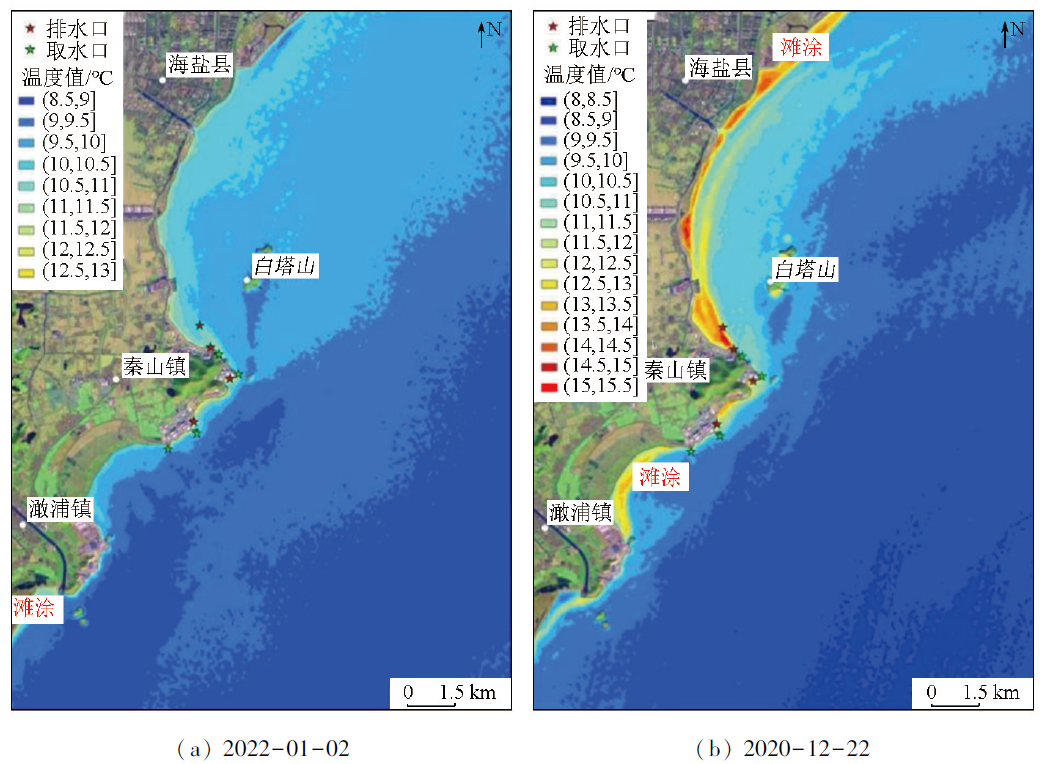
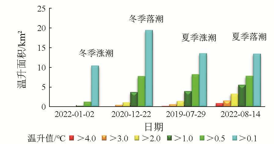
Abstract This study investigated the temperature distribution in the sea area around the Qinshan Nuclear Power Plant using Landsat thermal infrared remote sensing data. The results indicate a strong correlation between the inversion results of temperature and the measured data, suggesting reliable inversion results. Before the operation of the nuclear power plant, the surrounding sea area exhibited relatively uniform temperature, with no significant temperature difference except for natural warming. Furthermore, the temperature along the coast remained almost unchanged in the north-south direction and displayed slight temperature gradients in the east-west direction, with temperature variation not exceeding 0.6 ℃ within 10 km from the coast. After the operation of the nuclear power, the surrounding sea area showed temperature differentiation. The distribution characteristic of thermal discharge was closely related to tides and seasons. In the same season, the increased amplitude of the temperature during ebb tides generally exceeded that during flood tide. Under the same tidal condition, the increased amplitude of the temperature in summer typically exceeded that in winter. At a certain water intake of the first plant, the surface seawater manifested a temperature rise of over 1.0 ℃ during flood tide. Landsat data generally meet the demand for research on temperature distribution in the surrounding sea area of the Qinshan Nuclear Power Plant, and the distribution of thermal discharge under specific tidal conditions can be investigated using aerial remote sensing monitoring.
|
| Keywords
Qinshan Nuclear Power Plant
thermal discharge
temperature inversion
remote sensing monitoring
tide
|
|
|
|
Issue Date: 17 February 2025
|
|
|
| [1] |
高宁, 韩瑞, 赵懿珺, 等. 基于减缓温排水热影响的滨海核电排水明渠改造优化研究[J]. 给水排水, 2022, 58(10):109-115.
|
| [1] |
Gao N, Han R, Zhao Y J, et al. Research on the optimization and modification about the water discharge channel of a coastal NPP based on mitigating the heat effects of its thermal effluent[J]. Water and Wastewater Engineering, 2022, 58(10):109-115.
|
| [2] |
刘永叶, 陈晓秋. 核电厂温排水热影响研究的建议[J]. 辐射防护通讯, 2011, 31(6):20-23.
|
| [2] |
Liu Y Y, Chen X Q. Suggestion of the study on thermal impact of thermal discharge from NPPs[J]. Radiation Protection Bulletin, 2011, 31(6):20-23.
|
| [3] |
陈晓秋, 商照荣. 核电厂环境影响审查中的温排水问题[J]. 核安全, 2007, 6(2):46-50.
|
| [3] |
Chen X Q, Shang Z R. The issue of thermal discharge in reviewing the environmental impacts report for nuclear power plant[J]. Nuclear Safety, 2007, 6(2):46-50.
|
| [4] |
张建永, 梁春利, 石海岗, 等. 热红外遥感技术在核电站温排水监测中的应用[J]. 铀矿地质, 2021, 37(3):534-540.
|
| [4] |
Zhang J Y, Liang C L, Shi H G, et al. Application of thermal infrared remote sensing in monitoring heated water discharge of nuclear power plant[J]. Uranium Geology, 2021, 37 (3):534-540.
|
| [5] |
王虎. 基于卫星热红外数据的田湾核电温排水监测[J]. 地理空间信息, 2022, 20(5):48-53.
|
| [5] |
Wang H. Thermal discharge monitoring of Tianwan nuclear power plant based on satellite thermal infrared data[J]. Geospatial Information, 2022, 20(5):48-53.
|
| [6] |
董双发, 范晓, 石海岗, 等. 基于Landsat8和无人机的福清核电温排水分布研究[J]. 自然资源遥感, 2022, 34(3):112-120.doi:10.6049/zrzyyg.2021258.
|
| [6] |
Dong S F, Fan X, Shi H G, et al. Study on distribution of thermal discharge in Fuqing nuclear power plant based on Landsat8 and UAV[J]. Remote Sensing for Natural Resources, 2022, 34 (3):112-120.doi:10.6049/zrzyyg.2021258.
|
| [7] |
秦山核电厂扩建项目(方家山核电工程)温排水数模计算和分析报告[R]. 浙江省水利河口研究院, 2014.
|
| [7] |
Thermal discharge enumerical simulation calculation and analysis report of Qinshan nuclear power plant expansion project (Fangjia-shan nuclear power project)[R].Zhejiang Institute of Hydraulics and Estuary, 2014.
|
| [8] |
Barsi J A, Barker J L, Schott J R. An atmospheric correction para-meter calculator for a single thermal band earth-sensing instrument[C]// IGARSS 2003—2003 IEEE International Geoscience and Remote Sensing Symposium. IEEE,2005: 3014-3016.
|
| [9] |
Barsi J A, Schott J R, Palluconi F D, et al. Validation of a web-based atmospheric correction tool for single thermal band instruments[C]. Earth Observing Systems X, 2005,5882: 1-6.
|
| [10] |
Jiménez-Muñoz J C, Sobrino J A. A generalized single-channel method for retrieving land surface temperature from remote sensing data[J]. Journal of Geophysical Research:Atmospheres, 2003, 108(D22):4688.
|
| [11] |
Qin Z H, Karnieli A, Berliner P. A mono-window algorithm for retrieving land surface temperature from Landsat TM data and its application to the Israel-Egypt border region[J]. International Journal of Remote Sensing, 2001, 22(18):3719-3746.
|
| [12] |
覃志豪, Zhang M H, Karnieli A, 等. 用陆地卫星TM6数据演算地表温度的单窗算法[J]. 地理学报, 2001, 56(4): 456-466.
doi: 10.11821/xb200104009
|
| [12] |
Qin Z H, Zhang M H, Karnieli A, et al. Mono-window algorithm for retrieving land surface temperature from Landsat TM6 data[J]. Acta Geographica Sinica, 2001, 56(4):456-466.
doi: 10.11821/xb200104009
|
| [13] |
涂梨平, 周斌. 利用Landsat/TM热红外数据进行陆面温度反演的比较[J]. 科技通报, 2007, 23(3):326-331.
|
| [13] |
Tu L P, Zhou B. A comparative study of algorithms for estimating land surface temperature from Landsat/TM data[J]. Bulletin of Science and Technology, 2007, 23(3):326-331.
|
| [14] |
陈望. 温排水效应对秦山核电厂1号机组的影响及应对措施[J]. 中国核电, 2021, 14(1):114-119.
|
| [14] |
Chen W. Influence of warm water discharge on Qinshan nuclear power plant and its countermeasures[J]. China Nuclear Power, 2021, 14(1):114-119.
|
| [15] |
王冠琳, 熊学军. 田湾海域温排水分布及变化规律分析[J]. 海洋科学进展, 2013, 31(1):69-74.
|
| [15] |
Wang G L, Xiong X J. Distribution and variation of warm water discharge in the coastal area of Tianwan[J]. Advances in Marine Science, 2013, 31(1):69-74.
|
| [16] |
朱利, 王桥, 吴传庆, 等. 温排水遥感监测原理与示范[M]. 北京: 中国环境出版社,2016:147-154.
|
| [16] |
Zhu L, Wang Q, Wu C Q, et al. Principle and application of thermal discharge monitoring using remote sensing[M]. Beijing: China Environmental Science Press,2016:147-154.
|
| [17] |
石海岗, 梁春利, 张建永, 等. 岸线变迁对田湾核电站温排水影响遥感调查[J]. 国土资源遥感, 2020, 32(2):196-203.doi:10.6049/gtzyyg.2020.02.25.
|
| [17] |
Shi H G, Liang C L, Zhang J Y, et al. Remote sensing survey of the influence of coastline changes on the thermal discharge in the vi-cinity of Tianwan nuclear power station[J]. Remote Sensing for Land and Resources, 2020, 32(2):196-203.doi:10.6049/gtzyyg.2020.02.25.
|
| [18] |
黄赛花, 章琪宇, 严军, 等. 杭州湾围垦工程引起的岸线变化对水环境的影响分析[J]. 华北水利水电大学学报(自然科学版), 2021, 42(2):32-41.
|
| [18] |
Huang S H, Zhang Q Y, Yan J, et al. Impact of shoreline changes caused by Hangzhou Bay reclamation project on water environment[J]. Journal of North China University of Water Resources and Electric Power (Natural Science Edition), 2021, 42(2):32-41.
|
| [19] |
王力彦, 邢喆, 侯辰, 等. 1990—2017年杭州湾大陆岸线时空变迁分析[J]. 海洋通报, 2020, 39(4):481-487.
|
| [19] |
Wang L Y, Xing Z, Hou C, et al. The spatio-temporal change ana-lysis of mainland coastline in Hangzhou Bay from 1990 to 2017[J]. Marine Science Bulletin, 2020, 39(4):481-487.
|
| [20] |
贺佳惠, 梁春利, 李名松. 核电站近岸温度场航空热红外遥感测量数据处理研究[J]. 国土资源遥感, 2010, 22(3):51-53.doi:10.6046/gtzyyg.2010.03.11.
|
| [20] |
He J H, Liang C L, Li M S. Temperature field airborne thermal remote sensing survey of the alongshore nuclear power station[J]. Remote Sensing for Land and Resources, 2010, 22(3):51-53.doi:10.6046/gtzyyg.2010.03.11.
|
| [21] |
王祥, 王新新, 苏岫, 等. 无人机平台航空遥感监测核电站温排水——以辽宁省红沿河核电站为例[J]. 国土资源遥感, 2018, 30(4):182-186.doi:10.6046/gtzyyg.2018.04.27.
|
| [21] |
Wang X, Wang X X, Su X, et al. Thermal discharge monitoring of nuclear power plant with aerial remote sensing technology using a UAV platform:Take Hongyanhe nuclear power plant,Liaoning Province,as example[J]. Remote Sensing for Land and Resources, 2018, 30(4):182-186.doi:10.6046/gtzyyg.2018.04.27.
|
|
Viewed |
|
|
|
Full text
|
|
|
|
|
Abstract
|
|
|
|
|
Cited |
|
|
|
|
| |
Shared |
|
|
|
|
| |
Discussed |
|
|
|
|
 2025,
Vol. 37
2025,
Vol. 37