|
|
|
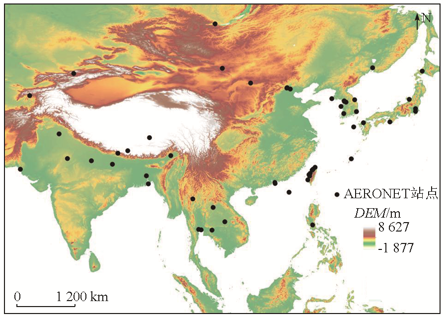
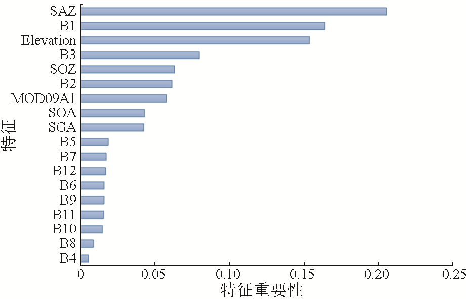
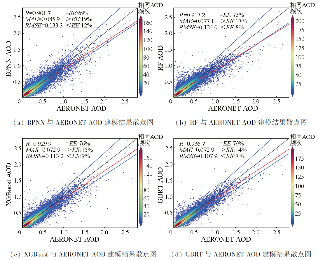
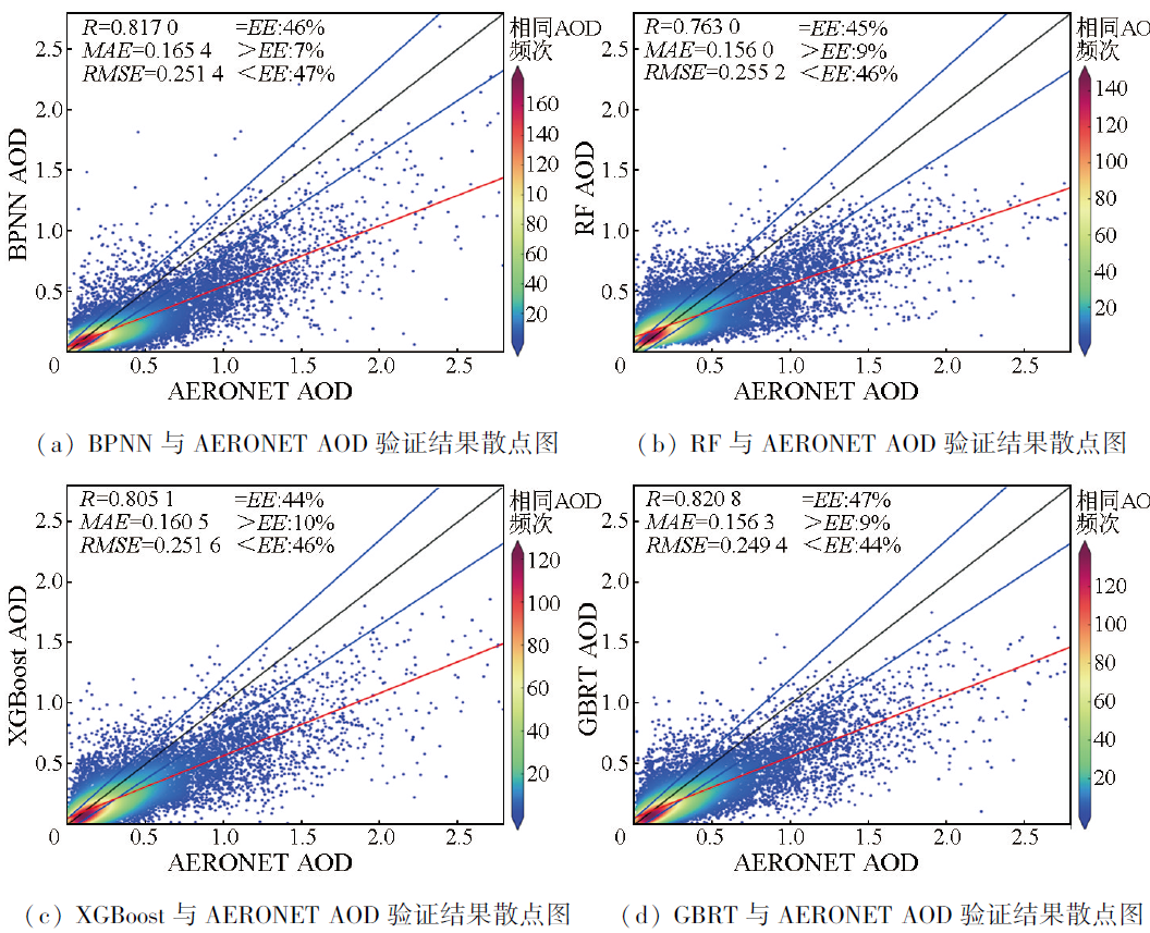
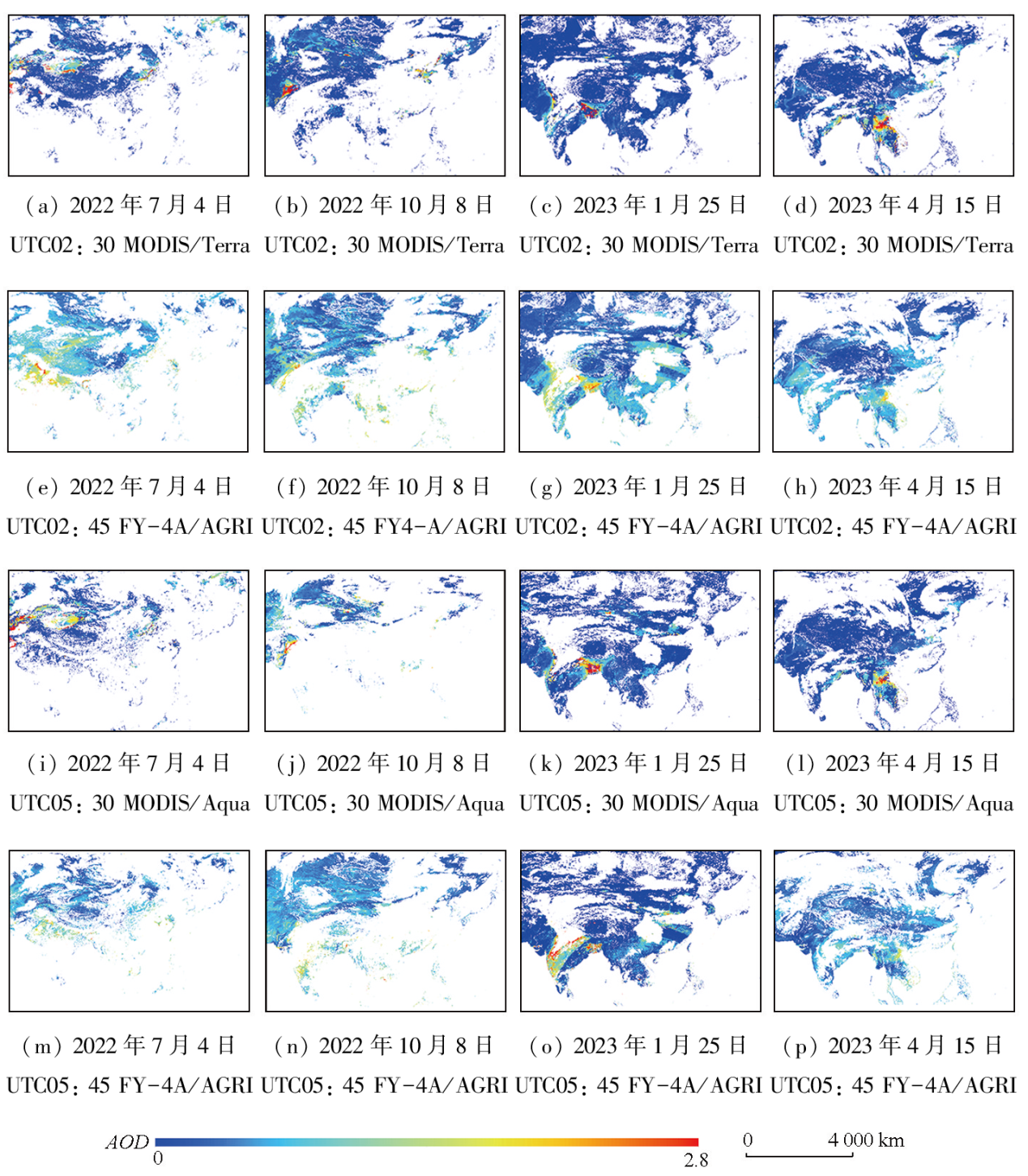
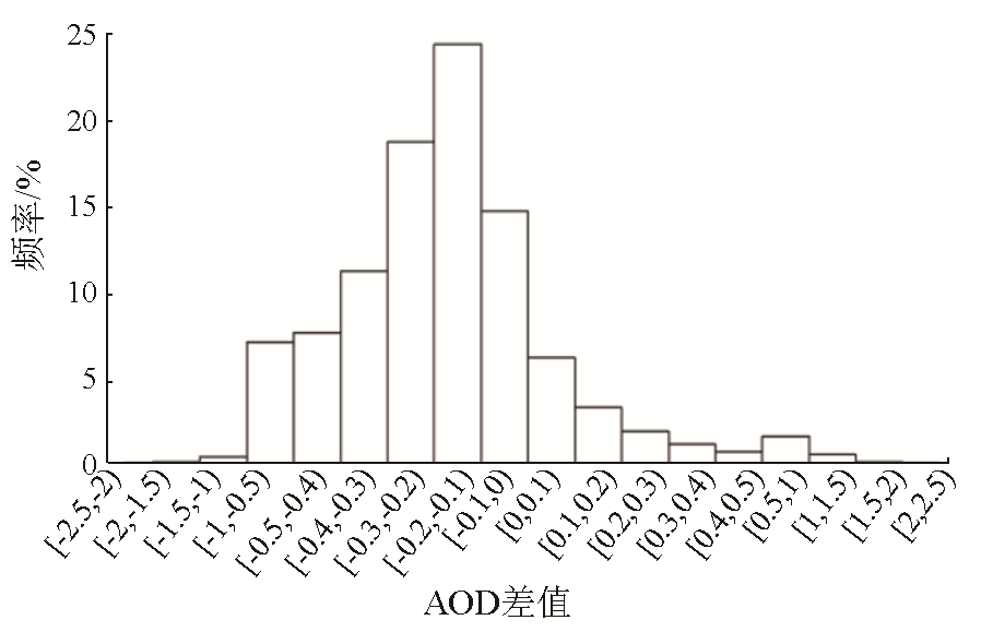
Abstract This study aims to develop a machine learning algorithm based on the characteristics of AGRI data to generate an aerosol dataset with a high spatiotemporal resolution. Using aerosol data from 67 aerosol robotic network (AERONET) sites in China and its surrounding areas in 2021, this study selected data of factors such as apparent reflectance, observation angles, elevation, and MODIS surface reflectance acquired from FY-4A advanced geostationary radiation imager (AGRI)-a new generation geostationary meteorological satellite of China. Then, this study performed the inversion of aerosol optical depth (AOD) using four machine learning methods-random forest (RF), gradient boosting regression tree (GBRT), extreme gradient boosting (XGBoost), and back propagation neural network (BPNN). Using the optimal model determined based on evaluation metrics, this study achieved the AOD inversion with a spatial resolution of 4 km × 4 km based on FY-4A data. Then, this study compared the inversion results with MODIS aerosol products of roughly the same periods. The results indicate that the AOD inversion models based on the four machine learning algorithms yielded correlation coefficients (R) exceeding 0.90, mean absolute errors (MAEs) of less than 0.09, and root mean square errors (RMSE) below 0.14. This indicates that it is feasible to conduct AOD inversion using machine learning-based models. The GBRT-based model exhibited the highest inversion accuracy among the four methods, with a correlation coefficient of 0.82, MAE of 0.16, and RMSE of 0.25, as indicated by the verification results. Additionally, 47% of the inversion results fell within the expected error ranges, indicating that the results of AOD inversion from FY-4A data using the GBRT-based model were generally consistent with observed values. The comparison between the GBRT model-derived AOD inversion results and the results of MODIS aerosol products shows that the former exhibited high consistency with the latter in terms of spatial distribution, with 83.57% of grid deviations falling within the range from -1.0 to 0 and the former slightly higher than the latter.
|
| Keywords
machine learning
AOD
FY-4A/AGRI
AERONET
MODIS AOD
|
|
|
|
Issue Date: 17 February 2025
|
|
|
| [1] |
Mishra M K, Rathore P S, Misra A, et al. Atmospheric correction of multispectral VNIR remote sensing data:Algorithm and inter-sensor comparison ofAerosol and surface reflectance products[J]. Earth and Space Science, 2020, 7(9):e2019EA000710.
|
| [2] |
Xie Y, Xue Y, Guang J, et al. Deriving a global and hourly data set of aerosol optical depth over land using data from four geostationary satellites:GOES-16,MSG-1,MSG-4,and himawari-8[J]. IEEE Transactions on Geoscience and Remote Sensing, 2020, 58(3):1538-1549.
|
| [3] |
Sosnowski T R. Aerosols and human health:A multiscale problem[J]. Chemical Engineering Science, 2023,268:118407.
|
| [4] |
Kaufman Y J, Wald A E, Remer L A, et al. The MODIS 2.1-/ spl mu/m channel-correlation with visible reflectance for use in remote sensing of aerosol[J]. IEEE Transactions on Geoscience and Remote Sensing, 1997, 35(5):1286-1298.
|
| [5] |
Levy R C, Remer L A, Mattoo S, et al. Second-generation operational algorithm:Retrieval of aerosol properties over land from inversion of Moderate Resolution Imaging Spectroradiometer spectral reflectance[J]. Journal of Geophysical Research:Atmospheres, 2007, 112(D13):211-231.
|
| [6] |
Hsu N C, Tsay S C, King M D, et al. Aerosol properties over bright-reflecting source regions[J]. IEEE Transactions on Geoscience and Remote Sensing, 2004, 42(3):557-569.
|
| [7] |
Hsu N C, Tsay S C, King M D, et al. Deep blue retrievals of Asian aerosol properties during ACE-asia[J]. IEEE Transactions on Geoscience and Remote Sensing, 2006, 44(11):3180-3195.
|
| [8] |
Chen Q X, Han X L, Gu Y, et al. Evaluation of MODIS,MISR,and VIIRS daily level-3 aerosol optical depth products over land[J]. Atmospheric Research, 2022,265:105810.
|
| [9] |
Gao L, Chen L, Li C, et al. Evaluation and possible uncertainty source analysis of JAXA Himawari-8 aerosol optical depth product over China[J]. Atmospheric Research, 2021,248:105248.
|
| [10] |
胡秀清, 卢乃锰, 邱红. FY-1C/1D全球海上气溶胶业务反演算法研究[J]. 海洋学报, 2006, 28(2):56-65.
|
| [10] |
Hu X Q, Lu N M, Qiu H. Development of aerosol retrieval algorithm over global ocean using FY-1C/1D data[J]. Acta Oceanologica Sinica, 2006, 28(2):56-65.
|
| [11] |
任通, 高玲, 李成才, 等. 利用风云2C静止卫星可见光资料反演气溶胶光学厚度[J]. 北京大学学报(自然科学版), 2011, 47(4):636-646.
|
| [11] |
Ren T, Gao L, Li C C, et al. Retrieval of aerosol optical depth from Fengyun-2C geostationary satellite observation:Theory and implementation[J]. Acta Scientiarum Naturalium Universitatis Pekinensis, 2011, 47(4):636-646.
|
| [12] |
刘智超, 王健, 张鹏, 等. 风云三号卫星气溶胶光学厚度产品的适用性验证[J]. 环境监测管理与技术, 2023, 35(2):18-22.
|
| [12] |
Liu Z C, Wang J, Zhang P, et al. Verification of aerosol optical depth observed by FY-3 satellite[J]. The Administration and Technique of Environmental Monitoring, 2023, 35(2):18-22.
|
| [13] |
Saide P E, Kim J, Song C H, et al. Assimilation of next generation geostationary aerosol optical depth retrievals to improve air quality simulations[J]. Geophysical Research Letters, 2014, 41(24):9188-9196.
|
| [14] |
许梦婕. FY-4A气象卫星对京津冀地区AOD的反演方法研究[D]. 南京: 南京信息工程大学, 2021.
|
| [14] |
Xu M J. Study on inversion method of AOD in Beijing-Tianjin-Hebei region by FY-4A meteorological satellite[D]. Nanjing: Nanjing University of Information Science & Technology, 2021.
|
| [15] |
Jiang X, Xue Y, Jin C, et al. A simple band ratio library (BRL) algorithm for retrieval of hourly aerosol optical depth using FY-4A AGRI geostationary satellite data[J].Remote Sensing, 2022, 14(19):4861.
|
| [16] |
陈兴峰, 郑逢杰, 郭丁, 等. 气溶胶定量遥感的机器学习方法综述[J]. 遥感学报, 2021, 25(11):2220-2233.
|
| [16] |
Chen X F, Zheng F J, Guo D, et al. Review of machine learning methods for aerosol quantitative remote sensing[J]. National Remote Sensing Bulletin, 2021, 25(11):2220-2233.
|
| [17] |
Ristovski K, Vucetic S, Obradovic Z. Uncertainty analysis of neural-network-based aerosol retrieval[J]. IEEE Transactions on Geoscience and Remote Sensing, 2012, 50(2):409-414.
|
| [18] |
Levy R C, Remer L A, Kleidman R G, et al. Global evaluation of the Collection 5 MODIS dark-target aerosol products over land[J]. Atmospheric Chemistry and Physics, 2010, 10(21):10399-10420.
|
| [19] |
Ding H, Zhao L, Liu S, et al. FY-4A/AGRI aerosol optical depth retrieval capability test and validation based on NNAeroG[J]. Remote Sensing, 2022, 14(21):5591.
|
| [20] |
Yuan Q, Shen H, Li T, et al. Deep learning in environmental remote sensing:Achievements and challenges[J]. Remote Sensing of Environment, 2020,241:111716.
|
| [21] |
Eck T F, Holben B N, Reid J S, et al. Wavelength dependence of the optical depth of biomass burning,urban,and desert dust aerosols[J]. Journal of Geophysical Research:Atmospheres, 1999, 104(D24):31333-31349.
|
| [22] |
Sun Z, Zhang B, Yao Y. Improving the estimation of weighted mean temperature in China using machine learning methods[J]. Remote Sensing, 2021, 13(5):1016.
|
| [23] |
高阿芳. 基于改进随机森林的耕深预测模型研究[D]. 长春: 长春工业大学, 2022.
|
| [23] |
Gao A F. Research on prediction model of tillage depth based on an improved random forest[D]. Changchun: Changchun University of Technology, 2022.
|
| [24] |
Levy R C, Mattoo S, Munchak L A, et al. The Collection 6 MODIS aerosol products over land and ocean[J]. Atmospheric Measurement Techniques, 2013, 6(11):2989-3034.
|
| [25] |
Levy R C, Munchak L A, Mattoo S, et al. Towards a long-term global aerosol optical depth record:Applying a consistent aerosol retrieval algorithm to MODIS and VIIRS-observed reflectance[J]. Atmospheric Measurement Techniques, 2015, 8(10):4083-4110.
|
| [26] |
Sawyer V, Levy R C, Mattoo S, et al. Continuing the MODIS dark target aerosol time series with VIIRS[J]. Remote Sensing, 2020, 12(2):308.
|
| [27] |
Chen Y, Fan M, Li M, et al. Himawari-8/AHI aerosol optical depth detection based on machine learning algorithm[J]. Remote Sensing, 2022, 14(13):2967.
|
| [28] |
陈岚琪. 基于GWR的郑州市域林地景观格局、气象与气溶胶光学厚度的空间关系研究[D]. 郑州: 河南农业大学, 2020.
|
| [28] |
Chen L Q. Spatial relationship among forest landscape pattern,meteorology and aerosol based on GWR model in Zhengzhou City[D]. Zhengzhou: Henan Agricultural University, 2020.
|
| [29] |
杨阳, 赵娜, 岳天祥. 1980—2018年中国极端高温事件时空格局演变特征[J]. 地理科学, 2022, 42(3):536-547.
doi: 10.13249/j.cnki.sgs.2022.03.018
|
| [29] |
Yang Y, Zhao N, Yue T X. Spatio-temporal variations of extreme high temperature event in China from 1980 to 2018[J]. Scientia Geographica Sinica, 2022, 42(3):536-547.
doi: 10.13249/j.cnki.sgs.2022.03.018
|
| [30] |
Xue R, Ai B, Lin Y, et al. Spatial and temporal distribution of aerosol optical depth and its relationship with urbanization in Shandong Province[J]. Atmosphere, 2019, 10(3):110.
|
| [31] |
Zhao C, Wang Y, Shi X, et al. Estimating the contribution of local primary emissions to particulate pollution using high-density station observations[J]. Journal of Geophysical Research:Atmospheres, 2019, 124(3):1648-1661.
|
| [32] |
Jin Q, Wei J, Yang Z L, et al. Consistent response of Indian summer monsoon to Middle East dust in observations and simulations[J]. Atmospheric Chemistry and Physics, 2015, 15(17):9897-9915.
|
|
Viewed |
|
|
|
Full text
|
|
|
|
|
Abstract
|
|
|
|
|
Cited |
|
|
|
|
| |
Shared |
|
|
|
|
| |
Discussed |
|
|
|
|
 2025,
Vol. 37
2025,
Vol. 37
 ), SHI Guoping(