|
|
|
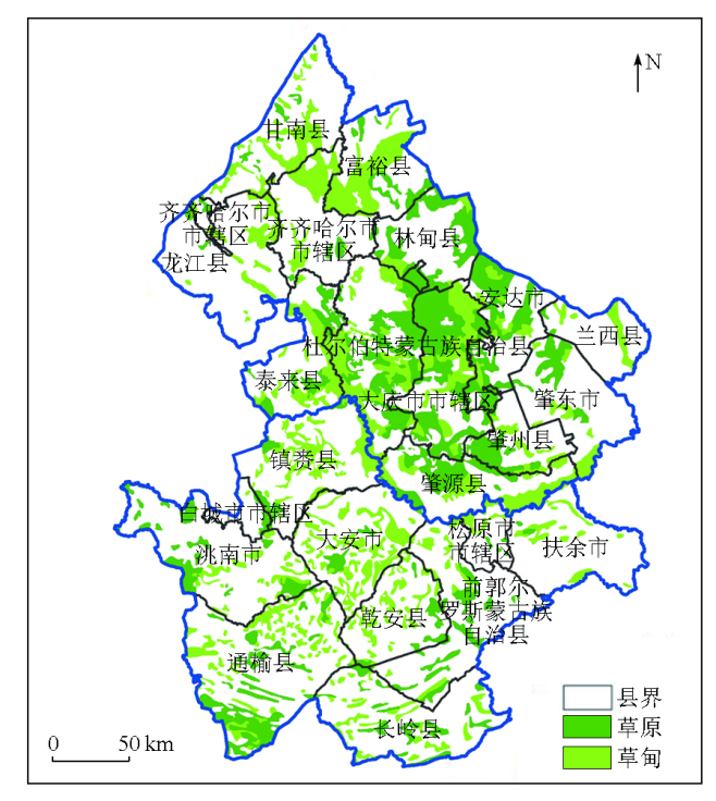
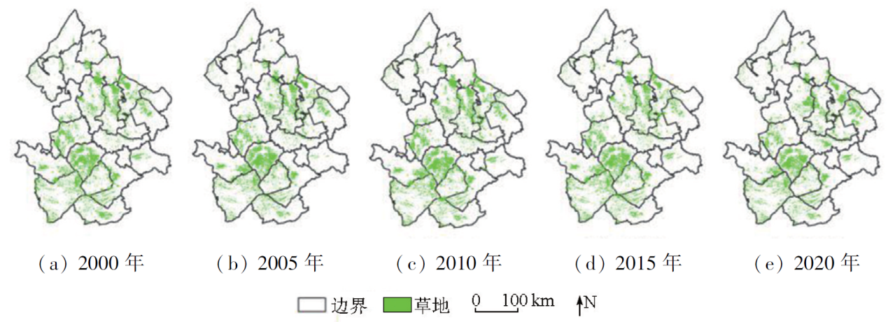
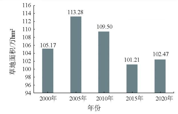
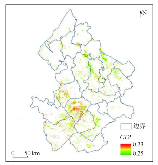
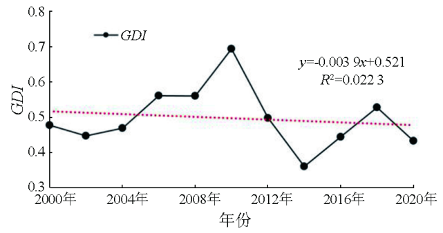
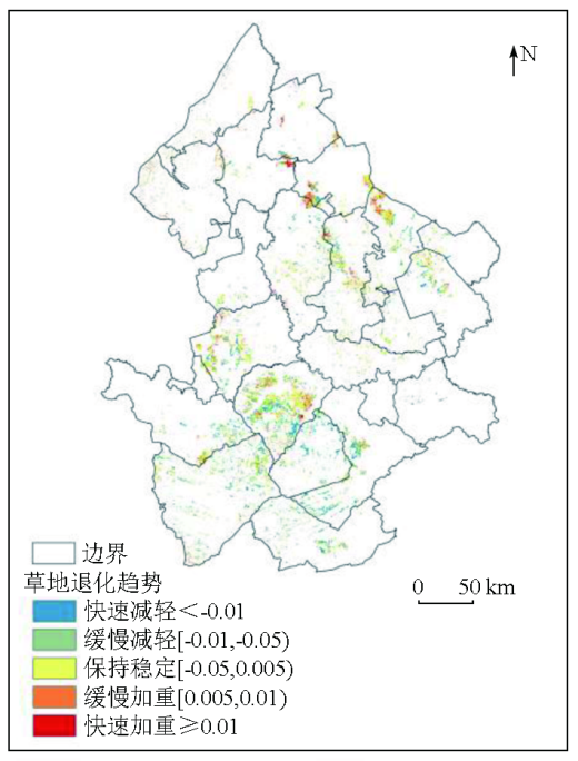
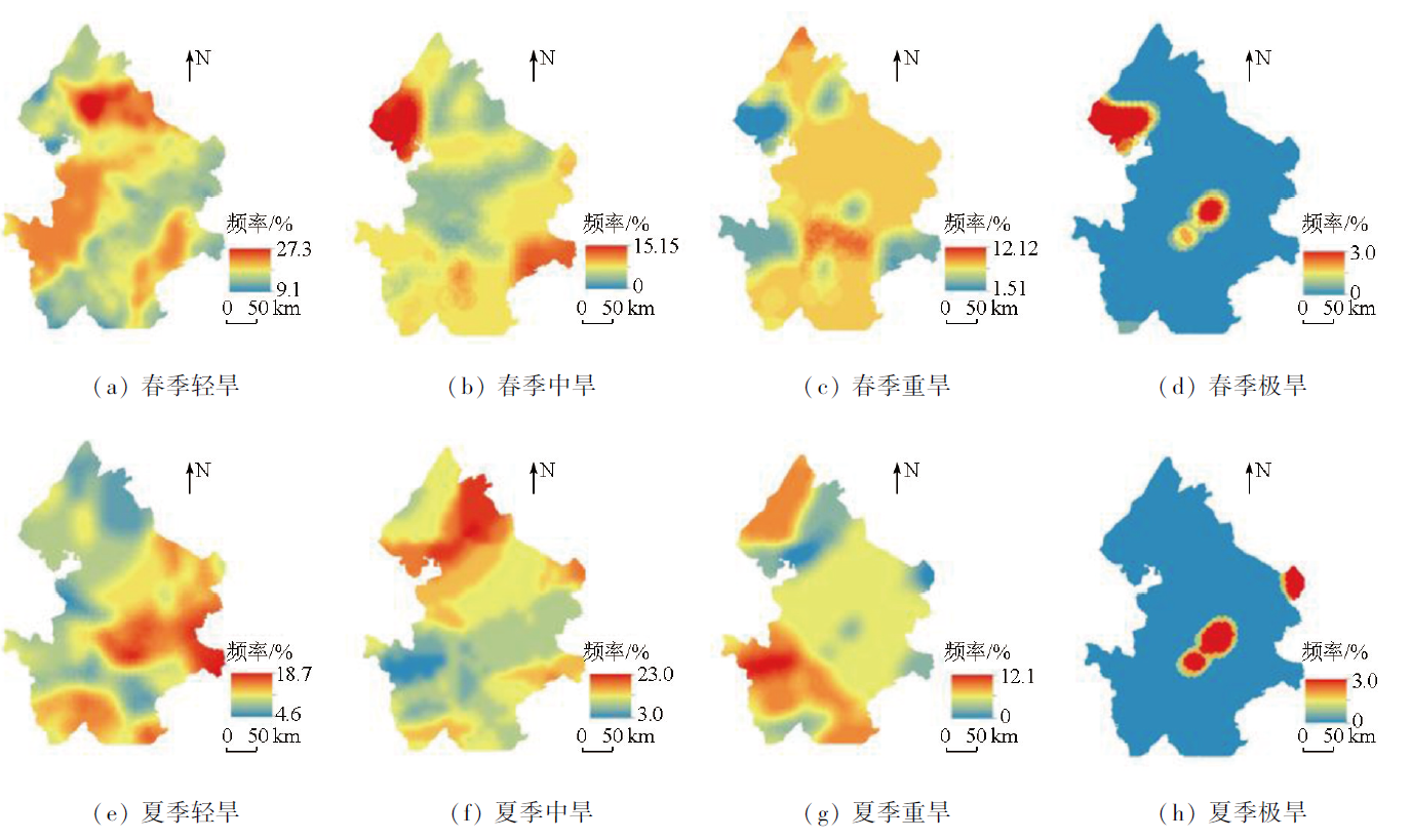
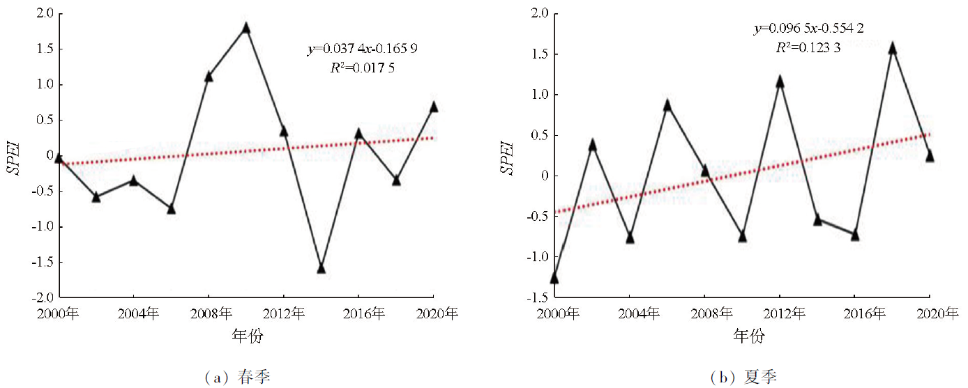
Abstract The grassland ecosystem is one of the most important and widely distributed terrestrial ecosystems. Analyzing the grassland degradation and its influential factors holds great significance for guiding the conservation and sustainable use of grassland resources, as well as the restoration and reconstruction of degraded ecosystems. This study extracted information on the distribution of grassland in western Songnen Plain using an object-oriented classification method and a multi-layer decision tree while comprehensively considering the degradation of vegetation and soils. Using Landsat TM image data, this study constructed a comprehensive grassland degradation index (GDI) for 11 even years from 2000 to 2020, followed by the assessment of the spatiotemporal dynamics of grassland degradation. Using the standardized precipitation evapotranspiration index (SPEI) as an indicator of drought, this study analyzed the responses of grassland degradation to the spatiotemporal changes in climate-induced drought. The results indicate that from 2000 to 2020, grassland in the western Songnen Plain decreased to 1 024 700 hm2 from 1 051 700 hm2, with an annual decreasing rate of 0.1%. The grassland degradation showed a nonsignificant downward trend, with 81.7% of the grassland exhibiting a stable or downward degradation trend. The SPEI exhibited an increasing trend in both spring and summer, representing a downward drought trend with significant regional differences. Besides, there was a nonsignificant weak positive correlation between GDI and SPEI in both spring and summer. The results of this study will provide data support for the conservation and sustainable use of grasslands in the western Songnen Plain, while also holding active significance for managing and controlling the ecological and economic benefits of grasslands in this region.
|
| Keywords
grassland degradation
comprehensive remote sensing index
SPEI
drought degree
western Songnen Plain
|
|
|
|
Issue Date: 17 February 2025
|
|
|
| [1] |
Scurlock J M O, Johnson K, Olson R J. Estimating net primary productivity from grassland biomass dynamics measurements[J]. Global Change Biology, 2002, 8(8):736-753.
|
| [2] |
Heath M E, Barnes R F, Metcalfe D S. Forages:The science of grassland agriculture[M]. Array Ames,Iowa, USA: Iowa State University Press,1985.
|
| [3] |
Liu Y, Zhang Z, Tong L, et al. Assessing the effects of climate variation and human activities on grassland degradation and restoration across the globe[J]. Ecological Indicators, 2019,106:105504.
|
| [4] |
Liu M, Dries L, Heijman W, et al. Land tenure reform and grassland degradation in Inner Mongolia,China[J]. China Economic Review, 2019,55:181-198.
|
| [5] |
王合云, 郭建英, 李红丽, 等. 短花针茅荒漠草原不同退化程度的植被特征[J]. 中国草地学报, 2015, 37(3):74-79.
|
| [5] |
Wang H Y, Guo J Y, Li H L, et al. Vegetation characteristics of Stipa breviflora desert steppe in different degradation degree[J]. Chinese Journal of Grassland, 2015, 37(3):74-79.
|
| [6] |
秦金萍, 刘颖, 马玉寿, 等. 返青期休牧对退化高寒草甸植被生长及其优势植物垂穗披碱草光合作用的影响[J]. 草地学报, 2020, 28(4):1068-1075.
doi: 10.11733/j.issn.1007-0435.2020.04.025
|
| [6] |
Qin J P, Liu Y, Ma Y S, et al. Effects of rest grazing during greenup period on plant growth of degraded alpine meadow and photosynthesis of its dominant plant Elymus nutans Griseb[J]. Acta Agrestia Sinica, 2020, 28(4):1068-1075.
|
| [7] |
刘晓光. 阴山北麓草原植被不同退化程度特征分析[J]. 内蒙古农业大学学报(自然科学版), 2015, 36(6):65-69.
|
| [7] |
Liu X G. Analysis of grassland vegetation characteristics at different degraded degree in the north foot region of Yinshan Mountain[J]. Journal of Inner Mongolia Agricultural University (Natural Science Edition), 2015, 36(6):65-69.
|
| [8] |
罗玲, 王宗明, 毛德华, 等. 松嫩平原西部草地净初级生产力对气候变化及人类活动的响应[J]. 生态学杂志, 2012, 31(6):1533-1540.
|
| [8] |
Luo L, Wang Z M, Mao D H, et al. Responses of grassland net primary productivity in western Songnen Plain of Northeast China to climate change and human activity[J]. Chinese Journal of Ecology, 2012, 31(6):1533-1540.
|
| [9] |
Wang L, Zheng S, Wang X. The spatiotemporal changes and the impacts of climate factors on grassland in the northern Songnen Plain (China)[J]. Sustainability, 2021, 13(12):6568.
|
| [10] |
薛鹏飞. 高寒草地退化遥感监测与综合评价——以甘南地区为例[D]. 兰州: 兰州大学, 2022.
|
| [10] |
Xue P F. Remote sensing monitoring and comprehensive evaluation of alpine grassland degradation[D]. Lanzhou: Lanzhou University, 2022.
|
| [11] |
陈曦. 中国干旱区自然地理[M]. 北京: 科学出版社,2010:7-9.
|
| [11] |
Chen X. Physical geography of arid land in China[M]. Beijing: Science Press,2010:7-9.
|
| [12] |
乌尼图, 刘桂香, 杨勇, 等. 基于光能利用率模型的内蒙古天然草原植被净初级生产力动态监测与气候因子的响应[J]. 草业学报, 2020, 29(11):1-10.
doi: 10.11686/cyxb2019543
|
| [12] |
Wu N T, Liu G X, Yang Y, et al. Dynamic monitoring of net primary productivity and its response to climate factors in native grassland in Inner Mongolia using a light-use efficiency model[J]. Acta Prataculturae Sinica, 2020, 29(11):1-10.
|
| [13] |
Vicente-Serrano S M, Beguería S, López-Moreno J I, et al. A new global 0.5° gridded dataset (1901—2006) of a multiscalar drought index:Comparison with current drought index datasets based on the palmer drought severity index[J]. Journal of Hydrometeorology,2010, 11(4):1033-1043.
|
| [14] |
郭嘉豪, 王会肖, 赵茹欣, 等. 基于多维Copula函数的松嫩平原干旱特征分析[J]. 节水灌溉, 2020(12):57-63,67.
|
| [14] |
Guo J H, Wang H X, Zhao R X, et al. Analysis of drought characteristics in Songnen Plain with multidimensional Copula function[J]. Water Saving Irrigation, 2020(12):57-63,67.
|
| [15] |
杨帆, 黄庆阳, 谢立红, 等. 松嫩平原草原退化原因及其生态恢复方法[J]. 国土与自然资源研究, 2021(4):90-92.
|
| [15] |
Yang F, Huang Q Y, Xie L H, et al. Causes of grassland degradation and ecological restoration methods in Songnen Plain[J]. Territory & Natural Resources Study, 2021(4):90-92.
|
| [16] |
李强. 不同恢复措施对松嫩平原退化草地的作用[D]. 长春: 东北师范大学, 2010.
|
| [16] |
Li Q. The effect of different restoration measures on degraded grassland in Songnen Plain[D]. Changchun: Northeast Normal University, 2010.
|
| [17] |
Li F, Jiang L, Wang X, et al. Estimating grassland aboveground biomass using multitemporal MODIS data in the West Songnen Plain,China[J]. Journal of Applied Remote Sensing, 2013, 7(1):073546.
|
| [18] |
Chen H, Liu X, Ding C, et al. Phenology-based residual trend analysis of MODIS-NDVI time series for assessing human-induced land degradation[J]. Sensors, 2018, 18(11):3676.
|
| [19] |
武爽, 冯险峰, 孔玲玲, 等. 气候变化及人为干扰对西藏地区草地退化的影响研究[J]. 地理研究, 2021, 40(5):1265-1279.
doi: 10.11821/dlyj020200594
|
| [19] |
Wu S, Feng X F, Kong L L, et al. Effects of climate variation and human activities on grassland degradation in Tibet[J]. Geographical Research, 2021, 40(5):1265-1279.
|
| [20] |
Yu T, Jiapaer G, Bao A, et al. Using synthetic remote sensing indicators to monitor the land degradation in a salinized area[J]. Remote Sensing, 2021, 13(15):2851.
|
| [21] |
Zhang M, Lal R, Zhao Y, et al. Spatial and temporal variability in the net primary production of grassland in China and its relation to climate factors[J]. Plant Ecology, 2017, 218(9):1117-1133.
|
| [22] |
江笑薇. 黄土高原地区干旱及土地利用变化对植被净初级生产力影响的量化研究[D]. 西安: 陕西师范大学, 2021.
|
| [22] |
Jiang X W. Quantitative study on the influence of drought and land use change on net primary productivity of vegetation in loess plateau[D]. Xi’an: Shaanxi Normal University, 2021.
|
| [23] |
张颖, 章超斌, 王钊齐, 等. 三江源1982—2012年草地植被覆盖度动态及其对气候变化的响应[J]. 草业科学, 2017, 34(10):1977-1990.
|
| [23] |
Zhang Y, Zhang C B, Wang Z Q, et al. Spatiotemporal dynamics of grassland coverage in response to climate change from 1982 to 2012 in the Three Rivers Source region,China[J]. Pratacultural Science,2017, 34(10):1977-1990.
|
| [24] |
Huang F, Wang P, Zhang J. Grasslands changes in the northern Songnen Plain,China during 1954—2000[J]. Environmental Monitoring and Assessment, 2012, 184(4):2161-2175.
doi: 10.1007/s10661-011-2107-6
pmid: 21614622
|
| [25] |
王静, 郭铌, 蔡迪花, 等. 玛曲县草地退牧还草工程效果评价[J]. 生态学报, 2009, 29(3):1276-1284.
|
| [25] |
Wang J, Guo N, Cai D H, et al. The effect evaluation of the program of restoring grazing to grasslands in Maqu County[J]. Acta Ecologica Sinica, 2009, 29(3):1276-1284.
|
| [26] |
石明明, 王喆, 周秉荣, 等. 青藏高原草地退化特征及其与气候因子的关系[J]. 应用生态学报, 2022, 33(12):3271-3278.
doi: 10.13287/j.1001-9332.202212.002
|
| [26] |
Shi M M, Wang Z, Zhou B R, et al. Characteristics of grassland degradation and its relationship with climate factors on Qinghai-Tibetan Plateau,China[J]. Chinese Journal of Applied Ecology, 2022, 33(12):3271-3278.
|
| [27] |
康振山, 张莎, 白雲, 等. 内蒙古草地净初级生产力时空变化及其对干旱的响应[J]. 草地学报, 2021, 29(1):156-165.
doi: 10.11733/j.issn.1007-0435.2021.01.019
|
| [27] |
Kang Z S, Zhang S, Bai Y, et al. Spatio-temporal changes of grassland net primary productivity (NPP) in inner Mongolia and its response to drought[J]. Acta Agrestia Sinica, 2021, 29(1):156-165.
|
| [28] |
Torresani L, Wu J, Masin R, et al. Estimating soil degradation in montane grasslands of north-eastern Italian Alps (Italy)[J]. Heliyon, 2019, 5(6):e01825.
|
| [29] |
Li H, Huang F, Hong X, et al. Evaluating satellite-observed ecosystem function changes and the interaction with drought in Songnen Plain,Northeast China[J]. Remote Sensing, 2022, 14(22):5887.
|
| [30] |
王浩男. 松嫩平原盐碱地景观格局演化及驱动力分析[D]. 长春: 吉林大学, 2021.
|
| [30] |
Wang H N. The saline-alkali land analysis of landscape pattern evolution and driving forces in Songnen plain[D]. Changchun: Jilin University, 2021.
|
| [31] |
李叶. 松嫩平原盐碱地植被状况时空变化精细化模型构建[D]. 长春: 吉林大学, 2022.
|
| [31] |
Li Y. Construction of refined model of temporal and spatial variation of vegetation status in saline alkali land of Songnen Plain[D]. Changchun: Jilin University, 2022.
|
| [32] |
满卫东, 刘明月, 王宗明, 等. 1990—2015年东北地区草地变化遥感监测研究[J]. 中国环境科学, 2020, 40(5):2246-2253.
|
| [32] |
Man W D, Liu M Y, Wang Z M, et al. Remote sensing investigation of grassland change in Northeast China during 1990—2015[J]. China Environmental Science, 2020, 40(5):2246-2253.
|
| [33] |
牛书丽, 蒋高明. 人工草地在退化草地恢复中的作用及其研究现状[J]. 应用生态学报, 2004, 15(9):1662-1666.
|
| [33] |
Niu S L, Jiang G M. Function of artificial grassland in restoration of degraded natural grassland and its research advance[J]. Chinese Journal of Applied Ecology, 2004, 15(9):1662-1666.
|
| [34] |
张世喆, 朱秀芳, 刘婷婷, 等. 气候变化下中国不同植被区总初级生产力对干旱的响应[J]. 生态学报, 2022, 42(8):3429-3440.
|
| [34] |
Zhang S Z, Zhu X F, Liu T T, et al. Response of gross primary production to drought under climate change in different vegetation regions of China[J]. Acta Ecologica Sinica, 2022, 42(8):3429-3440.
|
| [35] |
Jha S, Srivastava R. Impact of drought on vegetation carbon storage in arid and semi-arid regions[J]. Remote Sensing Applications:Society and Environment, 2018,11:22-29.
|
| [36] |
曹旭娟. 青藏高原草地退化及其对气候变化的响应[D]. 北京: 中国农业科学院, 2017.
|
| [36] |
Cao X J. Grassland degradation and its response to climate change in the Qinghai-Tibet Plateau[D]. Beijing: Chinese Academy of Agricultural Sciences, 2017.
|
| [37] |
李传新. 基于遥感的锡林河流域草地退化及影响因素分析[D]. 北京: 中国地质大学(北京), 2016.
|
| [37] |
Li C X. Analysis of grassland degradation and influencing factors based on remote sensing[D]. Beijing: China University of Geosciences, 2016.
|
| [38] |
Liu S, Zhang Y, Cheng F, et al. Response of grassland degradation to drought at different time-scales in Qinghai Province:Spatio-temporal characteristics,correlation,and implications[J]. Remote Sensing, 2017, 9(12):1329.
|
| [39] |
邹杰. 中亚地区生态系统水分利用效率时空分布及其干旱抗逆效应[D]. 乌鲁木齐: 新疆大学, 2020.
|
| [39] |
Zou J. Spatial and temporal distribution of ecosystem water use efficiency and drought tolerance effect in central Asia[D]. Urumqi: Xinjiang University, 2020.
|
| [40] |
Liu S L, Wang T, Kang W P, et al. Vegetation change and its response to drought in Inner Mongolia of Northern China from 1998 to 2013[J]. Sciences in Cold and Arid Regions, 2019, 11(6):448-460.
|
| [41] |
Bai Y, Li S. Growth peak of vegetation and its response to drought on the Mongolian Plateau[J]. Ecological Indicators, 2022,141:109150.
|
| [42] |
Zhao W K, Jing C Q. Response of the natural grassland vegetation change to meteorological drought in Xinjiang from 1982 to 2015[J]. Frontiers in Environmental Science, 2022,10:1047818.
|
|
Viewed |
|
|
|
Full text
|
|
|
|
|
Abstract
|
|
|
|
|
Cited |
|
|
|
|
| |
Shared |
|
|
|
|
| |
Discussed |
|
|
|
|
 2025,
Vol. 37
2025,
Vol. 37
 ), LI Xinye, LI Xiaoyan(