|
|
 |
|

|
|
|
A method for 3D modeling of trees based on terrestrial LiDAR point cloud |
WAN Lihong1,2( ), CAO Zhenyu1,3, TIAN Zhilin2, SHI Yanli1 ), CAO Zhenyu1,3, TIAN Zhilin2, SHI Yanli1 |
1. Sichuan Basic Geographic Information Center, Ministry of Natural Resources, Chengdu 610041,China
2. School of Resources and Environment, University of Electronic Science and Technology of China, Chengdu 611731, China
3. Technology Innovation Center of Emergency Surveying and Mapping, Ministry of Natural Resources, Chengdu 610041,China |
|
|
|
|
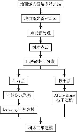
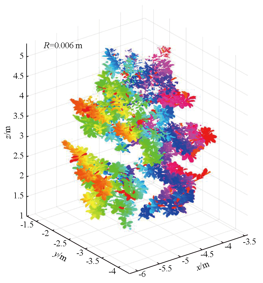
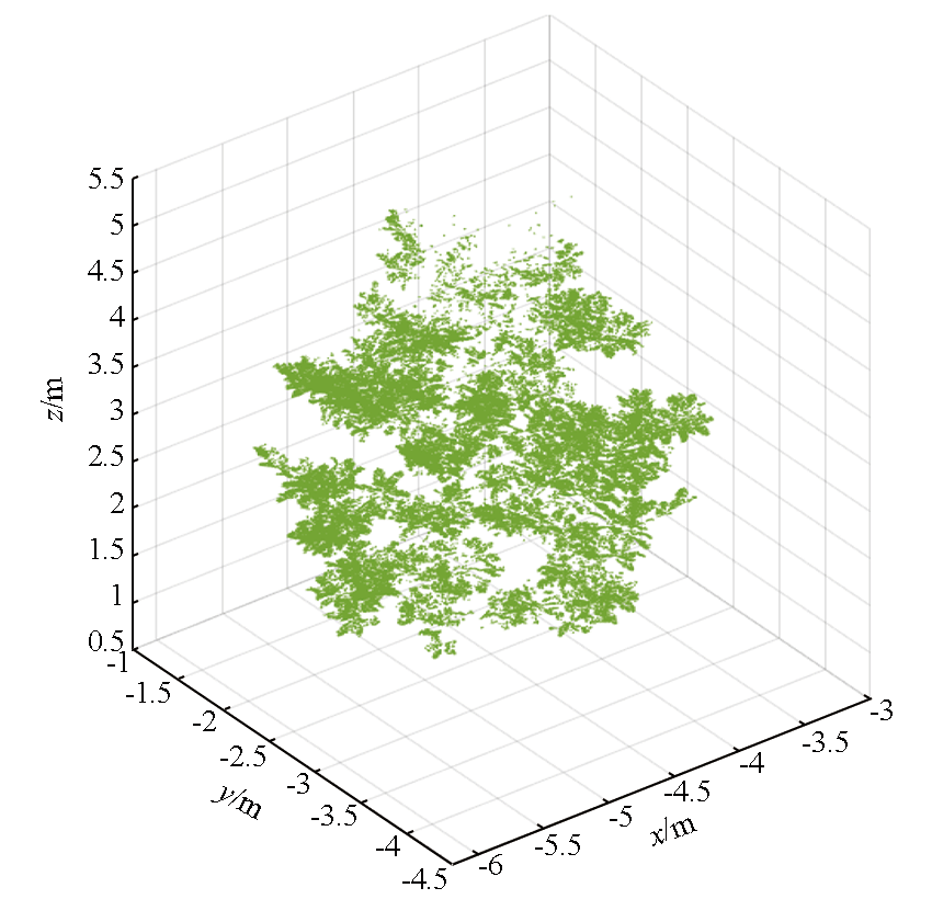
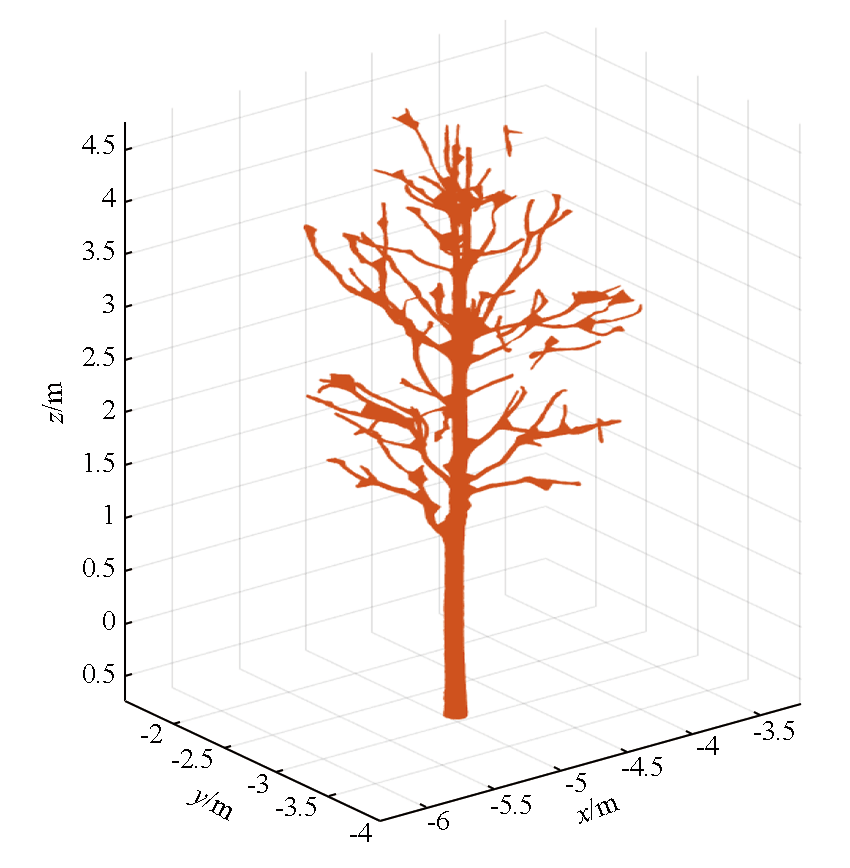
Abstract To capture information about the 3D geometric structures of trees more effectively and address the challenge of high-precision, high-fidelity tree reconstruction, this study proposed a method for 3D modeling of trees based on terrestrial LiDAR point cloud. To overcome the occlusion caused by leaf gaps in TLS, this method fully considered the aggregation of leaves, as well as the morphological characteristics of both leaves and branches. By conducting the model fitting and reconstruction of tree leaves and branches using Delaunay triangulation and Alpha-shape algorithm, respectively, the proposed method effectively addressed previous issues such as unrealistic tree structures and imprecise organ modeling, thus achieving the 3D reconstruction of individual tree leaves and small branches efficiently. This study holds great significance for determining forest structural parameters and managing resources, while also offering a valuable reference for component-level real scene 3D modeling of typical trees.
|
| Keywords
terrestrial laser scanning
point cloud
branch and leaf separation
3D real scene
tree 3D reconstruction
|
|
|
|
Issue Date: 17 February 2025
|
|
|
| [1] |
黄洪宇, 陈崇成, 邹杰, 等. 基于地面激光雷达点云数据的单木三维建模综述[J]. 林业科学, 2013, 49(4):123-130.
|
| [1] |
Huang H Y, Chen C C, Zou J, et al. Tree geometrical 3D modeling from terrestrial laser scanned point clouds:A review[J]. Scientia Silvae Sinicae, 2013, 49(4):123-130.
|
| [2] |
张天安, 云挺, 薛联凤, 等. 基于地面激光雷达的活立木枝干三维建模[J]. 南京林业大学学报(自然科学版), 2015, 39(4):163-167.
doi: 10.3969/j.issn.1000-2006.2015.04.028
|
| [2] |
Zhang T A, Yun T, Xue L F, et al. A new 3D modeling method for branches of standing trees based on point cloud data of terrestrial laser scanning[J]. Journal of Nanjing Forestry University (Natural Sciences Edition), 2015, 39(4):163-167.
|
| [3] |
卢军, 刘宪钊, 孟维亮, 等. 基于地面激光点云数据的单木三维重建方法[J]. 南京林业大学学报(自然科学版), 2021, 45(6):193-199.
doi: 10.12302/j.issn.1000-2006.202006016
|
| [3] |
Lu J, Liu X Z, Meng W L, et al. Methodology of individual tree 3D reconstruction based on terrestrial laser scanning point cloud data[J]. Journal of Nanjing Forestry University (Natural Sciences Edition), 2021, 45(6):193-199.
|
| [4] |
王向玉, 谢东辉, 汪艳, 等. 基于地面激光雷达点云数据的单木三维重建[J]. 遥感技术与应用, 2015, 30(3):455-460.
doi: 10.11873/j.issn.1004-0323.2015.3.0455
|
| [4] |
Wang X Y, Xie D H, Wang Y, et al. 3D reconstruction of a single tree from terrestrial laser scanner data[J]. Remote Sensing Technology and Application, 2015, 30(3):455-460.
|
| [5] |
Cheng Z L, Zhang X P, Chen B Q. Simple reconstruction of tree branches from a single range image[J]. Journal of Computer Science and Technology, 2007, 22(6):846-858.
|
| [6] |
苏中花. 基于地面激光雷达点云数据的单木三维建模[D]. 成都: 成都理工大学, 2019.
|
| [6] |
Su Z H. Three-dimensional model of individual tree based on terrestrial LiDAR scanner point cloud data[D]. Chengdu: Chengdu University of Technology, 2019.
|
| [7] |
王晓辉. 基于地面激光雷达点云的单树三维几何建模研究[D]. 福州: 福州大学, 2014.
|
| [7] |
Wang X H. Three dimensional geometrical modeling of individual tree from terrestrial LiDAR scanner point cloud[D]. Fuzhou: Fuzhou University, 2014.
|
| [8] |
段芸杉. 基于激光雷达点云数据的单木建模综述[J]. 测绘与空间地理信息, 2022, 45(5):80-82.
|
| [8] |
Duan Y S. Overview of single tree modeling based on LiDAR point clouds data[J]. Geomatics & Spatial Information Technology, 2022, 45(5):80-82.
|
| [9] |
李萍, 冯仲科, 苏珏颖. 定量结构模型的地面激光雷达单木分割应用[J]. 测绘科学, 2022, 47(2):151-156,199.
|
| [9] |
Li P, Feng Z K, Su J Y. Application of quantitative structure model in TLS single wood segmentation[J]. Science of Surveying and Mapping, 2022, 47(2):151-156,199.
|
| [10] |
傅根深, 陈健, 黄庆丰, 等. 基于地基激光雷达的单木森林参数提取分析[J]. 安徽农业科学, 2022, 50(4):128-131.
|
| [10] |
Fu G S, Chen J, Huang Q F, et al. Extraction and analysis of forest parameters for individual tree based on terrestrial laser scanning[J]. Journal of Anhui Agricultural Sciences, 2022, 50(4):128-131.
|
| [11] |
林筱涵, 李爱农, 边金虎, 等. 基于网络图的地基激光雷达复杂树木点云枝叶分离方法[J]. 遥感技术与应用, 2022, 37(1):161-172.
doi: 10.11873/j.issn.1004-0323.2022.1.0161
|
| [11] |
Lin X H, Li A N, Bian J H, et al. A method for separating leaf and wood components of complex tree point cloud data based on network graph with terrestrial laser scanning[J]. Remote Sensing Technology and Application, 2022, 37(1):161-172.
|
| [12] |
廖晓和. 基于车载点云数据的树木提取与分析[J]. 测绘通报, 2020(11):163-166.
doi: 10.13474/j.cnki.11-2246.2020.0378
|
| [12] |
Liao X H. Tree extraction and analysis based on vehicle point cloud data[J]. Bulletin of Surveying and Mapping, 2020(11):163-166.
doi: 10.13474/j.cnki.11-2246.2020.0378
|
| [13] |
李庆, 高祥伟, 费鲜芸, 等. 利用Alpha-shape算法进行树冠三维模型构建[J]. 测绘通报, 2018(12):91-95.
doi: 10.13474/j.cnki.11-2246.2018.0390
|
| [13] |
Li Q, Gao X W, Fei X Y, et al. Construction of tree crown three-dimensional model using alpha-shape algorithm[J]. Bulletin of Surveying and Mapping, 2018(12):91-95.
doi: 10.13474/j.cnki.11-2246.2018.0390
|
| [14] |
付昱兴, 李承明, 朱江, 等. Alpha-shape算法构建枣树点云三维模型[J]. 农业工程学报, 2020, 36(22):214-221.
|
| [14] |
Fu Y X, Li C M, Zhu J, et al. Three-dimensional model construction method and experiment of jujube tree point cloud using Alpha-shape algorithm[J]. Transactions of the Chinese Society of Agricultural Engineering, 2020, 36(22):214-221.
|
| [15] |
张波, 刘红伟, 裴小节. 基于三维激光点云数据建立三维树木模型方法的研究[J]. 安徽农业科学, 2011, 39(33):20904-20905,20930.
|
| [15] |
Zhang B, Liu H W, Pei X J. Research on the method of building 3D tree model based on 3D laser point cloud data[J]. Journal of Anhui Agricultural Sciences, 2011, 39(33):20904-20905,20930.
|
|
Viewed |
|
|
|
Full text
|
|
|
|
|
Abstract
|
|
|
|
|
Cited |
|
|
|
|
| |
Shared |
|
|
|
|
| |
Discussed |
|
|
|
|
 2025,
Vol. 37
2025,
Vol. 37