|
|
|
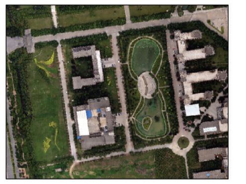
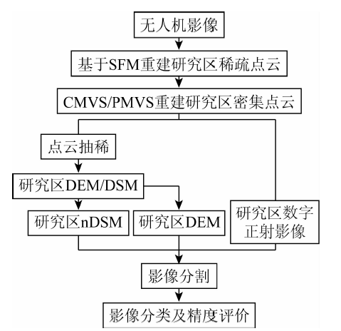
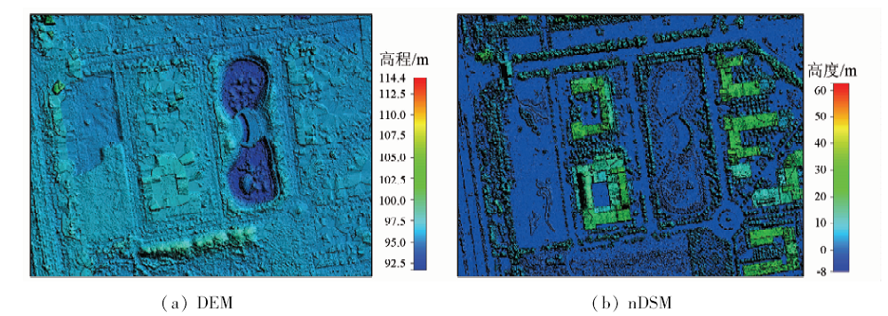
Abstract In order to solve the problem that unmanned aerial vehicle (UAV) remote sensing for urban vegetation classification usually uses the spectral texture and shape features information, while the reconstruction point cloud data of image fail to be fully used, the authors put forward a new method of comprehensive reconstruction point cloud and spectral information of image to extract the vegetation. The dense cloud of the study area was reconstructed based on structure from motion(SFM), cluster multi view stereo (CMVS) and patch based multi view stereo (PMVS) algorithm, and the digital elevation model (DEM) and normalized digital surface model (nDSM) of the study area were generated based on filtering and interpolation, meanwhile in combination with the spectral information of image the urban vegetation with different heights was extracted. On the basis of object-oriented image analysis method in combination with the nDSM information and spectral information including normalized green-red difference index and visible-band difference vegetation index, the classification rules of different vegetation, such as aquatic vegetation, grassland, shrub, small tree, and tree, were established. The experimental results show that the integration of the nDSM from point cloud data of image and spectral information to extract the vegetation with different heights is feasible, and the overall classification accuracy is 92.08%. The results obtained by the authors can provide theoretical support and application reference for urban vegetation classification and mapping.
|
| Keywords
UAV
reconstruction point cloud
nDSM
classification of urban vegetation
|
|
|
|
Corresponding Authors:
Haiyang YU
E-mail: yuhaiyang@hpu.edu.cn
|
|
Issue Date: 14 March 2019
|
|
|
| [1] |
杨柳, 陈延辉, 岳德鹏 , 等. 无人机遥感影像的城市绿地信息提取[J]. 测绘科学. 2017,42(2):59-64.
doi: 10.16251/j.cnki.1009-2307.2017.02.012
url: http://www.cnki.com.cn/Article/CJFDTOTAL-CHKD201702012.htm
|
| [1] |
Yang L, Chen Y H, Yue D P , et al. Information extraction of urban green space based on UAV remote sensing image[J]. Science of Surveying and Mapping, 2017,42(2):59-64.
|
| [2] |
田振坤, 傅莺莺, 刘素红 , 等. 基于无人机低空遥感的农作物快速分类方法[J]. 农业工程学报. 2013,29(7):109-116.
doi: 10.3969/j.issn.1002-6819.2013.07.014
url: http://www.cnki.com.cn/Article/CJFDTotal-NYGU201307016.htm
|
| [2] |
Tian Z K, Fu Y Y, Liu S H , et al. Rapid crops classification based on UAV low-altitude remote sensing[J]. Transactions of the Chinese Society of Agricultural Engineering, 2013,29(7):109-116.
|
| [3] |
汪小钦, 王苗苗, 王绍强 , 等. 基于可见光波段无人机遥感的植被信息提取[J]. 农业工程学报. 2015,31(5):152-159.
doi: 10.3969/j.issn.1002-6819.2015.05.022
url: http://d.wanfangdata.com.cn/Periodical/nygcxb201505022
|
| [3] |
Wang X Q, Wang M M, Wang S Q , et al. Extraction of vegetation information from visible unmanned aerial vehicle images[J]. Transactions of the Chinese Society of Agricultural Engineering, 2015,31(5):152-159.
|
| [4] |
井然, 邓磊, 赵文吉 , 等. 基于可见光植被指数的面向对象湿地水生植被提取方法[J]. 应用生态学报. 2016,27(5):1427-1436.
doi: 10.13287/j.1001-9332.201605.002
url: http://www.cnki.com.cn/Article/CJFDTotal-YYSB201605012.htm
|
| [4] |
Jing R, Deng L, Zhao W J , et al. Object-oriented aquatic vegetation extracting approach based on visible vegetation indices[J]. Chinese Journal of Applied Ecology, 2016,27(5):1427-1436.
|
| [5] |
周在明, 杨燕明, 陈本清 . 基于可见光波段无人机影像的入侵物种互花米草提取研究[J]. 亚热带资源与环境学报. 2017,12(2):90-95.
url: http://www.cqvip.com/QK/83207A/201702/672775368.html
|
| [5] |
Zhou Z M, Yang Y M, Chen B Q . Study on the extraction of exotic species Spartina alterniflora from UAV visible images[J]. Journal of Subtropical Resources and Environment, 2017,12(2):90-95.
|
| [6] |
Wu C C . VisualSFM: A visual structure from motion system[EB/OL]. .
url: http://ccwu.me/vsfm/
|
| [7] |
苏伟, 李京, 陈云浩 , 等. 基于多尺度影像分割的面向对象城市土地覆被分类研究——以马来西亚吉隆坡市城市中心区为例[J]. 遥感学报. 2007,11(4):521-530.
doi: 10.3321/j.issn:1007-4619.2007.04.013
url: http://www.cqvip.com/Main/Detail.aspx?id=25923283
|
| [7] |
Su W, Li J, Chen Y H , et al. Object-oriented urban land-cover classification of multi-scale image segmentation method——A case study in Kuala Lumpur City Center,Malaysia[J]. Journal of Remote Sensing, 2007,11(4):521-530.
|
| [8] |
何豫航, 岳俊 . 基于CMVS/PMVS多视角密集匹配方法的研究与实现[J]. 测绘地理信息. 2013,38(3):20-23.
url: http://d.wanfangdata.com.cn/Periodical/chxxygc201303006
|
| [8] |
He Y H, Yue J . Research and implementation based on multi-view dense matching by applying CMVS/PMVS[J]. Journal of Geomatics, 2013,38(3):20-23.
|
| [9] |
Furukawa Y, Ponce J . Accurate camera calibration from multi-view stereo and bundle adjustment[J]. International Journal of Computer Vision, 2009,84(3):257-268.
doi: 10.1007/s11263-009-0232-2
url: http://link.springer.com/10.1007/s11263-009-0232-2
|
| [10] |
李俊利, 李斌兵, 柳方明 , 等. 利用照片重建技术生成坡面侵蚀沟三维模型[J]. 农业工程学报, 2015,31(1):125-132.
doi: 10.3969/j.issn.1002-6819.2015.01.018
url: http://www.cqvip.com/QK/71135X/201107/665302878.html
|
| [10] |
Li J L, Li B B, Liu F M , et al. Generating 3D model of slope eroded gully based on photo reconstruction technique[J]. Transactions of the Chinese Society of Agricultural Engineering, 2015,31(1):125-132.
|
| [11] |
方磊 . 基于特征的图像序列三维场景重建技术研究[D]. 武汉:华中科技大学, 2006.
|
| [11] |
Fang L . Research on Feature Based 3D Scene Reconstruction Techniques from Image Sequence[D]. Wuhan:Huazhong University of Science and Technology, 2006.
|
| [12] |
戴嘉境 . 基于多幅图像的三维重建理论及算法研究[D]. 上海:上海交通大学, 2012.
|
| [12] |
Dai J J . Research on the Theory and Algorithms of 3D Reconstruction from Multiple Images[D]. Shanghai:Shanghai Jiao Tong University, 2012.
|
| [13] |
张平, 王山东, 黄瑾娉 , 等. 基于SFM和CMVS/PMVS的建筑物点云重构方法研究[J]. 苏州科技学院学报(自然科学版). 2015,32(3):60-64.
doi: 10.3969/j.issn.1672-0687.2015.03.013
url: http://www.cqvip.com/QK/90697A/201503/666078990.html
|
| [13] |
Zhang P, Wang S D, Huang J P , et al. Research on building point cloud reconstruction method based on SFM and CMVS/PMVS[J]. Journal of Suzhou University of Science and Technology(Natural Science), 2015,32(3):60-64.
|
| [14] |
傅银贞, 汪小钦 . 基于北京一号CCD数据的植被指数特性分析[J]. 测绘科学, 2010,35(6):35-38.
url: http://d.wanfangdata.com.cn/Periodical/chkx201006011
|
| [14] |
Fu Y Z, Wang X Q . Analysis of vegetation indices based on the CCD data of BJ-1[J]. Science of Surveying and Mapping, 2010,35(6):35-38.
|
| [15] |
Meyer G E, Neto J C . Verification of color vegetation indices for automated crop image application[J]. Computers and Electronics in Agriculture, 2008,63(2):282-293.
doi: 10.1016/j.compag.2008.03.009
url: https://linkinghub.elsevier.com/retrieve/pii/S0168169908001063
|
|
Viewed |
|
|
|
Full text
|
|
|
|
|
Abstract
|
|
|
|
|
Cited |
|
|
|
|
| |
Shared |
|
|
|
|
| |
Discussed |
|
|
|
|
 2019,
Vol. 31
2019,
Vol. 31
 ), Yan WANG, Jianpeng WU, Li YANG