|
|
 |
|

|
|
|
Data quality assessment of the AMS-3000 wide-field three-linear-array stereoscopic aerial survey system |
LI Tianqi1( ), ZHANG Xian1(), JIN Dingjian1, GAO Zihong1, HAN Yachao1, XU Ning2, GAO Han3, LI Gongxin2 ), ZHANG Xian1(), JIN Dingjian1, GAO Zihong1, HAN Yachao1, XU Ning2, GAO Han3, LI Gongxin2 |
1. China Aero Geophysical Survey and Remote Sensing Center for Natural Resources, Beijing 100083, China
2. Shandong Provincial No.4 Institute of Geological and Mineral Survey, Weifang 261021, China
3. Shandong Institute of Coal Geology Planning and Exploration, Jinan 250102, China |
|
|
|
|
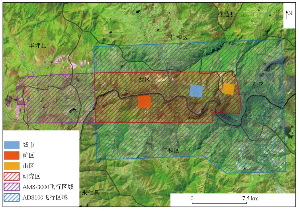
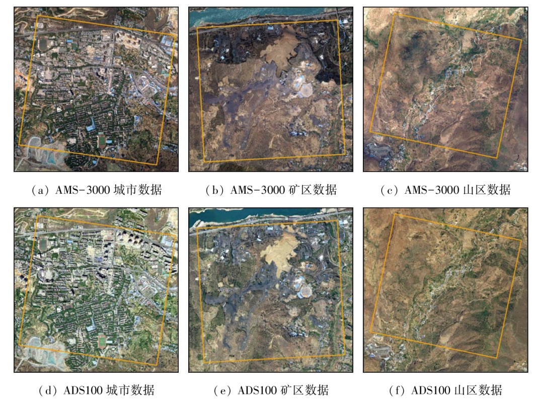
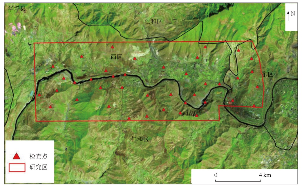
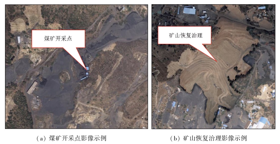
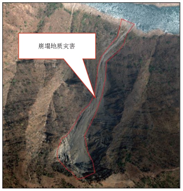
Abstract The AMS-3000 wide-field three-linear-array stereoscopic aerial survey system (hereafter referred to as the AMS-3000 system) is China’s first independently developed airborne linear-array aerial survey system. It can obtain panchromatic and R-, G-, and B-band multispectral images. However, the data quality of these images lacks quantitative assessments and analyses. Focusing on the area along the Jinsha River within western Panzhihua City, Sichuan Province, this study assessed the spectral quality of the data obtained from the AMS-3000 system in terms of grayscale, texture, and energy features, and noise level. Moreover, this study compared the AMS-3000 system with the internationally recognized ADS100 aerial photography system and assessed the geometric accuracy of the AMS-3000 system using the 1∶2 000-scale terrain data. Additionally, this study analyzed the effectiveness of the AMS-3000 system in the geological industry by applying it to the investigation of the mineral resource exploitation status and geologic hazards. Overall, this study serves as a reference for the application promotion and improvement of the AMS-3000 system.
|
| Keywords
airborne remote sensing
wide-field three-linear-array stereoscopic aerial survey system
data quality assessment
geological application
|
|
|
|
Issue Date: 01 July 2025
|
|
|
| [1] |
陈洁, 高子弘, 王珊珊, 等. 三峡库区航空遥感地质调查技术发展综述[J]. 国土资源遥感, 2020, 32(2):1-10.doi:10.6046/gtzyyg.2020.02.01.
|
| [1] |
Chen J, Gao Z H, Wang S S, et al. A review on the development of aerial remote sensing geological survey technology in the Three Gorges Reservoir area[J]. Remote Sensing for Land and Resources, 2020, 32(2):1-10.doi:10.6046/gtzyyg.2020.02.01.
|
| [2] |
许强, 郭晨, 董秀军. 地质灾害航空遥感技术应用现状及展望[J]. 测绘学报, 2022, 51(10):2020-2033.
doi: 10.11947/j.AGCS.2022.20220302
|
| [2] |
Xu Q, Guo C, Dong X J. Application status and prospect of aerial remote sensing technology for geohazards[J]. Acta Geodaetica et Cartographica Sinica, 2022, 51(10):2020-2033.
doi: 10.11947/j.AGCS.2022.20220302
|
| [3] |
姚园, 许永森, 丁亚林, 等. 大视场三线阵航空测绘相机光学系统设计[J]光学精密工程, 2018, 26(9):2335-2344.
|
| [3] |
Yao Y, Xu Y S, Ding Y L, et al. Optical-system design for large field-of-view three-line array airborne mapping camera[J]. Optics and Precision Engineering, 2018, 26(9):2335-2344.
|
| [4] |
朱芳芳. 基于ADS100影像的城市建筑物信息提取[D]. 兰州: 兰州交通大学, 2020.
|
| [4] |
Zhu F F. Extracting urban building information based on ADS100 images[D]. Lanzhou: Lanzhou Jiaotong University, 2020.
|
| [5] |
金鼎坚, 王建超, 吴芳, 等. 航空遥感技术及其在地质调查中的应用[J]. 国土资源遥感, 2019, 31(4):1-10.doi:10.6046/gtzyyg.2019.04.01.
|
| [5] |
Jin D J, Wang J C, Wu F, et al. Aerial remote sensing technology and its applications in geological survey[J]. Remote Sensing for Land and Resources, 2019, 31(4):1-10.doi:10.6046/gtzyyg.2019.04.01.
|
| [6] |
王涛, 张艳, 张永生, 等. 国产机载大视场三线阵CCD相机GNSS偏心矢量和IMU视轴偏心角标定技术[J]. 测绘学报, 2018, 47(11):1474-1486.
doi: 10.11947/j.AGCS.2018.20170679
|
| [6] |
Wang T, Zhang Y, Zhang Y S, et al. Investigation on GNSS lever arms and IMU bore sight misalignment calibration of domestic airborne wide-field three CCD camera[J]. Acta Geodaetica et Cartographica Sinica, 2018, 47(11):1474-1486.
|
| [7] |
王涛, 张艳, 张永生, 等. 国产机载大视场三线阵CCD相机几何标定[J]. 遥感学报, 2020, 24(6):739-751.
|
| [7] |
Wang T, Zhang Y, Zhang Y S, et al. Geometric calibration of domestic airborne wide-field three-linear CCD camera[J]. Journal of Remote Sensing, 2020, 24(6):739-751.
|
| [8] |
张峰, 桑夺坤. 徕卡ADS100相机使用运-5飞行平台在1∶500地形图测绘中的应用[J]. 测绘通报, 2015(8): 133-134.
|
| [8] |
Zhang F, Sang D K. The application of Leica ADS100 camera using Yun-5 flight platform in 1∶500 topographic mapping[J]. Bulletin of Surveying and Mapping, 2015(8):133-134.
|
| [9] |
吴兴, 张霞, 孙雪剑, 等. SPARK卫星高光谱数据辐射质量评价[J]. 遥感技术与应用, 2018, 33(2): 233-240.
doi: 10.11873/j.issn.1004-0323.2018.2.0233
|
| [9] |
Wu X, Zhang X, Sun X J, et al. Radiation quality evaluation of SPARK hyperspectral satellite image[J]. Remote Sensing Techno-logy and Application, 2018, 33(2):233-240.
|
| [10] |
刘睿, 孙九林, 王卷乐, 等. 环境与灾害监测预报小卫星CCD 数据质量评价[J]. 地球科学进展, 2011, 26 (9):971-979.
|
| [10] |
Liu R, Sun J L, Wang J L, et al. Data quality evaluation of Chinese HJ CCD sensor[J]. Advances in Earth Science, 2011, 26 (9):971-979.
|
| [11] |
覃帮勇. 高光谱遥感数据质量评价体系及方法研究[D]. 北京: 中国科学院大学, 2014.
|
| [11] |
Qin B Y. Study on the quality evaluation system and method of hyperspectral remote sensing data[D]. Beijing: University of Chinese Academy of Sciences, 2014.
|
| [12] |
周雨霁, 田庆久. EO-1 Hyperion高光谱数据的质量评价[J]. 地球信息科学, 2008, 10(5):678-683.
|
| [12] |
Zhou Y J, Tian Q J. Image quality evaluation of EO-1 Hyperion sensor[J]. Geo-Information Science, 2008, 10(5):678-683.
|
| [13] |
曹春旭. 资源一号02C卫星数据质量评价[D]. 北京: 中国地质大学(北京), 2014.
|
| [13] |
Cao C X. Date quality evaluation of ZY-1-02C satellite[D]. Beijing: China University of Geosciences (Beijing), 2014.
|
| [14] |
王崇倡, 薛荣荣, 赵世湖, 等. GF-5卫星高光谱影像数据质量评价与分析[J]. 地理与地理信息科学, 2021, 37(1):33-38,125.
|
| [14] |
Wang C C, Xue R R, Zhao S H, et al. Quality evaluation and analysis of GF-5 hyperspectral image data[J]. Geography and Geo-Information Science, 2021, 37(1):33-38,125.
|
| [15] |
张立福, 王飒, 颜军, 等. 珠海一号高光谱数据辐射质量评价[J]. 遥感学报, 2023, 27(8):1925-1935.
|
| [15] |
Zhang L F, Wang S, Yan J, et al. Quality evaluation of orbita hyperspectral images[J]. National Remote Sensing Bulletin, 2023, 27(8):1925-1935.
|
| [16] |
孙韬, 王鹏波, 方俊永, 等. 天绘一号03星三线阵/多光谱载荷影像质量评价[J]. 遥感学报, 2016, 20(6):1335-1341.
|
| [16] |
Sun T, Wang P B, Fang J Y, et al. Image quality assessment of the three-linear-array/multispectral sensors of Mapping Satellite-1 03[J]. Journal of Remote Sensing, 2016, 20(6):1335-1341.
|
| [17] |
田艳琴, 郭平, 卢汉清. 基于灰度共生矩阵的多波段遥感图像纹理特征的提取[J]. 计算机科学, 2004, 31(12):162-163,195.
|
| [17] |
Tian Y Q, Guo P, Lu H Q. Texture feature extraction of multiband remote sensing image based on gray level co-occurrence matrix[J]. Computer Science, 2004, 31(12):162-163,195.
|
| [18] |
薄华, 马缚龙, 焦李成. 图像纹理的灰度共生矩阵计算问题的分析[J]. 电子学报, 2006, 34(1):155-158,134.
|
| [18] |
Bo H, Ma F L, Jiao L C. Research on computation of GLCM of image texture[J]. Acta Electronica Sinica, 2006, 34(1):155-158,134.
|
| [19] |
刘丽, 匡纲要. 图像纹理特征提取方法综述[J]. 中国图象图形学报, 2009, 14(4):622-635.
|
| [19] |
Liu L, Kuang G Y. Overview of image textural feature extraction methods[J]. Journal of Image and Graphics, 2009, 14(4):622-635.
|
| [20] |
侯群群, 王飞, 严丽. 基于灰度共生矩阵的彩色遥感图像纹理特征提取[J]. 国土资源遥感, 2013, 25(4):26-32.doi:10.6046/gtzyyg.2013.04.05.
|
| [20] |
Hou Q Q, Wang F, Yan L. Extraction of color image texture feature based on gray-level co-occurrence matrix[J]. Remote Sensing for Land and Resources, 2013, 25(4):26-32.doi:10.6046/gtzyyg.2013.04.05.
|
| [21] |
姚成, 赵晋陵. 泰国THEOS遥感影像质量评价[J]. 安徽农业大学学报, 2015, 42(2):316-321.
|
| [21] |
Yao C, Zhao J L. Quality evaluation of the THEOS satellite imagery using textural and spectral features[J]. Journal of Anhui Agricultural University, 2015, 42(2):316-321.
|
| [22] |
Haralick R M. Image texture survey[M]. Handbook of Statistics, 1982,2:399-415.
|
| [23] |
徐文, 龙小祥, 李庆鹏. “高分二号”卫星相机影像辐射质量评价[J]. 航天返回与遥感, 2015, 36(4):1-9.
|
| [23] |
Xu W, Long X X, Li Q P. Radiometric image quality assessment of GF-2 satellite PMS camera[J]. Spacecraft Recovery and Remote Sensing, 2015, 36(4):1-9.
|
| [24] |
徐文, 龙小祥, 李庆鹏, 等. “高分四号”卫星影像辐射与几何精度评价[J]. 航天返回与遥感, 2016, 37(4):16-25.
|
| [24] |
Xu W, Long X X, Li Q P, et al. Image radiometric and geometric accuracy evaluation of GF-4 satellite[J]. Spacecraft Recovery and Remote Sensing, 2016, 37(4):16-25.
|
| [25] |
马晶, 王荣彬, 高娟, 等. 一种遥感影像的自动噪声评价方法[J]. 遥感信息, 2012, 27(3):78-82.
|
| [25] |
Ma J, Wang R B, Gao J, et al. An automatic noise evaluation me-thod of remote sensing image[J]. Remote Sensing Information, 2012, 27(3):78-82.
|
| [26] |
王春媛. 遥感图像几何校正及目标识别技术研究[D]. 哈尔滨: 哈尔滨工业大学, 2014.
|
| [26] |
Wang C Y. Research on geometric correction and object recognition for remote sensing image[D]. Harbin: Harbin Institute of Techno-logy, 2014.
|
| [27] |
魏丹丹, 甘甫平, 尚坤, 等. CBERS-04星PAN/MUX图像几何定位精度评价[J]. 无线电工程, 2018, 48(5):401-405.
|
| [27] |
Wei D D, Gan F P, Shang K, et al. Evaluation of geometric positional accuracy of PAN /MUX image for CBERS-04 satellite[J]. Radio Engineering, 2018, 48(5):401-405.
|
| [28] |
国家测绘局.CH/T 9008.1—2010基础地理信息数字成果1∶500、1∶1 000、1∶2 000数字线划图[S]. 北京: 国家测绘局, 2010.
|
| [28] |
State Bureau of Surveying and Mapping. CH/T 9008.1-2010 Digital products of fundamental geographic information 1∶500,1∶1 000,1∶2 000 digital line graphs[S]. Beijing: State Bureau of Surveying and Mapping, 2010.
|
| [29] |
国家测绘局.CH/T 9008.2—2010基础地理信息数字成果1∶500、1∶1 000、1∶2 000数字高程模型[S]. 北京: 国家测绘局, 2010.
|
| [29] |
State Bureau of Surveying and Mapping. CH/T 9008.2-2010 Digital products of fundamental geographic information 1∶500,1∶1 000,1∶2 000 digital line graphs[S]. Beijing: State Bureau of Surveying and Mapping, 2010.
|
| [30] |
国家测绘局.CH/T 9008.3—2010基础地理信息数字成果1∶500、1∶1 000、1∶2 000数字正射影像图[S]. 北京: 国家测绘局, 2010.
|
| [30] |
State Bureau of Surveying and Mapping. CH/T 9008.3-2010 Digital products of fundamental geographic information 1∶500,1∶1 000,1∶2 000 digital line graphs[S]. Beijing: State Bureau of Surveying and Mapping, 2010.
|
| [31] |
郑雄伟, 彭孛, 尚坤. 基于国产卫星的遥感地质解译能力评估[J]. 自然资源遥感, 2021, 33(3):1-10.doi:10.6046/zrzyyg.2020357.
|
| [31] |
Zheng X W, Peng B, Shang K. Assessment of the interpretation ability of domestic satellites in geological remote sensing[J]. Remote Sensing for Natural Resources, 2021, 33(3):1-10.doi:10.6046/zrzyyg.2020357.
|
| [32] |
陈玲, 贾佳, 王海庆. 高分遥感在自然资源调查中的应用综述[J]. 国土资源遥感, 2019, 31(1):1-7.doi:10.6046/gtzyyg.2019.01.01.
|
| [32] |
Chen L, Jia J, Wang H Q. An overview of applying high resolution remote sensing to natural resources survey[J]. Remote Sensing for Land and Resources, 2019, 31(1):1-7.doi:10.6046/gtzyyg.2019.01.01.
|
|
Viewed |
|
|
|
Full text
|
|
|
|
|
Abstract
|
|
|
|
|
Cited |
|
|
|
|
| |
Shared |
|
|
|
|
| |
Discussed |
|
|
|
|
 2025,
Vol. 37
2025,
Vol. 37