|
|
 |
|

|
|
|
Multifactor-based assessment of forest fire risk in Chongqing City, China |
CHEN Yanying1( ), YOU Yangsheng2(), YANG Qian3, WANG Yanbo4 ), YOU Yangsheng2(), YANG Qian3, WANG Yanbo4 |
1. CMA Key Open Laboratory of Transforming Climate Resources to Economy, Chongqing Institute of Meteorological Sciences, Chongqing 401147, China
2. School of Civil Engineering,Chongqing University Chongqing 400045, China
3. Chongqing Meteorological Station, Chongqing 401147, China
4. Chaoyang Normal University, Chaoyang 122000, China |
|
|
|
|
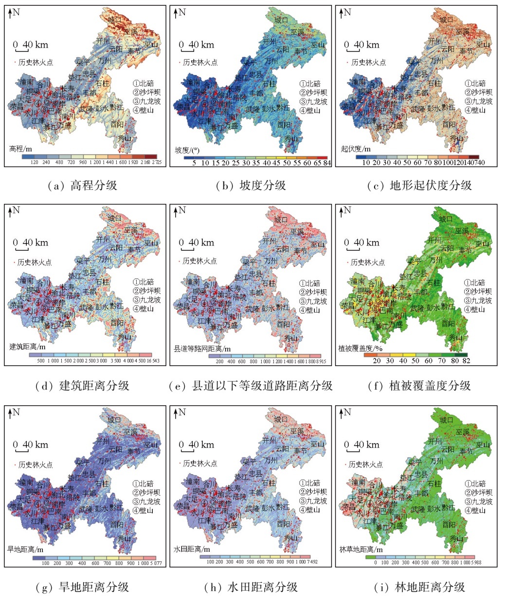
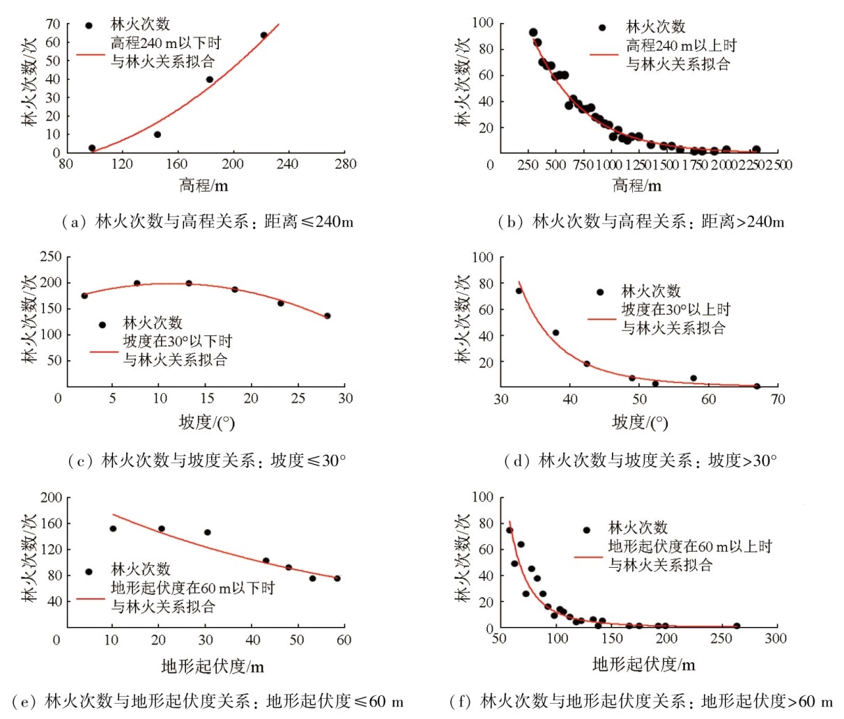
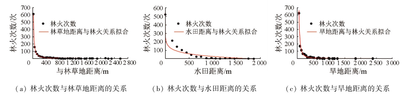
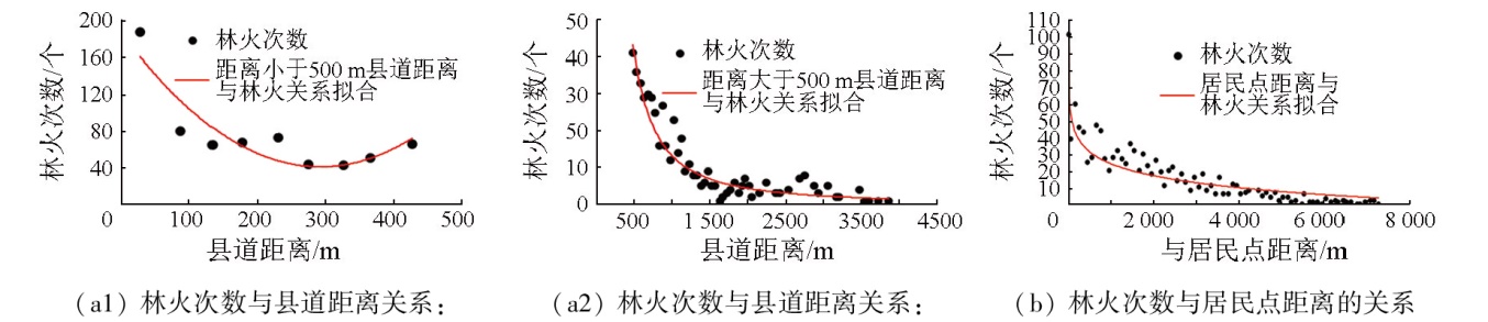
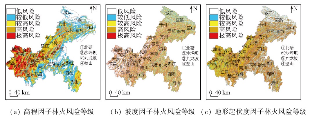
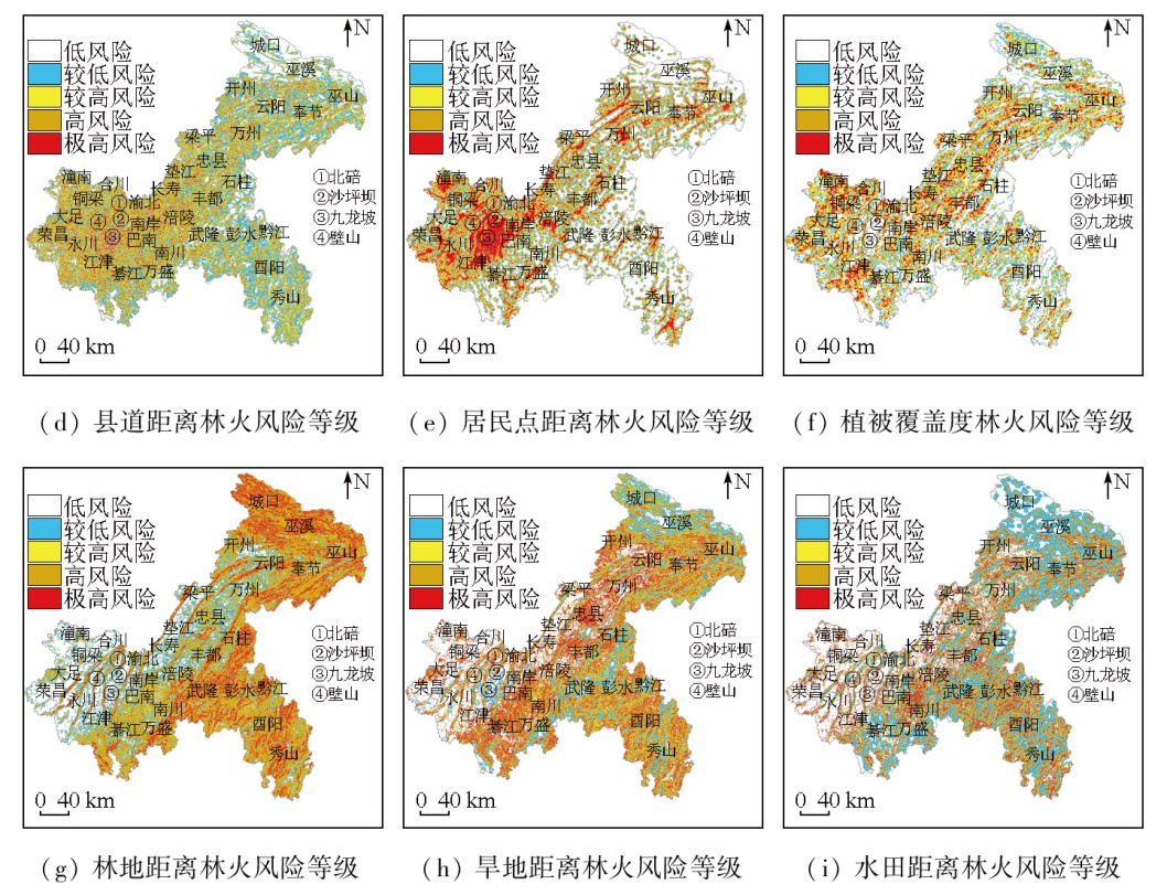
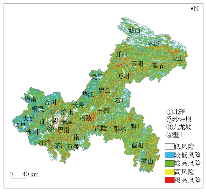
Abstract By objectively assessing the response of forest fires to factors like terrain, vegetation, and human activities, this study aims to provide technical guidance for forest fire prevention and risk zoning in Chongqing City, China. In this study, 1 206 historical forest fire data of Chongqing City from 2000 to 2022 were used as dependent variables. The height, slope, terrain ruggedness, vegetation cover, land cover classification, and road network distance data were utilized as forest fire risk factors. With these data, a piecewise function was established to obtain the single-factor risk probabilities of forest fires. Based on the criteria importance through intercriteria correlation (CRITIC), the weights of the single-factor risk probabilities of forest fires were calculated to derive the spatial distribution of weighted forest fire risk probabilities in Chongqing City. Finally, according to the risk probabilities of forest fires, the forest fire risk in Chongqing City was divided into the low, relatively low, relatively high, high, and extremely high levels. The results indicate that among nine forest fire risk factors, the contributions of forest land, dry land, and vegetation cover to forest fire risk ranked top three, whereas the slope, height, and terrain ruggedness contributed little to forest fire risk. The forest fire risk levels of Chongqing City based on the weights of single-factor risk probabilities demonstrated satisfactory verification effects. Forest fires falling in zones at relatively high and above risk levels represented 83 %. In contrast, forest fires falling in zones at low and relatively low risk levels represented 8.33 % and 8.67 %, respectively. The forest fire risk in Chongqing City was intimately associated with the terrain trend, land use, and human activities. The high-risk and extremely high-risk zones were primarily distributed in low to middle mountain forest areas subjected to frequent human activities. Additionally, the areas surrounding forest land, located near farmland, rural roads, residential areas, and cemeteries, were also classified into high-risk zones since the frequent use of fire for production and daily life was prone to induce forest fires. The low-risk zones included primarily low and flat non-forest areas and steep forest areas, along with building land, water bodies, and paddy and dry lands that are far from forest land. Overall, the results of this study can be used to assess the spatial distribution of forest fire risk, providing scientific guidance for forest fire prevention.
|
| Keywords
forest fire risk
impact factors
risk probability
risk level
|
|
|
|
Issue Date: 01 July 2025
|
|
|
| [1] |
孙玉荣, 张贵. 森林火灾人为火源因素影响程度的主成分分析[J]. 湖北农业科学, 2010, 49(5):1202-1205.
|
| [1] |
Sun Y R, Zhang G. Principal component analysis of man-made fire sources in forest fires[J]. Hubei Agricultural Sciences, 2010, 49(5):1202-1205.
|
| [2] |
钟金花. 清顽疾,专项治理野外火源[J]. 湖南安全与防灾, 2020(4):14-15.
|
| [2] |
Zhong J H. Clear the stubborn disease and treat the wild fire source specially[J]. Hunan Security and Disaster Prevention, 2020(4):14-15.
|
| [3] |
栾婷婷, 王亚坤, 张馨仪. 2008—2018年我国森林火灾事故统计分析[J]. 安全, 2020, 41(10):32-38.
|
| [3] |
Luan T T, Wang Y K, Zhang X Y. Statistical analysis of forest fire accidents in China from 2008 to 2018[J]. Safety and Security, 2020, 41(10):32-38.
|
| [4] |
王澳, 王成虎, 高桂云, 等. 2000—2022年我国林火主要致灾因素及扑救伤亡原因分析[J]. 林草资源研究, 2024(1):1-7.
|
| [4] |
Wang A, Wang C H, Gao G Y, et al. Analysis of dominant causes and rescue casualties of forest fires in China from 2000 to 2022[J]. Forest and Grassland Resources Research, 2024(1):1-7.
|
| [5] |
黄翠银, 韦丽英, 何莉阳, 等. 1981—2020年广西森林火险气象等级特征及成因分析[J]. 气象科技, 2023, 51(6):879-887.
|
| [5] |
Huang C Y, Wei L Y, He L Y, et al. Analysis of meteorological grade characteristics and causes of forest fire risk in Guangxi from 1981 to 2020[J]. Meteorological Science and Technology, 2023, 51(6):879-887.
|
| [6] |
杜建华, 宫殷婷, 蒋丽伟. 中国森林火灾发生特征及其与主要气候因子的关系研究[J]. 林业资源管理, 2019(2):7-14.
|
| [6] |
Du J H, Gong Y T, Jiang L W. Study on the characteristics of forest fires in China and their relationship with major climatic factors[J]. Forest Resources Management, 2019(2):7-14.
|
| [7] |
刘星光, 张健. 高森林火险天气形势及其前期气候特征与预报[J]. 自然灾害学报, 2010, 19(1):192-198.
|
| [7] |
Liu X G, Zhang J. Weather situation with high forest fire risk and its climatic characteristics and forecast[J]. Journal of Natural Disasters, 2010, 19(1):192-198.
|
| [8] |
杨岩, 潘捷, 汪绪柱, 等. 一种综合气象因素和土壤因素预测森林火险等级的方法:中国,202311741191.2[P]. 2023-12-18.
|
| [8] |
Yang Y, Pan J, Wang X Z, et al. A method for predicting forest fire risk levels by integrating meteorological and soil factors:China,202311741191.2[P]. 2023-12-18.
|
| [9] |
傅泽强, 戴尔阜. 大兴安岭森林火险季节动态特征及其气候条件分析[J]. 自然灾害学报, 2001, 10(4):113-116.
|
| [9] |
Fu Z Q, Dai E F. Seasonal dynamic characteristics and climatic condition analysis of forestry fire risk in Daxing’an Mountains[J]. Journal of Natural Disasters, 2001, 10(4):113-116.
|
| [10] |
汪大林, 杨小兵, 罗秀明, 等. 皖南山区乡镇森林火险气象预报等级模型探讨[J]. 现代农业科技, 2022(10):149-152.
|
| [10] |
Wang D L, Yang X B, Luo X M, et al. Discussion on meteorological forecast grade model of forest fire danger in villages and towns in southern Anhui mountainous area[J]. Modern Agricultural Science and Technology, 2022(10):149-152.
|
| [11] |
罗永明, 何立, 黄永璘, 等. 一种基于加权算法的森林火险气象等级预报方法:中国,CN114442198A[P]. 2022-05-06.
|
| [11] |
Luo Y, He L, Huang Y, et al. Forest fire danger weather grade forecasting method based on weighting algorithm:China,CN114442198A[P]. 2022-05-06.
|
| [12] |
舒立福, 张小罗, 戴兴安, 等. 林火研究综述(Ⅱ)——林火预测预报[J]. 世界林业研究, 2003, 16(4):34-37.
|
| [12] |
Shu L F, Zhang X L, Dai X A. et al. Forest fire research(Ⅱ):Fire forecast[J]. World Forestry Research, 2003, 16(4):34-37.
|
| [13] |
李锐, 符玉云, 胡继恒, 等. 基于卫星微波指数和气象指数估算林火频次和强度的方法:中国,CN113886763B[P]. 2023-08-29.
|
| [13] |
Li R, Fu Y, Hu J, et al. Method for estimating forest fire frequency and intensity based on satellite microwave index and meteorological index:China,CN113886763B[P]. 2023-08-29.
|
| [14] |
陈安猛. 基于SAR图像地表参数反演的山火预警方法研究[D]. 成都: 电子科技大学, 2015.
|
| [14] |
Chen A M. Method research of forest fire warning based on SAR images[D]. Chengdu: University of Electronic Science and Technology of China, 2015.
|
| [15] |
苏立娟, 何友均, 陈绍志. 1950—2010年中国森林火灾时空特征及风险分析[J]. 林业科学, 2015, 51(1):88-96.
|
| [15] |
Su L J, He Y J, Chen S Z. Temporal and spatial characteristics and risk analysis of forest fires in China from 1950 to 2010[J]. Scientia Silvae Sinicae, 2015, 51(1):88-96.
|
| [16] |
王建林. 永安市森林火险等级区划研究[J]. 福建林业科技, 2001, 28(2):63-64,73.
|
| [16] |
Wang J L. Study on the forest fire danger class division of Yong’anCity[J]. Journal of Fujian Forestry Science and Technology, 2001, 28(2):63-64,73.
|
| [17] |
朱政, 赵璠, 王秋华, 等. 昆明市林火驱动因子及火险区划研究[J]. 浙江农林大学学报, 2022, 39(2):380-387.
|
| [17] |
Zhu Z, Zhao F, Wang Q H, et al. Driving factors of forest fire and fire risk zoning in Kunming City[J]. Journal of Zhejiang A and F University, 2022, 39(2):380-387.
|
| [18] |
王双, 张贵, 谭三清, 等. 基于空间logistic的湖南省森林火灾风险评价[J]. 中南林业科技大学学报, 2020, 40(9):88-95.
|
| [18] |
Wang S, Zhang G, Tan S Q, et al. Assessment of forest fire risk in Hunan Province based on spatial logistic model[J]. Journal of Central South University of Forestry and Technology, 2020, 40(9):88-95.
|
| [19] |
邓欧, 李亦秋, 冯仲科, 等. 基于空间Logistic的黑龙江省林火风险模型与火险区划[J]. 农业工程学报, 2012, 28(8):200-205.
|
| [19] |
Deng O, Li Y Q, Feng Z K, et al. Model and zoning of forest fire risk in Heilongjiang Province based on spatial Logistic[J]. Transactions of the Chinese Society of Agricultural Engineering, 2012, 28(8):200-205.
|
| [20] |
李海萍, 龙志航, 杨滋恒, 等. 基于Logistic模型的四川凉山州森林火灾风险分析[J]. 安全与环境学报, 2021, 21(2):498-505.
|
| [20] |
Li H P, Long Z H, Yang Z H, et al. Analysis of forest fire risk in Sichuan Liangshan based on Logistic model[J]. Journal of Safety and Environment, 2021, 21(2):498-505.
|
| [21] |
陈艳英, 游扬声, 唐云辉. 局域地形和林火数量对区划方法的影响规律研究[J]. 自然灾害学报, 2015, 24(2):228-234.
|
| [21] |
Chen Y Y, You Y S, Tang Y H. Research of forest fire zoning based on local topography and fire numbers[J]. Journal of Natural Disasters, 2015, 24(2):228-234.
|
| [22] |
郑忠, 高阳华, 杨庆媛, 等. 西南山地区域森林火险综合预报模型研究——以重庆市为例[J]. 自然灾害学报, 2020, 29(1):152-161.
|
| [22] |
Zheng Z, Gao Y H, Yang Q Y. et al. Research on the construction of composite risk prediction model for forest fire in the mountainous area of southwestern China:Taking Chongqing City as an example[J]. Journal of Natural Disasters, 2020, 29(1):152-161.
|
| [23] |
贾旭. 基于遥感数据的内蒙古火灾时空分异特征与风险评估研究[D]. 呼和浩特: 内蒙古农业大学, 2018.
|
| [23] |
Jia X. Distribution characteristics and risk assessment of fire in Inner Mongolia based on remote sensing data[D]. Hohhot: Inner Mongolia Agricultural University, 2018.
|
| [24] |
谭三清, 林强, 张盛, 等. 基于可变模糊集方法的森林火险区划研究[J]. 中南林业科技大学学报, 2015, 35(9):35-38.
|
| [24] |
Tan S Q, Lin Q, Zhang S, et al. Study on forest fire danger division based on variable fuzzy sets method[J]. Journal of Central South University of Forestry & Technology, 2015, 35(9):35-38.
|
| [25] |
王丽涛, 周艺, 乔德军, 等. 我国北方森林草原地区火险等级遥感评估及时空特征分析[J]. 遥感信息, 2011, 26(3):44-49.
|
| [25] |
Wang L T, Zhou Y, Qiao D J. et al. Fire danger rating assessment and spatial-temporal characteristic analysis of forest and grassland in North China using remote sensing[J]. Remote Sensing Information, 2011, 26(3):44-49.
|
| [26] |
陈艳英, 游扬声, 何正明, 等. 重庆市森林火灾时空分布特征分析[J]. 中国农学通报, 2014, 30(13):51-58.
|
| [26] |
Chen Y Y, You Y S, He Z M, et al. Analysis on temporal-spatial feature of forest fires in Chongqing[J]. Chinese Agricultural Science Bulletin, 2014, 30(13):51-58.
doi: 10.11924/j.issn.1000-6850.2013-2849
|
| [27] |
陆全辉, 王向强, 曹赫, 等. 四川凉山州的森林火灾遥感监测研究[J]. 地矿测绘, 2020, 36(4):9-12.
|
| [27] |
Lu Q H, Wang X Q, Cao H, et al. Remote sensing monitoring of forest fire in Liangshan Prefecture,Sichuan Province[J]. Surveying and Mapping of Geology and Mineral Resources, 2020, 36(4):9-12.
|
| [28] |
刘颖, 邓伟, 宋雪茜, 等. 基于地形起伏度的山区人口密度修正——以岷江上游为例[J]. 地理科学, 2015, 35(4):464-470.
doi: 10.13249/j.cnki.sgs.2015.04.464
|
| [28] |
Liu Y, Deng W, Song X Q, et al. Population density correction method in mountain areas based on relief degree of land surface:A case study in the upper Minjiang River Basin[J]. Scientia Geographica Sinica, 2015, 35(4):464-470.
doi: 10.13249/j.cnki.sgs.2015.04.464
|
| [29] |
张军, 李晓东, 陈春艳, 等. 新疆地势起伏度的分析研究[J]. 兰州大学学报(自然科学版), 2008, 44(s1):10-13,19.
|
| [29] |
Zhang J, Li X D, Chen C Y, et al. Analysis of the relief amplitude in Xinjiang[J]. Journal of Lanzhou University (Natural Sciences), 2008, 44(s1):10-13,19.
|
| [30] |
周成虎, 程维明, 钱金凯, 等. 中国陆地1∶100万数字地貌分类体系研究[J]. 地球信息科学学报, 2009, 11(6):707-724.
|
| [30] |
Zhou C H, Cheng W M, Qian J K, et al. Research on the classification system of digital land geomorphology of 1∶1 000 000 in China[J]. Journal of Geo-Information Science, 2009, 11(6):707-724.
|
| [31] |
周成虎. 地貌学辞典[M]. 北京: 中国水利水电出版社, 2006.
|
| [31] |
Zhou C H. A dictionary of geomorphology[M]. Beijing: China Water and Power Press, 2006.
|
| [32] |
哈凯, 丁庆龙, 门明新, 等. 山地丘陵区土地利用分布及其与地形因子关系——以河北省怀来县为例[J]. 地理研究, 2015, 34(5):909-921.
doi: 10.11821/dlyj201505010
|
| [32] |
Ha K, Ding Q L, Men M X, et al. Spatial distribution of land use and its relationship with terrain factors in hilly area[J]. Geographical Research, 2015, 34(5):909-921.
|
|
Viewed |
|
|
|
Full text
|
|
|
|
|
Abstract
|
|
|
|
|
Cited |
|
|
|
|
| |
Shared |
|
|
|
|
| |
Discussed |
|
|
|
|
 2025,
Vol. 37
2025,
Vol. 37