|
|
 |
|

|
|
|
Exploring carbon sequestration capacities of coastal wetland plants based on multi-parameter airborne remote sensing |
ZHAO Guofeng1,2( ), FANG Yanqi1,2, CHEN Haofeng1,2, YAN Weibing1, HUANG Yan1,2,3(), CHEN Wei1,2 ), FANG Yanqi1,2, CHEN Haofeng1,2, YAN Weibing1, HUANG Yan1,2,3(), CHEN Wei1,2 |
1. Geological Exploration Technology Institute of Jiangsu Province, Nanjing 210049, China
2. Jiangsu Province Engineering Research Center of Airborne Detecting and Intelligent Perceptive Technology, Nanjing 210049, China
3. Nanjing University of Science & Technology, Nanjing 210094, China |
|
|
|
|
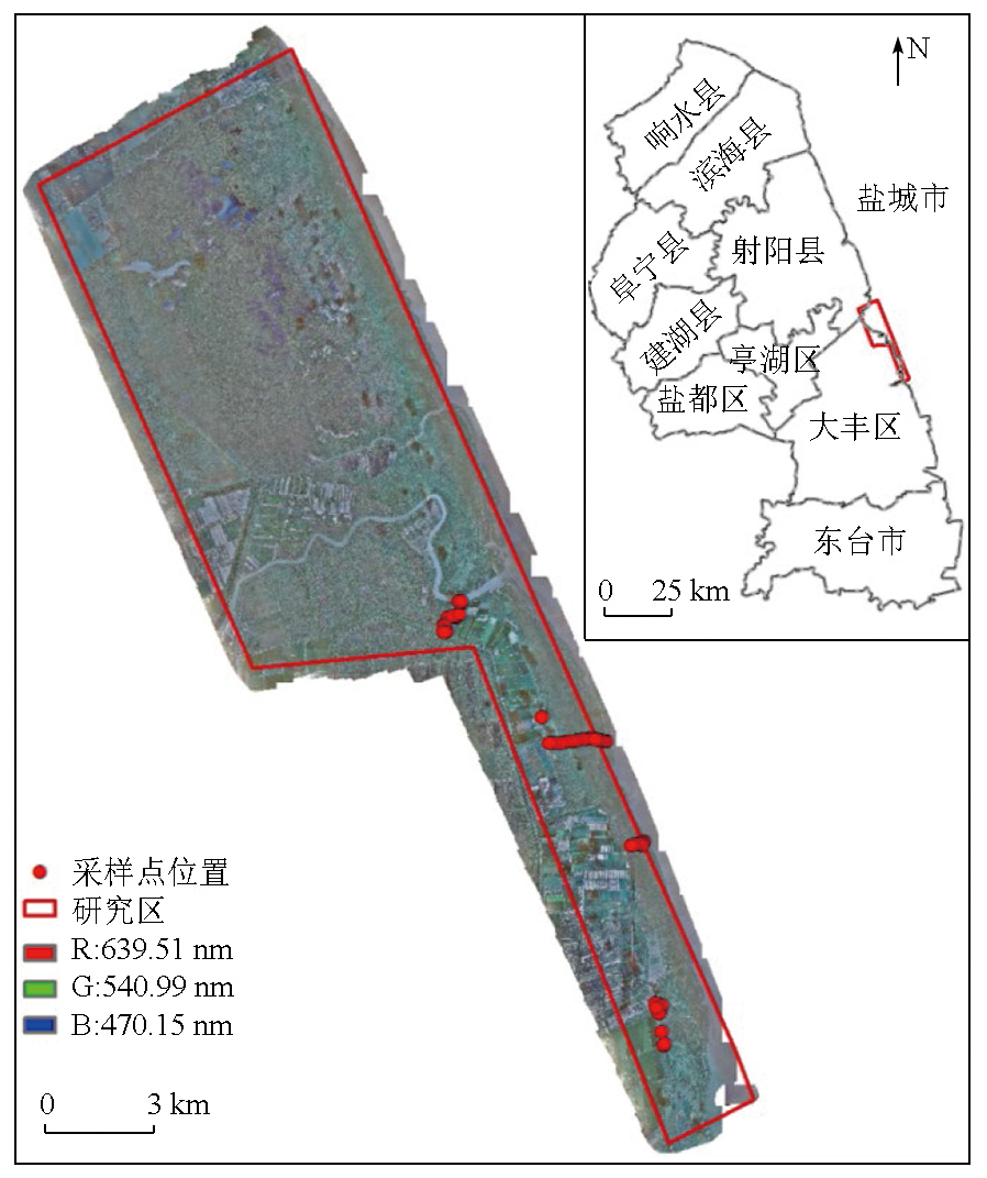
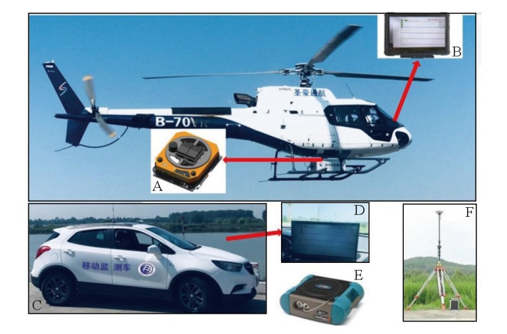
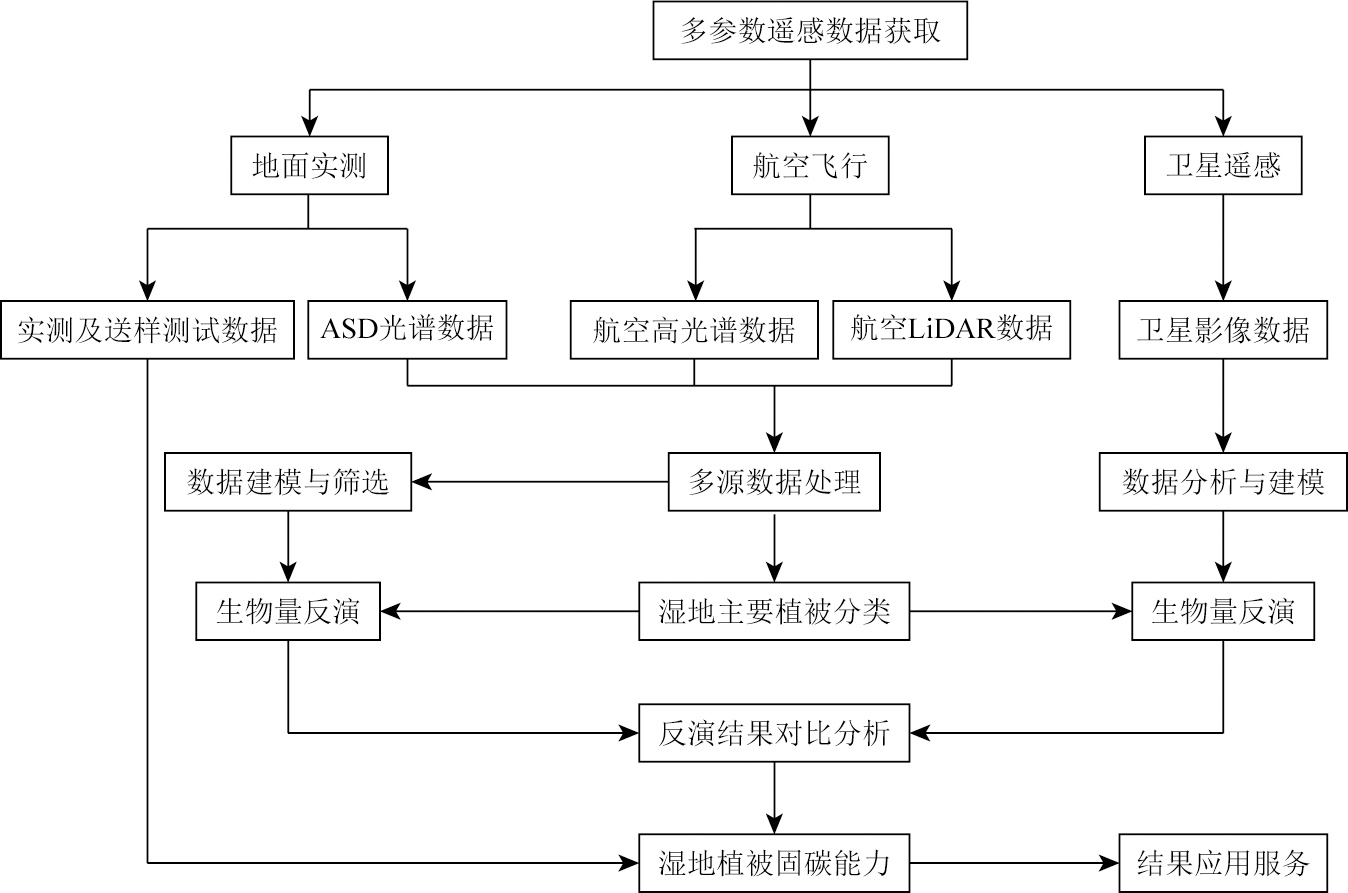
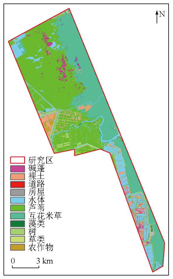
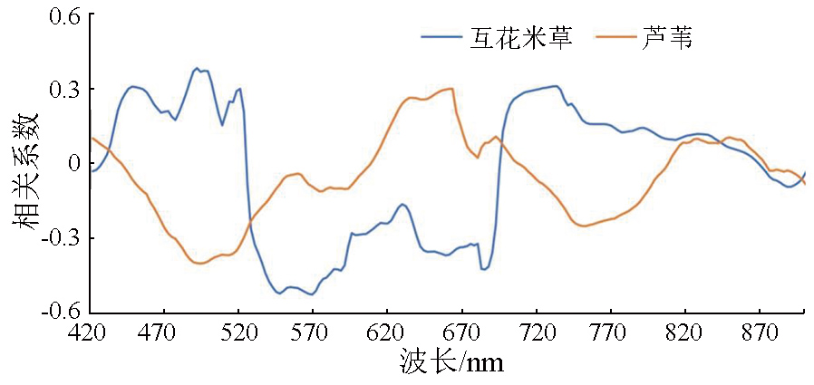
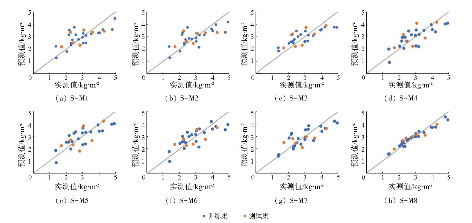
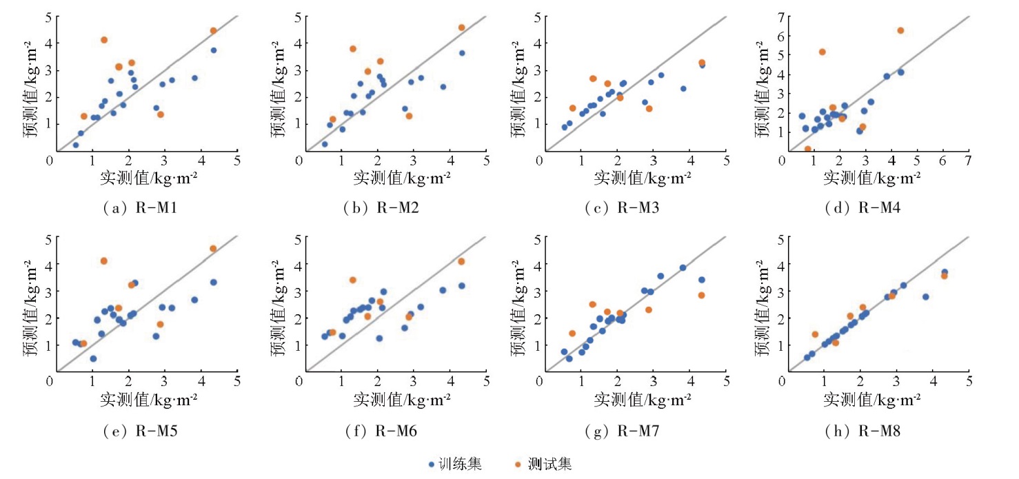
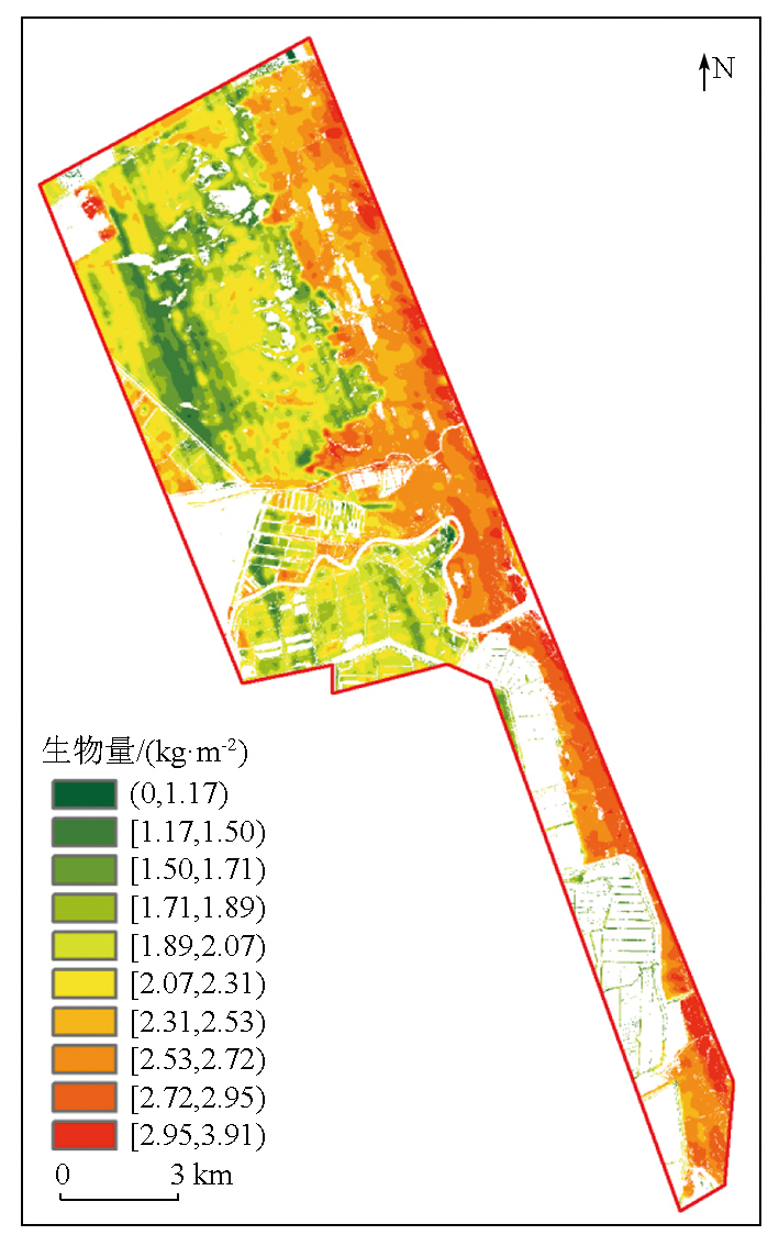
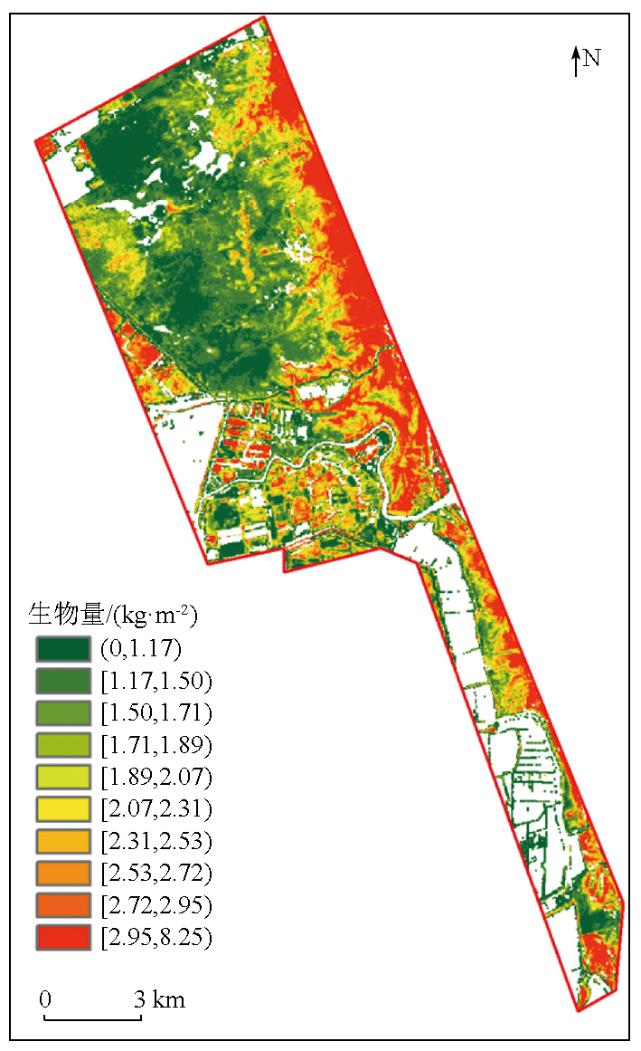
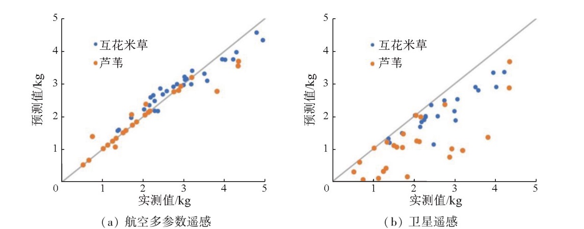
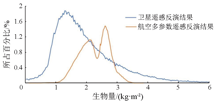
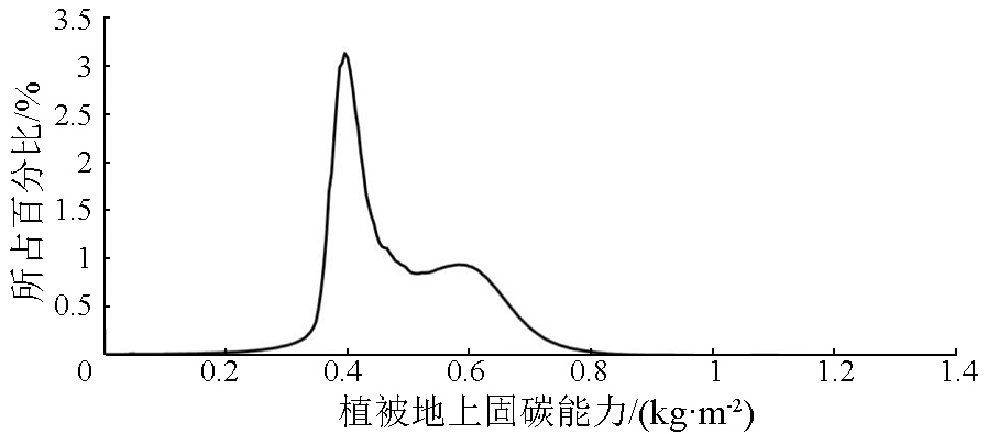
Abstract This study investigated the coastal wetland of Jiangsu Province. Using methods such as satellite remote sensing and airborne multi-parameter remote sensing, this study estimated the biomass of dominant plants and estimated their carbon sequestration capacities. Based on fine-scale classification of surface features achieved using airborne hyperspectral data, this study extracted 11 land cover types. The vegetation cover was approximately 76%, and zones with human activities accounted for about 1.5% of the study area. The model for vegetation biomass inversion using the multi-parameter airborne remote sensing demonstrated higher accuracy than that based on satellite remote sensing, with a coefficient of determination (R2) greater than 0.8 and a root mean square error (RMSE) of 0.25. As calculated using the multi-parameter airborne remote sensing, Spartina alterniflora and reed within the study area exhibited aboveground carbon sequestration capacities of 0.41 kg/m2 and 0.58 kg/m2, respectively. This study demonstrates that the multi-parameter airborne remote sensing method can accurately determine vegetation types in wetlands and carbon sequestration capacity, thus providing crucial assessment parameters for research on the carbon cycle of the ecosystem and the current status of habitats within wetlands and precisely serving wetland resource surveys.
|
| Keywords
airborne hyperspectral remote sensing
airborne multi-parameter remote sensing
carbon sequestration capacity
aboveground biomass
remote sensing
|
|
|
|
Issue Date: 03 September 2025
|
|
|
| [1] |
曹磊, 宋金明, 李学刚, 等. 中国滨海盐沼湿地碳收支与碳循环过程研究进展[J]. 生态学报, 2013, 33(17):5141-5152.
|
| [1] |
Cao L, Song J M, Li X G, et al. Research progresses in carbon budget and carbon cycle of the coastal salt marshes in China[J]. Acta Ecologica Sinica, 2013, 33(17):5141-5152.
|
| [2] |
杨谦敏, 袁丹萍, 邓存宝, 等. 碳中和背景下植物净固碳能力研究进展[J]. 生态学杂志, 2023, 42(6):1484-1496.
|
| [2] |
Yang Q M, Yuan D P, Deng C B, et al. Research progress on net carbon sequestration capacity of plants under the background of carbon neutralization[J]. Chinese Journal of Ecology, 2023, 42(6):1484-1496.
|
| [3] |
叶思源, 赵广明, 裴绍峰, 等. 滨海湿地固碳能力评价技术与方法[M]. 武汉: 中国地质大学出版社, 2016:42-48.
|
| [3] |
Ye S Y, Zhao G M, Pei S F, et al. Evaluation technology and method of carbon sequestration capacity of coastal wetlands[M]. Wuhan: China University of Geosciences Press, 2016:42-48.
|
| [4] |
崔丽娟, 马琼芳, 宋洪涛, 等. 湿地生态系统碳储量估算方法综述[J]. 生态学杂志, 2012, 31(10):2673-2680.
|
| [4] |
Cui L J, Ma Q F, Song H T, et al. Estimation methods of wetland ecosystem carbon storage:A review[J]. Chinese Journal of Ecology, 2012, 31(10):2673-2680.
|
| [5] |
赵天舸, 于瑞宏, 张志磊, 等. 湿地植被地上生物量遥感估算方法研究进展[J]. 生态学杂志, 2016, 35(7):1936-1946.
|
| [5] |
Zhao T G, Yu R H, Zhang Z L, et al. Estimation of wetland vegetation aboveground biomass based on remote sensing data:A review[J]. Chinese Journal of Ecology, 2016, 35(7):1936-1946.
|
| [6] |
Aslan A, Rahman A F, Warren M W, et al. Mapping spatial distribution and biomass of coastal wetland vegetation in Indonesian Papua by combining active and passive remotely sensed data[J]. Remote Sensing of Environment, 2016, 183:65-81.
|
| [7] |
柴颖, 阮仁宗, 柴国武, 等. 基于光谱特征的湿地植物种类识别[J]. 国土资源遥感, 2016, 28(3):86-90.doi:10.6046/gtzyyg.2016.03.14.
|
| [7] |
Chai Y, Ruan R Z, Chai G W, et al. Species identification of wetland vegetation based on spectral characteristics[J]. Remote Sens-ing for Land and Resources, 2016, 28(3):86-90.doi: 10.6046/gtzyyg.2016.03.14.
|
| [8] |
Pride M, Priscilla M T, Gara T. Dominant wetland vegetation species discrimination and quantification using in situ hyperspectral data[J]. Transactions of the Royal Society of South Africa, 2020, 75(3):229-238.
|
| [9] |
Ecarnot M, Compan F, Roumet P. Assessing leaf nitrogen content and leaf mass per unit area of wheat in the field throughout plant cycle with a portable spectrometer[J]. Field Crops Research, 2013, 140:44-50.
|
| [10] |
Estornell J, Ruiz L A, Velázquez-Martí B, et al. Estimation of shrub biomass by airborne LiDAR data in small forest stands[J]. Forest Ecology and Management, 2011, 262(9):1697-1703.
|
| [11] |
Swatantran A, Dubayah R, Roberts D, et al. Mapping biomass and stress in the Sierra Nevada using LiDAR and hyperspectral data fusion[J]. Remote Sensing of Environment, 2011, 115(11):2917-2930.
|
| [12] |
虞海英. 融合机载LiDAR和高光谱数据的滨海湿生植被生物量反演方法研究[D]. 北京: 中国测绘科学研究院, 2015.
|
| [12] |
Yu H Y. Research on estimation of coastal wetland vegetation above-ground biomass with airborne hyperspectral and LiDAR data[D]. Beijing: Chinese Academy of Surveying and Mapping, 2015.
|
| [13] |
Luo S Z, Wang C, Xi X H, et al. Retrieving aboveground biomass of wetland Phragmites australis (common reed) using a combination of airborne discrete-return LiDAR and hyperspectral data[J]. International Journal of Applied Earth Observation and Geoinformation, 2017, 58:107-117.
|
| [14] |
杨思睿, 薛朝辉, 张玲, 等. 高光谱与LiDAR数据融合研究——以黑河中游张掖绿洲农业区精细作物分类为例[J]. 国土资源遥感, 2018, 30(4):33-40.doi:10.6046/gtzyyg.2018.04.06.
|
| [14] |
Yang S R, Xue Z H, Zhang L, et al. Fusion of hyperspectral and LiDAR data:A case study for refined crop classification in agricul-tural region of Zhangye Oasis in the middle reaches of Heihe River[J]. Remote Sensing for Land and Resources, 2018, 30(4):33-40.doi:10.6046/gtzyyg.2018.04.06.
|
| [15] |
Pang Y, Li Z Y. Subtropical forest biomass estimation using airborne LiDAR and hyperspectral data[J]. The International Archives of the Photogrammety,Remote Sensing and Spatial Information Sciences, 2016, XLI-B8:747-749.
|
| [16] |
Latifi H, Fassnacht F, Koch B. Forest structure modeling with combined airborne hyperspectral and LiDAR data[J]. Remote Sensing of Environment, 2012, 121:10-25.
|
| [17] |
Wang J, Liu Z, Yu H, et al. Mapping Spartina alterniflora biomass using LiDAR and hyperspectral data[J]. Remote Sensing, 2017, 9(6):589.
|
| [18] |
Jensen D, Cavanaugh K C, Simard M, et al. Integrating imaging spectrometer and synthetic aperture radar data for estimating wetland vegetation aboveground biomass in coastal Louisiana[J]. Remote Sensing, 2019, 11(21):2533.
|
| [19] |
赵燕红, 侯鹏, 蒋金豹, 等. 植被生态遥感参数定量反演研究方法进展[J]. 遥感学报, 2021, 25(11):2173-2197.
|
| [19] |
Zhao Y H, Hou P, Jiang J B, et al. Progress in quantitative inversion of vegetation ecological remote sensing parameters[J]. National Remote Sensing Bulletin, 2021, 25(11):2173-2197.
|
| [20] |
He L, Li A, Yin G, et al. Retrieval of grassland aboveground biomass through inversion of the PROSAIL model with MODIS imagery[J]. Remote Sensing, 2019, 11(13):1597.
|
| [21] |
孙凤娟, 居为民, 方美红, 等. 基于四尺度几何光学模型的森林地上生物量遥感估算[J]. 遥感技术与应用, 2018, 33(6):1046-1055.
|
| [21] |
Sun F J, Ju W M, Fang M H, et al. Retrieval of forest above ground biomass using 4-scale geometrical optical model and remote sens-ing data[J]. Remote Sensing Technology and Application, 2018, 33(6):1046-1055.
|
| [22] |
Wan R R, Wang P, Wang X L, et al. Mapping aboveground biomass of four typical vegetation types in the Poyang Lake wetlands based on random forest modelling and landsat images[J]. Frontiers in Plant Science, 2019, 10:1281.
|
| [23] |
苟芳珍, 赵成章, 杨俊仓, 等. 苏干湖湿地植被地上生物量空间格局及其对水盐的响应[J]. 生态学报, 2021, 41(19):7774-7784.
|
| [23] |
Gou F Z, Zhao C Z, Yang J C, et al. Spatial heterogeneity of above-ground biomass in Sugan Lake wetland vegetation[J]. Acta Ecolo-gica Sinica, 2021, 41(19):7774-7784.
|
| [24] |
Yang S X, Feng Q S, Liang T G, et al. Modeling grassland above-ground biomass based on artificial neural network and remote sens-ing in the Three-River Headwaters Region[J]. Remote Sensing of Environment, 2018, 204:448-455.
|
| [25] |
邹乐, 李欢, 章家保, 等. 滨海湿地植被地上生物量遥感反演[J]. 生态学报, 2023, 43(20):8532-8543.
|
| [25] |
Zou Y, Li H, Zhang J B, et al. Inversion of aboveground biomass of saltmarshes in coastal wetland using remote sensing[J]. Acta Ecologica Sinica, 2023, 43(20):8532-8543.
|
| [26] |
孙世泽, 汪传建, 尹小君, 等. 无人机多光谱影像的天然草地生物量估算[J]. 遥感学报, 2018, 22(5):848-856.
|
| [26] |
Sun S Z, Wang C J, Yin X J, et al. Estimating aboveground biomass of natural grassland based on multispectral images of unmanned aerial vehicles[J]. Journal of Remote Sensing, 2018, 22(5):848-856.
|
| [27] |
康孝岩, 张爱武, 庞海洋. 基于光谱重建优化的无人机高光谱影像估算牧草生物量[J]. 光谱学与光谱分析, 2021, 41(1):250-256.
|
| [27] |
Kang X Y, Zhang A W, Pang H Y. Estimation of grassland aboveground biomass from UAV-mounted hyperspectral image by optimized spectral reconstruction[J]. Spectroscopy and Spectral Analysis, 2021, 41(1):250-256.
|
| [28] |
张华兵, 刘红玉, 郝敬锋, 等. 自然和人工管理驱动下盐城海滨湿地景观格局演变特征与空间差异[J]. 生态学报, 2012, 32(1):101-110.
|
| [28] |
Zhang H B, Liu H Y, Hao J F, et al. Spatiotemporal characteristics of landscape change in the coastal wetlands of Yancheng caused by natural processes and human activities[J]. Acta Ecologica Sinica, 2012, 32(1):101-110.
|
| [29] |
修连存, 郑志忠, 杨彬, 等. 机载高光谱成像技术在长江经济带苏、皖、浙地区生态环境保护中的应用[J]. 中国地质, 2021, 48(5):1334-1356.
|
| [29] |
Xiu L C, Zheng Z Z, Yang B, et al. Application of airborne hyperspectral imaging technology to the ecological environment protection of Jiangsu,Anhui and Zhejiang Provinces at Yangtze River Economic Belt[J]. Geology in China, 2021, 48(5):1334-1356.
|
| [30] |
徐明钻, 梁森, 石剑龙, 等. 航空高光谱反演耕地土壤重金属分布特征——以苏北灌河地区为例[J]. 华东地质, 2021, 42(1):100-107.
|
| [30] |
Xu M Z, Liang S, Shi J L, et al. Airborne hyperspectral inversion of heavy metal distribution in cultivated soil:A case study of the Guanhe Area,North Jiangsu Province[J]. East China Geology, 2021, 42(1):100-107.
|
| [31] |
何晓群, 刘文卿. 应用回归分析(第5版)[M]. 北京: 中国人民大学出版社, 2019:137-145.
|
| [31] |
He X Q, Liu W Q. Applied regression analysis (5th edition)[M]. Beijing: China Renmin University Press, 2019:137-145.
|
| [32] |
王惠文, 吴载斌, 孟洁. 偏最小二乘回归的线性与非线性方法[M]. 北京: 国防工业出版社, 2006:42-59.
|
| [32] |
Wang H W, Wu Z B, Meng J. Partial least-squares regression:Linear and nonlinear methods[M]. Beijing: National Defense Industry Press, 2006:42-59.
|
| [33] |
Smola A J, Schölkopf B. A tutorial on support vector regression[J]. Statistics and Computing, 2004, 14(3):199-222.
|
|
Viewed |
|
|
|
Full text
|
|
|
|
|
Abstract
|
|
|
|
|
Cited |
|
|
|
|
| |
Shared |
|
|
|
|
| |
Discussed |
|
|
|
|
 2025,
Vol. 37
2025,
Vol. 37