|
|
 |
|

|
|
|
Remote sensing-based dynamic monitoring and ecological restoration effect assessment of abandoned open-pit mines in the Yangtze River economic belt within Hubei Province |
SUN Yaqin1,2,3( ), DI Baogang4, XING Yu1, AN Na1(), ZHANG Xian1 ), DI Baogang4, XING Yu1, AN Na1(), ZHANG Xian1 |
1. China Aero Geophysical Survey and Remote Sensing Center for Natural Resources, Beijing 100083, China
2. Key Laboratory of Airborne Geophysics and Remote Sensing Geology, Ministry of Nature Resources, Beijing 100083, China
3. Technology Innovation Center for Geohazards Identification and Monitoring with Earth Observation System, Ministry of Natural Resources of the People’s Republic of China, Beijing 100083, China
4. China Siwei Surveying and Mapping Technology Co., Ltd., Beijing 100083, China |
|
|
|
|
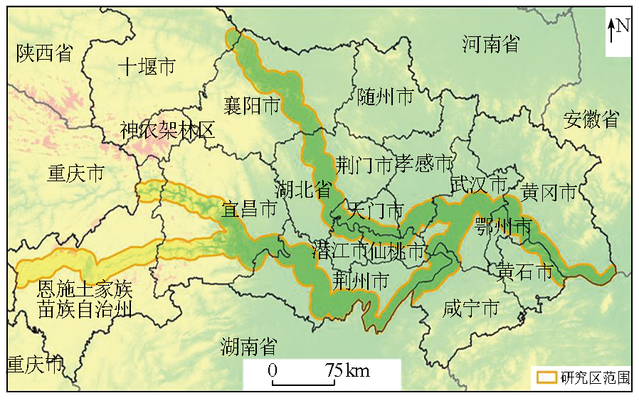
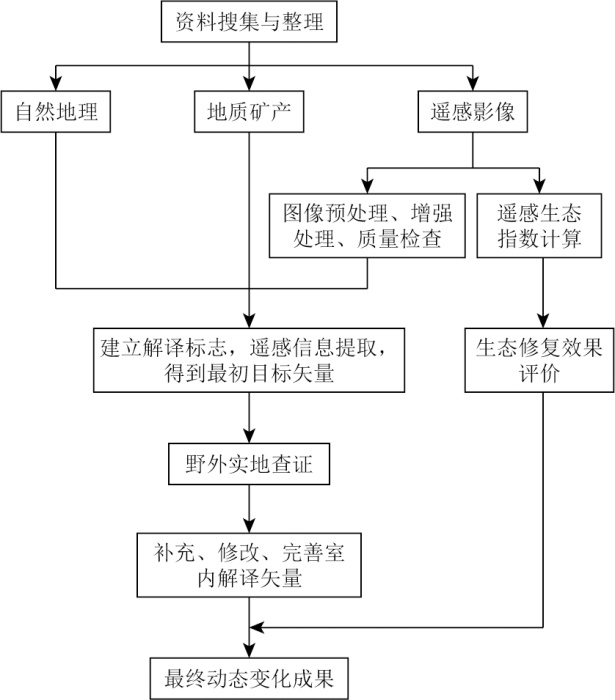
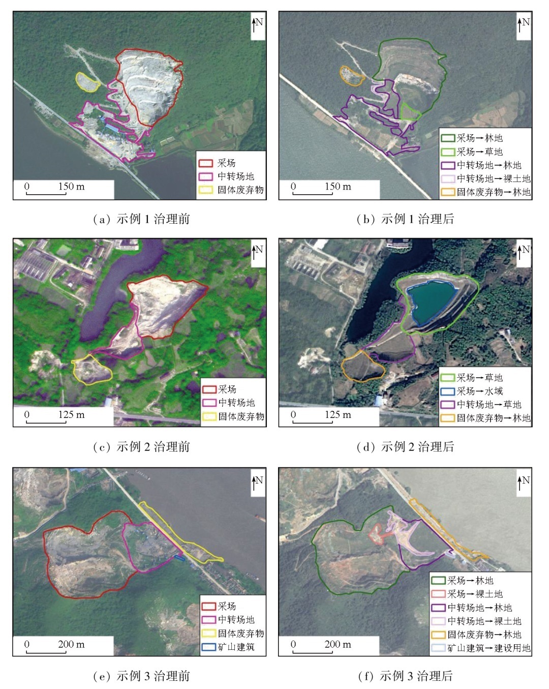
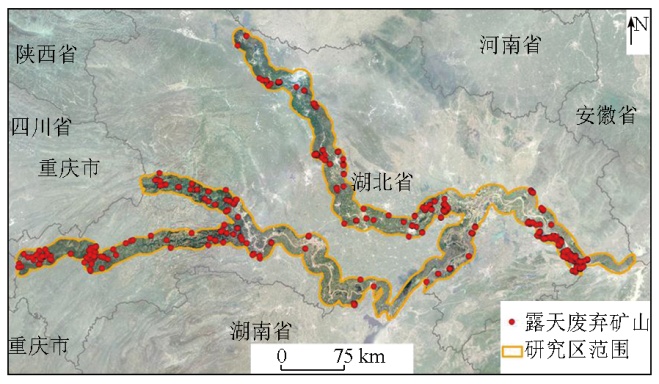
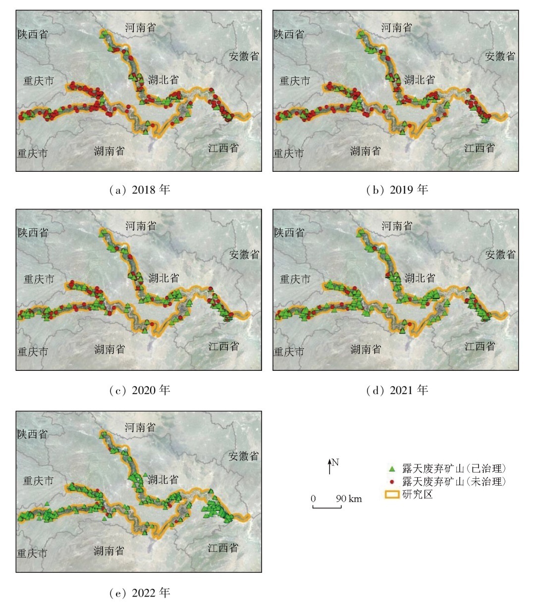
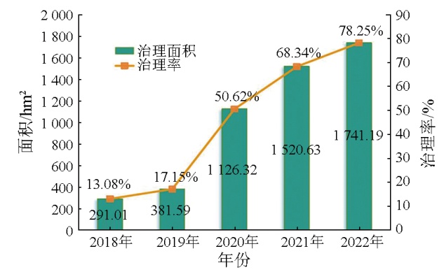
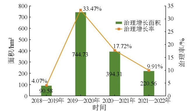
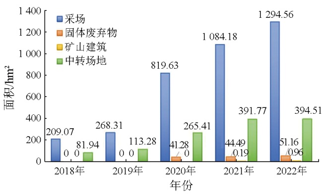
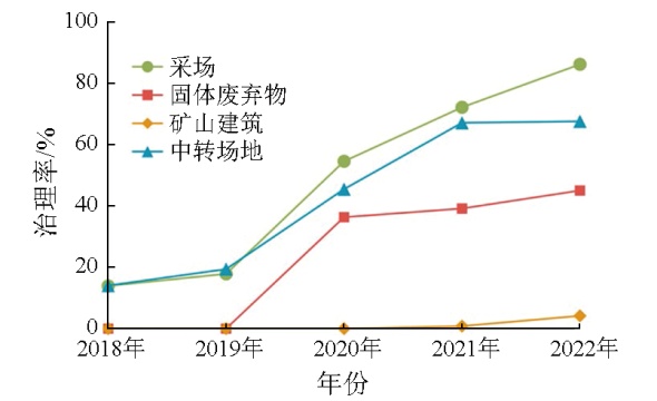
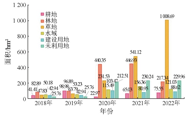
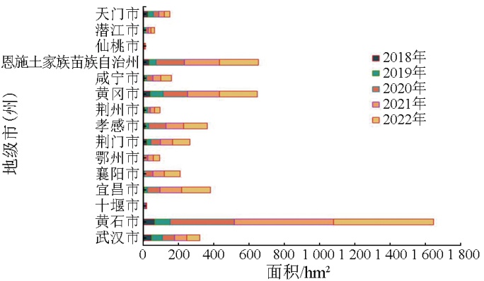
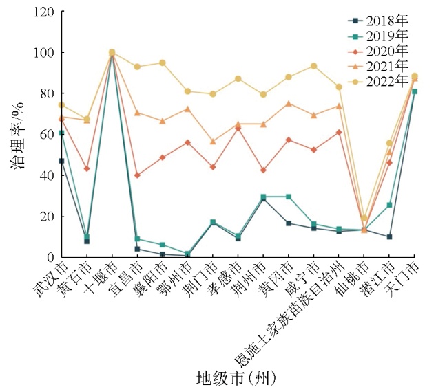
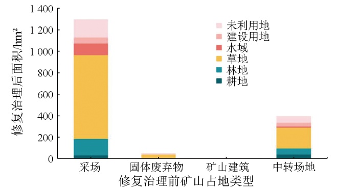
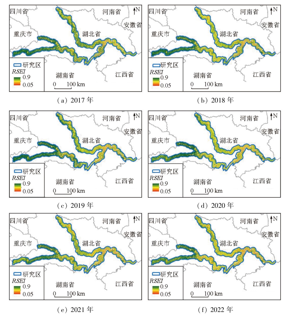
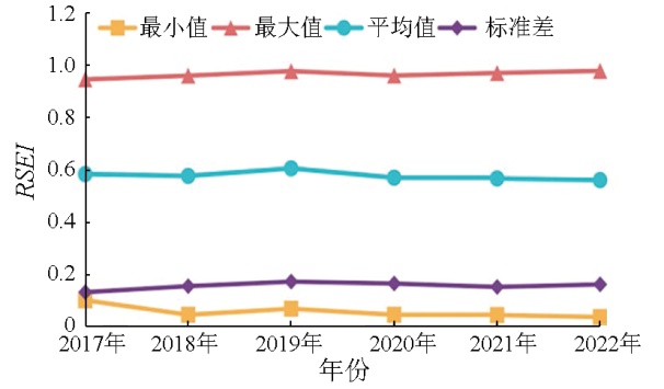
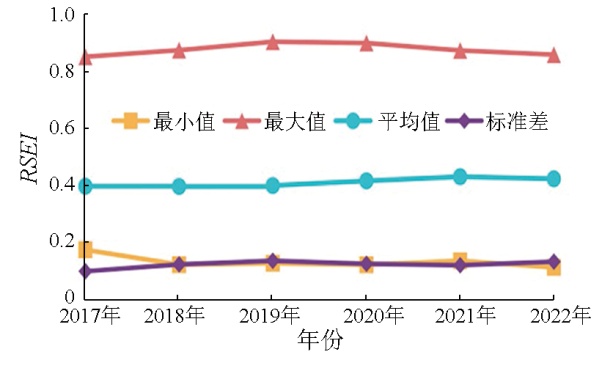
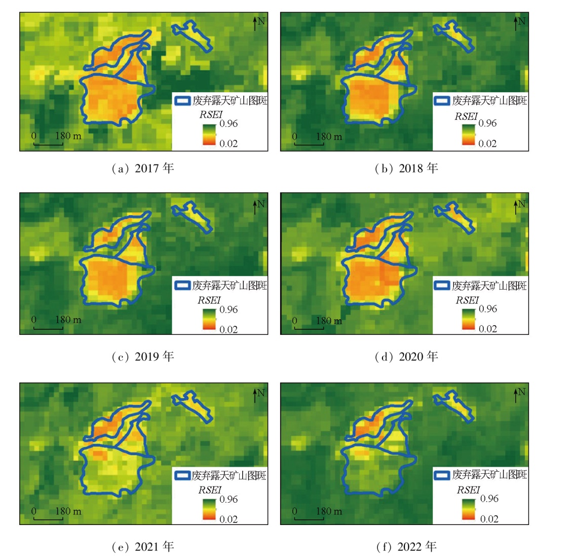
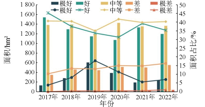
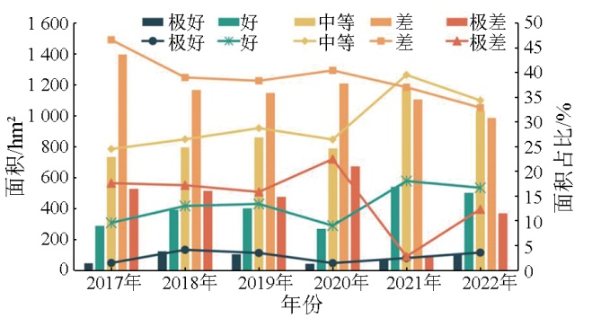
Abstract The Yangtze River economic belt (YREB), spanning the east, middle, and west regions of China, serves as a pioneering demonstration belt for the construction of ecological civilization. Hubei Province, a member of the YREB, holds abundant mineral resources. Its long-term exploitation of mineral resources has caused ecosystem damage and social stability disruption, necessitating ecological restoration of abandoned open-pit mines. However, few studies concern the systematic tracking, monitoring, and analysis of the ecological restoration of abandoned open-pit mines in the YREB within Hubei Province. Based on the remote sensing data from the domestic high-resolution satellite from 2017 to 2022, and utilizing human-computer interaction interpretation, this study monitored the distributions and ecological restoration of abandoned open-pit mines within 10 km on both sides of the mainstems and major tributaries (Hanjiang River and Qingjiang River) in the YREB within Hubei Province. The results indicate that by the end of 2017, 537 patches of abandoned open-pit mines had been identified in the study area, involving 283 mines with a total area of 2 225.19 hm2. The monitoring results of dynamic changes from 2018 to 2022 show that the ecological restoration and treatment area of abandoned open-pit mines increased from 291.01 hm2 in 2018 to 1 741.19 hm2 in 2022, manifesting a continuously rising treatment rate, suggesting overall improved ecological restoration and treatment results. Using the remote sensing ecological index (RSEI) values from 2017 to 2022, this study assessed the ecological restoration effects of abandoned open-pit mines. The assessment results reveal that the average RSEI value for the patches increased from 0.397 7 in 2017 to 0.423 9 in 2022, with a growth rate of 6.59 %, suggesting significantly improved ecological conditions and restoration effects. Overall, the monitoring and assessment results of the dynamic changes in ecological restoration of abandoned open-pit mines in the study area provide valuable data and methodological insights for monitoring abandoned open-pit mines in Hubei Province and other regions in China, highlighting the significance of this study.
|
| Keywords
Yangtze River economic belt (YREB)
abandoned open-pit mine
ecological restoration
remote sensing ecological index (RSEI)
ecological restoration effect assessment
|
|
|
|
Issue Date: 01 July 2025
|
|
|
| [1] |
张进德, 郗富瑞. 我国废弃矿山生态修复研究[J]. 生态学报, 2020, 40(21):7921-7930.
|
| [1] |
Zhang J D, Xi F R. Study on ecological restoration of abandoned mines in China[J]. Acta Ecologica Sinica, 2020, 40(21):7921-7930.
|
| [2] |
关钊, 谢红彬, 罗琳, 等. 近30年中国矿业废弃地生态修复及再利用研究热点及趋势分析[J]. 中国矿业, 2022, 31(5):18-26.
|
| [2] |
Guan Z, Xie H B, Luo L, et al. Analysis of research hotspots and trends in ecological restoration and reuse of China’s mining wastelands in the past 30 years[J]. China Mining Magazine, 2022, 31(5):18-26.
|
| [3] |
Chaussard E, Kerosky S. Characterization of black sand mining activities and their environmental impacts in the Philippines using remote sensing[J]. Remote Sensing, 2016, 8(2):100.
|
| [4] |
Ranjan A K, Sahoo D, Gorai A K. Quantitative assessment of landscape transformation due to coal mining activity using earth observation satellite data in Jharsuguda coal mining region,Odisha,India[J]. Environment,Development and Sustainability, 2021, 23(3):4484-4499.
|
| [5] |
Kayet N, Pathak K, Singh C P, et al. Vegetation health conditions assessment and mapping using AVIRIS-NG hyperspectral and field spectroscopy data for-environmental impact assessment in coal mining sites[J]. Ecotoxicology and Environmental Safety, 2022,239:113650.
|
| [6] |
Li Q, Li F, Guo J, et al. The synergistic effect of topographic factors and vegetation indices on the underground coal mine utilizing unmanned aerial vehicle remote sensing[J]. International Journal of Environmental Research and Public Health, 2023, 20(4):3759.
|
| [7] |
Xu Y, Guo L, Li J, et al. Automatically identifying the vegetation destruction and restoration of various open-pit mines utilizing remotely sensed images:Auto-VDR[J]. Journal of Cleaner Production, 2023,414:137490.
|
| [8] |
Li H, Xu F, Li Q. Remote sensing monitoring of land damage and restoration in rare earth mining areas in 6 counties in southern Jiangxi based on multisource sequential images[J]. Journal of Environmental Management, 2020,267:110653.
|
| [9] |
Vorovencii I. Changes detected in the extent of surface mining and reclamation using multitemporal Landsat imagery:A case study of Jiu Valley,Romania[J]. Environmental Monitoring and Assessment, 2021, 193(1):30.
doi: 10.1007/s10661-020-08834-w
pmid: 33398530
|
| [10] |
Xiao W, Chen W, Deng X. Coupling and coordination of coal mining intensity and social-ecological resilience in China[J]. Ecological Indicators, 2021,131:108167.
|
| [11] |
Yuan D, Hu Z, Yang K, et al. Assessment of the ecological impacts of coal mining and restoration in alpine areas:A case study of the Muli Coalfield on the Qinghai-Tibet Plateau[J]. IEEE Access, 2021,9:162919-162934.
|
| [12] |
Ogunro O T, Owolabi A O. Assessment of the sustainability of landcovers due to artisanal mining in Jos Area,Nigeria[J]. Environmental Science and Pollution Research International, 2023, 30(13):36502-36520.
|
| [13] |
Cetin M, Pekkan O I, Ozturk G B, et al. Determination of the impacts of mining activities on land cover and soil organic carbon:Altintepe gold mine case,Turkey[J]. Water,Air,& Soil Pollution, 2023, 234(4):272.
|
| [14] |
Ruppen D, Runnalls J, Tshimanga R M, et al. Optical remote sen-sing of large-scale water pollution in Angola and DR Congo caused by the Catoca Mine tailings spill[J]. International Journal of Applied Earth Observation and Geoinformation, 2023,118:103237.
|
| [15] |
张浙, 卢然, 伍思扬, 等. 长江经济带矿山土壤重金属污染及健康风险评价[J]. 环境科学, 2022, 43(7):3763-3772.
|
| [15] |
Zhang Z, Lu R, Wu S Y, et al. Heavy metal pollution and health risk assessment of mine soil in Yangtze River economic belt[J]. Environmental Science, 2022, 43(7):3763-3772.
|
| [16] |
KopeĆ A, Trybała P, Głᶏbicki D, et al. Application of remote sen-sing,GIS and machine learning with geographically weighted regression in assessing the impact of hard coal mining on the natural environment[J]. Sustainability, 2020, 12(22):9338.
|
| [17] |
Liu H, Jiang Y, Misa R, et al. Ecological environment changes of mining areas around Nansi Lake with remote sensing monitoring[J]. Environmental Science and Pollution Research International, 2021, 28(32):44152-44164.
|
| [18] |
Wang Y, Zhang D, Wang Y. Evaluation analysis of forest ecological security in 11 provinces (cities) of the Yangtze River economic belt[J]. Sustainability, 2021, 13(9):4845.
|
| [19] |
方传棣. 长江经济带矿产资源开发-经济-环境耦合协调发展研究[D]. 武汉: 中国地质大学, 2019.
|
| [19] |
Fang C D. Study on the coordinated development of mineral resources development-economy-environment coupling in the Yangtze River Economic Belt[D]. Wuhan: China University of Geosciences, 2019.
|
| [20] |
李海东, 高媛赟, 燕守广. 生态保护红线区废弃矿山生态修复监管[J]. 生态与农村环境学报, 2018, 34(8):673-677.
|
| [20] |
Li H D, Gao Y Y, Yan S G. Supervisory countermeasures of ecolo-gical restoration of abandoned mine areas in the ecological conservation redline area[J]. Journal of Ecology and Rural Environment, 2018, 34(8):673-677.
|
| [21] |
乔雪园, 吴海斌, 王殿常, 等. 长江经济带矿山生态治理的实施成效、问题与对策[J]. 中国矿业, 2022, 31(8):36-43.
|
| [21] |
Qiao X Y, Wu H B, Wang D C, et al., Achievements,problems and suggestions of mine ecological governance in the Yangtze River Economic Belt[J]. China Mining Magazine, 2022, 31(8):36-43.
|
| [22] |
殷亚秋, 杨金中, 汪洁, 等. 长江经济带废弃矿山占损土地遥感调查与生态修复对策[J]. 国土资源遥感, 2020, 32(2):170-176.doi:10.6046/gtzyyg.2020.02.22.
|
| [22] |
Yin Y Q, Yang J Z, Wang J, et al. Remote sensing survey of land occupied and damaged by abandoned mines along the Yangtze River Economic Belt and researchron ecological remediation countermeasures[J]. Remote Sensing for Natural Resources, 2020, 32(2):170-176.doi:10.6046/gtzyyg.2020.02.22.
|
| [23] |
孙娅琴, 邸宝刚, 安娜, 等. 长江经济带废弃露天矿山生态修复典型模式遥感监测:以湖北省为例[J]. 中国矿业, 2022, 31(12):50-57,63.
|
| [23] |
Sun Y Q, Di B G, An N, et al. Remote sensing monitoring of typical ecological restoration models of abandoned open-pit mines in the Yangtze River Economic Belt:A case study of Hubei Province[J]. China Mining Magazine, 2022, 31(12):50-57,63.
|
| [24] |
Du S, Li W, Li J, et al. Open-pit mine change detection from high resolution remote sensing images using DA-UNet++ and object-based approach[J]. International Journal of Mining,Reclamation and Environment, 2022, 36(7):512-535.
|
| [25] |
唐晖, 邹娟, 尹向红, 等. 基于高分遥感的洞庭湖区河湖采砂监管及典型案例分析[J]. 自然资源遥感, 2023, 35(3):302-309.doi:10.6046/zrzyyg.2023075.
|
| [25] |
Tang H, Zou J, Yin X H, et al. River and lake sand mining in the Dongting Lake area:Supervision based on high-resolution remote sensing images and typical case analysis[J]. Remote Sensing for Natural Resources, 2023, 35(3):302-309.doi:10.6046/zrzyyg.2023075.
|
| [26] |
赵玉灵, 杨金中, 孙娅琴, 等. 油气矿山越界开采遥感监测方法探索[J]. 自然资源遥感, 2022, 34(2):30-36.doi:10.6046/zrzyyg.2021140.
|
| [26] |
Zhao Y L, Yang J Z, Sun Y Q, et al. A remote sensing method for judging the cross-border mining of oil and gas mines[J]. Remote Sensing for Natural Resources, 2022, 34(2):30-36.doi:10.6046/zrzyyg.2021140.
|
| [27] |
高俊华, 邹联学, 龙欢, 等. 基于遥感动态监测的吉林省矿山地质环境及生态修复变化特征分析[J]. 自然资源遥感, 2022, 34(3):240-248.doi:10.6046/zrzyyg.2021078.
|
| [27] |
Gao J H, Zou l X, Long H, et al. Analysis on characteristics of mine geological environment and ecologicarestoration changes in Jilin Province based on dynamic remote sensing monitoring[J]. Remote Sensing for Natural Resources, 2022, 34(3):240-248.doi:10.6046/zrzyyg.2021078
|
| [28] |
Wang W, Liu R, Gan F, et al. Monitoring and evaluating restoration vegetation status in mine region using remote sensing data:Case study in Inner Mongolia,China[J]. Remote Sensing, 2021, 13(7):1350.
|
| [29] |
Liu Y, Heng W, Yue H. Quantifying the coal mining impact on the ecological environment of Gobi open-pit mines[J]. Science of the Total Environment, 2023,883:163723.
|
| [30] |
Messer L C, Jagai J S, Rappazzo K M, et al. Construction of an environmental quality index for public health research[J]. Environmental Health:A Global Access Science Source, 2014, 13(1):39.
|
| [31] |
Liao X, Li W, Hou J. Application of GIS based ecological vulnerability evaluation in environmental impact assessment of master plan of coal mining area[J]. Procedia Environmental Sciences, 2013,18:271-276.
|
| [32] |
徐涵秋. 城市遥感生态指数的创建及其应用[J]. 生态学报, 2013, 33(24):7853-7862.
|
| [32] |
Xu H Q. A remote sensing urban ecological index and its application[J]. Acta Ecologica Sinica, 2013, 33(24):7853-7862.
|
| [33] |
Dai X, Li W, Liu Z, et al. Effects of mining on urban environmental change:A case study of Panzhihua[J]. Remote Sensing, 2022, 14(23):6004.
|
| [34] |
Tang H, Fang J, Xie R, et al. Impact of land cover change on a typical mining region and its ecological environment quality evaluation using remote sensing based ecological index (RSEI)[J]. Sustainability, 2022, 14(19):12694.
|
| [35] |
Shan Y, Dai X, Li W, et al. Detecting spatial-temporal changes of urban environment quality by remote sensing-based ecological indices:A case study in Panzhihua City,Sichuan Province,China[J]. Remote Sensing, 2022, 14(17):4137.
|
| [36] |
Wei Y, Qian J, Fan W, et al. Dynamic monitoring of ecological environment quality in Lijiang River Basin based on RSEI[J]. Science of Soil and Water Conservation, 2021, 19(1):122-131.
|
| [37] |
梅安新. 遥感导论[M]. 北京: 高等教育出版社, 2001.
|
| [37] |
Mei A X. An introduction to remote sensing[M]. Beijing: Higher Education Press, 2001.
|
| [38] |
徐涵秋, 邓文慧. MRSEI指数的合理性分析及其与RSEI指数的区别[J]. 遥感技术与应用, 2022, 37(1):1-7.
doi: 10.11873/j.issn.1004-0323.2022.1.0001
|
| [38] |
Xu H Q, Deng W H. Rationality analysis of MRSEI and its difference with RSEI[J]. Remote Sensing Technology and Application, 2022, 37(1):1-7.
|
|
Viewed |
|
|
|
Full text
|
|
|
|
|
Abstract
|
|
|
|
|
Cited |
|
|
|
|
| |
Shared |
|
|
|
|
| |
Discussed |
|
|
|
|
 2025,
Vol. 37
2025,
Vol. 37