|
|
 |
|

|
|
|
Monitoring and analysis of new mining-destroyed land and land restoration and management in Shandong Province in 2021 |
ZHAO Lijun1,2( ), LIU Huan1,2(), ZHANG Yun1,2, YANG Junquan1,2, WANG Wei1,2, CHEN Donglei1,2 ), LIU Huan1,2(), ZHANG Yun1,2, YANG Junquan1,2, WANG Wei1,2, CHEN Donglei1,2 |
1. Tianjin Centre of Geological Survey, China Geological Survey, Tianjin 300170, China
2. North China Center for Geoscience Innovation, China Geological Survey, Tianjin 300170, China |
|
|
|
|
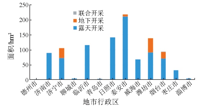
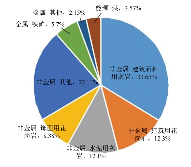
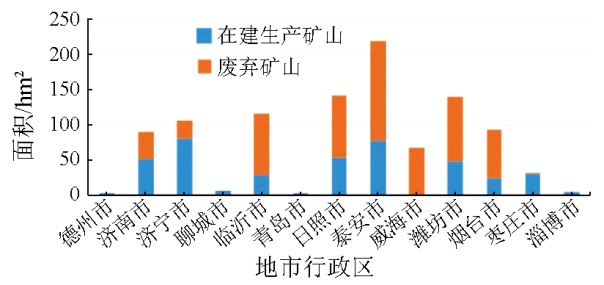
Abstract Timely and accurate monitoring and analysis of land for mine development and associated restoration and management is a principal task in remote sensing survey and monitoring of mine environments. Hence, using high-spatial-resolution remote sensing data as primary data source, this study delineated the new mining-destroyed land area (558.07 hm2) and land restoration and management area (1 019.07 hm2, including artificially restored 975.29 hm2 and naturally restored 43.78 hm2) in Shandong Province in 2021. Additionally, there were 26.59 hm2 of destroyed land due to infrastructure and road construction and 77.03 hm2 of tailings pond management. By preliminarily analyzing the remote sensing work concerning the new mining-destroyed land and land restoration and management in Shandong Province in 2021, this study proposed countermeasures and suggestions for existing problems. The investigation and monitoring results can effectively support the scientific decision-making of land management departments in Shandong Province.
|
| Keywords
mining-destroyed land
land restoration and management
remote sensing monitoring
Shandong Province
|
|
|
|
Issue Date: 01 July 2025
|
|
|
| [1] |
杨金中, 许文佳, 姚维岭, 等. 全国采矿损毁土地分布与治理状况及存在问题[J]. 地学前缘, 2021, 28(4):83-89.
doi: 10.13745/j.esf.sf.2020.10.8
|
| [1] |
Yang J Z, Xu W J, Yao W L, et al. Land destroyed by mining in China:Damagedistribution,rehabilitation status and existing problems[J]. Earth Science Frontiers, 2021, 28(4):83-89.
|
| [2] |
杨金中, 秦绪文, 聂洪峰, 等. 全国重点矿区矿山遥感监测综合研究[J]. 中国地质调查, 2015, 2(4):24-30.
|
| [2] |
Yang J Z, Qin X W, Nie H F, et al. Comprehensive research on remote sensing monitoring of the national concentration zones of the important mine[J]. Geological Survey of China, 2015, 2(4):24-30.
|
| [3] |
杨金中, 聂洪峰, 荆青青. 初论全国矿山地质环境现状与存在问题[J]. 国土资源遥感, 2017, 29(2):1-7.doi:10.6046/gtzyyg.2017.02.01.
|
| [3] |
Yang J Z, Nie H F, Jing Q Q. Preliminary analysis of mine geo-environment status and existing problems in China[J]. Remote Sen-sing for Natural Resources, 2017, 29(2):1-7.doi:10.6046/gtzyyg.2017.02.01.
|
| [4] |
柴永昌. 山东省几种优势非金属矿产的开发利用现状及其发展前景[J]. 山东地质, 1999, 15(4):50-55.
|
| [4] |
Chai Y C. Present development and utilization of nonmetallic mineral resources and their developing future in Shandong[J]. Geology of Shandong, 1999, 15(4):50-55.
|
| [5] |
郑雄伟, 彭孛, 尚坤. 基于国产卫星的遥感地质解译能力评估[J]. 自然资源遥感, 2021(3):1-10.doi:10.6046/zrzyyg.2020357.
|
| [5] |
Zheng X W, Peng B, Shang K. Assessment of the interpretation ability of domestic satellites in geological remote sensing[J]. Remote Sensing for Natural Resources, 2021(3):1-10.doi:10.6046/zrzyyg.2020357.
|
| [6] |
孔卓, 杨海涛, 郑逢杰, 等. 高光谱遥感图像大气校正研究进展[J]. 自然资源遥感, 2022, 34(4):1-10.doi:10.6046/zrzyyg.2021371.
|
| [6] |
Kong Z, Yang H T, Zheng F J, et al. Research advances in atmospheric correction of hyperspectral remote sensing images[J]. Remote Sensing for Natural Resources, 2022, 34(4):1-10.doi:10.6046/zrzyyg.2021371.
|
| [7] |
刘欢, 张云, 黄旭红, 等. 遥感技术在内蒙古自治区中西部重点矿区开采监测中的应用[J]. 华北地质, 2021, 44(4):55-60.
|
| [7] |
Liu H, Zhang Y, Huang X H, et al. Application of remote sensing technology in mining monitoring in midwest major mining area of Inner Mongolia[J]. North China Geology, 2021, 44(4):55-60.
|
| [8] |
梁晖, 杨士道. 遥感技术在蓟县北部矿山开采动态监测中的应用[J]. 地质调查与研究, 2005, 28(3):180-186.
|
| [8] |
Liang H, Yang S D. Application of remote sensing in the dynamic inspection of mining in northern Jixian[J]. Geological Survey and Research, 2005, 28(3):180-186.
|
| [9] |
马霭乃. 遥感目视解译的基本理论与方法[J]. 遥感信息, 1987, 2(3):26-29.
|
| [9] |
Ma A N. Basic theory and method of remote sensing visual interpretation[J]. Remote Sensing Information, 1987, 2(3):26-29.
|
| [10] |
张仙, 李伟, 陈理, 等. 露天开采矿区要素遥感提取研究进展及展望[J]. 自然资源遥感, 2023, 35(2):25-33.doi:10.6046/zrzyyg.2022141.
|
| [10] |
Zhang X, Li W, Chen L, et al. Research progress and prospect of remote sensing-based feature extraction of opencast mining areas[J]. Remote Sensing for Natural Resources, 2023, 35(2):25-33.doi:10.6046/zrzyyg.2022141.
|
| [11] |
黄登冕, 张聪, 姚晓军, 等. 矿山环境遥感监测研究进展[J]. 遥感技术与应用, 2022, 37(5):1043-1055.
doi: 10.11873/j.issn.1004-0323.2022.5.1043
|
| [11] |
Huang D M, Zhang C, Yao X J, et al. Research progress of mine environment remote sensing monitoring[J]. Remote Sensing Technology and Application, 2022, 37(5):1043-1055.
|
| [12] |
王建华, 李阳, 梁树能, 等. 基于高光谱卫星数据的土地沙化识别及提取研究[J]. 华北地质, 2022(4):60-67.
doi: 10.19948/j.12-1471/P.2022.04.08
|
| [12] |
Wang J H, Li Y, Liang S N, et al. The study of land desertification recognition and extraction based on hyperspectral satellite data[J]. North China Geology, 2022(4):60-67.
|
| [13] |
高俊华, 邹联学, 龙欢, 等. 基于遥感动态监测的吉林省矿山地质环境及生态修复变化特征分析[J]. 自然资源遥感, 2022, 34(3):240-248.doi:10.6046/zrzyyg.2021278.
|
| [13] |
Gao J H, Zou L X, Long H, et al. Analysis on characteristics of mine geological environment and ecological restoration changes in Jilin Province based on dynamic remote sensing monitoring[J]. Remote Sensing for Natural Resources, 2022, 34(3):240-248.doi:10.6046/zrzyyg.2021278.
|
| [14] |
唐静秋. 浅析遥感信息技术在自然资源监测监管中的应用[J]. 测绘与空间地理信息, 2022, 45(10):38-40.
|
| [14] |
Tang J Q. Exploration and application of remote sensing information technology in natural resources monitoring and supervision[J]. Geomatics & Spatial Information Technology, 2022, 45(10):38-40.
|
| [15] |
祁帅, 乔文光, 张勇. 遥感技术在内蒙古绿色矿山地质环境动态监测中的应用[J]. 测绘通报, 2021(s1):79-82.
|
| [15] |
Qi S, Qiao W G, Zhang Y. Application of remote sensing in green mine environment monitoring in the Inner Mongolia Autonomous Region[J]. Bulletin of Surveying and Mapping, 2021(s1):79-82.
|
| [16] |
中华人民共和国国土资源部. DZ/T 0266—2014 矿产资源开发遥感监测技术规范[S]. 北京: 中国标准出版社, 2014.
|
| [16] |
Ministry of Land and Resurces of the People’s Republic of China. DZ/T 0266—2014 Regulation on remote sensing monitoring of mining exploration[S]. Beijing: Standards Press of China, 2014.
|
| [17] |
修晓龙. 山西省矿山开发新增损毁土地年度监测与分析[J]. 中国矿业, 2022, 31(2):59-64.
|
| [17] |
Xiu X L. Annual monitoring and analysis of newly damaged land in mine development in Shanxi Province[J]. China Mining Magazine, 2022, 31(2):59-64.
|
|
Viewed |
|
|
|
Full text
|
|
|
|
|
Abstract
|
|
|
|
|
Cited |
|
|
|
|
| |
Shared |
|
|
|
|
| |
Discussed |
|
|
|
|
 2025,
Vol. 37
2025,
Vol. 37