|
|
 |
|

|
|
|
Land use classification of open-pit mining areas based on multi-source remote sensing time series features and convolutional neural networks |
LIU Hao1,2( ), DU Shouhang1,2(), XING Jianghe2, LI Jun2, GAO Tianlin2, YIN Chenghong2 ), DU Shouhang1,2(), XING Jianghe2, LI Jun2, GAO Tianlin2, YIN Chenghong2 |
1. Key Laboratory of Coupling Process and Effect of Natural Resources Elements, Beijing 100055, China
2. College of Geosciences and Surveying Engineering, China University of Mining and Technology (Beijing), Beijing 100083, China |
|
|
|
|
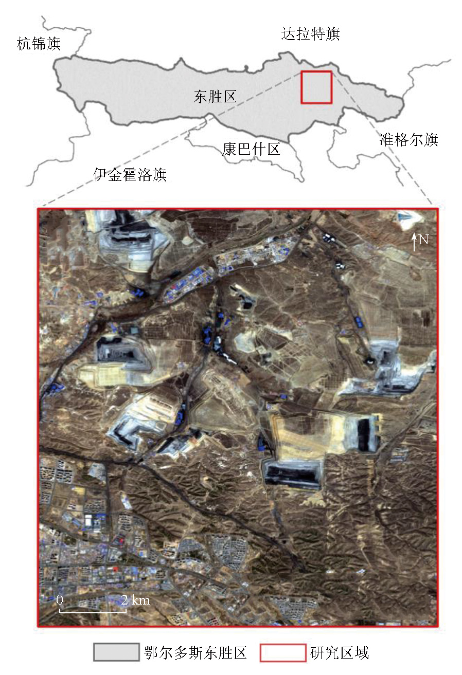
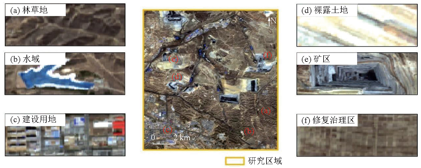
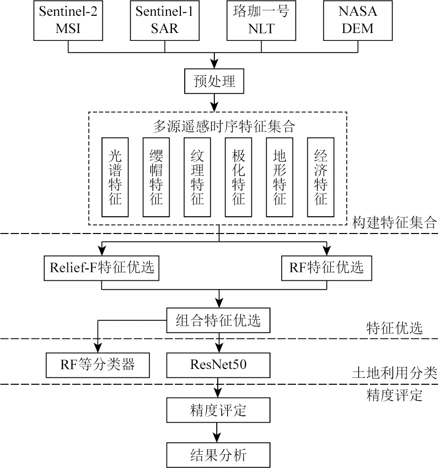
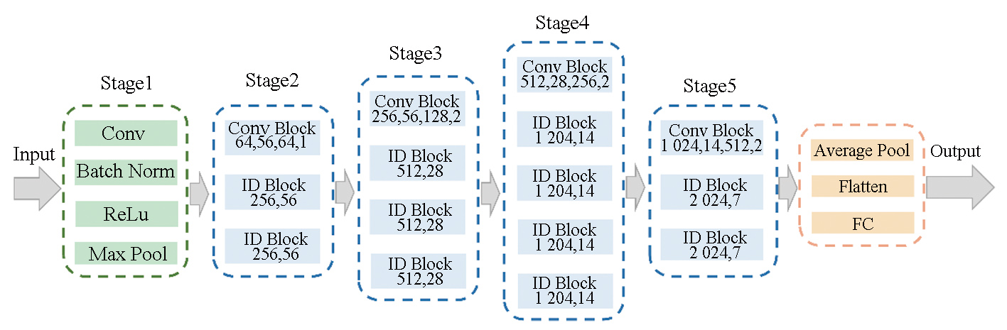
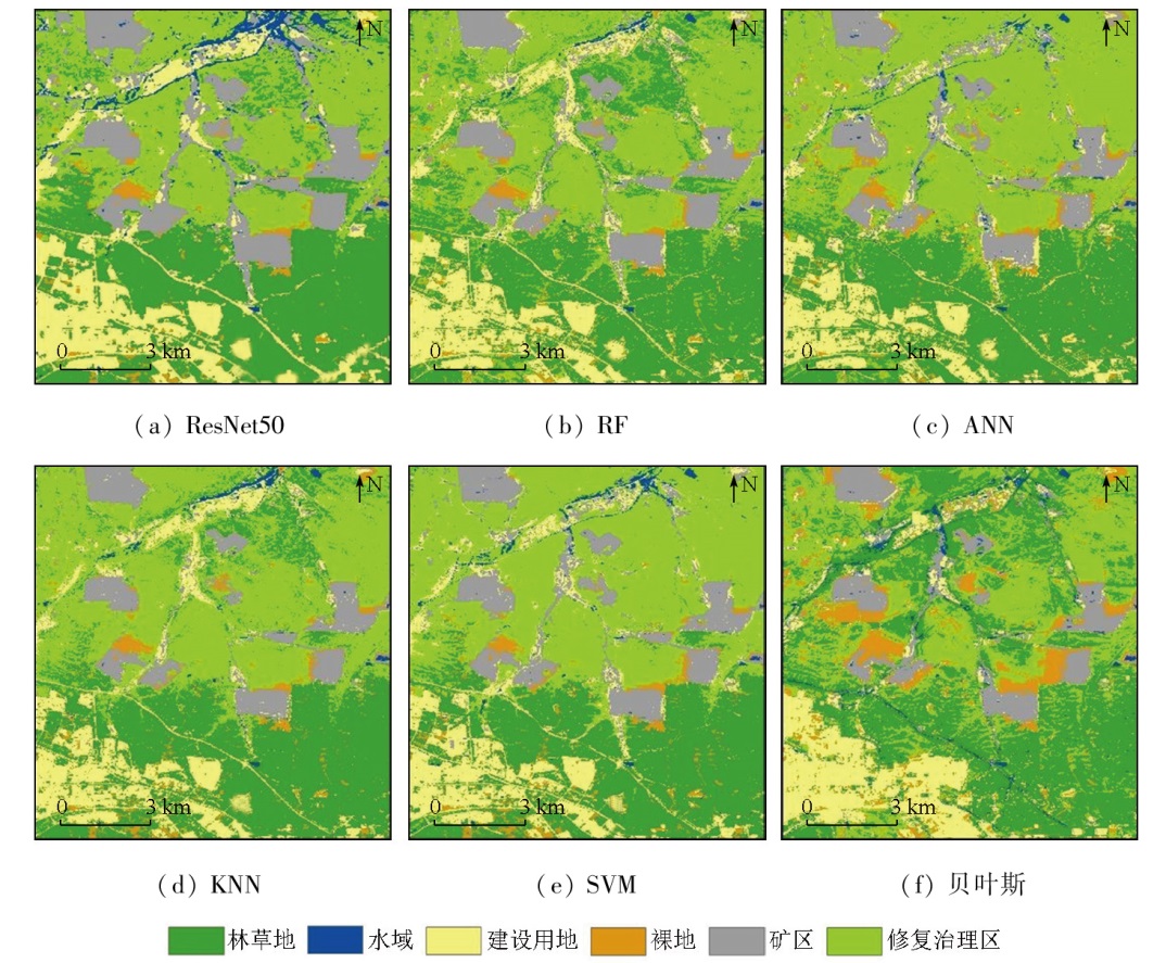
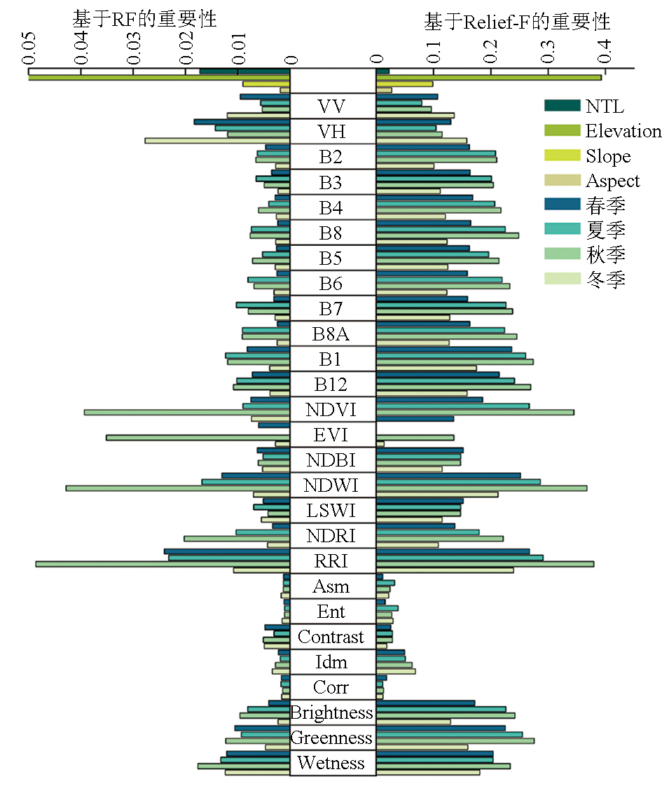
Abstract Resource development in mining areas alters land use patterns and causes ecological damage. This renders land use identification crucial to ecological restoration and management in mining areas. Although remote sensing imagery is widely used for land use classification, the use of a single data source has limitations in the classification for mining areas. Additionally, it is difficult for conventional machine learning algorithms to effectively perform the classification. To improve classification accuracy, this study investigated the eastern part of Dongsheng District, Ordos City as an example to conduct land use classification for mining areas using a convolutional neural network (CNN) combined with multi-source remote sensing data. First, a multi-source remote sensing time series feature set was developed using data from Sentinel-1/2, Luojia-1 01, and the NASA digital elevation model (DEM). Next, optimal features were selected using the Relief-F algorithm combined with a random forest algorithm. Finally, information on surface features was extracted using the ResNet50 CNN model. This facilitated land use classification in the mining area. The results show that the proposed method achieved an overall land use classification accuracy of 95.36% and a Kappa coefficient of 0.942 1, outperforming conventional methods such as the random forest approach. Furthermore, selecting optimal features using Relief-F combined with the random forest approach enhanced the classification accuracy of various classifiers. This study offers a methodological reference for land use classification of mining areas.
|
| Keywords
mining area land use
multi-source remote sensing features
Relief-F
random forest
feature selection
ResNet50
|
|
|
|
Issue Date: 03 September 2025
|
|
|
| [1] |
Qian T N, Bagan H, Kinoshita T, et al. Spatial-temporal analyses of surface coal mining dominated land degradation in Holingol,Inner Mongolia[J]. IEEE Journal of Selected Topics in Applied Earth Observations and Remote Sensing, 2014, 7(5):1675-1687.
|
| [2] |
Sonter L J, Herrera D, Barrett D J, et al. Mining drives extensive deforestation in the Brazilian Amazon[J]. Nature Communications, 2017, 8(1):1013.
doi: 10.1038/s41467-017-00557-w
pmid: 29044104
|
| [3] |
Chen W T, Li X J, Wang L Z. Fine land cover classification in an open pit mining area using optimized support vector machine and WorldView-3 imagery[J]. Remote Sensing, 2019, 12(1):82.
|
| [4] |
张伟, 吴艳民, 刘吉凯. Landsat系列影像支持下的凤阳县石英砂矿区土地利用动态监测[J]. 测绘通报, 2018(6):91-97.
doi: 10.13474/j.cnki.11-2246.2018.0183
|
| [4] |
Zhang W, Wu Y M, Liu J K. Land use dynamic monitoring of Fengyang quartz mine area based on landsat images[J]. Bulletin of Surveying and Mapping, 2018(6):91-97.
doi: 10.13474/j.cnki.11-2246.2018.0183
|
| [5] |
Lavanya K, Gondchar A, Mathew I M, et al. Land cover classification using Landsat7 data for land sustainability[J]. Wireless Personal Communications, 2023, 132(1):679-697.
|
| [6] |
Lobo F D L, Souza-Filho P W M, Novo E M L d M, et al. Mapping mining areas in the Brazilian Amazon using MSI/Sentinel-2 imagery (2017)[J]. Remote Sensing, 2018, 10(8):1178.
|
| [7] |
王德军, 姜琦刚, 李远华, 等. 基于Sentinel-2A/B时序数据与随机森林算法的农耕区土地利用分类[J]. 国土资源遥感, 2020, 32(4):236-243.doi:10.6046/gtzyyg.2020.04.29.
|
| [7] |
Wang D J, Jiang Q G, Li Y H, et al. Land use classification of farming areas based on time series Sentinel-2A/B data and random forest algorithm[J]. Remote Sensing for Land and Resources, 2020, 32(4):236-243.doi:10.6046/gtzyyg.2020.04.29.
|
| [8] |
Yuh Y G, Tracz W, Matthews H D, et al. Application of machine learning approaches for land cover monitoring in northern Cameroon[J]. Ecological Informatics, 2023, 74:101955.
|
| [9] |
Alshari E A, Abdulkareem M B, Gawali B W. Classification of land use/land cover using artificial intelligence (ANN-RF)[J]. Frontiers in Artificial Intelligence, 2023, 5:964279.
|
| [10] |
Park J, Lee Y, Lee J. Assessment of machine learning algorithms for land cover classification using remotely sensed data[J]. Sensors and Materials, 2021, 33(11):3885-3902.
|
| [11] |
Rawat S, Saini R. Evaluating the impact of sampling designs on the performance of machine learning techniques for land use land cover classification using Sentinel-2 data[J]. International Journal of Remote Sensing, 2023, 44(24):7889-7908.
|
| [12] |
Arrechea-Castillo D A, Solano-Correa Y T, Muñoz-Ordóñez J F, et al. Multiclass land use and land cover classification of Andean sub-basins in Colombia with sentinel-2 and deep learning[J]. Remote Sensing, 2023, 15(10):2521.
|
| [13] |
Zhou G D, Xu J H, Chen W T, et al. Deep feature enhancement method for land cover with irregular and sparse spatial distribution features:A case study on open-pit mining[J]. IEEE Transactions on Geoscience and Remote Sensing, 2023, 61:1-20.
|
| [14] |
胡云锋, 商令杰, 张千力, 等. 基于GEE平台的1990年以来北京市土地变化格局及驱动机制分析[J]. 遥感技术与应用, 2018, 33(4):573-583.
doi: 10.11873/j.issn.1004-0323.2018.4.0573
|
| [14] |
Hu Y F, Shang L J, Zhang Q L, et al. Land change patterns and driving mechanism in Beijing since 1990 based on GEE platform[J]. Remote Sensing Technology and Application, 2018, 33(4):573-583.
|
| [15] |
Zeng H W, Wu B F, Wang S, et al. A synthesizing land-cover classification method based on Google Earth Engine:A case study in nzhelele and levhuvu catchments,South Africa[J]. Chinese Geographical Science, 2020, 30(3):397-409.
|
| [16] |
毛丽君, 李明诗. GEE环境下联合Sentinel主被动遥感数据的国家公园土地覆盖分类[J]. 武汉大学学报(信息科学版), 2023, 48(5):756-764.
|
| [16] |
Mao L J, Li M S. Integrating sentinel active and passive remote sensing data to land cover classification in a National Park from GEE platform[J]. Geomatics and Information Science of Wuhan University, 2023, 48(5):756-764.
|
| [17] |
陈彦四, 黄春林, 侯金亮, 等. 基于多时相Sentinel-2影像的黑河中游玉米种植面积提取研究[J]. 遥感技术与应用, 2021, 36(2):324-331.
doi: 10.11873/j.issn.1004-0323.2021.2.0324
|
| [17] |
Chen Y S, Huang C L, Hou J L, et al. Extraction of maize planting area based on multi-temporal sentinel-2 imagery in the middle reaches of Heihe River[J]. Remote Sensing Technology and Application, 2021, 36(2):324-331.
|
| [18] |
Huete A, Didan K, Miura T, et al. Overview of the radiometric and biophysical performance of the MODIS vegetation indices[J]. Remote Sensing of Environment, 2002, 83(1/2):195-213.
|
| [19] |
Xu H Q. Modification of normalised difference water index (NDWI) to enhance open water features in remotely sensed imagery[J]. International Journal of Remote Sensing, 2006, 27(14):3025-3033.
|
| [20] |
Xiao X M, Hollinger D, Aber J, et al. Satellite-based modeling of gross primary production in an evergreen needleleaf forest[J]. Remote Sensing of Environment, 2004, 89(4):519-534.
|
| [21] |
Zha Y, Gao J, Ni S. Use of normalized difference built-up index in automatically mapping urban areas from TM imagery[J]. International Journal of Remote Sensing, 2003, 24(3):583-594.
|
| [22] |
吴宏安, 蒋建军, 张海龙, 等. 比值居民地指数在城镇信息提取中的应用[J]. 南京师大学报(自然科学版), 2006, 29(3):118-121.
|
| [22] |
Wu H A, Jiang J J, Zhang H L, et al. Application of ratio resident-area index to retrieve urban residential areas based on landsat TM data[J]. Journal of Nanjing Normal University (Natural Science), 2006, 29(3):118-121.
|
| [23] |
张晓伦, 甘淑. 基于NDRI像元二分模型的石漠化信息提取研究[J]. 新技术新工艺, 2014(1):72-75.
|
| [23] |
Zhang X L, Gan S. Research on extracting rocky desertification information based on NDRI dimidiate pixel model[J]. New Technology and New Process, 2014(1):72-75.
|
| [24] |
霍轩琳, 牛振国, 张波, 等. 高寒湿地分类的遥感特征优选研究[J]. 遥感学报, 2023, 27(4):1045-1060.
|
| [24] |
Huo X L, Niu Z G, Zhang B, et al. Remote sensing feature selection for alpine wetland classification[J]. National Remote Sensing Bulletin, 2023, 27(4):1045-1060.
|
| [25] |
刘吉超, 王锋. 基于Relief-F的半监督特征选择算法[J]. 郑州大学学报(理学版), 2021, 53(1):42-46,53.
|
| [25] |
Liu J C, Wang F. A semi-supervised feature selection algorithm based on relief-F[J]. Journal of Zhengzhou University (Natural Science Edition), 2021, 53(1):42-46,53.
|
| [26] |
Liao Q T. Intelligent classification model of land resource use using deep learning in remote sensing images[J]. Ecological Modelling, 2023, 475:110231.
|
| [27] |
He K M, Zhang X Y, Ren S Q, et al. Deep residual learning for image recognition[C]// 2016 IEEE Conference on Computer Vision and Pattern Recognition (CVPR).June 27-30,2016,Las Vegas,NV,USA.IEEE, 2016:770-778.
|
| [28] |
张立亭, 夏文生, 罗亦泳, 等. 改进双重注意力机制结合ResNet50的遥感图像分类[J]. 测绘科学, 2023, 48(4):98-105.
|
| [28] |
Zhang L T, Xia W S, Luo Y Y, et al. Improved double attention mechanism combined with ResNet50 for remote sensing image classification[J]. Science of Surveying and Mapping, 2023, 48(4):98-105.
|
| [29] |
Dastour H, Hassan Q K. A comparison of deep transfer learning methods for land use and land cover classification[J]. Sustainability, 2023, 15(10):7854.
|
| [30] |
Sawant S, Ghosh J K. Land use land cover classification using Sentinel imagery based on deep learning models[J]. Journal of Earth System Science, 2024, 133(2):101.
|
|
Viewed |
|
|
|
Full text
|
|
|
|
|
Abstract
|
|
|
|
|
Cited |
|
|
|
|
| |
Shared |
|
|
|
|
| |
Discussed |
|
|
|
|
 2025,
Vol. 37
2025,
Vol. 37