|
|
|

|
|
|
Remote sensing identification of industrial solid waste and open pits in mining areas based on the multiscale sample set optimization strategy |
ZOU Haijing1,2( ), ZOU Bin1,2(), WANG Yulong1,2, ZHANG Bo1,2, ZOU Lunwen3 ), ZOU Bin1,2(), WANG Yulong1,2, ZHANG Bo1,2, ZOU Lunwen3 |
1. School of Geosciences and Info-physics, Central South University, Changsha 410083, China
2. Key Laboratory of Spatio-temporal Information and Intelligent Services, Ministry of Natural Resources of China, Changsha 410083, China
3. College of Geographical Sciences, Hunan Normal University, Changsha 410081, China |
|
|
|
|
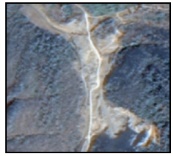
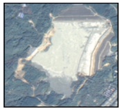
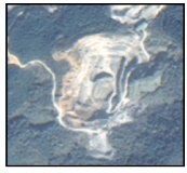
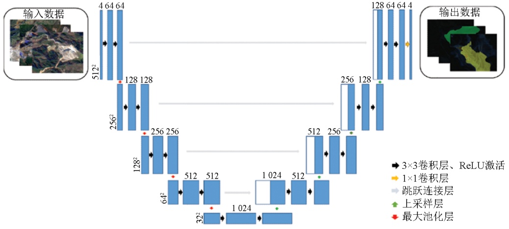
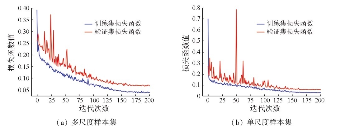
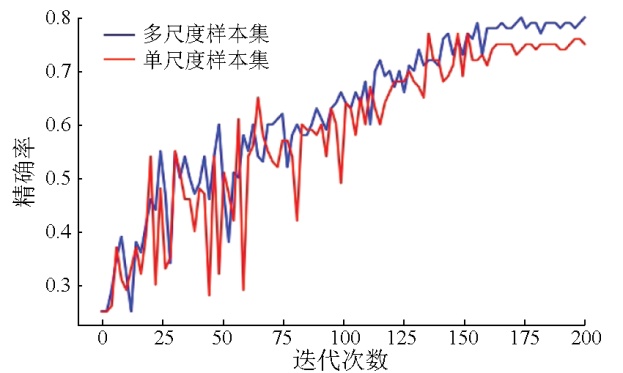
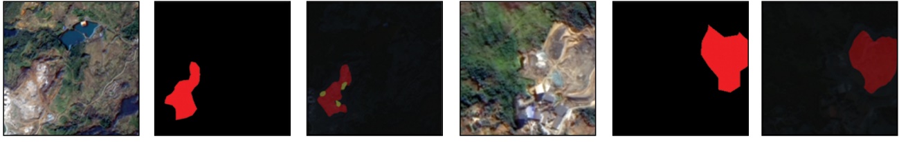
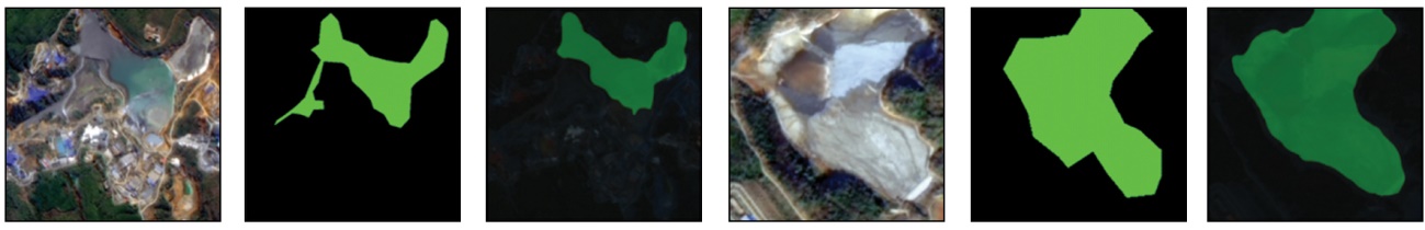
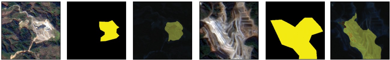
Abstract A timely and accurate understanding of the spatial extents and distributions of industrial solid waste and open pits in mining areas is significant for the precise control of solid waste contamination and the ecosystem conservation. Remote sensing technology is an effective monitoring method. However, single-scale sample sets fail to fully represent the features of industrial solid waste yards and open pits with different shapes and sizes. Constructing multiscale sample sets may be effective in solving the problem of incomplete feature representation for different industrial solid waste yards and open pits, thereby enhancing the identification accuracy and generalization capability of models. By fully considering the differences in the shape and size of different industrial solid waste yards and open pits, this study proposed a remote sensing identification method for industrial solid waste and open pits based on the multiscale sample set optimization strategy. In the proposed method, a multiscale sample set was prepared based on the preprocessed data of the GF-1B, GF-1C, and GF6 satellite remote sensing images. Subsequently, a U-Net deep learning network model was constructed to identify industrial solid waste and open pits. Finally, the identification accuracy was compared with that of the single-scale sample set model. The results show that the U-Net deep learning network model based on the multiscale sample set achieved identification accuracy of 81.23 %, recall of 66.88 %, F1-score of 73.36 %, and average intersection over union of 73.55 %, suggesting improvements by 6.02, 1.02, 3.12, and 9.86 percentage points, respectively, compared to the single-scale sample set model. Overall, this study provides a reliable approach for precisely monitoring industrial solid waste and open pits.
|
| Keywords
multiscale
deep learning
industrial solid waste
remote sensing identification
|
|
|
|
Issue Date: 01 July 2025
|
|
|
| [1] |
孙坚, 耿春雷, 张作泰, 等. 工业固体废弃物资源综合利用技术现状[J]. 材料导报, 2012, 26(11):105-109.
|
| [1] |
Sun J, Geng C L, Zhang Z T, et al. Present situation of comprehensive utilization technology of industrial solid waste[J]. Materials Reports, 2012, 26(11):105-109.
|
| [2] |
Gao S, Chen Y, Li K, et al. Mapping opencast iron mine and mine solid waste based on a new spectral index from medium spatial re-solution satellite data[J]. IEEE Journal of Selected Topics in Applied Earth Observations and Remote Sensing, 2021,14:7788-7798.
|
| [3] |
Chen W, Peng L, Hu K, et al. Spectroscopic response of soil organic matter in mining area to Pb/Cd heavy metal interaction:A mirror of coherent structural variation[J]. Journal of Hazardous Materials, 2020,393:122425.
|
| [4] |
刘雪龙. 面向对象的遥感影像工业固体废物信息提取方法研究[D]. 北京: 中国地质大学(北京), 2013.
|
| [4] |
Liu X L. Object-oriented remote sensing images industrial solid waste information extraction method research[D]. Beijing: China University of Geosciences(Beijing), 2013.
|
| [5] |
Kwarteng A Y, Al-Enezi A. Assessment of Kuwait’s Al-Qurain landfill using remote sensing imagery[J]. Journal of Environmental Science and Health Part A:Toxic/Hazardous Substances and Environmental Engineering, 2004, 39(2):351-364.
|
| [6] |
Bai T, Sun K, Deng S, et al. Multi-scale hierarchical sampling change detection using Random Forest for high-resolution satellite imagery[J]. International Journal of Remote Sensing, 2018, 39(21):7523-7546.
|
| [7] |
Rodriguez-Galiano V F, Ghimire B, Rogan J, et al. An assessment of the effectiveness of a random forest classifier for land-cover classification[J]. ISPRS Journal of Photogrammetry and Remote Sen-sing, 2012,67:93-104.
|
| [8] |
Li P, Xu H, Guo J. Urban building damage detection from very high resolution imagery using OCSVM and spatial features[J]. International Journal of Remote Sensing, 2010, 31(13):3393-3409.
|
| [9] |
Ye S, Chen D, Yu J. A targeted change-detection procedure by combining change vector analysis and post-classification approach[J]. ISPRS Journal of Photogrammetry and Remote Sensing, 2016,114:115-124.
|
| [10] |
Silvestri S, Omri M. A method for the remote sensing identification of uncontrolled landfills:Formulation and validation[J]. International Journal of Remote Sensing, 2008, 29(4):975-989.
|
| [11] |
吴倩雯, 况润元, 张刚华, 等. 东江源稀土矿区土地利用变化遥感监测研究[J]. 测绘科学, 2019, 44(3):51-56.
|
| [11] |
Wu Q W, Kuang R Y, Zhang G H, et al. Remote sensing monitoring of land-use change in rare earth mining area in the source region of Dongjiang River[J]. Science of Surveying and Mapping, 2019, 44(3):51-56.
|
| [12] |
卢遥, 卢小平, 武永斌, 等. 综合机载LiDAR与高分影像的煤矿区典型地物提取方法[J]. 测绘通报, 2015(12):57-59.
doi: 10.13474/j.cnki.11-2246.2015.378
|
| [12] |
Lu Y, Lu X P, Wu Y B, et al. Typical surface features extraction in mining area based on data of LiDAR and WorldView-2[J]. Bulletin of Surveying and Mapping, 2015(12):57-59.
doi: 10.13474/j.cnki.11-2246.2015.378
|
| [13] |
Liu T, Zheng P, Bao J. Deep learning-based welding image recognition:A comprehensive review[J]. Journal of Manufacturing Systems, 2023,68:601-625.
|
| [14] |
李庆, 陈俊杰, 李庆亭, 等. 基于SSD模型的京津冀地区尾矿库检测[J]. 遥感技术与应用, 2021, 36(2):293-303.
doi: 10.11873/j.issn.1004-0323.2021.2.0293
|
| [14] |
Li Q, Chen J J, Li Q T, et al. Detection of tailings pond in Beijing-Tianjin-Hebei Region based on SSD model[J]. Remote Sensing Technology and Application, 2021, 36(2):293-303.
|
| [15] |
闫凯, 沈汀, 陈正超, 等. 基于深度学习的SSD模型尾矿库自动提取[J]. 中国科学院大学学报, 2020, 37(3):360-367.
doi: 10.7523/j.issn.2095-6134.2020.03.009
|
| [15] |
Yan K, Shen T, Chen Z C, et al. Automatic extraction of tailing pond based on SSD of deep learning[J]. Journal of University of Chinese Academy of Sciences, 2020, 37(3):360-367.
doi: 10.7523/j.issn.2095-6134.2020.03.009
|
| [16] |
刘冰洁, 邢旭东, 吴浩, 等. 深度学习支持下的尾矿库遥感识别方法[J]. 测绘科学, 2021, 46(12):129-139.
|
| [16] |
Liu B J, Xing X D, Wu H, et al. Remote sensing identification of tailings pond based on deep learning model[J]. Science of Surveying and Mapping, 2021, 46(12):129-139.
|
| [17] |
张峰极. 多源遥感影像露天开采区深度学习提取方法研究[D]. 合肥: 安徽大学, 2019.
|
| [17] |
Zhang F J. Research on deep learning extraction method in open mining area based on multi-source remote sensing images[D]. Hefei: Anhui University, 2019.
|
| [18] |
张蜀军. 基于实例分割的高分遥感无序固废堆场识别[D]. 成都: 西南交通大学, 2021.
|
| [18] |
Zhang S J. Disorderd solid waste yards recognition from high-resolution remote sensing images based on instance segmentation[D]. Chengdu: SouthwestJiaotong University, 2021.
|
| [19] |
张仙, 李伟, 陈理, 等. 露天开采矿区要素遥感提取研究进展及展望[J]. 自然资源遥感, 2023, 35(2):25-33.doi: 10.6046/zrzyyg.2022141.
|
| [19] |
Zhang X, Li W, Chen L, et al. Research progress and prospect of remote sensing-based feature extraction of opencast mining areas[J]. Remote Sensing for Natural Resources, 2023, 35(2):25-33.doi: 10.6046/zrzyyg.2022141.
|
| [20] |
张成业, 邢江河, 李军, 等. 基于U-Net网络和GF-6影像的尾矿库空间范围识别[J]. 自然资源遥感, 2021, 33(4):252-257.doi:10.6046/zrzyyg.2021017.
|
| [20] |
Zhang C Y, Xing J H, Li J, et al. Recognition of the spatial scopes of tailing ponds based on U-Net and GF-6 images[J]. Remote Sensing for Natural Resources, 2021, 33(4):252-257.doi:10.6046/zrzyyg.2021017.
|
| [21] |
王浩. 融入图卷积全局推理的固废堆场高分遥感检测及其环境影响力评估[D]. 成都: 西南交通大学, 2021.
|
| [21] |
Wang H. High-resolution remote sensing detection of solid waste yard integrated with graph convolution global reasoning and its environmental impact assessment[D]. Chengdu: SouthwestJiaotong University, 2021.
|
| [22] |
段彦玮, 文倩, 孙水娟, 等. 矿产资源型城市的生态承载力与可持续发展研究——以湖南省郴州市为例[J]. 湖南农机, 2011, 38(3):110-112.
|
| [22] |
Duan Y W, Wen Q, Sun S J, et al. Research on ecological carrying capacity and sustainable development:In a mining city a case study in Chenzhou City[J]. Hunan Agricultural Machinery, 2011, 38(3):110-112.
|
| [23] |
李威, 邓武军, 邓家琪, 等. 郴州创建国家可持续发展议程创新示范区的实施路径与思考[J]. 中国工程咨询, 2023(8):46-50.
|
| [23] |
Li W, Deng W J, Deng J Q, et al. Implementation path and thinking of creating national sustainable development agenda innovation demonstration zone in Chenzhou[J]. China Engineering Consultants, 2023(8):46-50.
|
| [24] |
胡杰, 张莹, 谢仕义. 国产遥感影像分类技术应用研究进展综述[J]. 计算机工程与应用, 2021, 57(3):1-13.
doi: 10.3778/j.issn.1002-8331.2007-0101
|
| [24] |
Hu J, Zhang Y, Xie S Y. Summary of research progress on application of domestic remote sensing image classification technology[J]. Computer Engineering and Applications, 2021, 57(3):1-13.
doi: 10.3778/j.issn.1002-8331.2007-0101
|
| [25] |
何直蒙, 丁海勇, 安炳琪. 高分辨率遥感影像建筑物提取的空洞卷积E-Unet算法[J]. 测绘学报, 2022, 51(3):457-467.
doi: 10.11947/j.AGCS.2022.20200601
|
| [25] |
He Z M, Ding H Y, An B Q. E-Unet:Aatrous convolution-based neural network for building extraction from high-resolution remote sensing images[J]. ActaGeodaetica et Cartographica Sinica, 2022, 51(3):457-467.
|
| [26] |
Chen D Y, Peng L, Li W C, et al. Building extraction and number statistics in WUI areas based on UNet structure and ensemble learning[J]. Remote Sensing, 2021, 13(6):1172.
|
| [27] |
Chen L C, Zhu Y, Papandreou G, et al. Encoder-decoder with atrous separable convolution for semantic image segmentation[C]// European Conference on Computer Vision.Springer, 2018:833-851.
|
| [28] |
Strudel R, Garcia R, Laptev I, et al. Segmenter:Transformer for semantic segmentation[C]// 2021 IEEE/CVF International Conference on Computer Vision (ICCV).IEEE, 2021:7242-7252.
|
| [29] |
许玥, 冯梦如, 皮家甜, 等. 基于深度学习模型的遥感图像分割方法[J]. 计算机应用, 2019, 39(10):2905-2914.
doi: 10.11772/j.issn.1001-9081.2019030529
|
| [29] |
Xu Y, Feng M R, Pi J T, et al. Remote sensing image segmentation method based on deep learning model[J]. Journal of Computer Applications, 2019, 39(10):2905-2914.
doi: 10.11772/j.issn.1001-9081.2019030529
|
|
Viewed |
|
|
|
Full text
|
|
|
|
|
Abstract
|
|
|
|
|
Cited |
|
|
|
|
| |
Shared |
|
|
|
|
| |
Discussed |
|
|
|
|
 2025,
Vol. 37
2025,
Vol. 37