Please wait a minute...
 
国土资源遥感  2018, Vol. 30 Issue (4): 212-217    DOI: 10.6046/gtzyyg.2018.04.32
     本期目录 | 过刊浏览 | 高级检索 |
矿山遥感监测解译记录表自动生成方法研究与实现
刁明光1, 刘芳1, 谭专条1, 薛涛1, 王彦佐2
1. 中国地质大学(北京) 信息工程学院,北京 100083
2. 中国国土资源航空物探遥感中心,北京 100083
Research and implement on automatic production method of mine remote sensing monitoring interpretation record table
Mingguang DIAO1, Fang LIU1, Zhuantiao TAN1, Tao XUE1, Yanzuo WANG2
1. School of Information Engineering, China University of Geosciences(Beijing), Beijing 100083, China
2. China Aero Geophysical Survey and Remote Sensing Center for Land and Resources, Beijing 100083, China
全文: PDF(3569 KB)   HTML  
输出: BibTeX | EndNote (RIS)      
摘要 

矿山遥感监测过程中,技术人员会利用ArcMap软件提取矿山开采区遥感监测成果数据中的相关信息制作解译记录表,以实现对矿山开采状况的遥感监测。手工制作解译记录表存在制作成本高、专业性强、工作量大、制表格式不一致、数据准确性低等问题。本研究提出基于AE(ArcGIS Engine)进行插件式设计的矿山解译记录表自动生成方法,自动提取矿山开采区域遥感监测成果数据的属性信息和空间信息,结合文档对象模型(document object model,DOM)自动编辑文档,完成解译记录表的自动生成工作。

服务
把本文推荐给朋友
加入引用管理器
E-mail Alert
RSS
作者相关文章
刁明光
刘芳
谭专条
薛涛
王彦佐
关键词 AE矿山监测文档对象模型解译记录表遥感影像    
Abstract

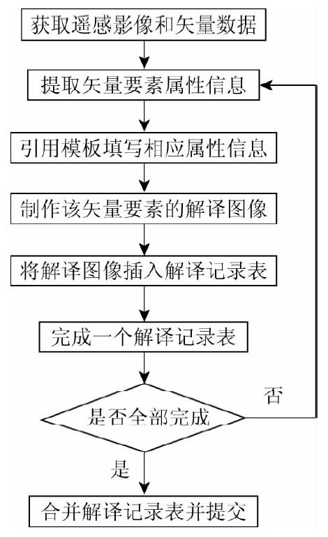
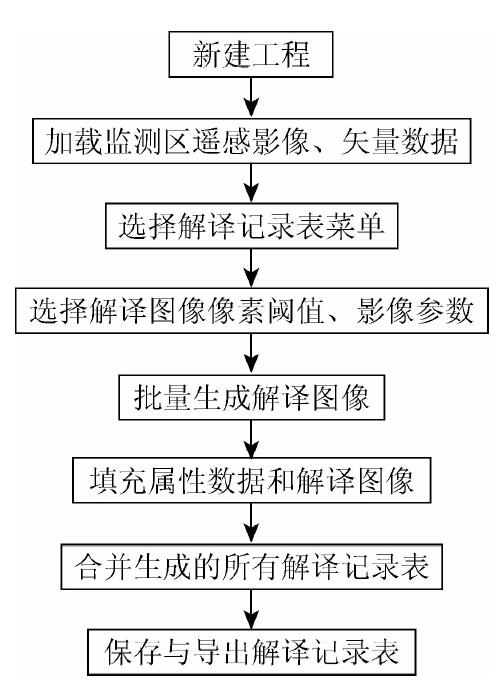
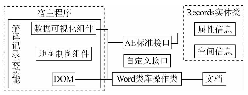
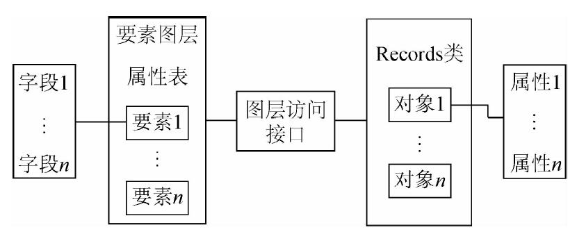
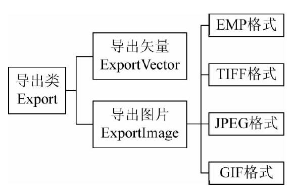
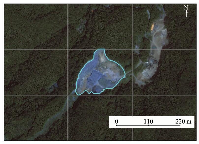
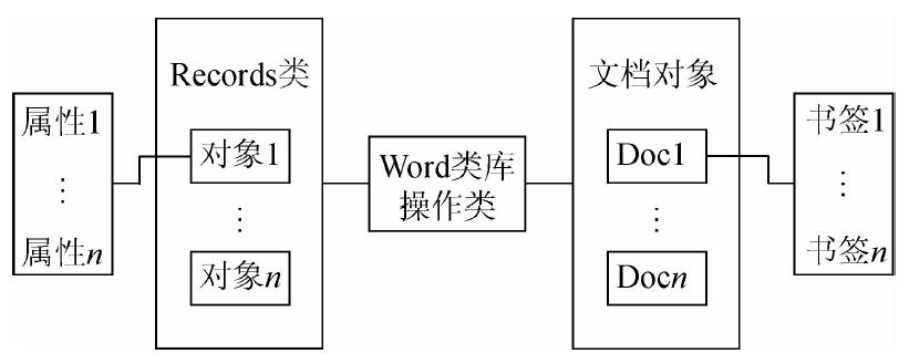
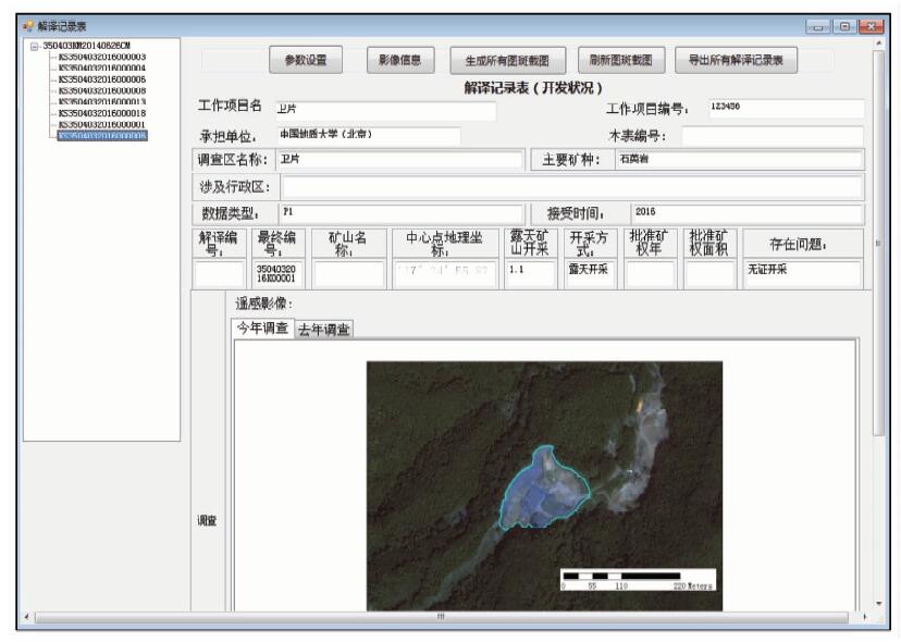
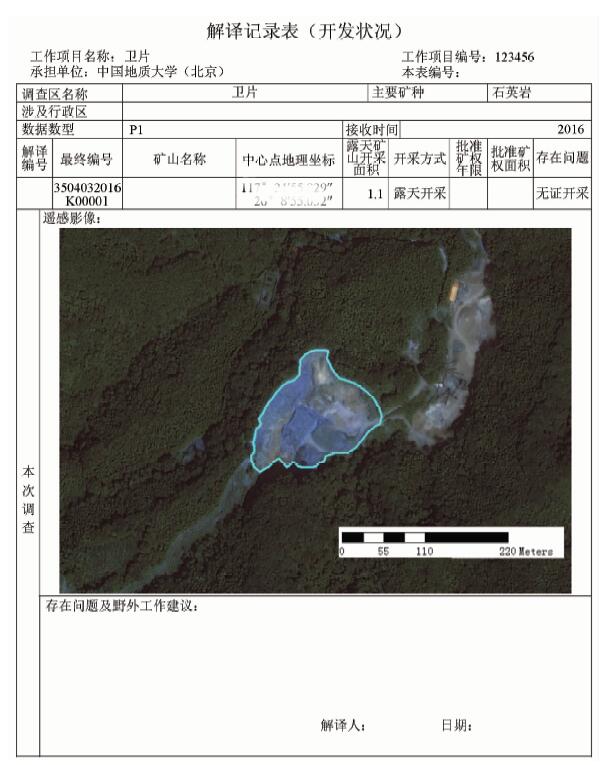
In the process of mine remote sensing monitoring, technicians need to use ArcMap to extract valuable information from geographic data and make the interpretation record table aimed at monitoring mineral exploitation. Manual interpretation record table has many problems, such as high cost, more professional skill requirements, heavy work load, format inconsistency and low accuracy of data. The method of automatically produced mine interpretation record table can automatically extract spatial and attribute information from geographic data based on ArcGIS Engine(AE) plug-in, then Word documents are edited based on document object model(DOM),and finally the production of interpretation record table is realized automatically.

Key wordsAE    mine monitoring    document object model    interpretation record table    remote sensing image
收稿日期: 2017-04-24      出版日期: 2018-12-07
:  TP319  
基金资助:中国地质调查局项目“矿山遥感监测多维数据平台建设与应用”资助(1212011220083)
作者简介: 刁明光(1970-),男,副教授,主要从事地学信息工程和软件工程学研究。Email: dmg@cugb.edu.cn
引用本文:   
刁明光, 刘芳, 谭专条, 薛涛, 王彦佐. 矿山遥感监测解译记录表自动生成方法研究与实现[J]. 国土资源遥感, 2018, 30(4): 212-217.
Mingguang DIAO, Fang LIU, Zhuantiao TAN, Tao XUE, Yanzuo WANG. Research and implement on automatic production method of mine remote sensing monitoring interpretation record table. Remote Sensing for Land & Resources, 2018, 30(4): 212-217.
链接本文:  
https://www.gtzyyg.com/CN/10.6046/gtzyyg.2018.04.32      或      https://www.gtzyyg.com/CN/Y2018/V30/I4/212
Fig.1  手工解译记录表编制流程
Fig.2  自动解译记录表编制流程
Fig.3  解译记录表的自动生成方法框架
Fig.4  图层-对象数据映射
类名 类描述 属性
MapSurround 地图环境,父类 地图视图Map等
MapTitle 地图名,子类
Legend 图例,子类 样式Format、图标Icon和名称Name等
ScaleBar 比例尺,子类 分隔数Division、颜色BarColor和单位Units等
MarkerNorthArrow 指北针,子类 角度Angle、颜色Color和大小Size等
ScaleText 数字比例,子类 文本Text、单位MapUnits和样式Style等
Tab.1  地图环境类
Fig.5  可导出的图片格式
Fig.6  九宫格定位法示意图
Fig.7  对象-文档映射
Fig.8  解译记录表功能界面
Fig.9  自动生成的解译记录表
[1] 刁明光, 薛涛, 李建存 , 等. 基于ArcGIS的矿山遥感监测成果编制系统[J]. 国土资源遥感, 2016,28(3):194-199.doi: 10.6046/gtzyyg.2016.03.30.
Diao M G, Xue T, Li J C , et al. Production data compilation system of mine remote sensing monitoring based on ArcGIS[J]. Remote Sensing for Land and Resources, 2016,28(3):194-199.doi: 10.6046/gtzyyg.2016.03.30.
[2] 朱敏, 刘刚, 马海涛 , 等. 遥感影像目视解译矢量化分析[J]. 测绘与空间地理信息, 2010,33(4):67-69.
doi: 10.3969/j.issn.1672-5867.2010.04.020
Zhu M, Liu G, Ma H T , et al. Visual interpretation vector analysis of remote sensing image[J]. Geomatics and Spatial Information Technology, 2010,33(4):67-69.
[3] 中国国土资源航空物探遥感中心.全国矿产资源开发环境遥感监测入库数据技术要求( 2017)[Z]. 2017-9.
China Aero Geophysical Survey and Remote Sensing Center for Land and Resources. Production for Data Requirements for Database of Mine Remote Sensing Monitoring( 2017)[Z]. 2017-9.
[4] 施建辉 . 基于ArcGIS Engine的插件式应用系统的实现[J]. 测绘标准化, 2011,27(4):12-15.
Shi J H . The implementation of plugin application system based on ArcGIS Engine[J]. Standardization of Surveying and Mapping, 2011,27(4):12-15.
[5] 张扬, 李小娟, 陈莹 , 等. 基于ArcGIS Engine的专题制图模块的设计与实现——以北京市城市规划信息系统为例[J]. 首都师范大学学报(自然科学版), 2008,29(2):95-100.
doi: 10.3969/j.issn.1004-9398.2008.02.019
Zhang Y, Li X J, Chen Y , et al. Design and realization of the thematic mapping module based on ArcGIS Engine:Take Beijing urban planning information system as example[J]. Journal of Capital Normal University(Natural Sciences Edition), 2008,29(2):95-100.
[6] 张康聪 . 地理信息系统导论(第7版)[M]. 北京: 电子工业出版社, 2014: 232-241.
Zhang K C. Introduction to Geographic Information Systems(Seventh Edition)[M]. Beijing: Electronic Industry Press, 2014: 232-241.
[7] 微软 . Word对象模型概述[EB/OL].[2017-3-13].https://msdn.microsoft.com/zh-cn/library/kw65a0we.aspx.
Microsoft.Word object model overview[EB/OL].[2017-3-13].https://msdn.microsoft.com/zh-cn/library/kw65a0we.aspx.
[1] 薛白, 王懿哲, 刘书含, 岳明宇, 王艺颖, 赵世湖. 基于孪生注意力网络的高分辨率遥感影像变化检测[J]. 自然资源遥感, 2022, 34(1): 61-66.
[2] 宋仁波, 朱瑜馨, 郭仁杰, 赵鹏飞, 赵珂馨, 朱洁, 陈颖. 基于多源数据集成的城市建筑物三维建模方法[J]. 自然资源遥感, 2022, 34(1): 93-105.
[3] 王译著, 黄亮, 陈朋弟, 李文国, 余晓娜. 联合显著性和多方法差异影像融合的遥感影像变化检测[J]. 自然资源遥感, 2021, 33(3): 89-96.
[4] 桑潇, 张成业, 李军, 朱守杰, 邢江河, 王金阳, 王兴娟, 李佳瑶, 杨颖. 煤炭开采背景下的伊金霍洛旗土地利用变化强度分析[J]. 自然资源遥感, 2021, 33(3): 148-155.
[5] 卢麒, 秦军, 姚雪东, 吴艳兰, 朱皓辰. 基于多层次感知网络的GF-2遥感影像建筑物提取[J]. 国土资源遥感, 2021, 33(2): 75-84.
[6] 胡苏李扬, 李辉, 顾延生, 黄咸雨, 张志麒, 汪迎春. 基于高分辨率遥感影像的神农架大九湖湿地土地利用类型变化及其驱动力分析——来自长时间尺度多源遥感信息的约束[J]. 国土资源遥感, 2021, 33(1): 221-230.
[7] 刘钊, 赵桐, 廖斐凡, 李帅, 李海洋. 基于语义分割网络的高分遥感影像城市建成区提取方法研究与对比分析[J]. 国土资源遥感, 2021, 33(1): 45-53.
[8] 孙珂. 融合超像元与峰值密度特征的遥感影像分类[J]. 国土资源遥感, 2020, 32(4): 41-45.
[9] 卫虹宇, 赵银娣, 董霁红. 基于改进RetinaNet的冷却塔目标检测[J]. 国土资源遥感, 2020, 32(4): 68-73.
[10] 郑智腾, 范海生, 王洁, 吴艳兰, 王彪, 黄腾杰. 改进型双支网络模型的遥感海水网箱养殖区智能提取方法[J]. 国土资源遥感, 2020, 32(4): 120-129.
[11] 李霄, 刘莹, 姚维岭, 杨金中, 李勇志, 汪洁. 基于ArcPy的违法矿山自动出图方法[J]. 国土资源遥感, 2020, 32(3): 247-251.
[12] 薛白, 付钰莹, 崔成玲, 宋艳茹, 赵世湖. 多重约束条件下的不同遥感影像匹配方法[J]. 国土资源遥感, 2020, 32(3): 49-54.
[13] 吴同, 彭玲, 胡媛. 基于SU-RetinaNet的高分辨率遥感影像非正规垃圾堆检测[J]. 国土资源遥感, 2020, 32(3): 90-97.
[14] 李国庆, 黄菁华, 刘冠, 李洁, 翟博超, 杜盛. 基于Landsat8卫星影像土地利用景观破碎化研究——以陕西省延安麻塔流域为例[J]. 国土资源遥感, 2020, 32(3): 121-128.
[15] 康晋洁, 戚浩平, 杨清华, 陈华. 道路通行障碍物遥感检测与通过性评价[J]. 国土资源遥感, 2020, 32(2): 94-102.
Viewed
Full text


Abstract

Cited

  Shared   
  Discussed   
京ICP备05055290号-2
版权所有 © 2015 《自然资源遥感》编辑部
地址:北京学院路31号中国国土资源航空物探遥感中心 邮编:100083
电话:010-62060291/62060292 E-mail:zrzyyg@163.com
本系统由北京玛格泰克科技发展有限公司设计开发