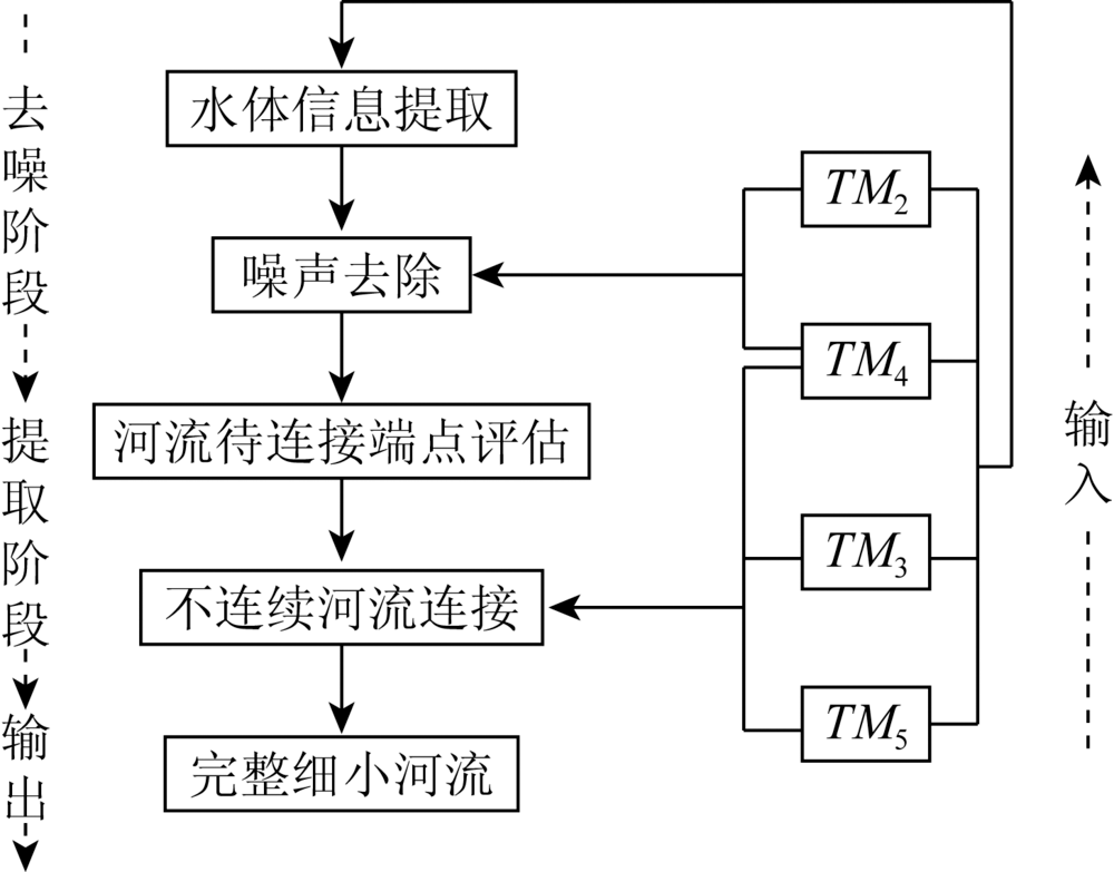
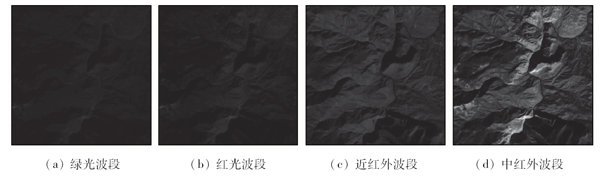
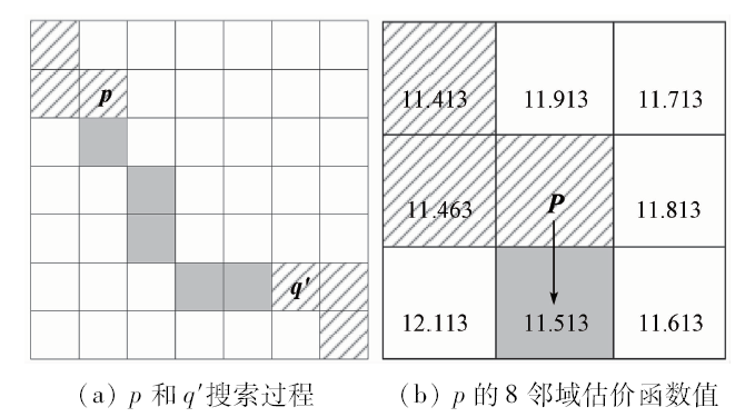
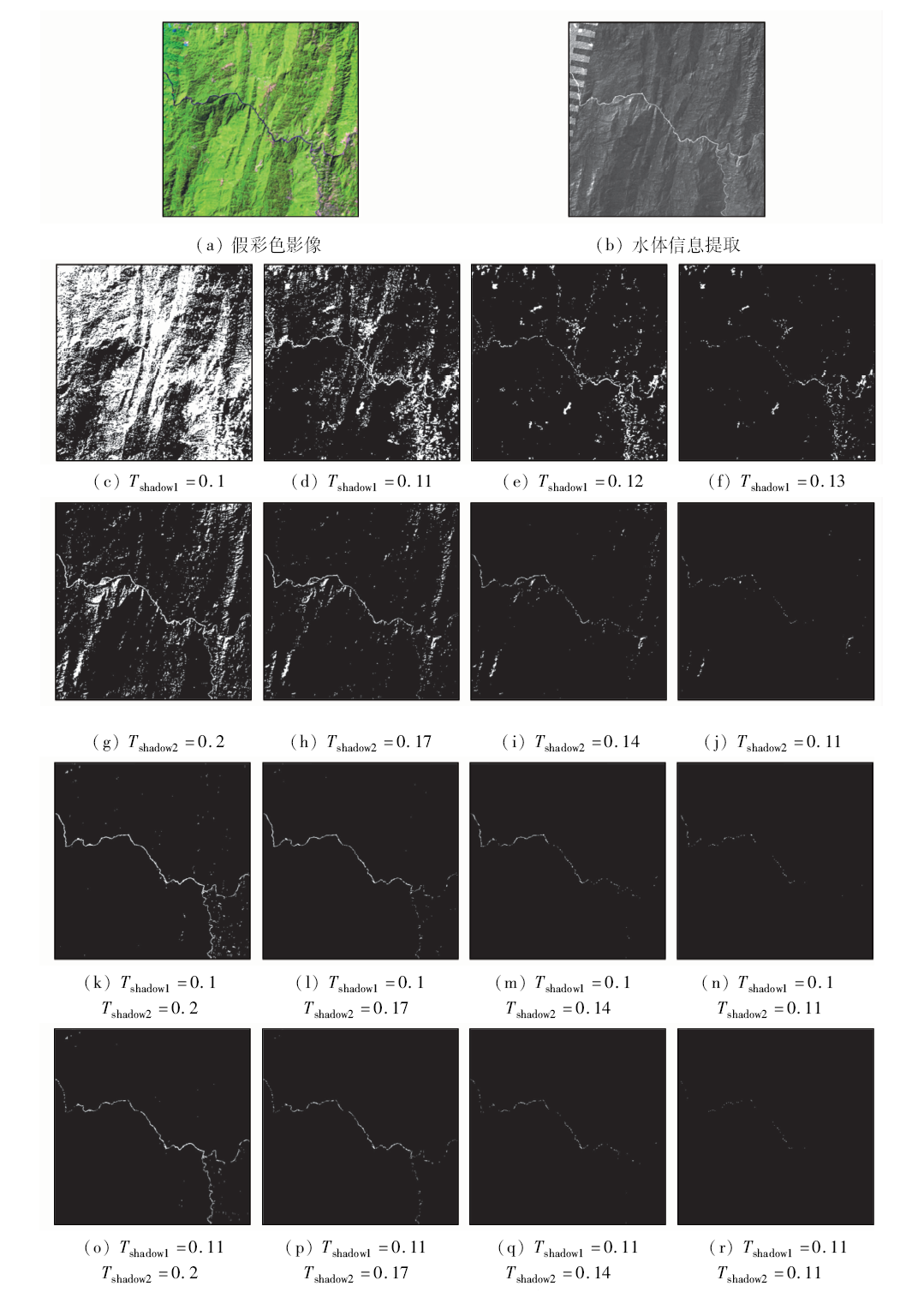
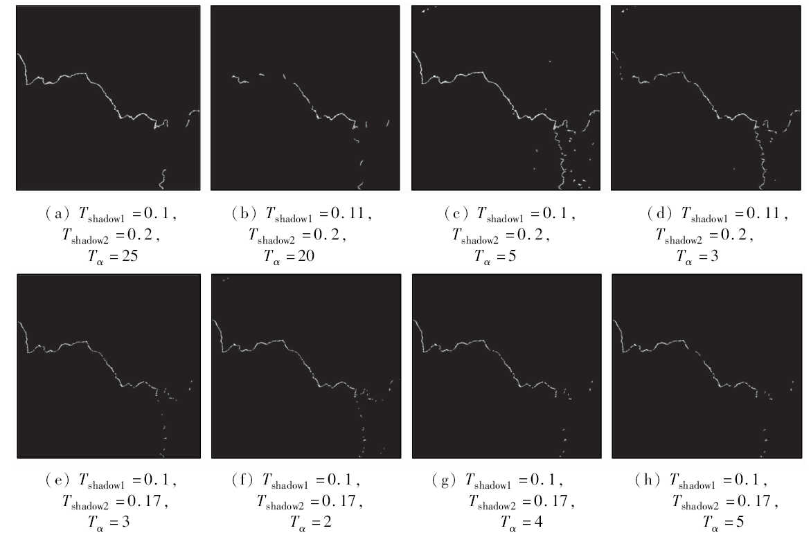
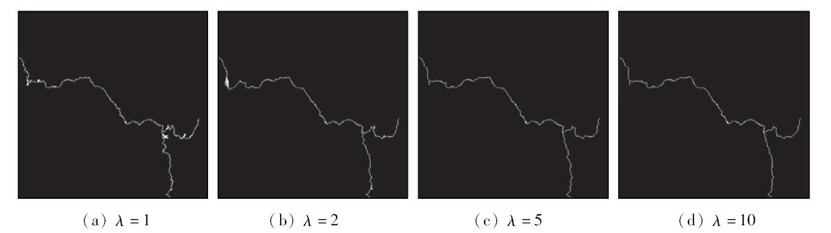
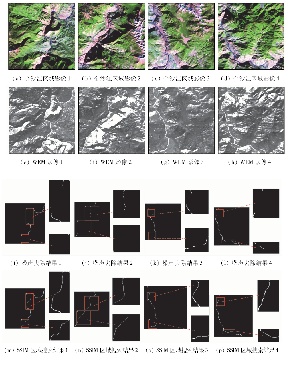
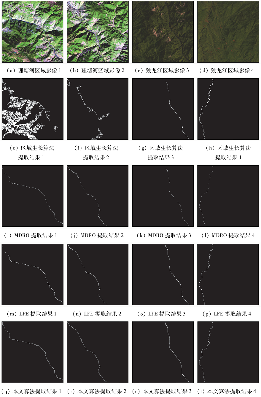
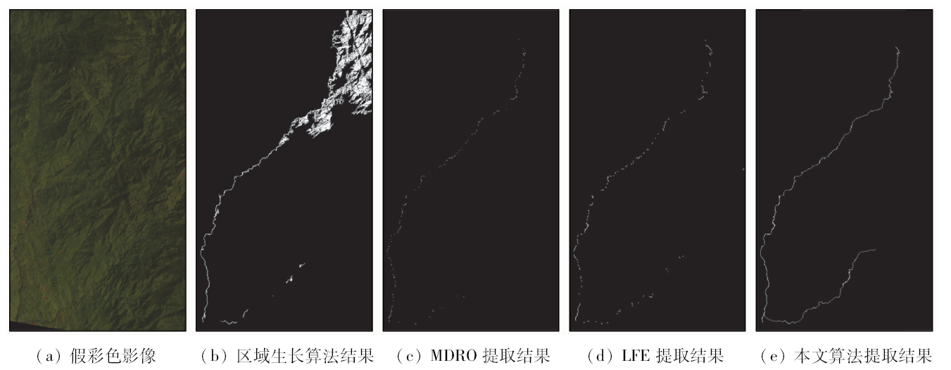
The structural similarity region search algorithm is used to realize the automatic extraction of TM image narrow rivers, which is of great value for disaster assessment and soil and water resources management. The discontinuity of narrow river extraction is the main problem which causes the difficulty in accurate obtaining of information about rivers. Many experts have studied various characteristic properties of water bodies to avoid the phenomenon of river information leakage during extraction. However, due to the complex flow of narrow rivers and the vulnerability to environmental disturbances, it is difficult to achieve complete extraction of river information. Combining structural similarity and heuristic search algorithm, this paper proposes a new method for accurately connecting faulted rivers. The specific process of the method is as follows: Firstly, according to the reflection characteristics of the ground objects, the water body extraction model is used to distinguish the narrow rivers from the irrelevant information. Then, the difference between the gray values of the water bodies on different bands is used to set different thresholds for unrelated noise removal. Third, the discontinuous rivers are evaluated by searching. The area is used to determine the breakpoints to be connected to the river. Finally, the heuristic automatic search connection is realized by using the structural similarity between the 5, 4, and 3 bands of river pixels in the TM image. A comparison with several algorithms shows that the proposed method can solve the problem of river extraction fracture of traditional algorithms and realize the precise connection of discontinuous narrow rivers.
Zhuang Y, Chen C. A method for water body extraction based on the tasselled cap transformation from remote sensing images [C]//2018 Fifth International Workshop on Earth Observation and Remote Sensing Applications(EORSA),Xi’an, 2018: 1-5.
[2]
Li N, Wang R, Liu Y, et al. Robust river boundaries extraction of dammed lakes in mountain areas after Wenchuan Earthquake from high resolution SAR images combining local connectivity and ACM[J]. ISPRS Journal of Photogrammetry and Remote Sensing, 2014,94:91-101.
[3]
Rundquist D C, Lawson M P, Queen L P, et al. The relationship between summer-season rainfall events and lake-surface area[J]. JAWRA Journal of the American Water Resources Association, 2007,23(3):493-508.
Jiang T L, Zhao S H, Xiao P F, et al. Research on water body information extraction method based on spectral angle[J]. Remote Sensing for Land and Resources, 2009,(2):102-105.doi: 10.6046/gtzyyg.2009.02.21.
[5]
Mcffeters S K. The use of the normalized difference water index(NDWI) in the delineation of open water features[J]. International Journal of Remote Sensing, 1996,17(7):1425-1432.
doi: 10.1080/01431169608948714
Xu H Q. A study on information extracting of water body with the modified normalized difference water index(MNDWI)[J]. Journal of Remote Sensing, 2005,9(5):589-595.
[7]
Bo S, Jing Y. One-class classification based river detection in remote sensing image [C]// International Congress on Image & Signal Processing.IEEE, 2018.
[8]
Xin Z, Ping W, Chao C, et al. Waterbody information extraction from remote-sensing images after disasters based on spectral information and characteristic knowledge[J]. International Journal of Remote Sensing, 2017,38(5):1404-1422.
doi: 10.1080/01431161.2016.1278284
Zhang Q C, Yan G F, Li Y, et al. Remote sensing image river detection based on multi-feature fusion and soft voting[J]. Acta Optica Sinica, 2018,38(6):320-326.
Zhu C M, Luo J C, Shen Z F, et al. Adaptive iterative extraction of small linear water bodies in rivers assisted by DEM[J]. Acta Geoda Sinica, 2013,42(2):277-283.
[11]
Geling G, Ionescu D. An edge detection operator for SAR images [C]// Conference on Electrical & Computer Engineering.IEEE, 1993.
Jiang H, Feng M, Xiao T, et al. A narrow river extraction method based on linear feature enhancement in TM image[J]. Acta Geodaetica et Cartographica Sinica, 2014,43(7):705-710.
Yang S W, Xue C S, Liu T, et al. A method for automatically extracting fine waters using TM images[J]. Journal of Surveying and Mapping, 2010,39(6):611-617.
Zhou Y, Xie G L, Wang S X, et al. Extracting the information of small rivers around towns by pseudo-normalized difference water body index[J]. Journal of Geo-Information Science, 2014,16(1):102-107.
Li Y H, Ding J L, Yan R H. Research on extraction method of small water body in mountain area based on domestic GF-1 remote sensing image[J]. Resources Science, 2015,37(2):408-416.
[16]
Jensen J R. Introductory digital image processing:A remote sensing perspective[M]. NJ:Prentice Hall Logicon Geodynamics,Inc, 1996.
The data set is provided by Geospatial Data Cloud site,Computer Network Information Center,Chinese Academy of Sciences.Landsat 4-5 TM(DB/OL).[2008-12-13].http://www.gscloud.cn.
Du Y Y, Zhou C H. Automatically extracting remote sensing information for water bodies[J]. Journal of Remote Sensing, 1998,2(4):264-269.
[19]
Feyisa G L, Meilby H, Fensholt R, et al. Automated water extraction index:A new technique for surface water mapping using Landsat imagery[J]. Remote Sensing of Environment, 2014,140(1):23-35.
[20]
Wang Z, Bovik A C, Sheikh H R, et al. Image quality assessment:From error visibility to structural similarity[J]. IEEE Transactions on Image Processing, 2004,13(4):600-612.
doi: 10.1109/TIP.2003.819861
 2020, Vol. 32
  ), 张祝鸿, 韩文科, 孙显辰, 张玲莉