Remote sensing-based green space evolution in Tangshan and its influence on heat island effect
WANG Siyao1(), ZHAO Chunlei2,3, CHEN Xia4, LIU Dan5()
1. Tangshan Meteorological Bureau, Tangshan 063000, China 2. Hebei Institute of Meteorological Sciences, Shijiazhuang 050000, China 3. Key Laboratory of Meteorology and Ecological Environment of Hebei Province, Shijiazhuang 050000, China 4. Hebei Climate Center, Shijiazhuang 050000, China 5. Fengnan District Meteorological Bureau, Tangshan 063000, China
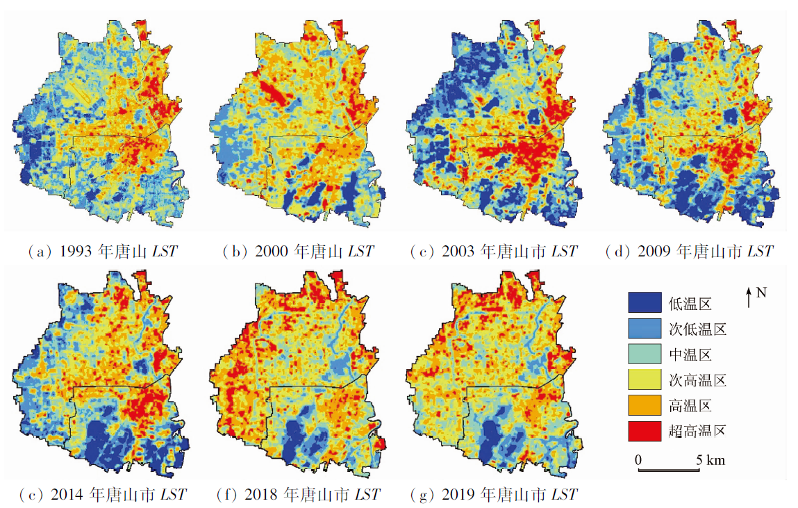
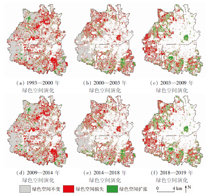
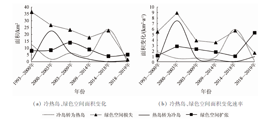
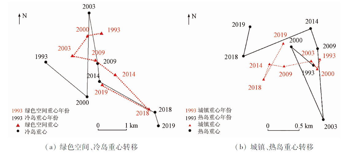
The urban environment is an important issue in the whole world, and the urban heat island (UHI) effect is one of the important research topics. Owing to the expansion of the urban area and the increase in population, the urban heat island effect has also significantly changed. With the Landsat imageries as the data source and the central urban area of Tangshan City, Hebei Province as the main study area, this study analyzed the impacts of green space evolution on urban temperature change using the methods such as the radiative transfer equation algorithm, supervised classification, gravity center shift, and random sampling. The results are as follows. ① During the study period, the development direction and area of UHIs were roughly consistent with the scale and direction of rapid urban development. Moreover, the migration directions of the gravity centers of the UCI/UHIs were similar to those of the green space and urban area, with the migration distance of the gravity centers of UCIs greater than that of the UHIs. ② The urban green space (UGS) has been continuously lost during the study period, with the largest loss area of approximately 55.79 km2 occurring in agricultural land. Moreover, the largest increased area occurred in urban land and was approximately 47.85 km2. ③ The evolutionary trends of UCIs/UHIs were inconsistent with those of the UGS in different periods. This result may be related to the stock of green space. ④ The cooling effect on the urban surface (-0.16 ℃) induced by green space expansion was much smaller than the warming effect on the urban surface (6.37 ℃) caused by green space loss. The research results will provide a reference for urban planning in order to rationally arrange green space, retain sufficient green space, and effectively reduce the development speed of UHIs.
王驷鹞, 赵春雷, 陈霞, 刘丹. 基于遥感的唐山市绿色空间演化及对热岛效应的影响[J]. 自然资源遥感, 2022, 34(2): 168-175.
WANG Siyao, ZHAO Chunlei, CHEN Xia, LIU Dan. Remote sensing-based green space evolution in Tangshan and its influence on heat island effect. Remote Sensing for Natural Resources, 2022, 34(2): 168-175.
Pan Y, Cui L L, Liu C M, et al. Spatiotemporal distribution of urban heat island effect based on MODIS data in Chongqing,China[J]. Chinese Journal of Ecology, 2018, 37(12):3736-3745.
Wang W J, Shen W M, Liu X M, et al. Research on the relation of the urbanization and urban heat island effect changes in Beijing based on remote sensing[J]. Research of Environmental Sciences, 2006, 19(2):44-48.
Zhang Y, Bao W J, Yu Q, et al. Study on seasonal variations of the urban heat island and its interannual changes in a typical Chinese megacity[J]. Chinese J Geophys, 2012, 55(4):1121-1128. (in Chinese)
Liu H, Shen G, Huang Q, et al. Evolution of urban heat island effect and its relationship with land use change in Wuhan City in recent 10 years[J]. Resources and Environment in the Yangtze Basin, 2017, 26(9):1466-1475.
[6]
Ren Z B, He X Y, Zheng H F, et al. Estimation of the relationship between urban park characteristics and park cool island intensity by remote sensing data and field measurement[J]. Forests, 2013, 4(4): 868-886.
doi: 10.3390/f4040868
Hua L Z, Sun F Q, Chen J N, et al. Quantifying the cool-island effects of urban parks using Landsat-8 imagery in a coastal city,Xiamen,China[J]. Acta Ecologica Sinica, 2020, 40(22): 8147-8157.
[8]
Jaganmohan M, Knapp S, Buchmann C M, et al. The bigger,the better? The influence of urban green space design on cooling effects for residential areas[J]. Journal of Environmental Quality, 2016, 45(1):134-145.
doi: 10.2134/jeq2015.01.0062
[9]
Ren Y, Deng L Y, Zuo S D, et al. Quantifying the influences of various ecological factors on land surface temperature of urban forests[J]. Environmental Pollution, 2016, 216:519-529.
doi: 10.1016/j.envpol.2016.06.004
Yang Y P, Cao G Z, Hou P, et al. Monitoring and evaluation for climate regulation service of urban wetlands with remote sensing[J]. Geographical Research, 2013, 32(1):73-80.
Chen X, Li L, Wang J, et al. Heat island effect mitigation by urban green space system:A case study of Taizhou City[J]. Ecology and Environmental Sciences, 2015, 24(4):643-649.
Wang X J, Wei X, Zou H. Research progress about the impact of urban green space spatial pattern on urban heat island[J]. Ecology and Environmental Sciences, 2000, 29(9): 1904-1911.
[13]
Ji Q, Yu M. Studying dynamical monitoring of heat island effect based on MODIS data in coastal cities of southeast Fujian Province[C]. Urban Remote Sensing Joint Event. Shanghai: IEEE, 2009.
[14]
Zhang J H, Yao F M. The characteristics of urban heat island variation in Beijing urban area and its impact factors[C]. Urban Remote Sensing Joint Event. Shanghai: IEEE, 2009.
[15]
Zhang X P, Wang D X, Hao H K, et al. Effects of land use/cover changes and urban forest configuration on urban heat islands in a loess hilly region:Case study based on Yan’an City,China[J]. International Journal of Environmental Research and Public Health, 2017, 14(8):840.
doi: 10.3390/ijerph14080840
[16]
Li B Y, Wang W, Bai L, et al. Effects of spatio-temporal landscape patterns on land surface temperature:A case study of Xi’an City,China[J]. Environmental Monit Assess, 2018, 190:419.
doi: 10.1007/s10661-018-6787-z
[17]
Liu K, Su H B, Li X K, et al. Quantifying spatial-temporal pattern of urban heat island in Beijing:An improved assessment using land surface temperature (LST) time series observations from Landsat,MODIS,and Chinese new satellite GaoFen-1[J]. IEEE Journal of Selected Topics in Applied Earth Observations & Remote Sensing, 2015:1939-1404.
[18]
Du H Y, Cai W B, Xu Y Q, et al. Quantifying the cool island effects of urban green spaces using remote sensing data[J]. Urban Forestry & Urban Greening, 2017, 27:24-31.
[19]
Ngulani T, Shackleton C M. The degree,extent and value of air temperature amelioration by urban green spaces in Bulawayo,Zimbabwe[J]. The South African Geographical Journal, 2019, 102(3):344-355.
doi: 10.1080/03736245.2019.1685405
[20]
Estoque R C, Murayama Y, Myint S W. Effects of landscape composition and pattern on land surface temperature:An urban heat island study in the megacities of Southeast Asia[J]. Science of the Total Environment, 2016, 577:349-359.
doi: 10.1016/j.scitotenv.2016.10.195
[21]
Li X M, Zhou W Q. Optimizing urban greenspace spatial pattern to mitigate urban heat island effects:Extending understanding from local to the city scale[J]. Urban Forestry & Urban Greening, 2019, 41:255-263.
Zhang S, Liu Y H, Huang H T. Research on quantitative evaluations and spatial and temporal distribution of heat islands for the Pearl River Delta agglomeration[J]. Ecology and Environmental Sciences, 2017, 26(7): 1157-1166.
Chen Y H, Cai Y B, Tong C. Temperature effect under the green space evolution based on remote sensing:A case study of Fuzhou,China[J]. Acta Ecologica Sinica, 2020, 40(7):2439-2449.
[24]
唐山市人民政府. 唐山统计年鉴[M]. 北京: 中国统计出版社, 2019.
Tangshan Municipal People’s Government. Tangshan statistical yearbook[M]. Beijing: China Statistics Press, 2019.
Zhang X R, Chen C, Dong K. Analysis of temporal and spatial characteristics of land use pattern in Tangshan coastal zone from 1956 to 2005 based on RS and GIS[J]. Acta Agriculturae Boreali-occidentalis Sinica, 2013, 22(2):204-208.
Jin D D, Gong Z N. Algorithms comparison of land surface temperature retrieval from Landsat series data:A case study in Qiqihar,China[J]. Remote Sensing Technology and Application, 2018, 33(5): 830-841.
Qin Z H, Zhang M H, Arnon Karnieli, et al. Mono-window algorithm for retrieving land surface temperature from Landsat TM6 data[J]. Acta Geographica Sinica, 2001, 56(4):456-466.
doi: 10.11821/xb200104009
[28]
Jiménez‐Muñoz J C, Sobrino J A. A generalized single-channel method for retrieving land surface temperature from remote sensing data[J]. Journal of Geophysical Research, 2003, 108(D22):2015-2023.
Mao K B, Tang H J, Zhou Q B, et al. Retrieving land surface temperature from MODIS data by using radiance transfer equation[J]. Journal of Lanzhou University(Natural Sciences), 2007, 43(4):12-17.
[30]
Rozenstein O, Qin Z H, Derimian Y, et al. Derivation of land surface temperature for Landsat-8 TIRS using a split window algorithm[J]. Sensors, 2014, 14(4):5768-5780.
doi: 10.3390/s140405768
pmid: 24670716
Qin Z H, Li W J, Xu B, et al. The estimation of land surface emissivity for Landsat TM6[J]. Remote Sensing for Land and Resources, 2004, 61(3):28-30.doi: 10.6046/gtzyyg.2004.03.07.
doi: 10.6046/gtzyyg.2004.03.07
Song T, Duan Z, Liu J Z, et al. Comparison of four algorithms to retrieve land surface temperature using Landsat 8 satellite[J]. Journal of Remote Sensing, 2015, 19(3):451-464.
[33]
Peng J, Xie P, Liu Y X, et al. Urban thermal environment dynamics and associated landscape pattern factors: A case study in the Beijing metropolitan region[J]. Remote Sensing of Environment, 2016, 173:145-155.
doi: 10.1016/j.rse.2015.11.027
 2022, Vol. 34
  ), 赵春雷2,3, 陈霞4, 刘丹5(