PS-InSAR-based monitoring and analysis of surface subsidence in Shanghai
ZHANG Zhihua1,2,3(), HU Changtao1,2,3, ZHANG Zhen1,2,3, YANG Shuwen1,2,3
1. Faculty of Geomatics, Lanzhou Jiaotong University, Lanzhou 730070, China 2. National-Local Joint Engineering Research Center of Technologies and Applications for National Geographic State Monitoring, Lanzhou 730070, China 3. Gansu Provincial Engineering Laboratory for National Geographic State Monitoring, Lanzhou 730070, China
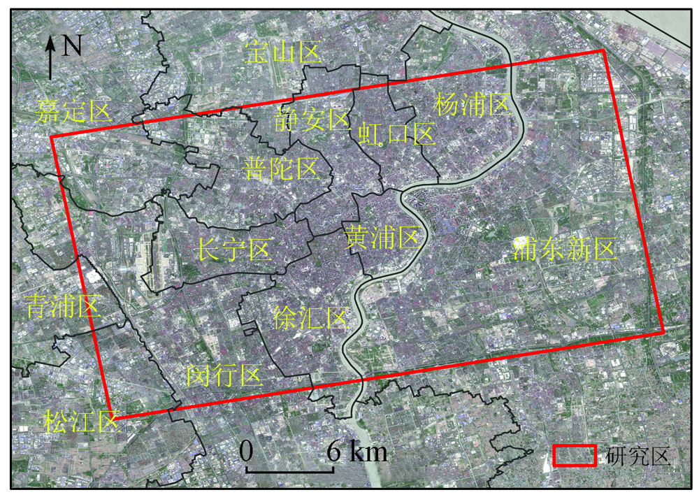
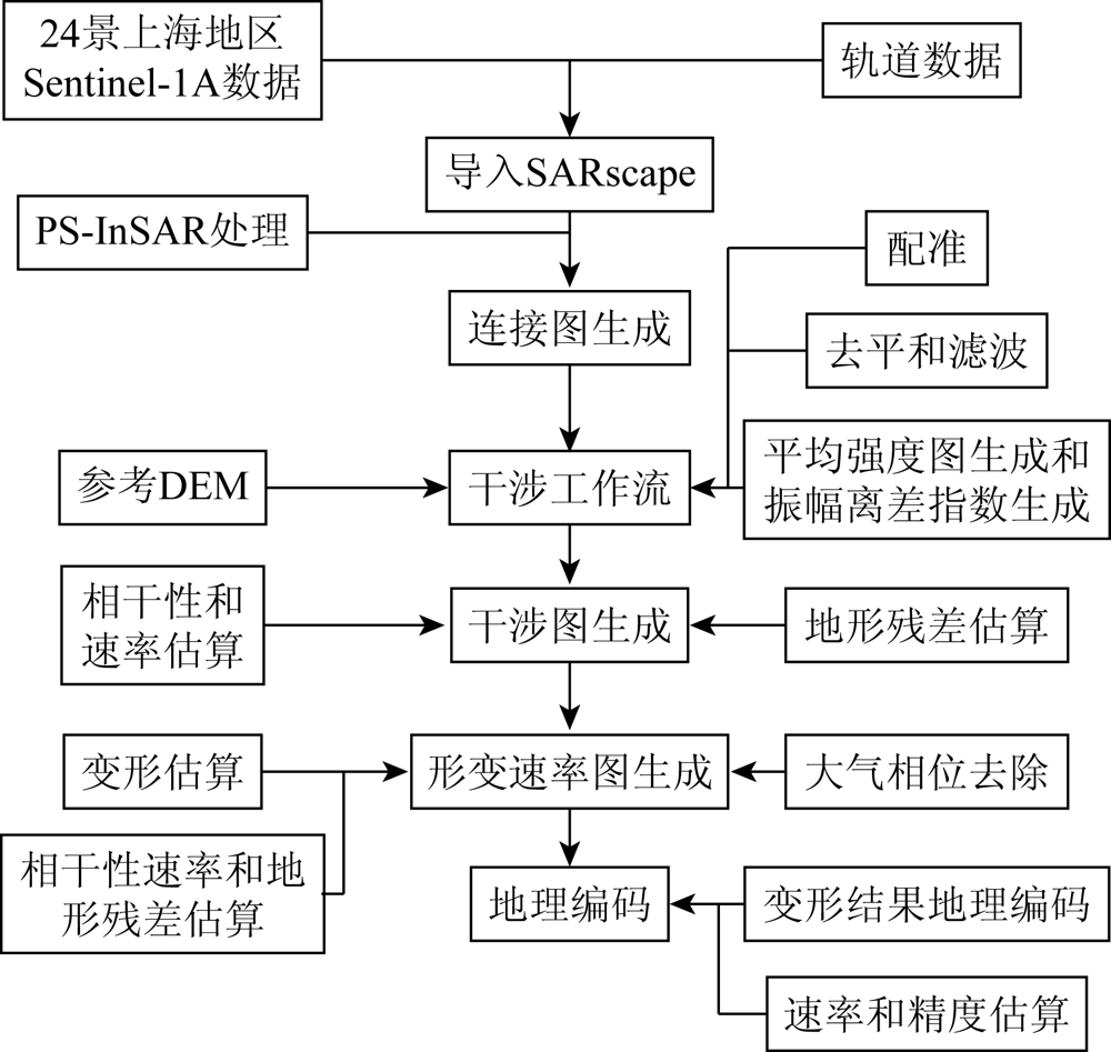
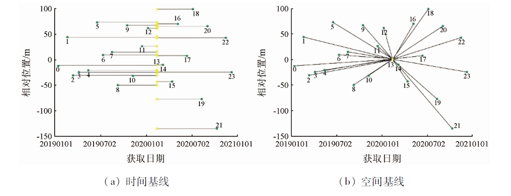
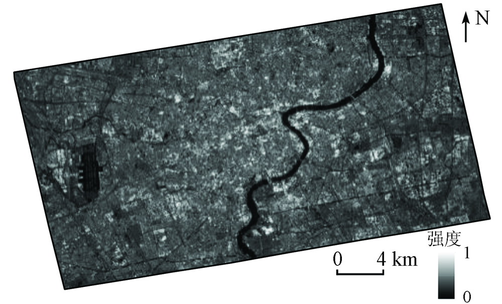
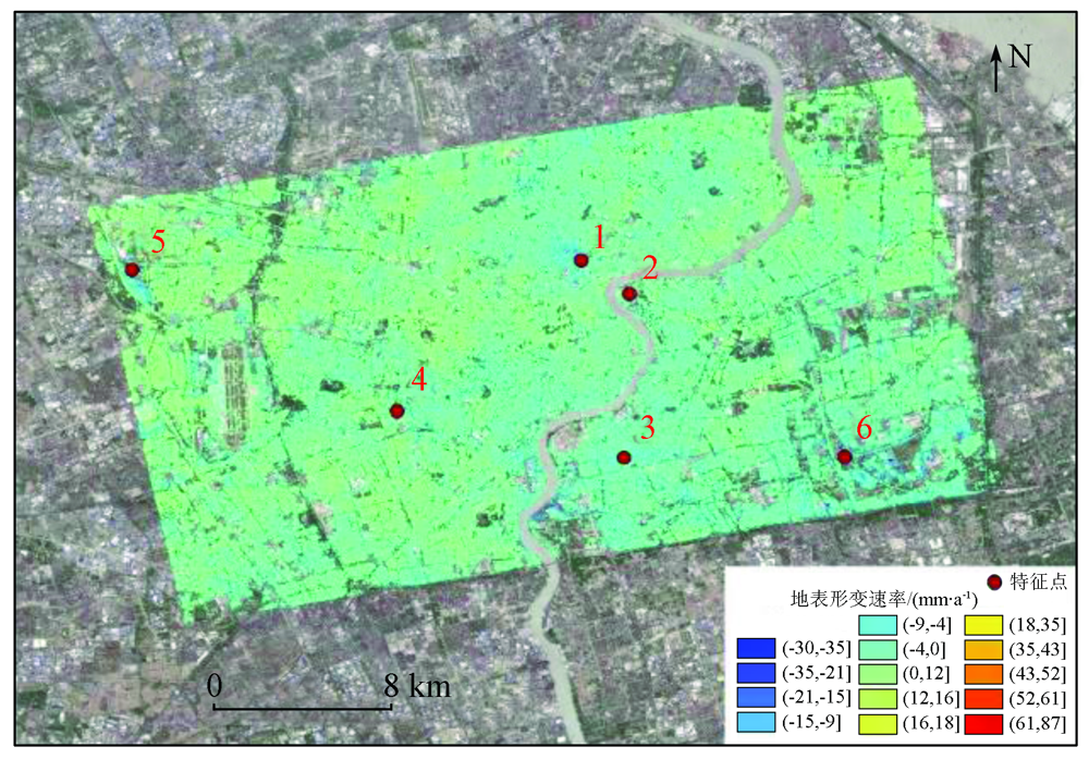
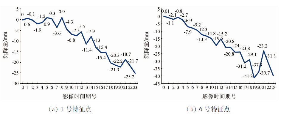
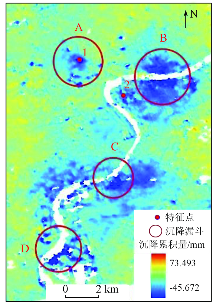
Urban surface subsidence has increasingly severe impacts on human life, making it particularly important to study the methods for effectively monitoring surface subsidence. To monitor the surface subsidence in Shanghai, this study processed 24 scenes of 2019—2020 Sentinel-1A data covering the city using the PS-InSAR technique. After treatment using the permanent scatterer interferometry technique, the residual phase correction was performed using SRTM1 DEM, and the surface subsidence results of the two years were extracted. The analysis of the subsidence rate and cumulative subsidence amplitude in the monitoring results shows that the urban area mainly shows uneven surface subsidence with multiple subsidence funnels, some of which correspond to the historical subsidence data. As shown by time-series surface subsidence data of seldomly selected ground characteristic points, the surface subsidence at these points basically had the same deformation amplitude at different times and highly consistent changing trends, verifying the reliability of the PS-InSAR monitoring method. The results of this study will provide data and decision-making bases for geologic disaster prevention and control in Shanghai.
Wang B C, Zhu L, Pan D, et al. Research on temporal and spatial evolution law of land subsidence in Zhengzhou[J]. Remote Sensing for Land and Resources, 2020, 32(3):143-148.doi: 10.6046/gtzyyg.2020.03.19.
doi: 10.6046/gtzyyg.2020.03.19
[3]
Yang Q, Ke Y H, Zhang D Y, et al. Multi-Scale analysis of the relationship between land subsidence and buildings:A case study in an eastern Beijing urban area using the PS-InSAR technique[J]. Remote Sensing, 2018, 10(7):1006.
doi: 10.3390/rs10071006
[4]
Lyu M Y, Ke Y H, Guo L, et al. Change in regional land subsidence in Beijing after south-to-north water diversion project observed using satellite Radar interferometry[J]. GIScience and Remote Sensing, 2020, 57(1):140-156.
doi: 10.1080/15481603.2019.1676973
Yan Y. Ground subsidence monitoring and mechanism analysis in Haikou area based on SBAS-InSAR technology[D]. Beijing: China University of Geosciences(Beijing), 2020.
Nie Y J, Liu G X, Shi J F, et al. Ground subsidence of Shanghai from 2009 to 2010 monitored by PSI technique[J]. Remote Sensing Information, 2013, 28(2):56-61.
[7]
Ferretti A, Prati C, Rocca F. Nonlinear subsidence rate estimation using permanent scatterers in differential SAR interferometry[J]. IEEE Transactions on Geoscience and Remote Sensing, 2000, 38(5):2202-2212.
doi: 10.1109/36.868878
Gao E T, Fan D L, Fu B L. Land subsidence monitoring of Nanjing area based on PS-InSAR and SBAS technology[J]. Geodesy and Geodynamics, 2019, 39(2):158-163.
Ma Y Y, Zou X Q, Ma W F. Settlement monitoring and analysis of Tianjin area based on PS-InSAR[J]. Remote Sensing Technology and Application, 2019, 34(6):1324-1331.
Liu X, Shang A R. Application contrast of PS-InSAR and SBAS-InSAR in urban surface subsidence monitoring[J]. GNSS World of China, 2016, 41(2):101-105.
[11]
上海市统计局. 上海统计年鉴2020[M]. 北京: 中国统计出版社, 2020.
Shanghai Municipal Bureau of Statistics. Shanghai statistical yearbook 2020[M]. Beijing: China Statistics Press, 2020.
[12]
Cigna F, Tapete D. Present-day land subsidence rates,surface faulting hazard and risk in Mexico City with 2014—2020 Sentinel-1 IW InSAR[J]. Remote Sensing of Environment, 2021, 253:1-19.
Zhang Z X. Research on settlement monitoring of high speed railway based on PS-InSAR technology[D]. Beijing: China University of Geosciences(Beijing), 2016.
[14]
Dumka R K, SuriBabu D, Malik K, et al. PS-InSAR derived deformation study in the Kachchh,Western India[J]. Applied Computing and Geosciences, 2020, 8:1-8.
Xiong J C, Nie Y J, Luo Y, et al. Monitoring urban land subsidence by dual-polarization Sentinel-1 data:A case study of Shanghai[J]. Bulletin of Surveying and Mapping, 2019(11):98-102,129.
Shi Y J. Recent characteristics of land subsidence in Shanghai and its effect on performance of key municipal facilities[D]. Shanghai: Shanghai Jiao Tong University, 2018.
Zhu J Y. Research on land subsidence mechanism and prediction of settlement in Cangzhou area[D]. Beijing: China University of Geosciences(Beijing), 2014.
 2022, Vol. 34
  ), 胡长涛1,2,3, 张镇1,2,3, 杨树文1,2,3