Intelligent detection of crab ponds using remote sensing images based on a cooperative interpretation mechanism
JIANG Zhuoran1(), ZHOU Xinxin2,3,4, CAO Wei5, WANG Yahua1,3,4, WU Changbin1,3,4()
1. School of Geography, Nanjing Normal University, Nanjing 210023, China 2. School of Geographic and Biologic Information, Nanjing University of Posts and Telecommunications, Nanjing 210023, China 3. Key Lab of Virtual Geographic Environment, Ministry of Education, Nanjing Normal University, Nanjing 210023, China 4. Jiangsu Center for Collaborative Innovation in Geographical Information Resource Development and Application, Nanjing 210023,China 5. Nanjing Guotu Information Industry Co., Ltd., Nanjing 210000, China
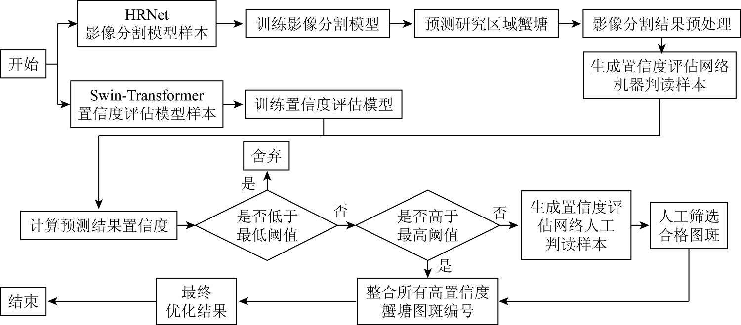
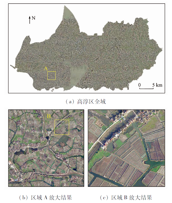
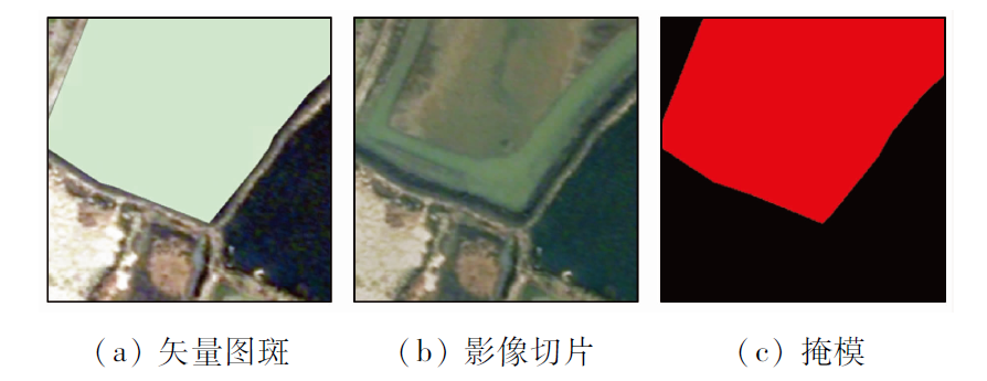
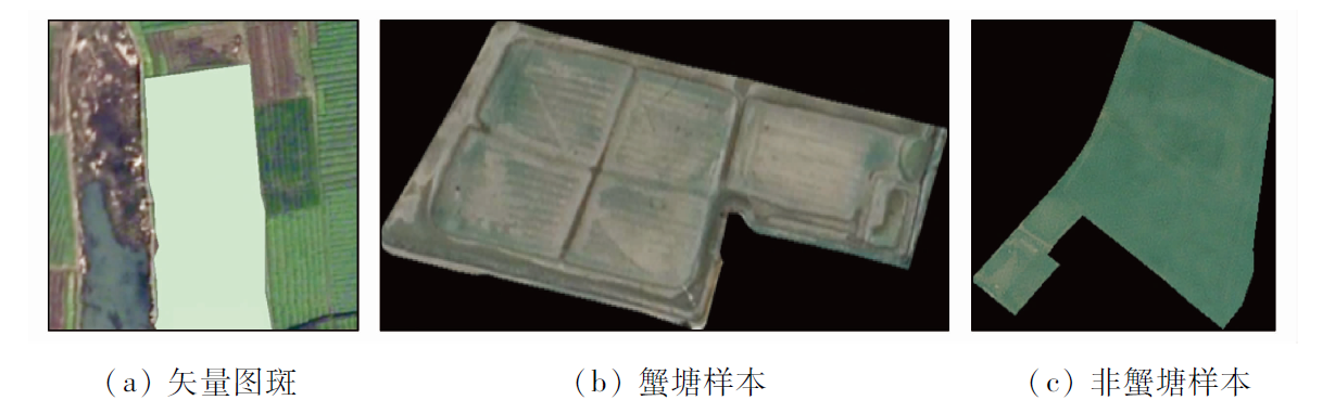
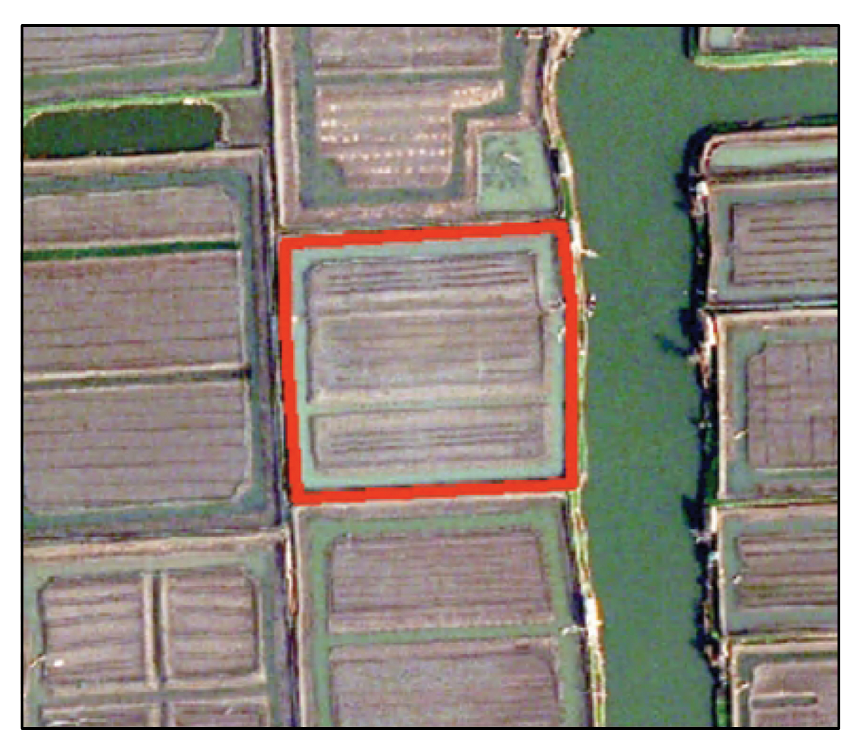
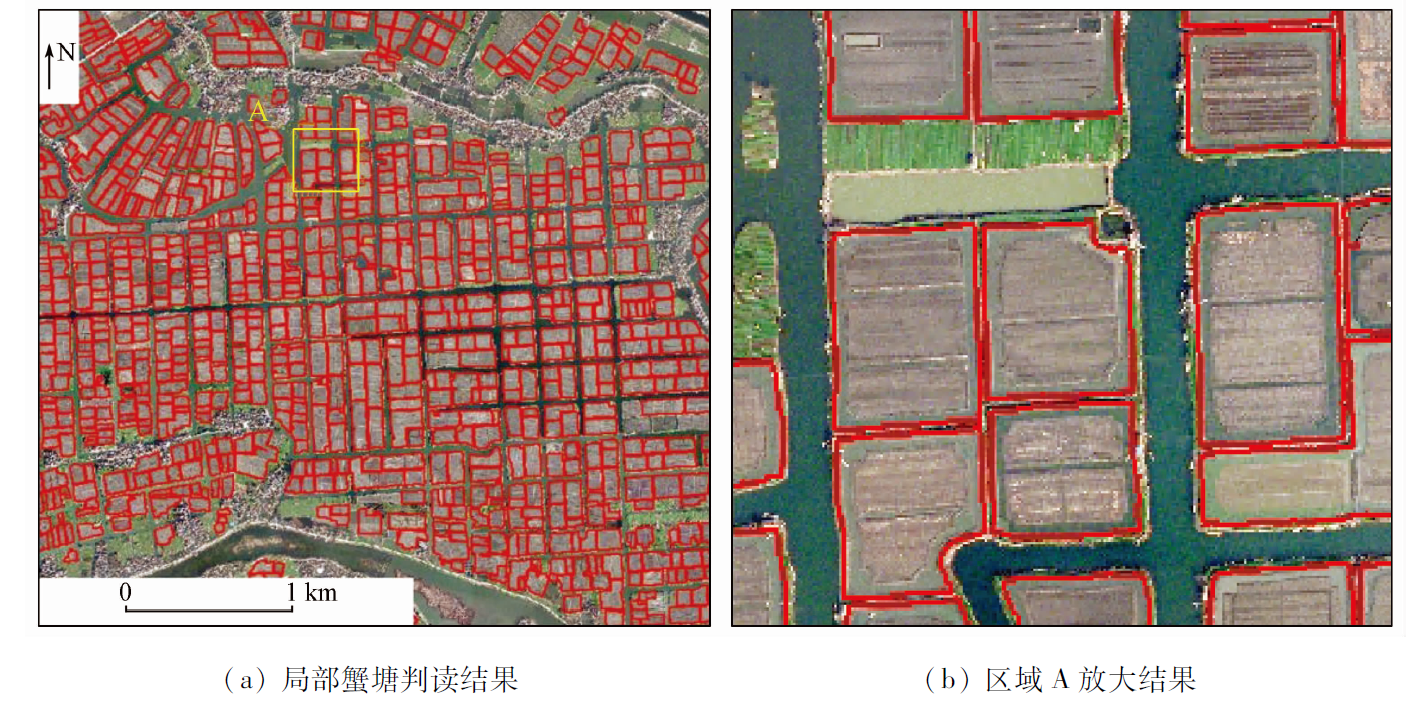
Digging ponds to raise crabs is a non-grain behavior of cultivated land, endangering national food security. However, the intelligent interpretation of remote sensing images targeting this behavior faces challenges such as laborious manual interpretation and low verification efficiency. Based on a cooperative interpretation mechanism, this study proposed an intelligent method for detecting crab ponds using remote sensing images. This method, integrating the HRNet segmentation network and the Swin-Transformer classification network models and combining manual verification, improved the detection accuracy and work efficiency. The application results of this method to Gaochun District, Nanjing City, Jiangsu Province show that the method for intelligent detection can automatically determine 83.4% of the spots for detection, with final identification accuracy of 0.972. The method proposed in this study can significantly reduce the identification difficulty and manual verification workload while improving the detection accuracy. Therefore, this study will provide a reliable solution for the accurate and efficient detection of non-grain surface features such as crab ponds.
Yang R Z, Chen Y J, Yi X Y, et al. The causes and countermeasures on the excessive “non-food” tendency in the process of land transfer[J]. Chinese Journal of Agricultural Resources and Regional Planning, 2012, 33(3):14-17.
Wang Y, Chen Y J, Yi X Y, et al. The non-grain problem in the process of land transfer and the countermeasures[J]. Chinese Journal of Agricultural Resources and Regional Planning, 2011, 32(4):13-16.
Kuang Y P, Liu Y. Distingushing “non-agriculturalization” and “non-grainification” in the process of rural land transfer[J]. Rural Economy, 2018(4):1-6.
Li X J, Meng Q Y, Wang C M, et al. A hybrid model of object-oriented and pixel based classification of remotely sensed data[J]. Journal of Geo-Information Science, 2013, 15(5):744-751.
doi: 10.3724/SP.J.1047.2013.00744
Zhang J X, Gu H Y, Yang Y, et al. Research progress and trend of high-resolution remote sensing imagery intelligent interpretation[J]. National Remote Sensing Bulletin, 2021, 25(11):2198-2210.
doi: 10.11834/jrs.20210382
[6]
Blaschke T. Object based image analysis for remote sensing[J]. ISPRS Journal of Photogrammetry and Remote Sensing, 2010, 65(1):2-16
doi: 10.1016/j.isprsjprs.2009.06.004
[7]
Ma L, Li M, Ma X X, et al. A review of supervised object-based land-cover image classification[J]. ISPRS Journal of Photogrammetry and Remote Sensing, 2017, 130:277-293.
doi: 10.1016/j.isprsjprs.2017.06.001
Zhang Y, Yang H T, Yuan C H. A survey of remote sensing image classification methods[J]. Journal of Ordnance Equipment Engineering, 2018, 39(8):108-112.
Wei F M, Li X W, Gu X F, et al. Shape-based classification of “spectral similar” objects in remote sensing image processing[C]// Proceedings of the 14th National Conference on Image Graphics, 2008:477-481.
Li G Q, Bo Y Q, Yang X, et al. Automatic deep learning land cover classification methods of high-resolution remotely sensed images[J]. Journal of Geo-Information Science, 2021, 23(9):1690-1704.
Wang L G, Wang L F. Variety identification model for maize seeds using hyperspectral pixel-level information combined with convolutional neural network[J]. National Remote Sensing Bulletin, 2021, 25(11):2234-2244.
doi: 10.11834/jrs.20219349
[13]
Zhang L P, Zhang L F, Du B. Deep learning for remote sensing data: A technical tutorial on the state of the art[J]. IEEE Geoscience and Remote Sensing Magazine, 2016, 4(2):22-40.
doi: 10.1109/MGRS.2016.2540798
Wang H J, Ge X S. Lightweight DeepLabv3+ building extraction method from remote sensing images[J]. Remote Sensing for Natural Resources, 2022, 34(2):128-135.doi:10.6046/zrzyyg.2021219.
doi: 10.6046/zrzyyg.2021219
Liu W J, Gao J K, Qu H C, et al. Ship detection based on multi-scale feature enhancement of remote sensing images[J]. Remote Sensing for Natural Resources, 2021, 33(3): 97-106.doi:10.6046/zrzyyg.2020372.
doi: 10.6046/zrzyyg.2020372
Yu X L, Song Y, Yang M, et al. Multi-model and multi-scale scene recognition of shipbuilding enterprises based on convolutional neural network with spatial constraints[J]. Remote Sensing for Natural Resources, 2021, 33(4):72-81.doi:10.6046/zrzyyg.2021020.
doi: 10.6046/zrzyyg.2021020
[17]
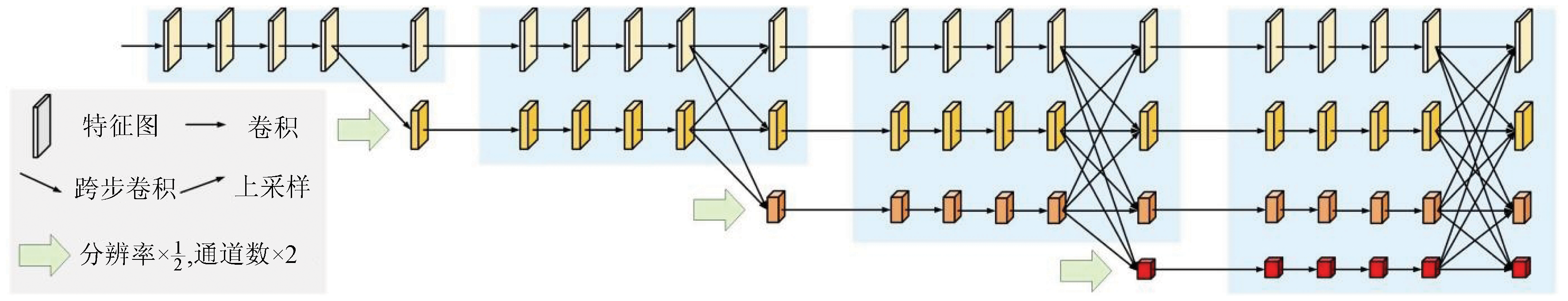
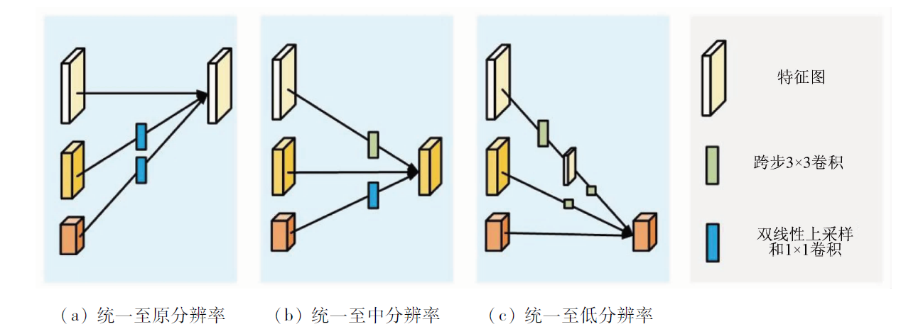
Sun K, Xiao B, Liu D, et al. Deep high-resolution representation learning for human pose estimation[C]// Proceedings of the IEEE/CVF Conference on Computer Vision and Pattern Recognition (CVPR), 2019:5693-5703.
[18]
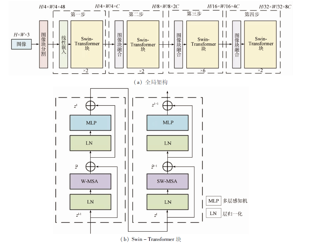
Liu Z, Lin Y, Cao Y, et al. Swin transformer: Hierarchical vision transformer using shifted windows[C]// Proceedings of the IEEE/CVF International Conference on Computer Vision(CVPR), 2021:10012-10022.
Diao Z H, Zhao C J, Wu G, et al. Application research of mathematical morphology in image processing of crop disease[J]. Journal of Image and Graphics, 2010, 15(2):194-199.
[21]
Yang K, Zeng L B, Wang D C. A fast arithmetic for the erosion and dilation operations of mathematical morphology[J]. Computer Engineering and Applications, 2005, 41(34):54-56.
[22]
Vaswani A, Shazeer N, Parmar N, et al. Attention is all you need[C]// Proceedings of the 31st International Conference on Neural Information Processing Systems, 2017:6000-6010.
[23]
He K, Zhang X, Ren S, et al. Deep residual learning for image reco-gnition[C]// 2016 IEEE Conference on Computer Vision and Pattern Recognition (CVPR),2016.
 2023, Vol. 35
  ), 周鑫鑫2,3,4, 曹伟5, 王亚华1,3,4, 吴长彬1,3,4(