Remote sensing information extraction for mangrove forests based on multi-feature parameters: A case study of Guangdong Province
WANG Yumiao1,2(), LI Sheng1,3, DONG Chunyu2, YANG Gang2()
1. Key Laboratory of Urban Land Resources Monitoring and Simulation, Ministry of Natural Resources, Shenzhen 518000, China 2. Department of Geography and Spatial Information Techniques, Ningbo University, Ningbo 315211, China 3. Shenzhen Data Management Center of Planning and Natural Resource, Shenzhen 518000, China
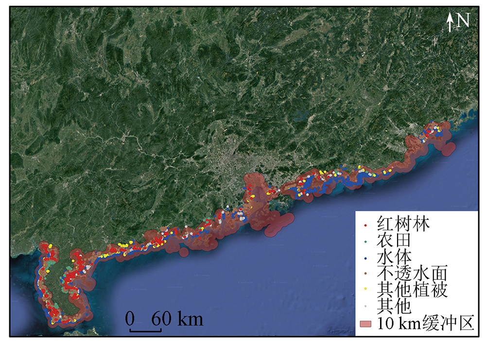
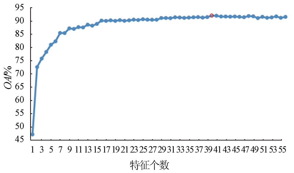
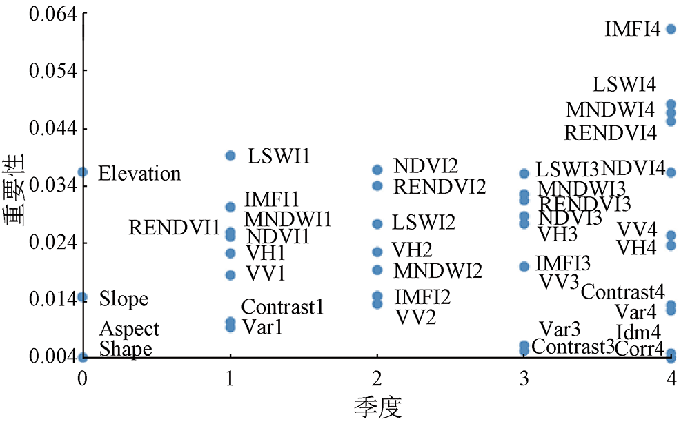
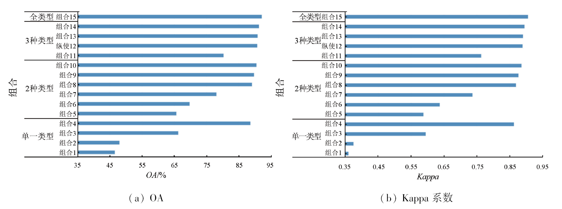
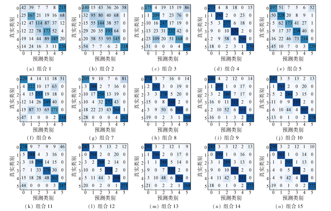
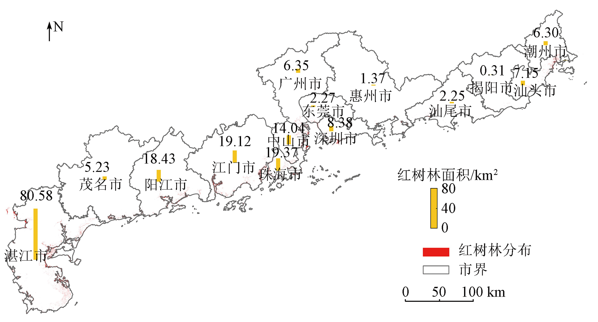
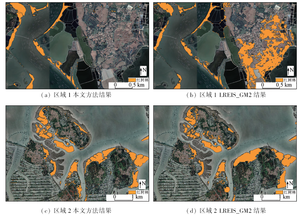
Accurate mangrove forest distribution information is critical to the conservation and management of mangrove forests. Despite extensive studies on the remote sensing mapping of mangrove forests, it is necessary to improve their mapping accuracy by effectively utilizing multi-source remote sensing features. First, this study designed 15 feature associations using temporal features, including spectral, scattering, texture, and terrain features, which were extracted from multi-source remote sensing data. Then, using a random forest model, it analyzed the accuracy of different feature associations in mangrove forest identification, obtaining the optimal feature association. Finally, this study mapped the 10-m-resolution mangrove forest distribution of Guangdong Province in 2021 based on platform Google Earth Engine (GEE). The results show that spectral features in winter exhibited the highest importance, with richer feature types corresponding to higher mapping accuracy. The optimal feature association yielded overall accuracy of 92.25% and a Kappa value of 0.91. Overall, this study extracted information on mangrove forests in Guangdong based on multi-feature parameters and the optimal feature association. The results of this study will provide a scientific reference for accurate mapping of mangrove forests on a large scale.
王煜淼, 李胜, 东春宇, 杨刚. 多特征参数支持的红树林遥感信息提取——以广东省为例[J]. 自然资源遥感, 2024, 36(1): 95-102.
WANG Yumiao, LI Sheng, DONG Chunyu, YANG Gang. Remote sensing information extraction for mangrove forests based on multi-feature parameters: A case study of Guangdong Province. Remote Sensing for Natural Resources, 2024, 36(1): 95-102.
Pastor-Guzman J, Dash J, Atkinson P M. Remote sensing of mangrove forest phenology and its environmental drivers[J]. Remote Sensing of Environment, 2018, 205:71-84.
doi: 10.1016/j.rse.2017.11.009
He B Y, Fan H Q, Wang M, et al. Species diversity in mangrove wetlands of China and its causation analyses[J]. Acta Ecologica Sinic, 2007, 27(11): 4859-4870.
Zhang H, Wang S X, Zhou Y, et al. Comparison of different metho-ds of mangrove extraction from multi-source remote sensing images[J]. Wetland Science, 2015, 13(2):145-152.
Mai S Z, Xu S J. Protection and development of mangrove resources in Guangdong Province[J]. Ocean Development and Management, 2005, 22(1):44-48.
[5]
Giri C. Observation and monitoring of mangrove forests using remote sensing:Opportunities and challenges[J]. Remote Sensing, 2016, 8(9):783.
doi: 10.3390/rs8090783
[6]
Kirui K B, Kairo J G, Bosire J, et al. Mapping of mangrove forest land cover change along the Kenya coastline using Landsat imagery[J]. Ocean and Coastal Management, 2013, 83:19-24.
doi: 10.1016/j.ocecoaman.2011.12.004
[7]
Warfield A D, Leon J X. Estimating mangrove forest volume using terrestrial laser scanning and UAV-derived structure-from-motion[J]. Drones, 2019, 3(2):32.
doi: 10.3390/drones3020032
Xu Y, Zhen J N, Jiang X P, et al. Mangrove species classification with UAV-based remote sensing data and XGBoost[J]. National Remote Sensing Bulletin, 2021, 25(3):737-752.
doi: 10.11834/jrs.20210281
Wang Z Y, Liu K, Peng L H, et al. Analysis of mangrove annual changes in Guangdong Province during 1986—2018 based on Google Earth Engine[J]. Tropical Geography, 2020, 40(5):881-892.
[10]
Jia M, Wang Z, Wang C, et al. A new vegetation index to detect periodically submerged mangrove forest using single-tide Sentinel-2 imagery[J]. Remote Sensing, 2019, 11(17):2043.
doi: 10.3390/rs11172043
[11]
Jia M, Wang Z, Li L, et al. Mapping China’s mangroves based on an object-oriented classification of Landsat imagery[J]. Wetlands, 2014, 34(2):277-283.
doi: 10.1007/s13157-013-0449-2
[12]
Ma C, Ai B, Zhao J, et al. Change detection of mangrove forests in coastal Guangdong during the past three decades based on remote sensing data[J]. Remote Sensing, 2019, 11(8):921.
doi: 10.3390/rs11080921
[13]
Xiao H, Su F Z, Fu D J, et al. 10-m global mangrove classification products of 2018—2020[DS/OL]. Science Data Bank, 2021[2022-12-09].http://doi.org/10.11922/sciencedb.01019.
Deng J W, Tian Y C, Zhang Q, et al. Application of airborne LiDAR in the estimation of the mean height of mangrove stand[J]. Remote Sensing for Natural Resources, 2022, 34(3):129-137.doi: 10.6046/zrzyyg.2021237.
[15]
Gorelick N, Hancher M, Dixon M, et al. Google Earth Engine:Planetary-scale geospatial analysis for everyone[J]. Remote Sensing of Environment, 2017, 202:18-27.
doi: 10.1016/j.rse.2017.06.031
[16]
Zhao C, Qin C Z. 10-m-resolution mangrove maps of China derived from multi-source and multi-temporal satellite observations[J]. ISPRS Journal of Photogrammetry and Remote Sensing, 2020, 169:389-405.
doi: 10.1016/j.isprsjprs.2020.10.001
[17]
Peng Y, Zheng M, Zheng Z, et al. Virtual increase or latent loss? A reassessment of mangrove populations and their conservation in Guangdong,southern China[J]. Marine Pollution Bulletin, 2016, 109(2):691-699.
doi: 10.1016/j.marpolbul.2016.06.083
Wu P Q, Ma Y, Li X M, et al. Remote sensing monitoring of the mangrove forests resources of Guangdong Province[J]. Journal of Marine Sciences, 2011, 29(4):16-24.
Jiang N, Chen C, Han H F. An optimization method of DEM resolution for land type statistical model of coastal zones[J]. Remote Sensing for Natural Resources, 2022, 34(1):34-42.doi: 10.6046/zrzyyg.2022005.
[20]
Farr T G, Rosen P A, Caro E, et al. The shuttle Radar topography mission[J]. Reviews of Geophysics, 2007, 45(2):361.
[21]
Tucker C J. Red and photographic infrared linear combinations for monitoring vegetation[J]. Remote Sensing of Environment, 1979, 8(2):127-150.
doi: 10.1016/0034-4257(79)90013-0
[22]
Xiao X, Boles S, Liu J, et al. Mapping paddy rice agriculture in southern China using multi-temporal MODIS images[J]. Remote Sensing of Environment, 2005, 95(4):480-492.
doi: 10.1016/j.rse.2004.12.009
[23]
Xu H. Modification of normalised difference water index (NDWI) to enhance open water features in remotely sensed imagery[J]. International Journal of Remote Sensing, 2006, 27(14):3025-3033.
doi: 10.1080/01431160600589179
Jia M M. Remote sensing analysis of China’s mangrove forests dynamics during 1973 to 2013[D]. Changchun: Northeast Institute of Geography and Agroecology,Chinese Academy of Sciences, 2014.
[25]
Lin S, Li J, Liu Q, et al. Evaluating the effectiveness of using vegetation indices based on red-edge reflectance from Sentinel-2 to estimate gross primary productivity[J]. Remote Sensing, 2019, 11(11):1303.
doi: 10.3390/rs11111303
He Z X, Zhang M, Wu B F, et al. Extraction of summer crop in Jiangsu based on Google Earth Engine[J]. Journal of Geo-Information Science, 2019, 21(5):752-766.
[27]
Naboureh A, Li A, Bian J, et al. A hybrid data balancing method for classification of imbalanced training data within Google Earth Engine:Case studies from mountainous regions[J]. Remote Sensing, 2020, 12(20):3301.
doi: 10.3390/rs12203301
[28]
Ghorbanian A, Kakooei M, Amani M, et al. Improved land cover map of Iran using Sentinel imagery within Google Earth Engine and a novel automatic workflow for land cover classification using migrated training samples[J]. ISPRS Journal of Photogrammetry and Remote Sensing, 2020, 167:276-288.
doi: 10.1016/j.isprsjprs.2020.07.013
[29]
Song Q, Hu Q, Zhou Q B, et al. In-season crop mapping with GF-1/WFV data by combining object-based image analysis and random forest[J]. Remote Sensing, 2017, 9(11):1184.
doi: 10.3390/rs9111184
[30]
Van Beijma S, Comber A, Lamb A. Random forest classification of salt marsh vegetation habitats using quad-polarimetric airborne SAR,elevation and optical RS data[J]. Remote Sensing of Environment, 2014, 149:118-129.
doi: 10.1016/j.rse.2014.04.010
 2024, Vol. 36
  ), 李胜1,3, 东春宇2, 杨刚2(