Spatiotemporal changes in land use and their driving factors in the Golmud River basin from 1980 to 2020
MA Maonan1,2(), CHANG Liang1, YU Guoqiang1(), ZHOU Jianwei3, HAN Haihui1, ZHANG Qunhui1, CHEN Xiaoyan1, DU Chao4
1. Xi’an Center, China Geological Survey, Xi’an 710119, China 2. Institute of Geological Survey, China University of Geosciences (Wuhan), Wuhan 430074, China 3. School of Environmental Studies, China University of Geosciences (Wuhan), Wuhan 430074, China 4. Geological Survey Academy of Inner Mongolia Autonomous Region, Hohhot 010020, China
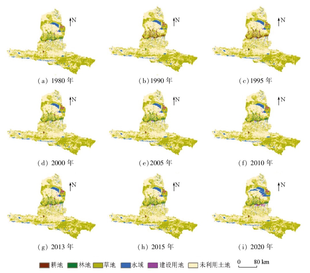
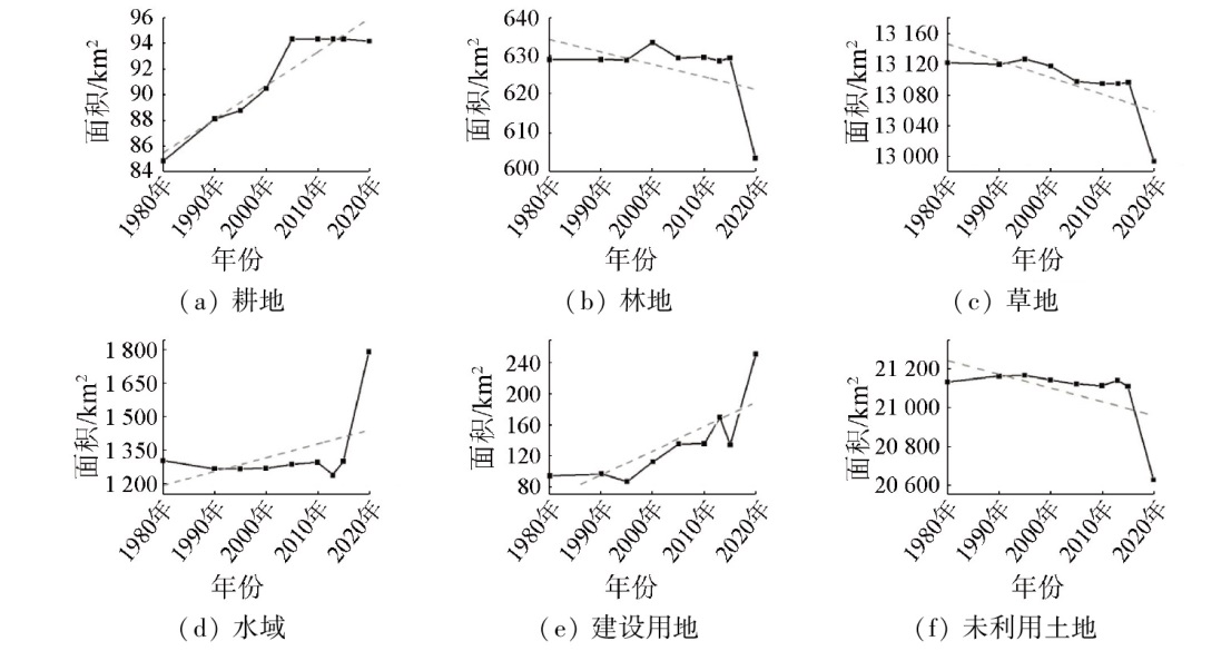
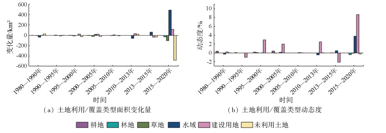
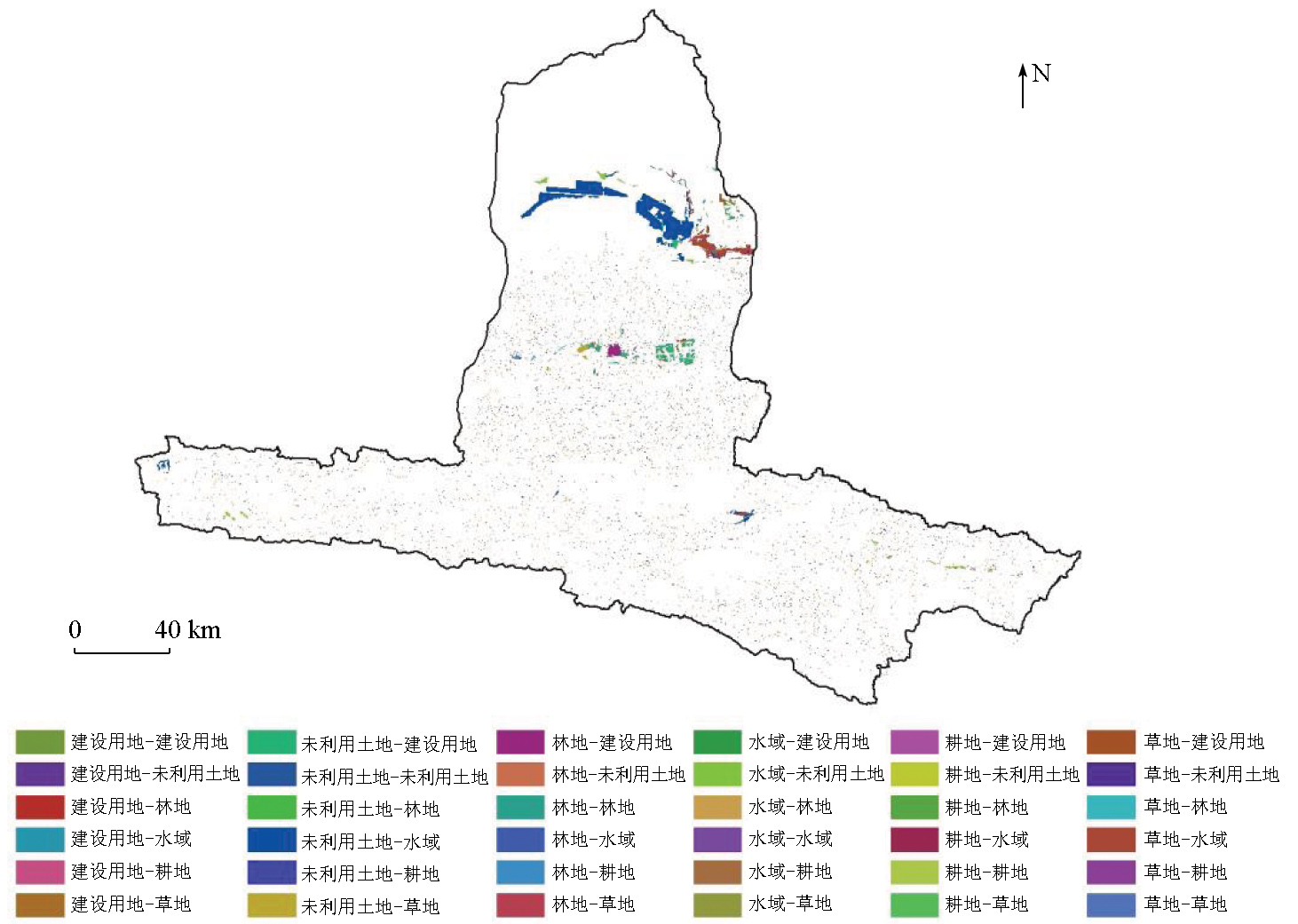
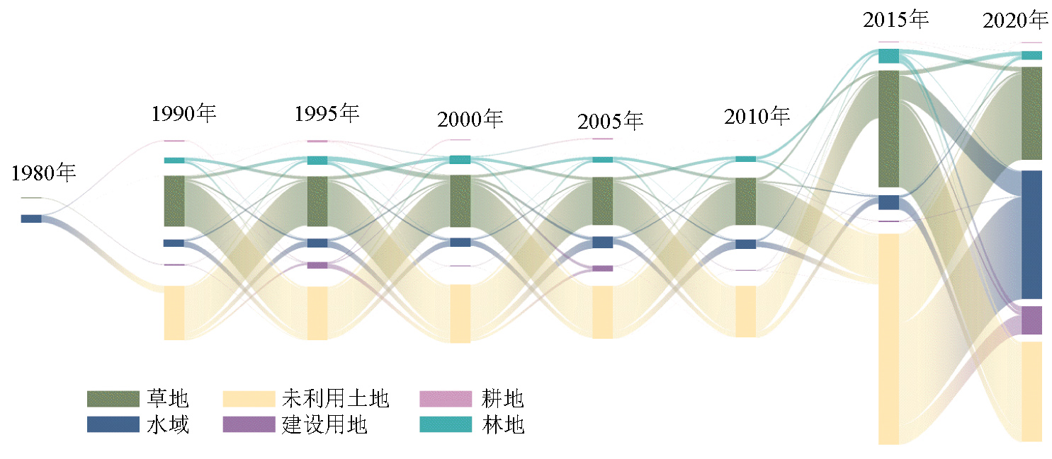
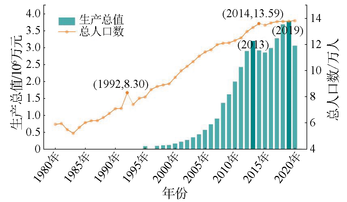
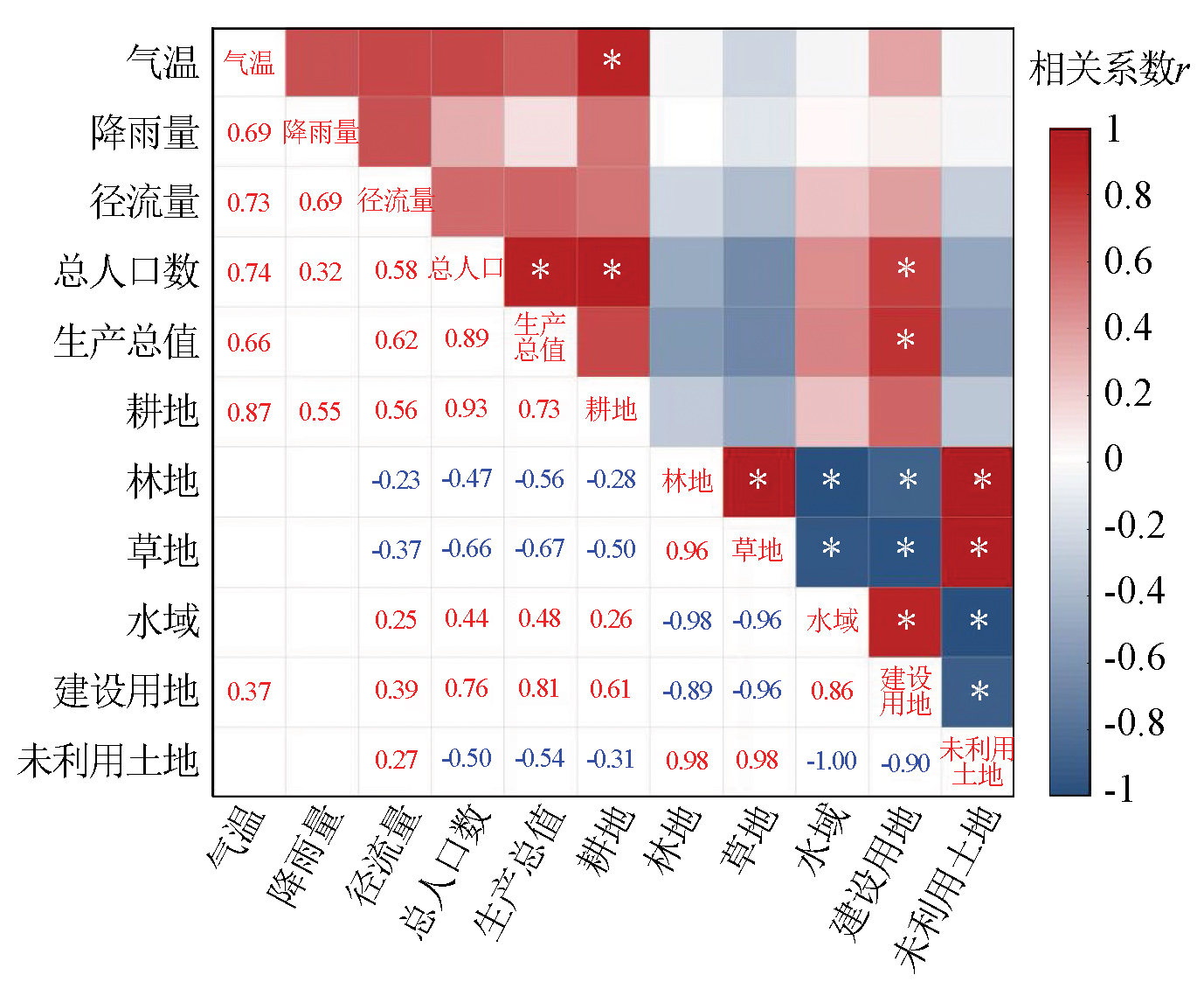
Land use serves as the primary cause of global environmental changes. Therefore, investigating its spatiotemporal changes and corresponding driving factors is significant for promoting the sustainable development of regional socioeconomics and ecosystems. Based on nine stages of remote sensing monitoring data on land use/land cover from 1980 to 2020, this study analyzed the spatiotemporal changes in land use types in the Golmud River basin. By combining the analysis of significant correlations, this study explored the major factors driving changes in land use within the basin. The results indicate that over the past 40 years, unused land and grassland proved to be dominant land use types in the Golmud River basin. The areas of cultivated lands, water bodies, and construction lands exhibited an increasing trend, while those of forest lands, grasslands, and unused lands trended downward. The period from 2015 to 2020 witnessed significant changes in both the areas and the dynamic degrees of various land use types within the basin. During this period, spatial changes in land use transition predominately occurred in the central and northern parts of the basin. Between 1980 and 2020, the unused land showed significant fragmentation. Human activities, particularly total population and regional gross domestic product, were identified as the main factors driving changes in the land use type within the basin.
马卯楠, 常亮, 于国强, 周建伟, 韩海辉, 张群慧, 陈霄燕, 杜超. 1980—2020年格尔木河流域土地利用时空变化及驱动因子分析[J]. 自然资源遥感, 2025, 37(4): 184-193.
MA Maonan, CHANG Liang, YU Guoqiang, ZHOU Jianwei, HAN Haihui, ZHANG Qunhui, CHEN Xiaoyan, DU Chao. Spatiotemporal changes in land use and their driving factors in the Golmud River basin from 1980 to 2020. Remote Sensing for Natural Resources, 2025, 37(4): 184-193.
Fan Z M. Simulation of land cover change in Beijing-Tianjin-Hebei Region under different SSP-RCP scenarios[J]. Acta Geographica Sinica, 2022, 77(1):228-244.
doi: 10.11821/dlxb202201016
[2]
Foley J A, Defries R, Asner G P, et al. Global consequences of land use[J]. Science, 2005, 309(5734):570-574.
doi: 10.1126/science.1111772
pmid: 16040698
[3]
Turner B L, Janetos A C, Verburg P H, et al. Land system architecture:Using land systems to adapt and mitigate global environmental change[J]. Global Environmental Change, 2013, 23(2):395-397.
Zhou H X. Study on the area of land use/land cover change and environmental thermal effect in the middle reaches of Hei River[D]. Beijing: China University of Mining and Technology, Beijing, 2016.
[5]
Turner M G, Romme W H, Gardner R H, et al. Effects of fire size and pattern on early succession in Yellowstone National Park[J]. Ecological Monographs, 1997, 67(4):411.
[6]
Turner B L. Local faces,global flows:The role of land use and land cover in global environmental change[J]. Land Degradation and Development, 1994, 5(2):71-78.
[7]
Geist H J, Lambin E F. Proximate causes and underlying driving forces of tropical deforestation[J]. BioScience, 2002, 52(2):143.
Qin D H. Research on the spatio-temporal distribution laws of LUCC and regional eco-security comprehensive assessment in Mindong[D]. Fuzhou: Fujian Agriculture and Forestry University, 2010.
[9]
夏慧玲. 深圳市宝安区LUCC驱动力的时空分异研究[D]. 武汉: 华中农业大学, 2009.
Xia H L. Temporal and spatial variation of LUCC driving forces in Bao’an District,Shenzhen[D]. Wuhan: Huazhong Agricultural University, 2009.
Zhu Y H, Zhang S, Sun B, et al. Relationship between groundwater depth and characteristics of vegetation and soil in Tongliao Plain[J]. Bulletin of Soil and Water Conservation, 2019, 39(1):29-36.
Liang L S. Spatiotemporal dynamics of land use/cover change (LUCC) and landscape ecological risk assessment in the Qilian Mountains[D]. Lanzhou: Lanzhou University, 2023.
Peng H Y, Ren Y, Li Q, et al. Spatial and temporal land use/cover change characteristics of Qinghai-Tibet Plateau[J]. Journal of Yangtze River Scientific Research Institute, 2022, 39(8):41-49,57.
Zhang Y L, Liu L S, Wang Z F, et al. Spatial and temporal characteristics of land use and cover changes in the Tibetan Plateau[J]. Chinese Science Bulletin, 2019, 64(27):2865-2875.
Peng J, Cai Y L, He G, et al. Land use/cover change in ecologically fragile kast areas:A case study in Maotiaohe River basin,Guizhou China[J]. Journal of Mountain Science, 2007, 25(5):566-576.
Jiang N N. Analysis and reasearch on LUCC and its driving forces in Weibei Dry Highland based on GIS:A case study of Chengcheng County in Shaanxi[D]. Xi’an: Northwest University, 2011.
Cheng L, Xu Z X, Luo R, et al. Spatial-temporal characteristics of LUCC and driving factor analysis for the Wei River basin from 1980 to 2000[J]. Research of Soil and Water Conservation, 2009, 16(5):1-6,30,287.
[18]
Yang X, Ren L, Liu Y, et al. Hydrological response to land use and land cover changes in a sub-watershed of West Liaohe River basin,China[J]. Journal of Arid Land, 2014, 6(6):678-689.
Ma Z A, Gai A H, Sun L J. Spatial-temporal evolution of land use/cover change in Golmud Basin[J]. Bulletin of Soil and Water Conservation, 2015, 35(5):268-273,278.
Ning L P, Han L R, Song Y R, et al. Remote sensing investigation in the status of land utilization in Germo urban district[J]. Journal of Qinghai University, 2005, 23(3):23-26.
Golmud City Bureau of Statistics. Statistical bulletin of the national economic and social development of Golmud City in 2022[EB/OL]. 2023(2023-03-15)[2024-01-12]. http://tjj.qinghai.gov.cn/tjData/cityBulletin/202401/t20240112_240688.html.
Haixi Prefecture Bureau of Statistics. Statistical bulletin of the national economic and social development of Haixi Prefecture in 2022[EB/OL]. 2023(2023-07-05)[2024-01-12]. http://tjj.qinghai.gov.cn/tjData/cityBulletin/202401/t20240112_240936.html.
Xu X L, Liu J Y, Zhang S W, et al. Remote sensing dataset for land use and land cover monitoring over multiple periods in China(CNLUCC)[EB/OL]. Institute of Geographic Sciences and Resources,Chinese Academy of Sciences,China, 2018[2024-01-11]. https://www.resdc.cn/DOI/DOI.aspx?DOIID=54.
[25]
Peng S Z, Ding Y X, Liu W Z, et al. 1 km monthly temperature and precipitation dataset for China from 1901 to 2017[J]. Earth System Science Data, 2019, 11(4):1931-1946.
Wang X L, Bao Y H. Study on the methods of land use dynamic change research[J]. Progress in Geography, 1999, 18(1):81-87.
doi: 10.11820/dlkxjz.1999.01.012
Xu L, Zhao Y. Forecast of land use pattern change in Dongling District of Shenyang:An application of Markov process[J]. Chinese Journal of Applied Ecology, 1993, 4(3):272-277.
Zhang Q, Zhu B, Yang J H, et al. New characteristics about the climate humidification trend in Northwest China[J]. Chinese Science Bulletin, 2021, 66(28-29):3757-3771.
 2025, Vol. 37
  ), 常亮1, 于国强1(