Object-oriented hierarchical identification of earthquake-induced landslides based on high-resolution remote sensing images
LI Chenhui1(), HAO Lina1,2(), XU Qiang2, WANG Yi1, YAN Lihua1
1. School of Earth Sciences, Chengdu University of Technology, Chengdu 610059, China 2. State Key Laboratory of Geohazard Prevention and Geoenvironment Protection, Chengdu 610059, China
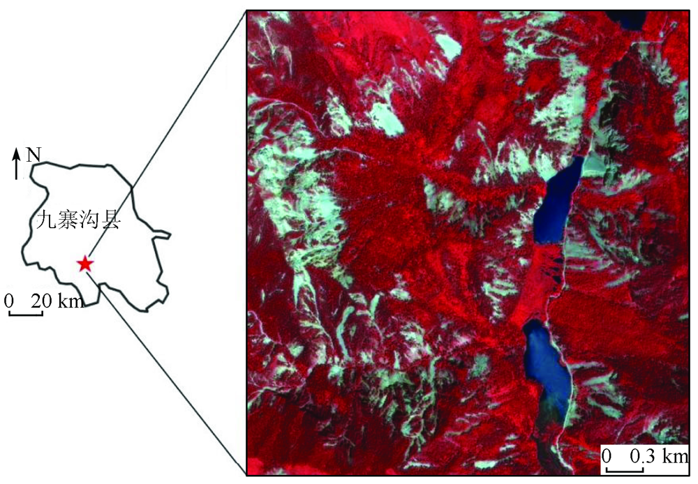
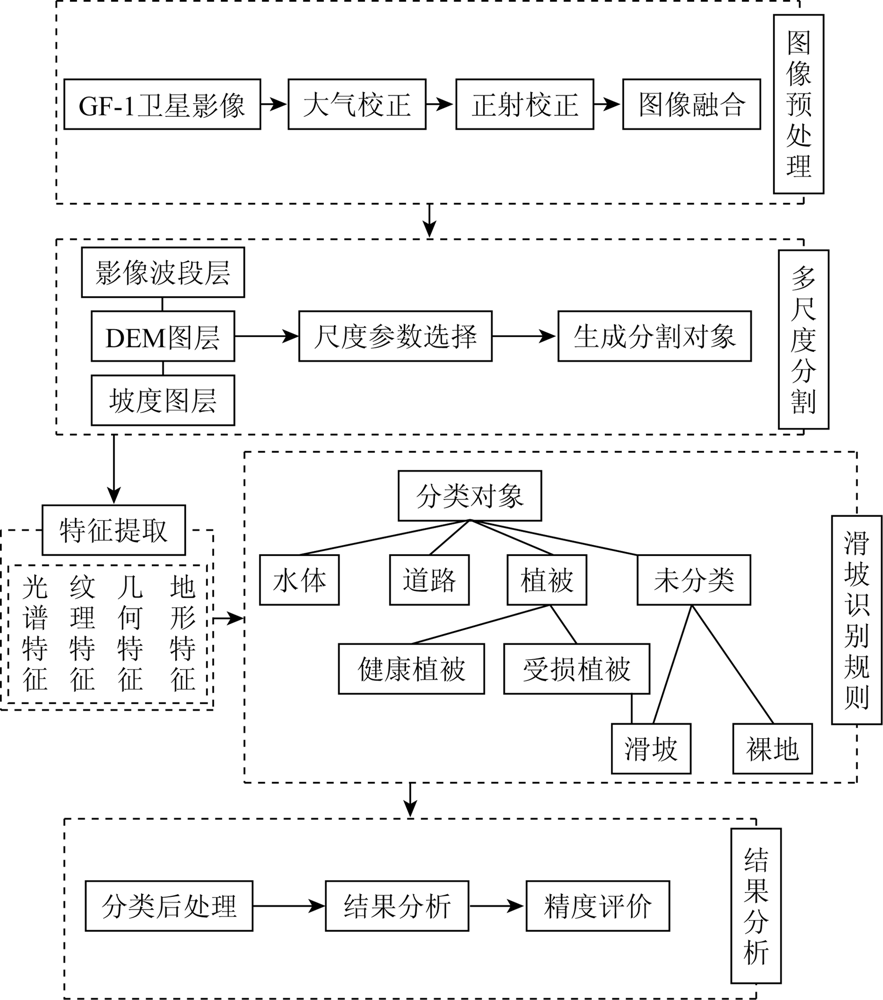
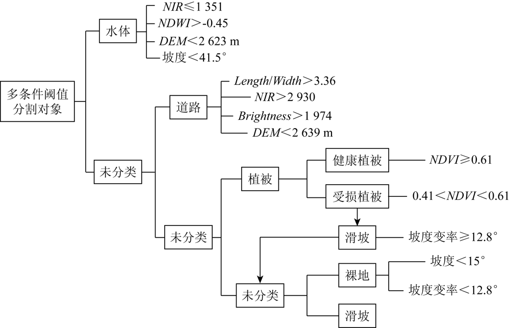
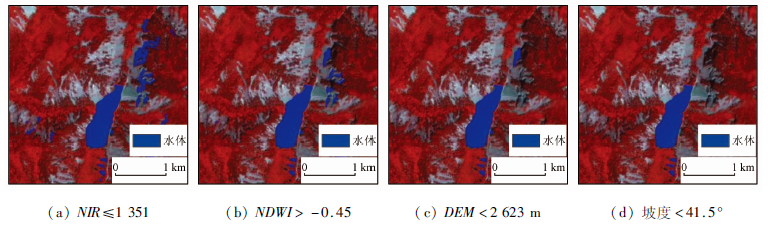
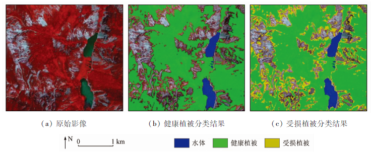
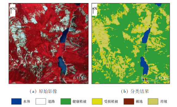
Earthquake-induced landslides are unnegligible secondary earthquake disasters and tend to cause severe casualties and property loss. Remote sensing identification of earthquake-induced landslides is an important means of the investigation and assessment of post-earthquake disasters. With GF-1 remote sensing images as a data source, this study identified the earthquake-induced landslides in the Xiongmaohai area in Jiuzhaigou using the object-oriented classification method. Specifically, the rule set for hierarchical identification of earthquake-induced landslides was constructed based on multi-scale segmentation and multi-conditional threshold classification. The aim is to fully utilize the features of ground objects, reduce the mixing of ground objects with similar spectra, and improve the identification precision of landslides. The identification results show that about 2.18 km2 of landslide area was extracted near the Xiongmaohai scenic spot, with a general identification accuracy of up to 98.11%. Therefore, the method proposed in this study can quickly identify earthquake-induced landslides, with high identification accuracy and applicable identification rules, and, thus, can be used as a reference and basis for the emergency investigation and rapid loss assessment of post-earthquake disasters.
Xu Q, Huang R Q. Kinetics charaterustics of large land-slides triggered by May 12th Wenchuan earthquake[J]. Journal of En-gineering Geology, 2008, 16(6):721-729.
Pei X J, Huang R Q. Analysis of characteristics of geological hazards by “4·20” Lushan earthquake in Sichuan,China[J]. Journal of Chengdu University of Technology(Science & Technology Edition), 2013, 40(3):257-263.
Cui P, Chen X Q, Zhang J Q, et al. Activities and tendency of mountain hazards induced by the Ms 7.0 Lushan earthquake,April 20,2013[J]. Journal of Mountain Science, 2013, 31(3):257-265.
Dong X J, Xu Q, She J X, et al. Preliminary study on interpretation of geological hazards in Jiuzhaigou based on multi-source remote sensing data[J]. Geomatics and Information Science of Wuhan University, 2020, 45(3):432-441.
Huang R Q, Pei X J, Li T B. Basic characteristics and formation mechanism of the largest scale landslide scale landslide at Daguangbao occurred during the Wenchuan earthquake[J]. Journal of Engineering Geology, 2008, 16(6):730-741.
[7]
殷跃平. 汶川八级地震滑坡特征分析[J]. 工程地质学报, 2009, 17(1):29-38.
Yin Y P. Features of landslides triggered by the Wenchuan earthquake[J]. Journal of Engineering Geology, 2009, 17(1):29-38.
Ge D Q. Comprehensive application of remote sensing in early identification,monitoring and early warning in geological disasters[J]. City and Disaster Reduction, 2008, 123(6):53-60.
Wu Y Q, Cao Z Q, Tao F X. Change detection of multi-temporal remote sensing images based on contourlet transform and ICA[J]. Journal of Geophysics, 2016, 59(4):1284-1292.
Hao L Z, Bai S B, Xu H B, et al. Landslide identification after earthquake based on CBERS-02 remote sensing data:The case of Qingchuan[J]. Journal of Institute of Disaster Prevention, 2010, 12(4):46-52.
Wu Y Q, Tao F X, Cao Z Q. Change detection of multi-temporal remote sensing images based on Shearlet transform and KPCA[J]. Journal of Basic Science and Engineering, 2014, 22(5):1030-1040.
Zhang Q, Zhao C Y. Semiautomatic object-oriented loose landslide recognition based on high resolution remote sensing images in Heifangtai,Gansu[J] .Journal of Catastrophology, 2017, 32(3):210-215.
[13]
Martha T R, Babu G K, Vinod K K. Damage and geological assessment of the 18 September 2011 Mw 6.9 earthquake in Sikkim,India using very high resolution satellite data[J]. Geoscience Frontiers,2015, 6(6):793-805.
doi: 10.1016/j.gsf.2013.12.011
[14]
Martha T R, Kamala P, Jose J, et al. Identification of new landslides from high resolution satellite data covering a large area using object-based change detection methods[J]. Research Article, 2016, 44(4):515-524.
[15]
Martha T R, Kerle N, Jetten V, et al. Characterising spectral spatial and morphometric properties of landslides for semiautomatic detection using object - oriented methods[J]. Geomorphology, 2010, 116(1):24-36.
doi: 10.1016/j.geomorph.2009.10.004
Yang W T, Wang M, Shi P J, et al. Object-oriented rapid identification of landslides based on terrain factors segmentation and classification[J]. Journal of Natural Disasters, 2015, 24(4):1-6.
Peng L, Xu S N, Mei J J, et al. Research on Wenchuan earthquake-induced landslides rapid recognition from ZY-3 imagery[J]. Remote Sensing Technology and Application, 2018, 33(1):185-192.
Peng L, Xu S N, Mei J J, et al. Earthquake-induced landslide recognition using high-resolution remote sensing images[J]. Journal of Remote Sensing, 2017, 21(4):509-518.
Yang L, Mou X L, Li C, et al. Risk assessment of geological hazards in Baota District,Yan’an City,Shaanxi,China[J]. Journal of Mountain Science, 2020, 38(5):679-690.
Wu R L, Dang X H, Zhou Z Y, et al. Fuzzy comprehensive evaluation of the vulnerability of geological disasters in Min County[J]. Geospatial Information, 2021, 19(3):86-89.
Dai L X, Xu Q, Fan X M, et al. A preliminary study on spatial distribution patterns of landslides triggered by Jiuzhaigou earthquake in Sichuan on August 8th,2017 and their susceptibility assessment[J]. Journal of Engineering Geology, 2017, 25(4):1151-1164.
 2023, Vol. 35
  ), 郝利娜1,2(