A method for extracting information on coastal aquacultural ponds from remote sensing images based on a U2-Net deep learning model
WANG Jianqiang1(), ZOU Zhaohui2(), LIU Rongbo3, LIU Zhisong2
1. Zhejiang Institute of Hydrogeology and Engineering Geology, Ningbo 315012, China 2. School of Information Engineering, Zhejiang Ocean University, Zhoushan 316022, China 3. Weifang Key Laboratory of Coastal Groundwater and Geological Environmental Protection and Restoration, Weifang 261021, China
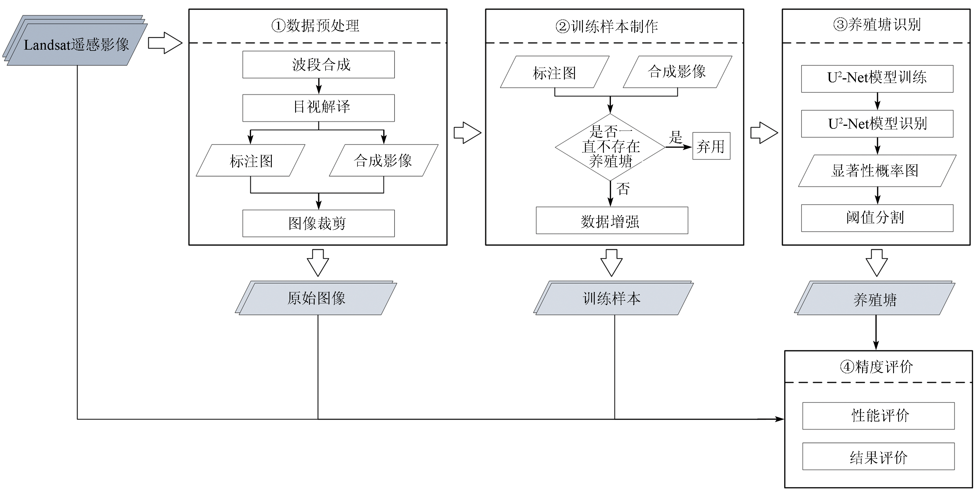
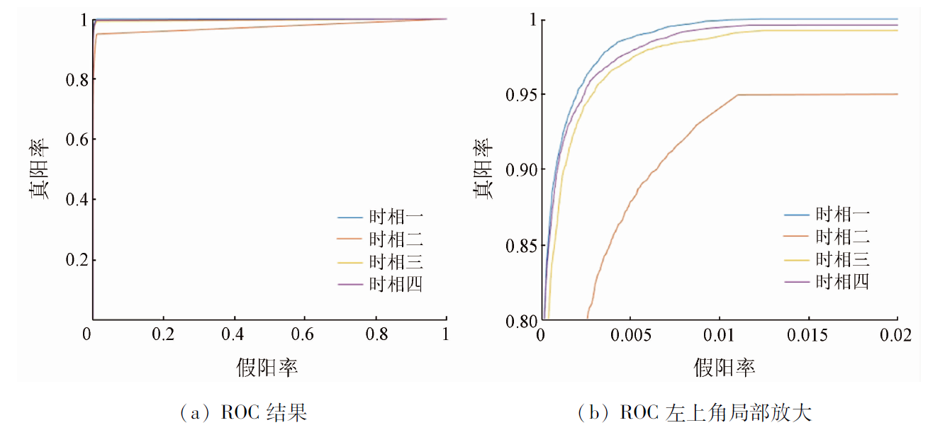
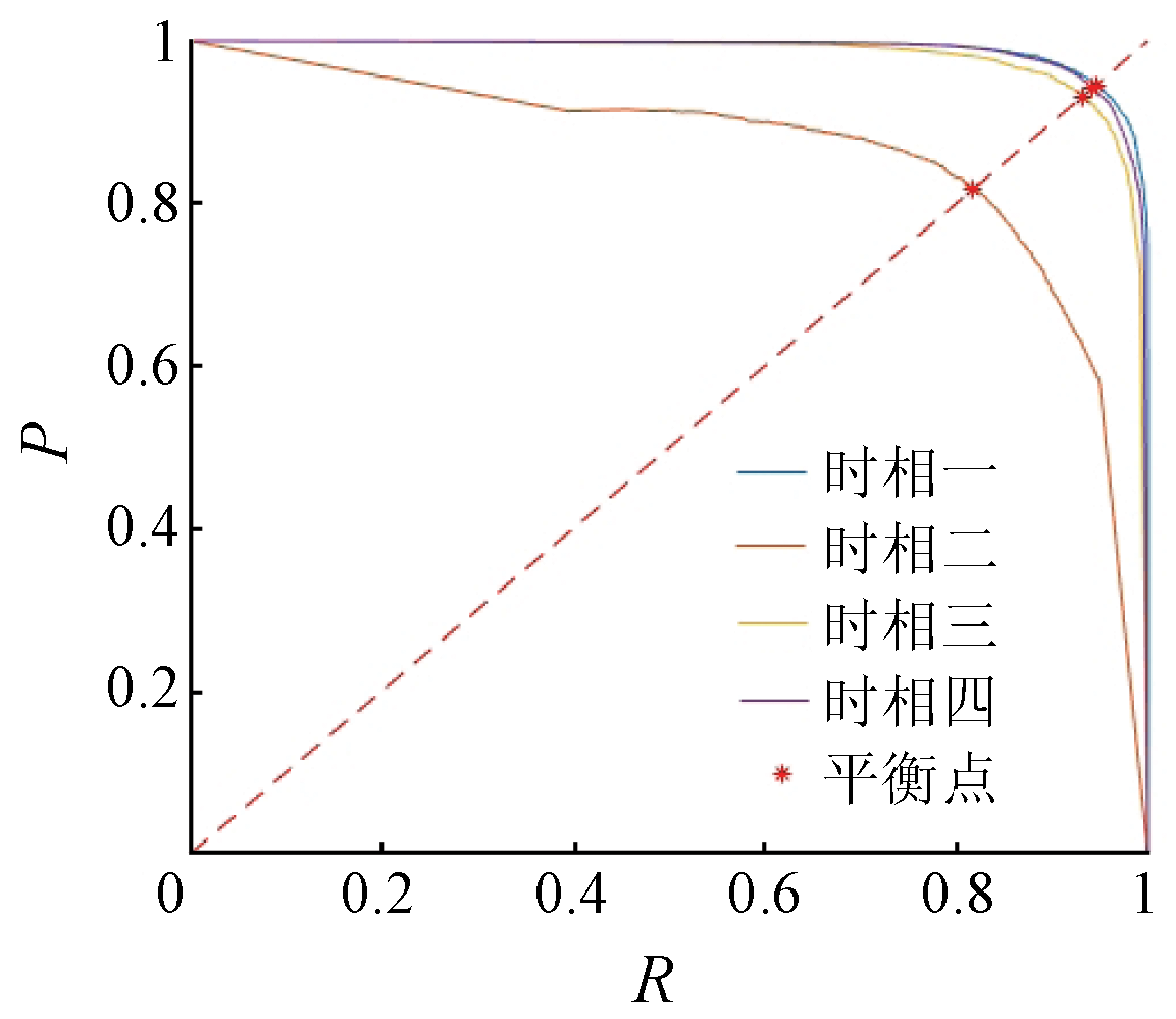
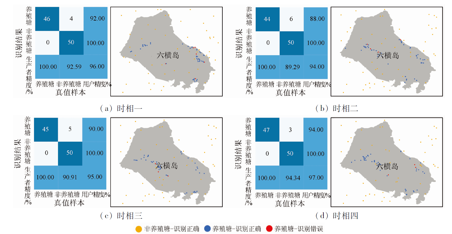
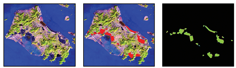
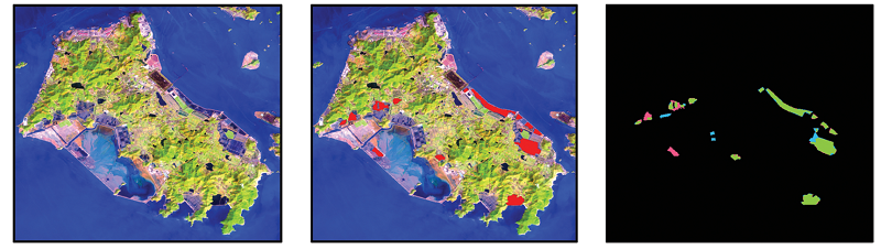
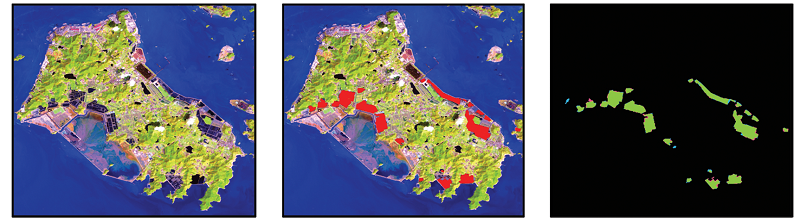
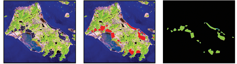
Conventional information extraction methods for aquacultural ponds frequently yield blurred boundaries and low accuracy due to the effect of different objects with the same spectrum in complex geographical environments of offshore and coastal areas. This study proposed a method for extracting information on coastal aquacultural ponds from remote sensing images based on the U2-Net deep learning model. First, an appropriate band combination method was selected to distinguish aquacultural ponds from other surface features through preprocessing of remote sensing images. Samples were then prepared through visual interpretation. Subsequently, the U2-Net model was trained, and information on coastal aquacultural ponds extracted. Finally, the scopes of aquacultural ponds were determined using the local optimum method. The experimental results show that the method proposed in this study yielded the average overall accuracy of 95.50%, with the average Kappa coefficient, recall, and F-value of 0.91, 91.45%, and 91.01%, respectively. Furthermore, 19 ponds were extracted, with a total area of 9.79 km2. The average accuracies of the number and area of aquacultural ponds were 94.06% and 93.18%, respectively. The method proposed in this study allows for quick and accurate mapping of coastal aquacultural ponds, thus providing technical support for marine resource management and sustainable development.
王建强, 邹朝晖, 刘荣波, 刘志松. 基于U2-Net深度学习模型的沿海水产养殖塘遥感信息提取[J]. 自然资源遥感, 2023, 35(3): 17-24.
WANG Jianqiang, ZOU Zhaohui, LIU Rongbo, LIU Zhisong. A method for extracting information on coastal aquacultural ponds from remote sensing images based on a U2-Net deep learning model. Remote Sensing for Natural Resources, 2023, 35(3): 17-24.
Food and Agriculture Organization of the United Nations. The state of world fisheries and aquaculture 2020. Sustainability in action[M]. Rome: Food and Agriculture Organization of the United Nations, 2020.
Dong J W, Wu W B, Huang J X, et al. State of the art and perspective of agricultural land use remote sensing information extraction[J]. Journal of Geo-Information Science, 2020, 22(4):772-783.
[4]
Marco O, Kersten C, Claudia K. Large-scale assessment of coastal aquaculture ponds with Sentinel-1 time series data[J]. Remote Sensing, 2017, 9(440):1-23.
Shu M, Du S H. Forty years’ progress andchallenges of remote sensing in national land survey[J]. Journal of Geo-Information Science, 2022, 24(4):597-616.
[6]
Mcfeeters S K. The use of the normalized difference water index (NDWI) in the delineation of open water features[J]. International Journal of Remote Sensing, 1996, 17(7):1425-1432.
doi: 10.1080/01431169608948714
Xu H Q. A study on information extraction of water body with the modified normalized difference water index (MNDWI)[J]. Journal of Remote Sensing, 2005, 9(5):589-595.
Ge Y F, Xia D, Tang H M, et al. Intelligent identification and extraction of geometric properties of rock discontinuities based on terrestrial laser scanning[J]. Chinese Journal of Rock Mechanics and Engineering, 2017, 36(12):3050-3061.
Ma Y, Jiang Q G, Meng Z G, et al. Classification of land use in farming area based on random forest algorithm[J]. Transactions of the Chinese Society for Agricultural Machinery, 2016, 47(1):297-303.
Dai J J, Wu Y N, Wang D H, et al. Object-oriented classification for the extraction of remote sensing information in rare earth mining areas[J]. Acta Geoscientica Sinica, 2018, 39(1):111-118.
Dai X L, Liu S F, Gong D Q. Text similarity detection method based on NLP[J]. Journal on Communications, 2021, 42(10):173-181.
doi: 10.11959/j.issn.1000-436x.2021192
Feng L F, Chen Y, Zhou T H, et al. Review of human lung and lung lesion regions segmentation methods based on CT images[J]. Journal of Image and Graphics, 2022, 27(3):722-749.
Zheng Z T, Fan H S, Wang J, et al. An improved double-branch network method for intelligently extracting marine cage culture area[J]. Remote Sensing for Land and Resources, 2020, 32(4):120-129.doi:10.6046/gtzyyg.2020.04.17.
doi: 10.6046/gtzyyg.2020.04.17
Wu Y T, Chen F, Ma Y, et al. Research on automatic extraction method for coastal aquaculture area using Landsat8 data[J]. Remote Sensing for Land and Resources, 2018, 30(3):96-105.doi:10.6046/gtzyyg.2018.03.14.
doi: 10.6046/gtzyyg.2018.03.14
Liu Y M, Yang X M, Wang Z H, et al. Extracting raft aquaculture areas in Sanduao from high-resolution remote sensing images using RCF[J]. Haiyang Xuebao, 2019, 41(4):119-130.
Gou J S, Jiang Y, Li Z N, et al. Aquaculture water body information extraction in the Chengdu plain based on Deeplabv3+ model[J]. Journal of Chinese Agricultural Mechanization, 2021, 42(3):105-112.
Wen K, Yao H M, Huang Y, et al. Remote sensing image extraction for coastal aquaculture ponds in the Guangxi Beibu Gulf based on Google Earth Engine[J]. Transactions of the Chinese Society of Agricultural Engineering, 2021, 37(12):280-288.
Liu C B, Xu J, Wang D M, et al. Extracting aquaculture pond using multi-feature optimization of GF-3 PolSAR imagery[J]. Transactions of the Chinese Society of Agricultural Engineering, 2022, 38(4):206-214.
Li L W, Zhang Y Y, Yue Z Y, et al. Extracting inland cage aquacultural areas from high-resolution remote sensing images using full convolutional networks model[J]. Shandong Science, 2022, 35(2):1-10.
[22]
Mei H, Ji G P, Wei Z, et al. Camouflaged object segmentation with distraction mining[C]// Proceedings of the IEEE/CVF Conference on Computer Vision and Pattern Recognition, 2021:8772-8781.
[23]
Han J, Ding J, Xue N, et al. Redet:A rotation-equivariant detector for aerial object detection[C]// Proceedings of the IEEE/CVF Conference on Computer Vision and Pattern Recognition, 2021:2786-2795.
[24]
Fang Z, Ren J, Sun H, et al. SAFDet:A semi-anchor-free detector for effective detection of oriented objects in aerial images[J]. Remote Sensing, 2020, 12(19):3225.
doi: 10.3390/rs12193225
[25]
Zeng Z, Wang D, Tan W, et al. RCSANet:A full convolutional network for extracting inland aquaculture ponds from high-spatial-resolution images[J]. Remote Sensing, 2020(1):92.
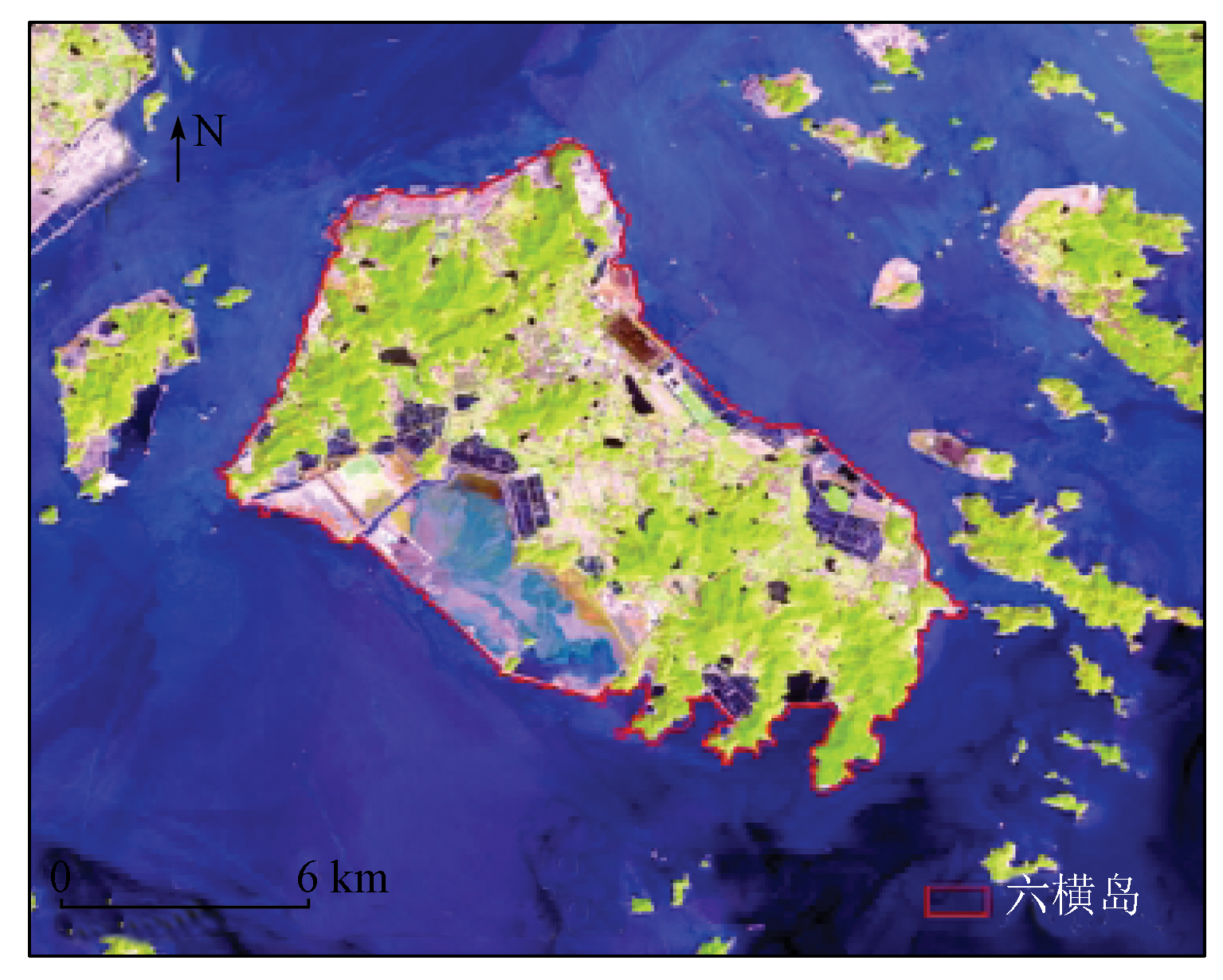
Chen C, Chen H X, Chen D, et al. Coastline extraction and spatial-temporal variations using remote sensing technology in Zhoushan Islands[J]. Remote Sensing for Land and Resource, 2021, 33(2):141-152.doi:10.6046/gtzyyg.2020248.
doi: 10.6046/gtzyyg.2020248
[27]
Wang L, Chen C, Xie F, et al. Estimation of the value of regional ecosystem services of an arvhipelago using satellite remote sensing technology:A case study of Zhoushan Archipelago,China[J]. International Journal of Applied Earth Observation and Geoinformation, 2021(105):102616.
Zhang P, Wang D, Lu H, et al. Learning uncertain convolutional features for accurate saliency detection[C]// Proceedings of the IEEE International Conference on Computer Vision, 2017:212-221.
[30]
Deng Z, Hu X, Zhu L, et al. R3net:Recurrent residual refinement network for saliency detection[C]// Proceedings of the 27th International Joint Conference on Artificial Intelligence.Menlo Park,CA,USA: AAAI Press, 2018:684-690.
[31]
Chen S, Tan X, Wang B, et al. Reverse attention for salient object detection[C]// Proceedings of the European Conference on Computer Vision (ECCV), 2018:234-250.
[32]
Zhang J, Liang Q W, Guo Q Q, et al. R2Net:Residual refinement network for salient object detection[J]. Image and Vision Computing, 2022(120):104423.
[33]
Zeng Y, Zhuge Y, Lu H, et al. Multi-source weak supervision for saliency detection[C]// Proceedings of the IEEE/CVF Conference on Computer Vision and Pattern Recognition, 2019:6074-6083.
[34]
Ronneberger O, Fischer P, Brox T. U-Net:Convolutional networks for biomedical image segmentation[C]// International Conference on Medical Image Computing and Computer-Assisted Intervention.Springer,Cham, 2015:234-241.
[35]
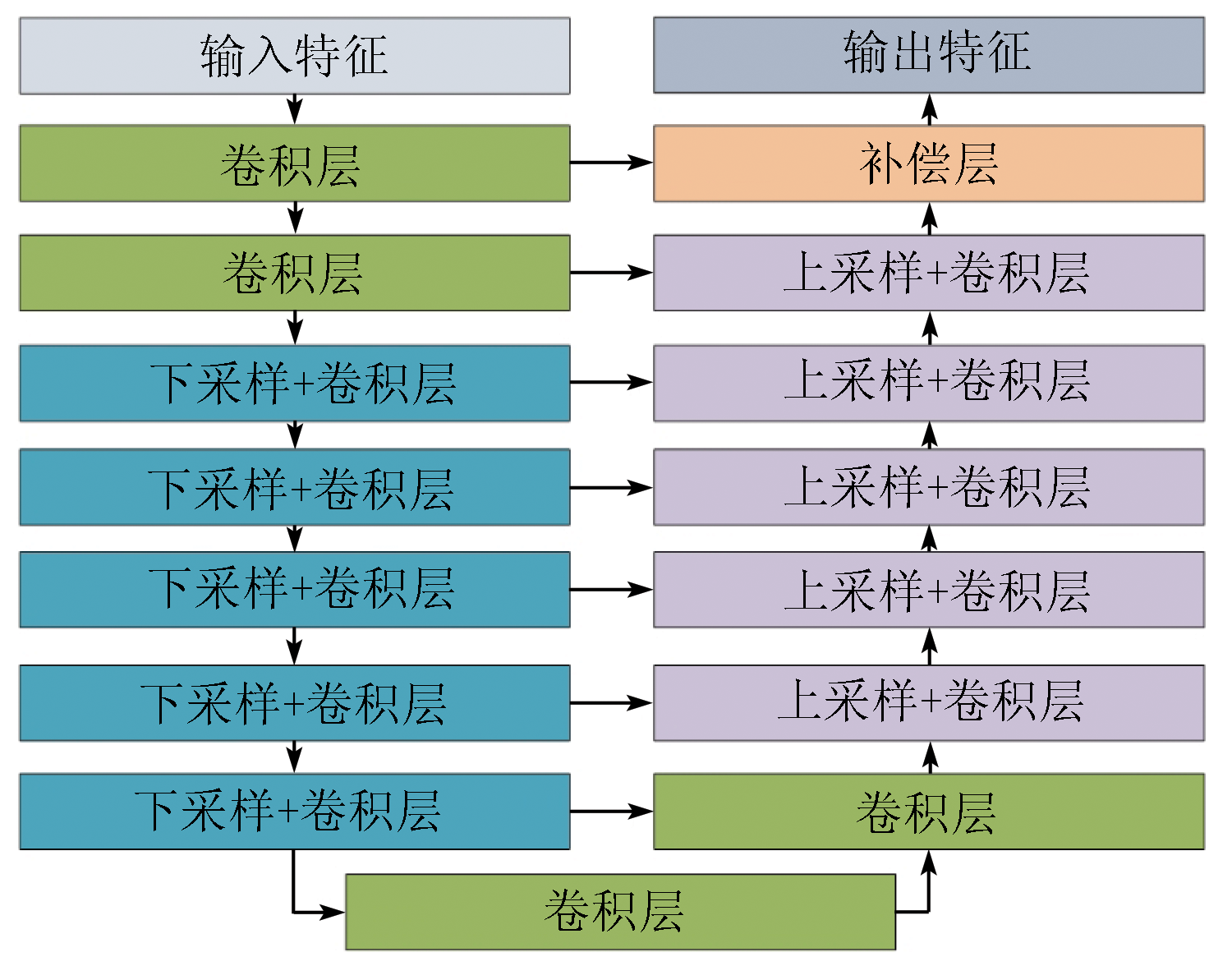
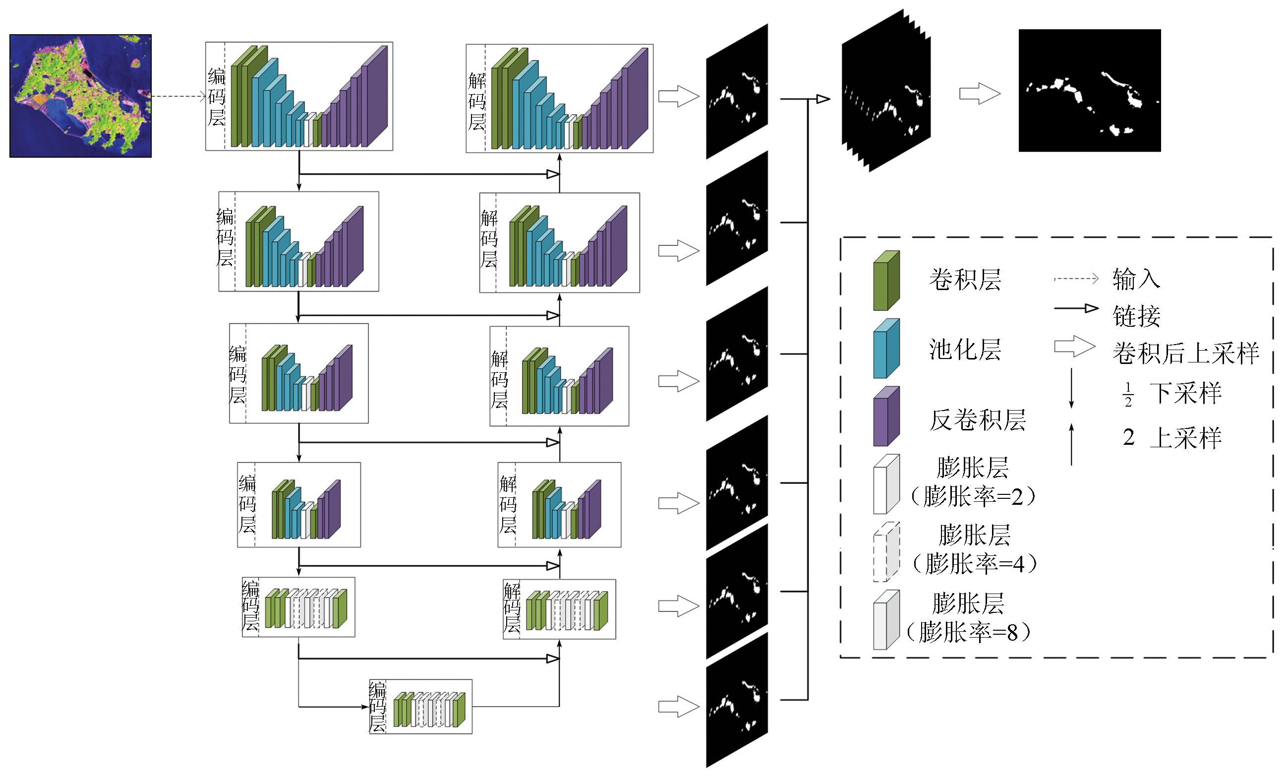
Qin X, Zhang Z, Huang C, et al. U2-Net:Going deeper with nested U-structure for salient object detection[J]. Pattern Recognition, 2020(106):107404.
 2023, Vol. 35
  ), 邹朝晖2(