A review of water body extraction from remote sensing images based on deep learning
WEN Quan1(), LI Lu2, XIONG Li3(), DU Lei4, LIU Qingjie5, WEN Qi6
1. Tencent Technology (Beijing) Co., Ltd., Beijing 100094, China 2. Zhejiang Lab, Hangzhou 311121, China 3. Jiangxi Disaster Reduction and Preparedness Center, Nanchang 330030, China 4. Land Satellite Remote Sensing Application Center, Ministry of Natural Resources, Beijing 100048, China 5. Hangzhou Innovation Institute of Beihang University, Hangzhou 310051, China 6. Technology and Engineering Center for Space Utilization, Chinese Academy of Sciences, Beijing 100094, China
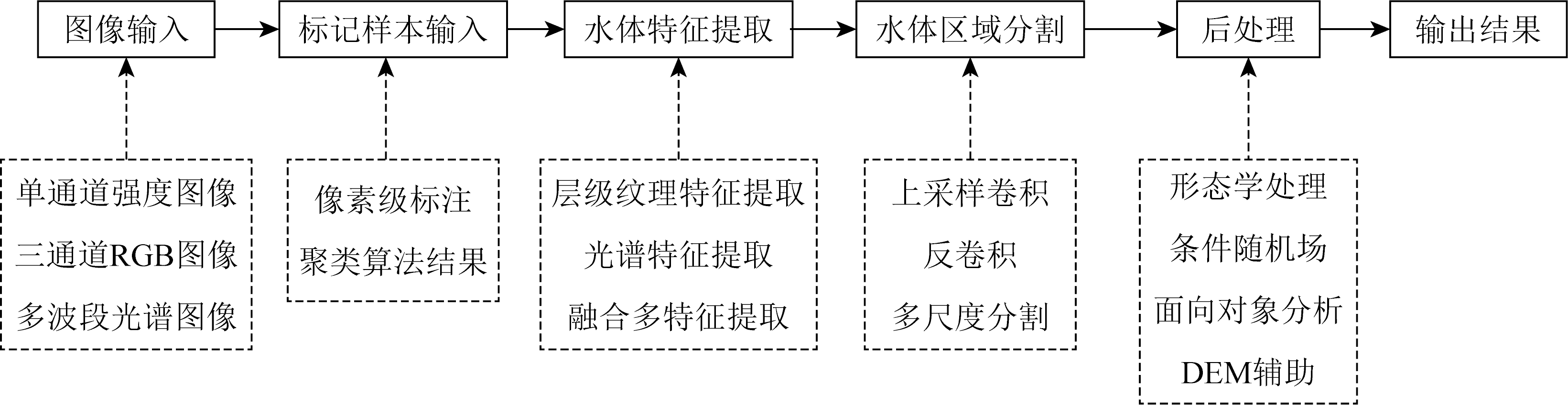
Timely and accurate detection and statistical analysis of the spatial distributions and time-series variations of water bodies like rivers and lakes holds critical significance and application value. It has become a significant interest in current remote sensing surface observation research. Conventional water body extraction methods rely on empirically designed index models for threshold-based segmentation or classification of water bodies. They are susceptible to shadows of surface features like vegetation and buildings, and physicochemical characteristics like sediment content and saline-alkali concentration in water bodies, thus failing to maintain robustness under different spatio-temporal scales. With the rapid acquisition of massive multi-source and multi-resolution remote sensing images, deep learning algorithms have gradually exhibited prominent advantages in water body extraction, garnering considerable attention both domestically and internationally. Thanks to the powerful learning abilities and flexible convolutional structure design schemes of deep neural network models, researchers have successively proposed various models and learning strategies to enhance the robustness and accuracy of water body extraction. However, there lacks a comprehensive review and problem analysis of research advances in this regard. Therefore, this study summarized the relevant research results published domestically and internationally in recent years, especially the advantages, limitations, and existing problems of different algorithms in the water body extraction from remote sensing images. Moreover, this study proposed suggestions and prospects for the advancement of deep learning-based methods for extracting water bodies from remote sensing images.
温泉, 李璐, 熊立, 杜磊, 刘庆杰, 温奇. 基于深度学习的遥感图像水体提取综述[J]. 自然资源遥感, 2024, 36(3): 57-71.
WEN Quan, LI Lu, XIONG Li, DU Lei, LIU Qingjie, WEN Qi. A review of water body extraction from remote sensing images based on deep learning. Remote Sensing for Natural Resources, 2024, 36(3): 57-71.
Fan Y D, Wen Q, Wang W, et al. Quantifying disaster physical damage using remote sensing data:A technical work flow and case study of the 2014 Ludian earthquake in China[J]. International Journal of Disaster Risk Science, 2017, 8(4):471-488.
Wang Z H, Li G, Jiang X. Flooded area detection method based on fusion of optical and SAR remote sensing images[J]. Journal of Radars, 2020, 9(3):539-553.
Li D, Wu B S, Chen B W, et al. Review of water body information extraction based on satellite remote sensing[J]. Journal of Tsinghua University(Science and Technology), 2020, 60(2):147-161.
Su L F, Li Z X, Gao F, et al. A review of remote sensing image water extraction[J]. Remote Sensing for Land and Resources, 2021, 33(1):9-19.doi:10.6046/gtzyyg.2020170.
Tan Q L, Liu Z J, Hu J P, et al. Measuring lake water level using multi-source remote sensing images combined with hydrological statistical data[J]. Journal of Beijing Jiaotong University, 2006, 30(4):26-30.
Sun D Y, Li Y M, Wang Q, et al. Simulation of spectral absorption characteristics of suspended sediment water[J]. Geography and Geo-Information Science, 2008, 24(5):16-20.
Zhang Y, Zhang D, Wang Y J, et al. Study of remote sensing-based bathymetric method in sand-containing water bodies[J]. Acta Oceanologica Sinica, 2008, 30(1):51-58.
Li H, Liu F, Yang S Y, et al. Remote sensing image fusion based on deep support value learning networks[J]. Chinese Journal of Computers, 2016, 39(8):1583-1596.
Xu J F, Zhang B M, Yu D H, et al. Aircraft target change detection for high-resolution remote sensing images using multi-feature fusion[J]. Journal of Remote Sensing, 2020, 24(1):37-52.
[10]
Li L, Wang C, Zhang H, et al. Urban building change detection in SAR images using combined differential image and residual U-Net network[J]. Remote Sensing, 2019, 11(9):1091.
[11]
Ruiz H D, Bacca C B, Caicedo B E. Data classification of hyperspectral images based on inception networks and extended attribute profiles[J]. International Journal of Remote Sensing, 2020, 41(22):8717-8738.
[12]
王航, 秦奋. 遥感影像水体提取研究综述[J]. 测绘科学, 2018, 43(5):23-32.
Wang H, Qin F. Summary of the research on water body extraction and application from remote sensing image[J]. Science of Surveying and Mapping, 2018, 43(5):23-32.
Yuan X Z, Jiang H, Chen Y Z, et al. Extraction of water body information using adaptive threshold value and OTSU algorithm[J]. Remote Sensing Information, 2016, 31(5):36-42.
Zeng L F, Li L, Wan L H. SAR based fast flood mapping using Sentinel-1 imagery[J]. Geomatics World, 2015, 22(5):100-103,107.
[15]
Cao H, Zhang H, Wang C, et al. Operational flood detection using Sentinel-1 SAR data over large areas[J]. Water, 2019, 11(4):786.
[16]
Klemenjak S, Waske B, Valero S, et al. Automatic detection of ri-vers in high-resolution SAR data[J]. IEEE Journal of Selected Topics in Applied Earth Observations and Remote Sensing, 2012, 5(5):1364-1372.
[17]
Martinis S, Twele A, Voigt S. Unsupervised extraction of flood-induced backscatter changes in SAR data using Markov image modeling on irregular graphs[J]. IEEE Transactions on Geoscience and Remote Sensing, 2011, 49(1):251-263.
[18]
McFeeters S K. The use of the normalized difference water index (NDWI) in the delineation of open water features[J]. International Journal of Remote Sensing, 1996, 17(7):1425-1432.
Du J K, Huang Y S, Feng X Z, et al. Study on water bodies extraction and classification from SPOT image[J]. Journal of Remote Sensing, 2001, 5(3):214-219.
Xu H Q. A study on information extraction of water body with the modified normalized difference water index(MNDWI)[J]. Journal of Remote Sensing, 2005, 9(5):589-595.
Luo J C, Sheng Y W, Shen Z F, et al. Automatic and high-precise extraction for water information from multispectral images with the step-by-step iterative transformation mechanism[J]. Journal of Remote Sensing, 2009, 13(4):610-615.
Shen Z F, Xia L G, Li J L, et al. Automatic and high-precision extraction of rivers from remotely sensed images with Gaussian normalized water index[J]. Journal of Image and Graphics, 2013, 18(4):421-428.
[23]
Yamazaki D, Trigg M A, Ikeshima D. Development of a global -90 m water body map using multi-temporal Landsat images[J]. Remote Sensing of Environment, 2015, 171:337-351.
[24]
Guo Q D, Pu R L, Li J L, et al. A weighted normalized difference water index for water extraction using Landsat imagery[J]. International Journal of Remote Sensing, 2017, 38(19):5430-5445.
[25]
Zhou Y, Zhao H R, Hao H, et al. A new multi-spectral threshold normalized difference water index (MST-NDWI) water extraction method:A case study in Yanhe watershed[J]. The International Archives of the Photogrammetry,Remote Sensing and Spatial Information Sciences,2018,XLII-3:2557-2564.
[26]
Yao F F, Wang J D, Wang C, et al. Constructing long-term high-frequency time series of global lake and reservoir areas using Landsat imagery[J]. Remote Sensing of Environment, 2019, 232:111210.
[27]
Ahmad S K, Hossain F, Eldardiry H, et al. A fusion approach for water area classification using visible,near infrared and synthetic aperture Radar for South Asian conditions[J]. IEEE Transactions on Geoscience and Remote Sensing, 2020, 58(4):2471-2480.
[28]
Feyisa G L, Meilby H, Fensholt R, et al. Automated water extraction index:A new technique for surface water mapping using Landsat imagery[J]. Remote Sensing of Environment, 2014, 140:23-35.
[29]
Yang X C, Qin Q M, Grussenmeyer P, et al. Urban surface water body detection with suppressed built-up noise based on water indices from Sentinel-2 MSI imagery[J]. Remote Sensing of Environment, 2018, 219:259-270.
Guo J C, Li P J, Xiao X B. A hierarchical segmentation method for multispectral imagery[J]. Acta Scientiarum Naturalium Universitatis Pekinensis, 2009, 45(2):306-310.
[31]
Tehrany M S, Pradhan B, Jebur M N. Remote sensing data reveals eco-environmental changes in urban areas of Klang Valley,Malaysia:Contribution from object based analysis[J]. Indian Society of Remote Sensing, 2013, 41(4):981-991.
Zhang M, Zeng Y N, Zhu Y S. Wetland mapping of Donting Lake basin based on time-series MODIS data and object-oriented method[J]. Journal of Remote Sensing, 2017, 21(3):479-492.
[33]
Deng Y, Zhang H, Wang C, et al. Object-oriented water extraction of PolSAR image based on target decomposition[C]// 2015 IEEE 5th Asia-Pacific Conference on Synthetic Aperture Radar(APSAR),IEEE, 2015: 596-601.
Deng Y, Zhang H, Wang C, et al. An object-oriented water extraction method based on texture and polarimetric decomposition feature[J]. Remote Sensing Technology and Application, 2016, 31(4):714-723.
Wu R J, He X F. Coastal wetland change detection using fusion of high resolution Radar and optical images[J]. Science of Surveying and Mapping, 2020, 45(11):93-100.
Lin S H. Study on water information extraction method of GF-1 image based on the combination of NDWI and modified FCM[J]. Geomatics and Spatial Information Technology, 2017, 40(6):86-88.
Hong L, Huang Y J, Yang K, et al. Study on urban surface water extraction from heterogeneous environments using GF-2 remotely sensed images[J]. Journal of Remote Sensing, 2019, 23(5):871-882.
Duan Q Y, Meng L K, Fan Z W, et al. Applicability of the water information extraction method based on GF-1 image[J]. Remote Sensing for Land and Resources, 2015, 27(4):79-84.doi:10.6046/gtzyyg.2015.04.13.
Shen L, Tang H, Wang S D, et al. River extraction from the high resolution remote sensing image based on spatially correlated pixels template and Adaboost algorithm[J]. Acta Geodaetica et Cartographica Sinica, 2013, 42(3):344-350.
Song Y Q, Yang L A, Xu J T, et al. Water body information extraction based on Landsat-8 satellite OLI remote sensing image and AdaBoost algorithm[J]. Journal of Geomatics, 2017, 42(3):44-47.
Wang Q F, Zhang M R, Zhang Y, et al. Intelligent extraction of remote sensing information on large-scale water based on visual attention mechanism[J]. Journal of Computer Applications, 2020, 40(4):1038-1044.
doi: 10.11772/j.issn.1001-9081.2019081492
Hu D Y, Li J, Chen Y H, et al. Water and settlement area extraction from single-band,single-polarization SAR images based on SVM method[J]. Journal of Image and Graphics, 2008, 13(2):257-263.
[43]
Pradhan B, Hagemann U, Shafapour Tehrany M, et al. An easy to use ArcMap based texture analysis program for extraction of flooded areas from TerraSAR-X satellite image[J]. Computers and Geosciences, 2014, 63:34-43.
[44]
Goodfellow I J, Pouget-Abadie J, Mirza M, et al. Generative adversarial networks[J/OL]. arXiv, 2014(2014-06-10). https://arxiv.org/abs/1406.2661v1.
[45]
Simonyan K, Zisserman A. Very deep convolutional networks for large-scale image recognition[J/OL]. arxiv, 2014(2014-09-04). https://arxiv.org/abs/1409.1556.
[46]
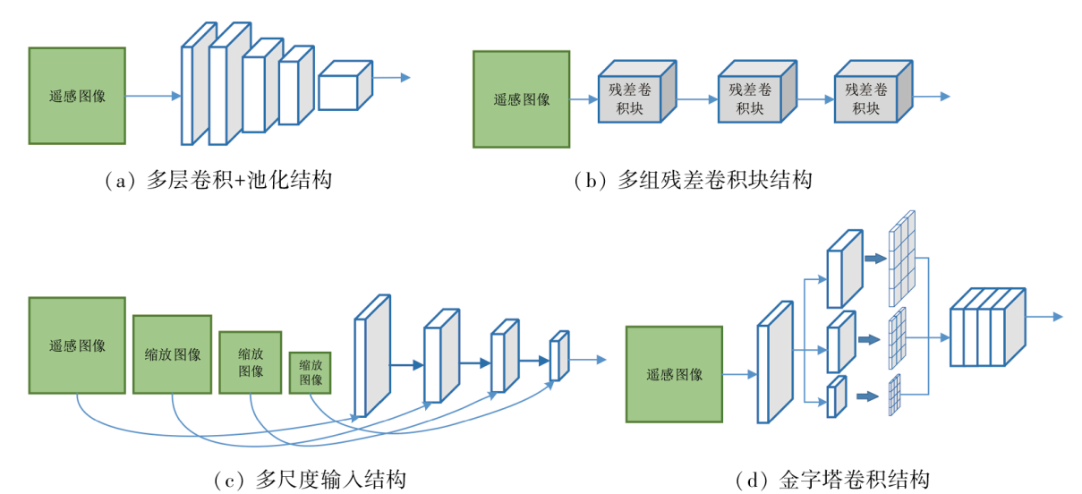
He K M, Zhang X, Ren S, et al. Deep residual learning for image recognition[C]// 2016 IEEE Conference on Computer Vision and Pattern Recognition CVPR.IEEE. 2016:770-778.
[47]
Tan M X, Le Q V. EfficientNet:Rethinking model scaling for convolutional neural networks[J/OL]. arXiv, 2019(2019-05-28). http://arxiv.org/abs/1905.11946v5.
[48]
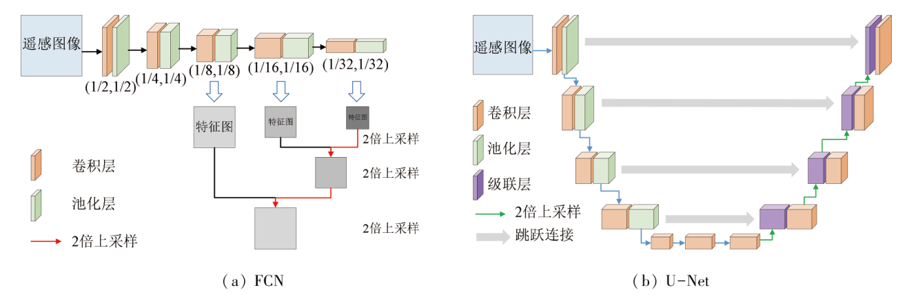
Shelhamer E, Long J, Darrell T. Fully convolutional networks for semantic segmentation[J]. IEEE Transactions on Pattern Analysis and Machine Intelligence, 2017, 39(4):640-651.
doi: 10.1109/TPAMI.2016.2572683
pmid: 27244717
[49]
Ronneberger O, Fischer P, Brox T. U-net:Convolutional networks for biomedical image segmentation[C]// International Conference on Medical Image Computing and Computer-Assisted Intervention.Cham:Springer, 2015:234-241.
[50]
Chen L C, Papandreou G, Kokkinos I, et al. Semantic image segmentation with deep convolutional nets and fully connected CRFs[J/OL]. arXiv, 2014(2014-12-22). https://arxiv.org/abs/1412.7062v4.
[51]
Chen L C, Papandreou G, Schroff F, et al. Rethinking atrous convolution for semantic image segmentation[J/OL]. arXiv, 2017(2017-06-17). https://arxiv.org/abs/1706.05587.
[52]
Gong M G, Yang H L, Zhang P Z. Feature learning and change feature classification based on deep learning for ternary change detection in SAR images[J]. ISPRS Journal of Photogrammetry and Remote Sensing, 2017, 129:212-225.
Li X W, Li Y S, Zhang Y J. Weakly supervised deep semantic segmentation network for water body extraction based on multi-source remote sensing imagery[J]. Journal of Image and Graphics, 2021, 26(12):3015-3026.
Wang Z Y, Yu L, Tian S W, et al. Water body extraction method based on stacked autoencoder[J]. Journal of Computer Applications, 2015, 35(9):2706-2709.
doi: 10.11772/j.issn.1001-9081.2015.09.2706
[55]
Guo Y H, Wang S, Gao C Q, et al. Wishart RBM based DBN for polarimetric synthetic Radar data classification[C]// 2015 IEEE International Geoscience and Remote Sensing Symposium,(IGARSS).IEEE, 2015: 1841-1844.
[56]
Liu F, Jiao L C, Hou B, et al. Pol-SAR image classification based on wishart DBN and local spatial information[J]. IEEE Transactions on Geoscience and Remote Sensing, 2016, 54(6):3292-3308.
He H Q, Du J, Chen T, et al. Remote sensing image water body extraction combing NDWI with convolutional neural network[J]. Remote Sensing Information, 2017, 32(5):82-86.
Liang Z Y. Research on water information extraction method of multi-source remote sensing based on deep learning and its application[D]. Hefei: Anhui University, 2019.
Lyu Y L, Tian S W, Yu L, et al. CNN_SVM water body recognition based on spatial-spectral features[J]. Computer Engineering and Design, 2019, 40(5):1435-1439.
[61]
Wang Y D, Li Z W, Zeng C, et al. An urban water extraction method combining deep learning and Google Earth Engine[J]. IEEE Journal of Selected Topics in Applied Earth Observations and Remote Sensing, 2020, 13:769-782.
[62]
Wang L, Wang H. Water hazard detection using conditional generative adversarial network with mixture reflection attention units[J]. IEEE Access, 2019, 7:167497-167506.
doi: 10.1109/ACCESS.2019.2953768
Wang H Y, Sun Z P, Sun Z W, et al. The application for extraction of river channels and change detection based on deep learning:A case study from Yongding River[J]. Beijing Surveying and Mapping, 2019, 33(2):173-178.
[64]
Weng L G, Xu Y M, Xia M, et al. Water areas segmentation from remote sensing images using a separable residual SegNet network[J]. ISPRS International Journal of Geo-Information, 2020, 9(4):256.
[65]
Zhang Z X, Liu Q J, Wang Y H. Road extraction by deep residual U-Net[J]. IEEE Geoscience and Remote Sensing Letters, 2018, 15(5):749-753.
Wu C Z, Chen X, Ji D, et al. Image denoising via residual network based on perceptual loss[J]. Journal of Image and Graphics, 2018, 23(10):1483-1491.
[67]
Qiu C P, Mou L C, Schmitt M, et al. Fusing multiseasonal Sentinel-2 imagery for urban land cover classification with multibranch residual convolutional neural networks[J]. IEEE Geoscience and Remote Sensing Letters, 2020, 17(10):1787-1791.
[68]
Cai Y H, Guo Y J, Lang S N, et al. Classification of hyperspectral images by spectral-spatial dense-residual network[J]. Journal of Applied Remote Sensing, 2020, 14(3):036513.
[69]
Yu L, Zhang R N, Tian S W, et al. Deep multi-feature learning for water body extraction from Landsat imagery[J]. Automatic Control and Computer Sciences, 2018, 52(6):517-527.
Zhao H P. Research on water identification with hollow-spectrum features and deep learning based on big data[D]. Dalian: Dalian Jiaotong University, 2018.
[71]
Chen Y, Tang L L, Kan Z H, et al. A novel water body extraction neural network (WBE-NN) for optical high resolution multispectral imagery[J]. Journal of Hydrology, 2020, 588:125092.
[72]
Miao Z M, Fu K, Sun H, et al. Automatic water body segmentation from high-resolution satellite images via deep networks[J]. IEEE Geoscience and Remote Sensing Letters, 2018, 15(4):602-606.
[73]
Talal M, Panthakkan A, Mukhtar H, et al. Detection of water bodies using semantic segmentation[C]// 2018 International Conference on Signal Processing and Information Security(ICSPIS).IEEE, 2018: 1-4.
Yang Z, Ou W H, Liu X Y, et al. Water information extraction for high resolution remote sensing image based on LinkNet convolutional neural network[J]. Journal of Yunnan University(Natural Sciences Edition), 2019, 41(5):932-938.
[75]
Yan R D, Dong S. Optical remote sensing image waters extraction technology based on deep learning context-Unet[C]// 2019 IEEE International Conference on Signal,Information and Data Processing(ICSIDP).IEEE, 2019: 1-4.
[76]
Nemni E, Bullock J, Belabbes S, et al. Fully convolutional neural network for rapid flood segmentation in synthetic aperture Radar imagery[J]. Remote Sensing, 2020, 12(16):2532.
Wang X, Sui L C, Zhong M Q, et al. Fully convolution neural networks for water extraction of remote sensing images[J]. Bulletin of Surveying and Mapping, 2018(6):41-45.
doi: 10.13474/j.cnki.11-2246.2018.0173
[78]
Kim S M, Shin J, Baek S, et al. U-Net convolutional neural network model for deep red tide learning using GOCI[J]. Journal of Coastal Research, 2019, 90(s1):302.
Wang N, Cheng J H, Zhang H Y, et al. Application of U-net model to water extraction with high resolution remote sensing data[J]. Remote Sensing for Land and Resources, 2020, 32(1):35-42.doi:10.6046/gtzyyg.2020.01.06.
[80]
Ge C J, Xie W J, Meng L K. Extracting lakes and reservoirs from GF-1 satellite imagery over China using improved U-Net[J]. IEEE Geoscience and Remote Sensing Letters, 2022, 19:1504105.
[81]
Li Z Y, Wang R, Zhang W, et al. Multiscale features supported DeepLab V3+ optimization scheme for accurate water semantic segmentation[J]. IEEE Access, 2019, 7:155787-155804.
[82]
Duan L H, Hu X Y. Multiscale refinement network for water body segmentation in high-resolution satellite imagery[J]. IEEE Geoscience and Remote Sensing Letters, 2020, 17(4):686-690.
[83]
Feng W Q, Sui H G, Huang W M, et al. Water body extraction from very high-resolution remote sensing imagery using deep U-Net and a superpixel-based conditional random field model[J]. IEEE Geoscience and Remote Sensing Letters, 2019, 16(4):618-622.
[84]
Chen Y, Fan R S, Yang X C, et al. Extraction of urban water bodies from high-resolution remote-sensing imagery using deep learning[J]. Water, 2018, 10(5):585.
Shen J A, Ma M T, Song Z Y, et al. Water information extraction from high-resolution remote sensing images using the deep-learning based semantic segmentation model[J]. Remote Sensing for Natural Resources, 2022, 34(4):129-135.doi:10.6046/zrzyyg.2021357.
[86]
Wieland M, Martinis S, Kiefl R, et al. Semantic segmentation of water bodies in very high-resolution satellite and aerial images[J]. Remote Sensing of Environment, 2023, 287:113452.
[87]
Parajuli J, Fernandez-Beltran R, Kang J, et al. Attentional dense convolutional neural network for water body extraction from Sentinel-2 images[J]. IEEE Journal of Selected Topics in Applied Earth Observations and Remote Sensing, 2022, 15:6804-6816.
[88]
Lu M, Fang L, Li M, et al. NFANet:A novel method for weakly supervised water extraction from high-resolution remote-sensing imagery[J]. IEEE Transactions on Geoscience and Remote Sensing, 2022, 60:5617114.
[89]
Xiang D Q, Zhang X, Wu W, et al. DensePPMUNet:A robust deep learning network for segmenting water bodies from aerial images[J]. IEEE Transactions on Geoscience and Remote Sensing, 2023, 61:4202611.
[90]
Zhang P P, Wang G J. The modified encoder-decoder network based on depthwise separable convolution for water segmentation of real SAR imagery[C]// International Applied Computational Electromagnetics Society Symposium-China(ACES).IEEE, 2019:1-2.
[91]
Zhang J S, Xing M D, Sun G C, et al. Water body detection in high-resolution SAR images with cascaded fully-convolutional network and variable focal loss[J]. IEEE Transactions on Geoscience and Remote Sensing, 2021, 59(1):316-332.
[92]
Zhang P, Chen L F, Li Z H, et al. Automatic extraction of water and shadow from SAR images based on a multi-resolution dense encoder and decoder network[J]. Sensors, 2019, 19(16):3576.
[93]
Avolio C, Tricomi A, Mammone C, et al. A deep learning architecture for heterogeneous and irregularly sampled remote sensing time series[C]// 2019 IEEE International Geoscience and Remote Sensing Symposium,Yokohama(IGARSS).IEEE, 2019:9807-9810.
[94]
Huang K, Nie W, Luo N X. Fully polarized SAR imagery classification based on deep reinforcement learning method using multiple polarimetric features[J]. IEEE Journal of Selected Topics in Applied Earth Observations and Remote Sensing, 2019, 12(10):3719-3730.
doi: 10.1109/JSTARS.2019.2913445
[95]
Ahishali M, Kiranyaz S, Ince T, et al. Multifrequency PolSAR image classification using dual-band 1D convolutional neural networks[C]// 2020 Mediterranean and Middle-East Geoscience and Remote Sensing Symposium (M2GARSS).IEEE, 2020:73-76.
[96]
Ni J, Zhang F, Yin Q, et al. Random neighbor pixel-block-based deep recurrent learning for polarimetric SAR image classification[J]. IEEE Transactions on Geoscience and Remote Sensing, 2021, 59(9):7557-7569.
[97]
Wang Y, He C, Liu X, et al. A hierarchical fully convolutional network integrated with sparse and low-rank subspace representations for PolSAR imagery classification[J]. Remote Sensing, 2018, 10(2):342.
[98]
Xue W B, Yang H, Wu Y L, et al. Water body automated extraction in polarization SAR images with dense-coordinate-feature-concatenate network[J]. IEEE Journal of Selected Topics in Applied Earth Observations and Remote Sensing, 2021, 14:12073-12087.
[99]
Hertel V, Chow C, Wani O, et al. Probabilistic SAR-based water segmentation with adapted Bayesian convolutional neural network[J]. Remote Sensing of Environment, 2023, 285:113388.
[100]
Zhang Z M, Wang H P, Xu F, et al. Complex-valued convolutional neural network and its application in polarimetric SAR image classification[J]. IEEE Transactions on Geoscience and Remote Sensing, 2017, 55(12):7177-7188.
[101]
Chen J K, Qiu X L. Equivalent complex valued deep semantic segmentation network for SAR images[C]// 2019 International Applied Computational Electromagnetics Society Symposium-China(ACES).IEEE, 2019:1-2.
[102]
Wilmanski M, Kreucher C, Hero A. Complex input convolutional neural networks for wide angle SAR ATR[C]// 2016 IEEE Global Conference on Signal and Information Processing (GlobalSIP).IEEE, 2016:1037-1041.
[103]
Sun Z B, Xu X H, Pan Z. SAR ATR using complex-valued CNN[C]// 2020 Asia-Pacific Conference on Image Processing,Electronics and Computers (IPEC).IEEE, 2020:125-128.
[104]
Mu H L, Zhang Y, Jiang Y C, et al. CV-GMTINet:GMTI using a deep complex-valued convolutional neural network for multichannel SAR-GMTI system[J]. IEEE Transactions on Geoscience and Remote Sensing, 2022, 60:5201115.
[105]
李胜. 联合领域知识和深度学习的城市地表覆盖变化检测方法[D]. 武汉: 武汉大学, 2018.
Li S. Detection method of urban land cover change based on combining domain knowledge and deep learning[D]. Wu Han: Wuhan University, 2018.
Zhang S Y. High resolution remote sensing image land cover classification based on deep learning and multi-scale and multi-feature fusion[D]. Hangzhou: Zhejiang University, 2020.
[107]
Sun H, Liu S, Zhou S, et al. Unsupervised cross-view semantic transfer for remote sensing image classification[J]. IEEE Geoscience and Remote Sensing Letters, 2016, 13(1):13-17.
[108]
Maggiori E, Tarabalka Y, Charpiat G, et al. Convolutional neural networks for large-scale remote-sensing image classification[J]. IEEE Transactions on Geoscience and Remote Sensing, 2017, 55(2):645-657.
[109]
Tong X Y, Xia G S, Lu Q K, et al. Learning transferable deep models for land-use classification with high-resolution remote sensing images[J/OL]. arXiv, 2018(2018-07-16). https://arxiv.org/abs/1807.05713v1.
[110]
Wan L, Liu N, Huo H, et al. Selective convolutional neural networks and cascade classifiers for remote sensing image classification[J]. Remote Sensing Letters, 2017, 8(10):917-926.
[111]
Wang G, Fan B, Xiang S, et al. Aggregating rich hierarchical features for scene classification in remote sensing imagery[J]. IEEE Journal of Selected Topics in Applied Earth Observations and Remote Sensing, 2017, 10(9):4104-4115.
[112]
Geng J, Ma X R, Zhou X J, et al. Saliency-guided deep neural networks for SAR image change detection[J]. IEEE Transaction on Geoscience and Remote Sensing, 2019, 57(10):7365-7377.
[113]
Song A, Kim Y, Kim Y. Change detection of surface water in remote sensing images based on fully convolutional network[J]. Journal of Coastal Research, 2019, 91(s1):426.
[114]
Li Y Y, Peng C, Chen Y Q, et al. A deep learning method for change detection in synthetic aperture Radar images[J]. IEEE Transactions on Geoscience and Remote Sensing, 2019, 57(8):5751-5763.
[115]
Su L Z, Cao X. Fuzzy autoencoder for multiple change detection in remote sensing images[J]. Journal of Applied Remote Sensing, 2018, 12(3): 035014.
[116]
Gao F, Wang X, Gao Y H, et al. Sea ice change detection in SAR images based on convolutional-wavelet neural networks[J]. IEEE Geoscience and Remote Sensing Letters, 2019, 16(8):1240-1244.
[117]
Chen H, Wu C, Du B, et al. Change detection in multisource VHR images via deep Siamese convolutional multiple-layers recurrent neural network[J]. IEEE Transactions on Geoscience and Remote Sensing, 2020, 58(4):2848-2864.
[118]
Lyu H, Lu H, Mou L C. Learning a transferable change rule from a recurrent neural network for land cover change detection[J]. Remote Sensing, 2016, 8(6):506.
[119]
Demir I, Koperski K, Lindenbaum D, et al. DeepGlobe 2018:A challenge to parse the earth through satellite images[C]// 2018 IEEE/CVF Conference on Computer Vision and Pattern Recognition Workshops (CVPRW).IEEE, 2018:172-181.
[120]
Zhang M, Hu X, Zhao L, et al. Learning dual multi-scale manifold ranking for semantic segmentation of high-resolution images[J]. Remote Sensing, 2017, 9(5):500.
[121]
Li Y, Chen L. Land cover classification for high resolution remote sensing images with atrous convolution and BFS[C]// 2019 IEEE 5th International Conference on Computer and Communications (ICCC).IEEE, 2019: 1808-1813.
[122]
Schmitt M, Hughes L H, Qiu C, et al. SEN12MS:A curated dataset of georeferenced multi-spectral Sentinel-1/2 imagery for deep learning and data fusion[J]// ISPRS Annals of the Photogrammetry,Remote Sensing and Spatial Information Sciences, 2019,IV-2/W7:153-160.
Xu F, Meng Q Y, Zhang L L. A dataset of inland water distribution in Hainan Island based on remote sensing during 2013—2017[J]. China Scientific Data, 2019, 4(2): 57-68.
[124]
Bonafilia D, Tellman B, Anderson T, et al. Sen1Floods11:A georeferenced dataset to train and test deep learning flood algorithms for Sentinel-1[C]// 2020 IEEE/CVF Conference on Computer Vision and Pattern Recognition Workshops (CVPRW).IEEE, 2020: 835-845.
[125]
Miau S, Hung W H. River flooding forecasting and anomaly detection based on deep learning[J]. IEEE Access, 2020, 8:198384-198402.
[126]
Fang W Z, Wang C G, Chen X, et al. Recognizing global reservoirs from Landsat 8 images:A deep learning approach[J]. IEEE Journal of Selected Topics in Applied Earth Observations and Remote Sensing, 2019, 12(9):3168-3177.
[127]
Li A S, Chirayath V, Segal-Rozenhaimer M, et al. NASA NeMO-Net’s convolutional neural network:Mapping marine habitats with spectrally heterogeneous remote sensing imagery[J]. IEEE Journal of Selected Topics in Applied Earth Observations and Remote Sensing, 2020, 13:5115-5133.
[128]
蒋广鑫. 基于深度学习的青藏高原湖泊面积提取及湖泊变化研究[D]. 西安: 西北大学, 2020.
Jiang G X. Research on lake area extraction and lake changes in the Tibetan Plateau based on deep learning[D]. Xi’an: Northwest University, 2020.
 2024, Vol. 36
  ), 李璐2, 熊立3(