Remote sensing dynamic monitoring and driving factor analysis for the Beijing section of Ming Great Wall
LIU Hanwei1,2,3(), CHEN Fulong1,2(), LIAO Yaao4
1. Key Laboratory Digital Earth Science, Aerospace Information Research Institute, Chinese Academy of Sciences, Beijing 100094, China 2. International Research Center of Big Data for Sustainable Development Goals, Beijing 100094, China 3. University of Chinese Academy of Sciences, Beijing 100049, China 4. China University of Geosciences, Beijing 100083, China
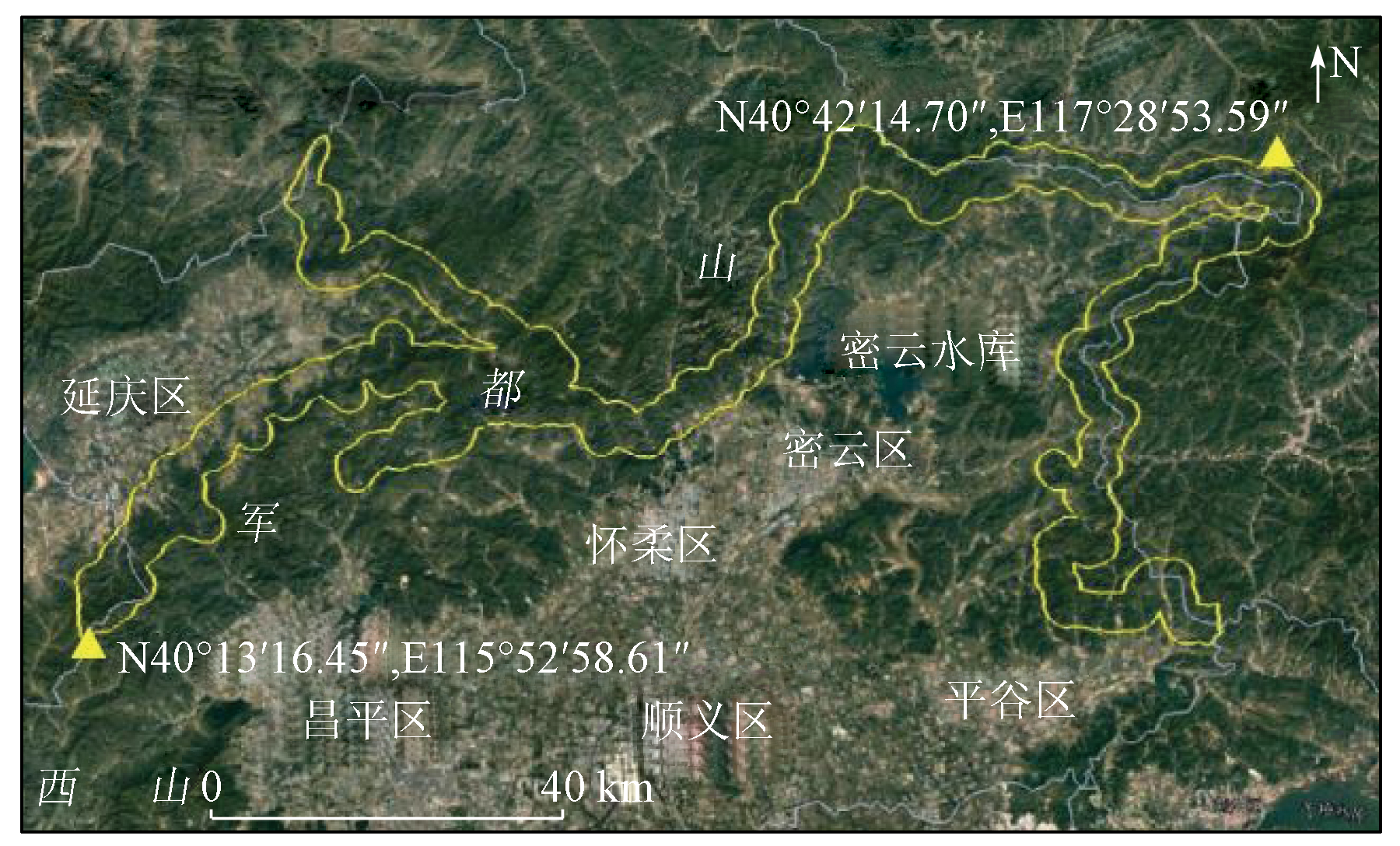
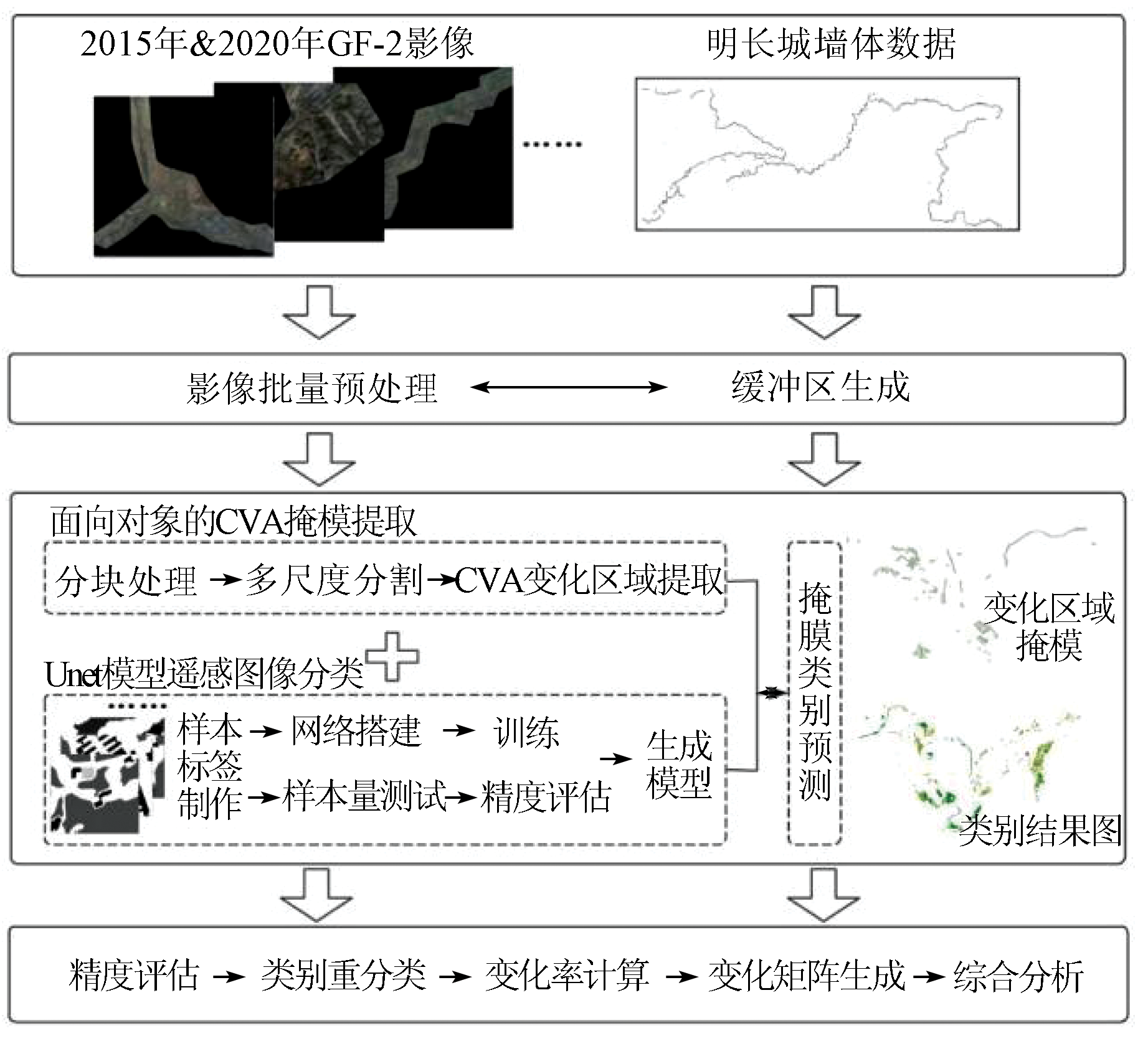
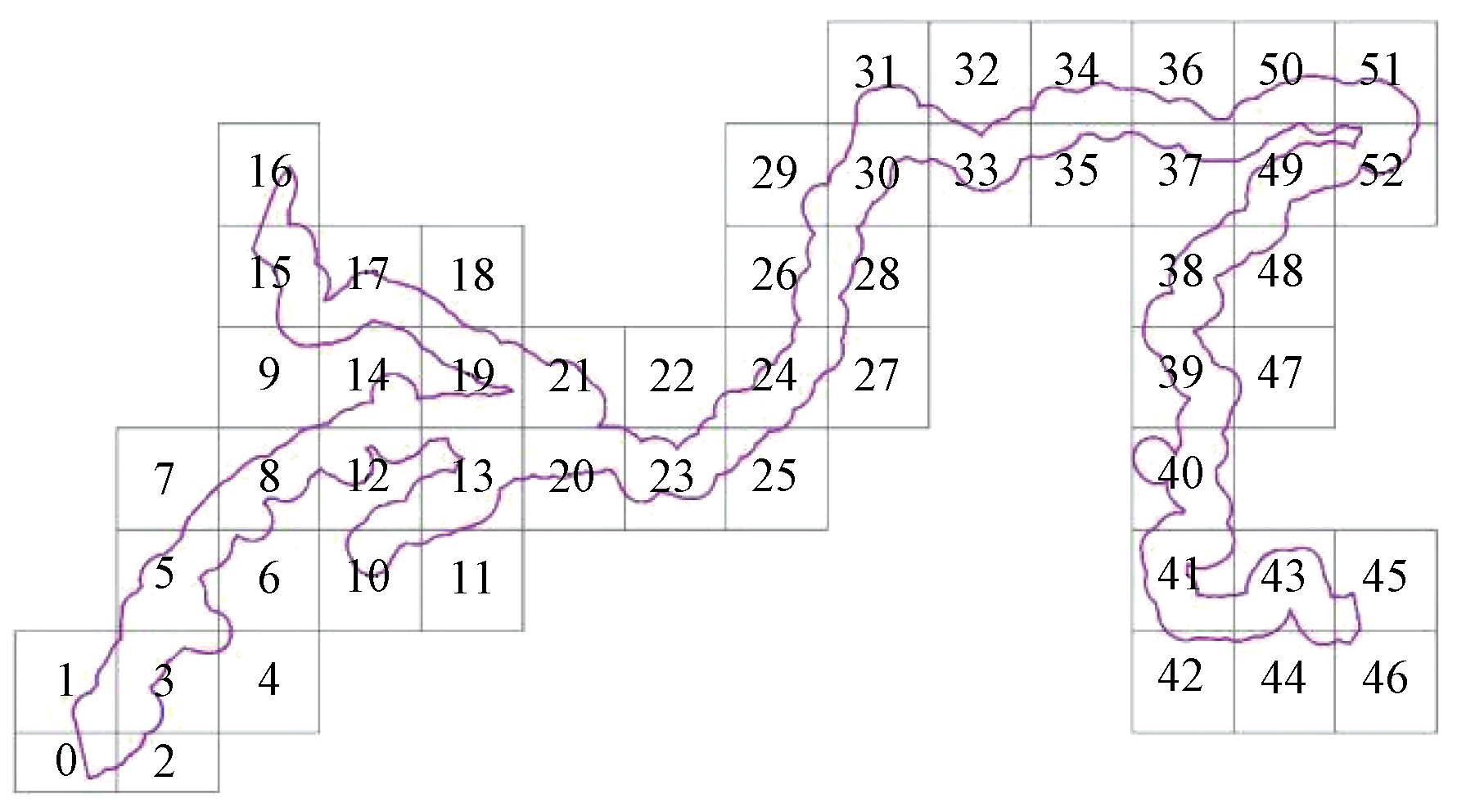
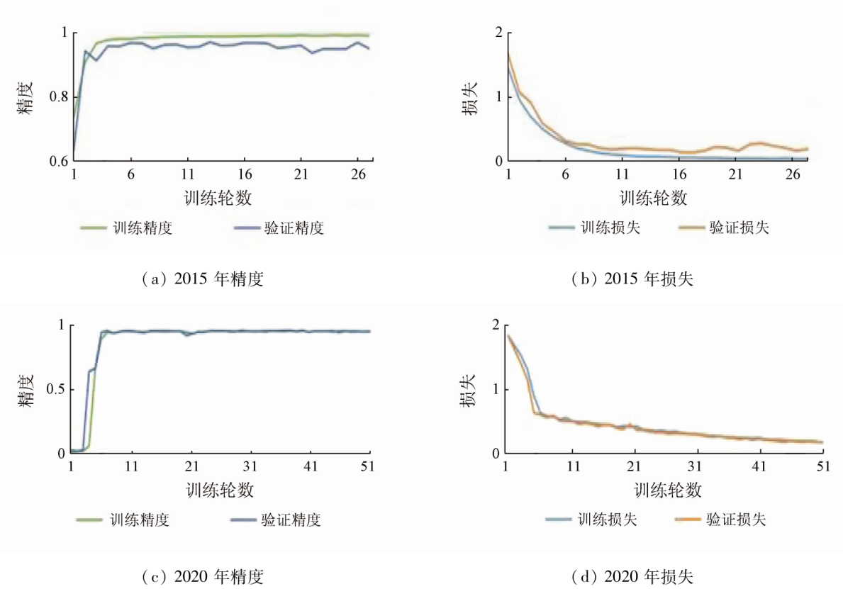
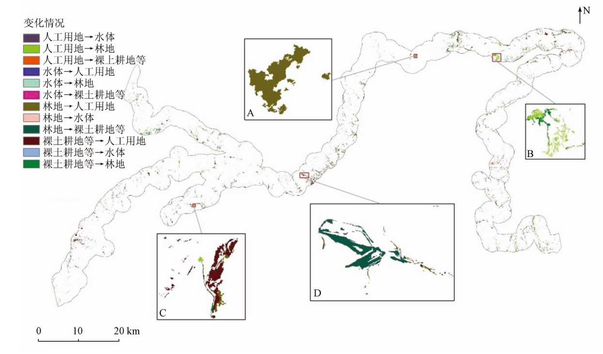
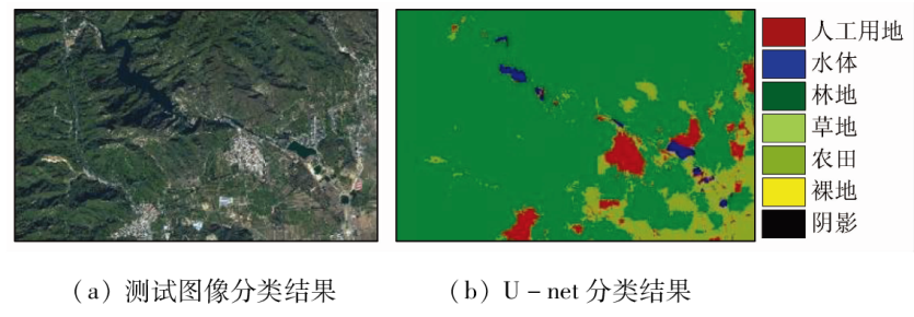
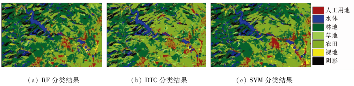
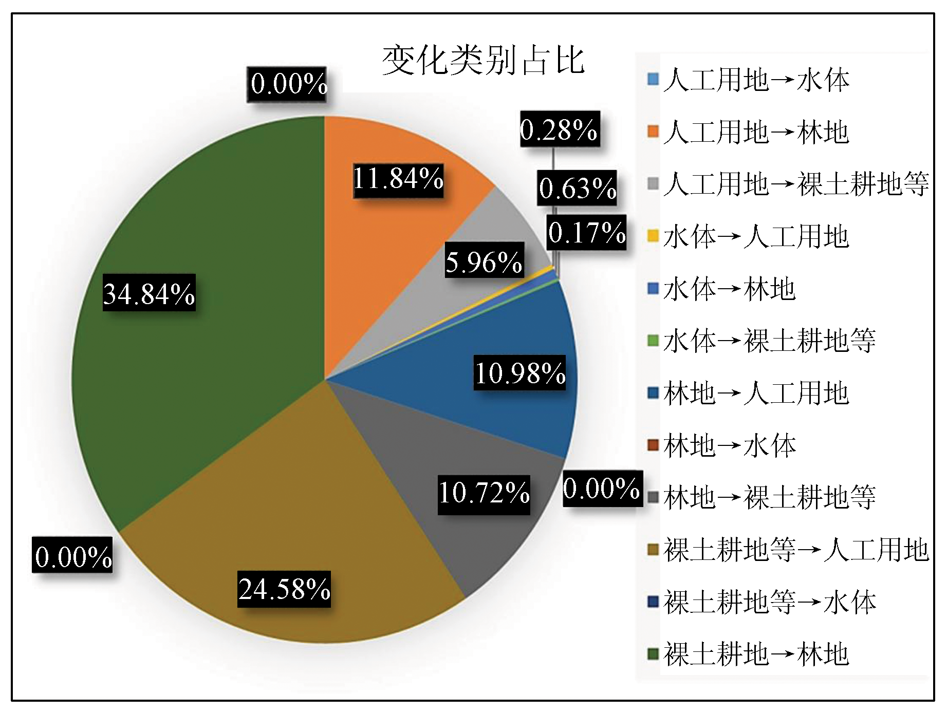
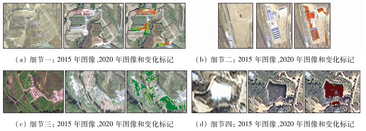
The coordinated economic and ecological development and the cultural landscape preservation of the Great Wall cultural zone are crucial for regional social sustainability. To meet the need for integrated monitoring and evaluation of large-scale linear cultural heritage, this study proposed a remote sensing dynamic monitoring method that integrates object-oriented change vector analysis and U-net deep learning. Based on the suppression of classified scattered noise and the accurate dynamic description of key regional environmental components, this study achieved the interpretation and information mining of the factors driving cultural landscape changes by combining socio-economic data and remote sensing change detection. Building on the 2-m-resolution GF-2 fused images from 2015 to 2020, the Beijing section of Ming Great Wall was examined through remote sensing change detection of surface elements and quantitative analysis of the land cover change matrix for its landscape corridor using methods including multiresolution segmentation, change vector analysis and extraction, and U-net image classification. The study reveals that the land cover along the Beijing section of Ming Great Wall cultural zone yielded a change rate of 0.098%, primarily manifested in the shift from bare land and farmland to forests and the growth of artificial land. Meanwhile, the ecological environment of the cultural zone exhibited positive development and an overall favorable protection state. The research results will provide technical support for the coordinated economic and ecological development and the sustainable preservation of the cultural landscape along the Beijing section of Ming Great Wall.
刘涵薇, 陈富龙, 廖亚奥. 明长城(北京段)遥感动态监测与影响驱动分析[J]. 自然资源遥感, 2023, 35(4): 255-263.
LIU Hanwei, CHEN Fulong, LIAO Yaao. Remote sensing dynamic monitoring and driving factor analysis for the Beijing section of Ming Great Wall. Remote Sensing for Natural Resources, 2023, 35(4): 255-263.
Tang Y Y, Cai C, Liu Z Y. Into Beijing Great Wall culture belt protection and development[C]// The Great Wall:A collection of papers celebrating the 70th anniversary of the founding of the people’s Republic of China, 2019:36-41.
[2]
Lu D, Mausel P, Brondízio E, et al. Change detection techniques[J]. International Journal of Remote Sensing, 2004, 25(12):2365-2401.
doi: 10.1080/0143116031000139863
[3]
Desclée B, Bogaert P, Defourny P. Forest change detection by statistical object-based method[J]. Remote Sensing of Environment, 2006, 102(1-2):1-11.
doi: 10.1016/j.rse.2006.01.013
[4]
Huo C, Zhou Z, Lu H, et al. Fast object-level change detection for VHR images[J]. IEEE Geoscience & Remote Sensing Letters, 2010, 7(1):118-122.
[5]
Li P, Xu H. Land-cover change detection using one-class support vector machine[J]. Photogrammetric Engineering & Remote Sensing, 2010, 76(3):255-263.
[6]
Duro D C, Franklin S E, Dubé M G. A comparison of pixel-based and object-based image analysis with selected machine learning algorithms for the classification of agricultural landscapes using SPOT-5 HRG imagery[J]. Remote Sensing of Environment, 2012, 118(6):259-272.
doi: 10.1016/j.rse.2011.11.020
Feng Q L, Niu B W, Zhu D H, et al. Review for deep learning in land use and land cover remote sensing classification[J]. Transactions of the Chinese Society for Agricultural Machinery, 2022, 53(3):1-17.
[8]
Zhang L, Zhang L, Bo D. Deep Learning for remote sensing data:A technical tutorial on the state of the art[J]. IEEE Geoscience and Remote Sensing Magazine, 2016, 4(2):22-40.
doi: 10.1109/MGRS.2016.2540798
[9]
Zhu X X, Tuia D, Mou L, et al. Deep learning in remote sensing:A comprehensive review and list of resources[J]. IEEE Geoscience and Remote Sensing Magazine, 2017, 5(4):8-36.
Yuan W, Zhou T, Xi Z S, et al. MUNet:A multi-branch adaptive deep learning network for remote sensing image semantic segmentation[J]. Journal of Geomatics Science and Technology, 2020, 37(6):581-588.
Li G Q, Bai Y Q, Yang X, et al. Automatic deep learning land cover classification methods of high-resolution remotely sensed images[J]. Journal of Geo-information Science, 2021, 23(9):1690-1704.
Xu Z Y, Zhou Y, Wang S X, et al. U-Net for urban green space classification in Gaofen-2 remote sensing images[J]. Journal of Image and Graphics, 2021, 26(3):700-713.
Han X, Han L, Li L Z, et al. Building change detection in high-resolution remote-sensing images based on deep learning[J]. Laser & Optoelectronics Progress, 2022, 59(10):55-63.
Ma X Y, Zhang X, Liu J L, et al. Research on urban development and security in border areas of China based on deep learning[J]. Remote Sensing for Natural Resources, 2022, 34(2):231-241.doi:10.6046/zrzyyg.2021157.
[15]
Thuestad A E, Tφmmervik H, Solbφ S A. Assessing the impact of human activity on cultural heritage in Svalbard:A remote sensing study of London[J]. The Polar Journal, 2015, 5(2):428-445.
doi: 10.1080/2154896X.2015.1068536
[16]
Elfadaly A, Attia W, Qelichi M M, et al. Management of cultural heritage sites using remote sensing indices and spatial analysis techniques[J]. Surveys in Geophysical, 2018, 39(12):1347-1377.
Wang C L, Xu D, Lin W P. Remote sensing monitoring and land cover change of the world cultural landscape heritage in Honghe Hani Terrace,China[J]. Ecology and Environmental Sciences, 2021, 30(2):233-241.
Mao N, Liu H P, Liu X P, et al. Optimal scale selection for multi-scale segmentation based on RMNE method[J]. Remote Sensing for Natural Resources, 2019, 31(2):10-16.doi:10.6046/gtzyyg.2019.02.02.
Wang X H, Tan B X, Li S M, et al. Object-oriented forest change detection based on multi-feature change vector analysis[J]. Forest Research, 2021, 34(1):98-105.
[20]
Maggiori E, Tarabalka Y, Charpiat G, et al. Fully convolutional neural networks for remote sensing image classification[C]// 2016 IEEE International Geoscience and Remote Sensing Symposium(IGARSS).Beijing,China.IEEE, 2016:5071-5074.
[21]
Ronneberger O, Fischer P, Brox T. U-Net:Convolutional networks for biomedical image segmentation[J]. International Conference on Medical Image Computing and Computer-Assisted Intervention, Cham:Spnnger, 2015, 18(9351):234-241.
[22]
Zhao X, Yuan Y, Song M, et al. Use of unmanned aerial vehicle imagery and deep learning unet to extract rice lodging[J]. Sensors (Basel,Switzerland), 2019, 19(18):3859-3872.
doi: 10.3390/s19183859
Yang Z S, Yang S Q, Yang R Y, et al. Classification method of land resources based on land use perspective[J]. Resources Science, 2021, 43(11):2173-2191.
doi: 10.18402/resci.2021.11.03
 2023, Vol. 35
  ), 陈富龙1,2(