Please wait a minute...
 
自然资源遥感  2025, Vol. 37 Issue (3): 45-53    DOI: 10.6046/zrzyyg.2024030
  矿山生态环境遥感监测专栏 本期目录 | 过刊浏览 | 高级检索 |
内蒙古中西部矿山地质环境遥感调查
李婷(), 叶丽娟(), 杨俊泉, 张静, 张云, 刘欢
中国地质调查局天津地质调查中心(华北地质科技创新中心),天津 300170
Remote sensing survey of geological environments in mines in west-central Inner Mongolia
LI Ting(), YE Lijuan(), YANG Junquan, ZHANG Jing, ZHANG Yun, LIU Huan
Tianjin Center, China Geological Survey(North China Center for Geoscience Innovation),Tianjin 300170, China
全文: PDF(3471 KB)   HTML  
输出: BibTeX | EndNote (RIS)      
摘要 治理矿山开采诱发的地质环境问题是当前生态系统保护和修复的重点方向,制定保护和修复战略规划前必须摸清生态环境现状与问题。基于2020年与2021年高分辨率遥感影像数据,结合实地调查,对内蒙古中西部矿山地质环境进行动态监测。结果显示,内蒙古中西部2021年采矿新增损毁土地面积达3 380.91 hm2,新增矿山恢复治理面积达1 801.31 hm2,总体上未实现“边开采,边治理”平衡。从损毁土地空间分布、损毁土地类型、开采矿种、恢复治理等角度分析矿山地质环境现状与问题,并依此提出下一步矿山地质环境遥感监测与恢复治理的建议。调查结果和建议可为当地开展矿山生态环境修复工作、矿产资源规划提供参考依据。
服务
把本文推荐给朋友
加入引用管理器
E-mail Alert
RSS
作者相关文章
李婷
叶丽娟
杨俊泉
张静
张云
刘欢
关键词 遥感监测矿山地质环境生态修复成矿带战略性矿产    
Abstract

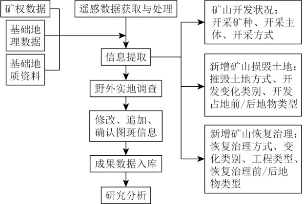
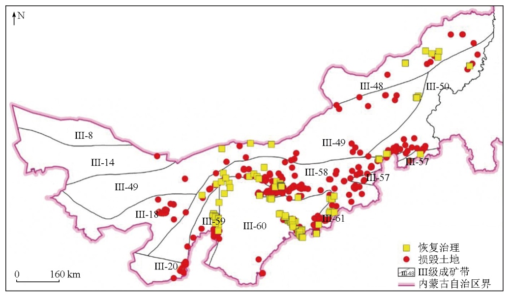
Addressing mining-induced challenges in geological environments is currently a priority for ecosystem conservation and restoration. A prerequisite for formulating effective conservation and restoration strategic planning is to thoroughly ascertain the ecological status and challenges. Based on high-resolution remote sensing image data from 2020 and 2021, and field investigations, this study dynamically monitored the geological environments in mines in west-central Inner Mongolia. The results indicate that in 2021, mining activities in west-central Inner Mongolia led to an additional 3 380.91 hm2 of destroyed land, while the newly restored and managed area reached 1 801.31 hm2, suggesting an overall imbalance between mining and management. This study analyzed the status and challenges of geological environments in mines from the perspectives of the spatial distribution and type of destroyed land, mineral species, and restoration and management. Furthermore, this study proposed recommendations for subsequent remote sensing monitoring, restoration, and management of geological environments in mines. Overall, the results and recommendations of this study can serve as a reference for local ecological environment restoration and mineral resource planning.

Key wordsremote sensing monitoring    geological environment in a mine    ecological restoration    metallogenic belt    strategic mineral
收稿日期: 2024-01-17      出版日期: 2025-07-01
ZTFLH:  TP79  
基金资助:中国地质调查局地质调查项目“华北地区自然资源动态监测与风险评估”(DD20230101)
通讯作者: 叶丽娟(1988-),女,硕士,高级工程师,主要研究方向为岩石地球化学、遥感地质。Email: didaduzhe2007@163.com
作者简介: 李婷(1988-),女,硕士,助理工程师,主要研究方向为遥感地质应用。Email: snailcumt@126.com
引用本文:   
李婷, 叶丽娟, 杨俊泉, 张静, 张云, 刘欢. 内蒙古中西部矿山地质环境遥感调查[J]. 自然资源遥感, 2025, 37(3): 45-53.
LI Ting, YE Lijuan, YANG Junquan, ZHANG Jing, ZHANG Yun, LIU Huan. Remote sensing survey of geological environments in mines in west-central Inner Mongolia. Remote Sensing for Natural Resources, 2025, 37(3): 45-53.
链接本文:  
https://www.gtzyyg.com/CN/10.6046/zrzyyg.2024030      或      https://www.gtzyyg.com/CN/Y2025/V37/I3/45
Fig.1  研究区Ⅲ级成矿带分布图(据文献[25]修改)(审图号:GS京(2025)0941号)
Ⅲ-8.觉罗塔格—黑鹰山Cu-Ni-Fe-Au-Ag-Mo-W-石膏-硅石灰-膨润土-煤成矿带; Ⅲ-14.金窝子—公婆泉—东七一山Fe-Cu-Au-Pb-Zn-Mn-W-Sn-Rb-V-U-P成矿带; Ⅲ-18.阿拉善陆块Cu-Ni-Pt-Fe-REE-P-石墨-芒硝-盐类成矿带; Ⅲ-20.河西走廊Fe-Mn-萤石-盐类-凹凸棒石-石油成矿带; Ⅲ-48.东乌珠穆沁旗—嫩江Cu-Mo-Pb-Zn-Au-W-Sn-Cr-煤-萤石-石油-天然气成矿带; Ⅲ-49.白乃庙—锡林郭勒Fe-Cu-Mo-Pb-Zn-Mn-Cr-Au-Ge-煤-天然碱-芒硝成矿带; Ⅲ-50.突泉—翁牛特Pb-Zn-Cu-Mo-Au成矿带; Ⅲ-57.华北陆块北缘东段Fe-Cu-Mo-Pb-Zn-Au-Ag-Mn-U-P-煤-膨润土成矿带; Ⅲ-58.华北陆块北缘西段Au-Fe-Nb-REE-Cu-Pb-Zn-Ag-Ni-Pt-W-石墨-白云母成矿带; Ⅲ-59.鄂尔多斯西缘(陆缘坳褶带)Fe-Pb-Zn-P-石膏-芒硝成矿带; Ⅲ-60.鄂尔多斯(盆地)U-石油-天然气-煤-盐类成矿带; Ⅲ-61.山西(断隆)Fe-铝土矿-石膏-煤-煤层气成矿带。下同。
Fig.2  研究路线
Fig.3  2021年度内蒙古中西部新增采矿损毁土地与恢复治理遥感监测图(审图号:GS京(2025)0941号)
Ⅲ级成矿带 损毁土地
面积/hm2
损毁土地
图斑/个
恢复治理
面积/hm2
恢复治理
率/%
Ⅲ-60鄂尔多斯(盆地)U-石油-天然气-煤-盐类成矿带 1 597.57 110 1 128.95 41.41
Ⅲ-58华北陆块北缘西段Au-Fe-Nb-REE-Cu-Pb-Zn-Ag-Ni-Pt-W-石墨-白云母成矿带 615.54 332 92.42 13.05
Ⅲ-61山西(断隆)Fe-铝土矿-石膏-煤-煤层气成矿带 398.22 38 132.62 24.98
Ⅲ-49白乃庙—锡林郭勒Fe-Cu-Mo-Pb-Zn-Mn-Cr-Au-Ge-煤-天然碱-芒硝成矿带 210.50 38 229.17 52.12
Ⅲ-59鄂尔多斯西缘(陆缘坳褶带)Fe-Pb-Zn-P-石膏-芒硝成矿带 205.89 35 56.79 21.62
Ⅲ-50突泉—翁牛特Pb-Zn-Cu-Mo-Au成矿带 205.20 29 52.79 20.46
Ⅲ-18阿拉善陆块Cu-Ni-Pt-Fe-REE-P-石墨-芒硝-盐类成矿带 62.81 28 0 0
Ⅲ-20河西走廊Fe-Mn-萤石-盐类-凹凸棒石-石油成矿带 34.90 15 0 0
Ⅲ-48东乌珠穆沁旗—嫩江Cu-Mo-Pb-Zn-Au-W-Sn-Cr-煤-萤石-石油-天然气成矿带 31.09 19 107.64 77.59
Ⅲ-57华北陆块北缘东段Fe-Cu-Mo-Pb-Zn-Au-Ag-Mn-U-P-煤-膨润土成矿带 17.39 9 0.93 5.08
Ⅲ-14金窝子—公婆泉—东七一山Fe-Cu-Au-Pb-Zn-Mn-W-Sn-Rb-V-U-P成矿带 1.81 1 0 0
合计 3 380.91 654 1 801.31 34.76
Tab.1  内蒙古中西部2021年新增矿山损毁土地与恢复治理分布
损毁土地类型 损毁土地面积/hm2 恢复治理
率/%
能源矿产 金属矿产 非金属矿产
采场 1 350.76 58.15 173.42 43.20
中转场地 148.28 73.05 91.57 15.79
固体废弃物 998.28 321.86 106.36 26.20
矿山建筑 28.83 12.95 17.40 33.21
合计 2 526.15 466.01 388.75 34.76
Tab.2  内蒙古中西部2021年新增损毁土地类型与恢复治理统计
战略性矿产 损毁土地
面积/hm2
恢复治理
面积/hm2
恢复治理
率/%
煤矿 2 526.15 1 580.89 38.49
铁矿 371.43 18.01 4.62
金矿 44.42 2.54 5.41
钼矿 22.88 0 0
萤石(普通)矿 8.04 0.51 6.02
石墨矿 1.30 0 0
合计 2 974.22 1 601.95 35.01
Tab.3  内蒙古中西部2021年战略性矿产新增矿山损毁土地与恢复治理面积统计
矿山主
体状态
矿种类型 恢复治理模式 总计
生态
恢复
土地
复垦
灾害
整治
综合
治理
生产矿山 能源矿产 11 0 5 28 44
金属矿产 2 0 0 0 2
非金属矿产 11 1 1 0 13
废弃矿山 能源矿产 22 0 2 9 33
金属矿产 6 0 0 0 6
非金属矿产 41 9 7 0 57
合计 93 10 15 37 155
Tab.4  Statistical table of land rehabilitation modes in west-central Inner Mongolia in 2021(处)
Fig.4  生态恢复模式示例
Fig.5  灾害整治模式示例
Fig.6  土地复垦模式示例
Fig.7  综合治理模式示例
[1] 陈晶, 余振国, 孙晓玲, 等. 基于山水林田湖草统筹视角的矿山生态损害及生态修复指标研究[J]. 环境保护, 2020, 48(12):58-63.
Chen J, Yu Z G, Sun X L, et al. Study on ecological damage of mine and the ecological remediation indexes in view of the holistic approach to conserving mountains,rivers,forests,farmlands,lakes,and grasslands[J]. Environmental Protection, 2020, 48(12):58-63.
[2] 马丽, 田华征, 康蕾. 黄河流域矿产资源开发的生态环境影响与空间管控路径[J]. 资源科学, 2020, 42(1):137-149.
doi: 10.18402/resci.2020.01.14
Ma L, Tian H Z, Kang L. Eco-environmental impact and spatial control of mineral resources exploitation in the Yellow River basin[J]. Resources Science, 2020, 42(1):137-149.
doi: 10.18402/resci.2020.01.14
[3] 杨金中, 姚维岭, 陈栋, 等. 历史遗留矿山核查方法研究[J]. 自然资源遥感, 2022, 34(3):10-16.doi:10.6046/zrzyyg.2021311.
Yang J Z, Yao W L, Chen D, et al. A method for determining historically abandoned mines[J]. Remote Sensing for Natural Resources, 2022, 34(3):10-16.doi:10.6046/zrzyyg.2021311.
[4] 武强, 刘宏磊, 陈奇, 等. 矿山环境修复治理模式理论与实践[J]. 煤炭学报, 2017, 42(5):1085-1092.
Wu Q, Liu H L, Chen Q, et al. Theoretical study of mine geo-environmental restoration model and its application[J]. Journal of China Coal Society, 2017, 42(5):1085-1092.
[5] 常江, 李灿坤, 冯姗姗, 等. 煤炭城市山水林田湖草生态保护修复分区及规划策略研究——以古交市为例[J]. 生态经济, 2021, 37(6):222-229.
Chang J, Li C K, Feng S S, et al. Research on zoning and planning strategy of ecological protection and restoration of mountain-water-forest-field-lake and grassland in coal city:Taking Gujiao City as an example[J]. Ecological Economy, 2021, 37(6):222-229.
[6] 彭苏萍, 毕银丽. 黄河流域煤矿区生态环境修复关键技术与战略思考[J]. 煤炭学报, 2020, 45(4):1211-1221.
Peng S P, Bi Y L. Strategic consideration and core technology about environmental ecological restoration in coal mine areas in the Yellow River basin of China[J]. Journal of China Coal Society, 2020, 45(4):1211-1221.
[7] 张吉雄, 鞠杨, 张强, 等. 矿山生态环境低损害开采体系与方法[J]. 采矿与岩层控制工程学报, 2019(2):50-62.
Zhang J X, Ju Y, Zhang Q, et al. Low ecological environment damage technology and method in coal mines[J]. Journal of Mining and Strata Control Engineering, 2019(2):50-62.
[8] 许文佳, 白中科, 杨金中, 等. 黄河源区矿山开发生态受损识别诊断[J]. 中国土地科学, 2022, 36(4):118-126.
Xu W J, Bai Z K, Yang J Z, et al. Identification and diagnosis of ecosystem damaged by mining development in the source area of the Yellow River[J]. China Land Science, 2022, 36(4):118-126.
[9] 殷亚秋, 杨金中, 汪洁, 等. 长江经济带废弃矿山占损土地遥感调查与生态修复对策[J]. 国土资源遥感, 2020, 32(2):170-176.doi:10.6046/gtzyyg.2020.02.22.
Yin Y Q, Yang J Z, Wang J, et al. Remote sensing survey of land occupied and damaged by abandoned mines along the Yangtze River Economic Belt and research on ecological remediation countermeasures[J]. Remote Sensing for Natural Resources, 2020, 32(2):170-176.doi:10.6046/gtzyyg.2020.02.22.
[10] 刘立, 高俊华, 余德清. 基于遥感的湖南省矿山占地监测与分析[J]. 地理空间信息, 2019, 17(1):41-46,124.
Liu L, Gao J H, Yu D Q. Monitoring and analysis of mine land occupation in Hunan Province based on remote sensing[J]. Geospatial Information, 2019, 17(1):41-46,124.
[11] 黄栋良, 梅金华, 何卫平. 湖南矿山地质环境破坏影响评价及防治研究[J]. 矿业研究与开发, 2021, 41(9):118-124.
Huang D L, Mei J H, He W P. Impact evaluation and prevention research on mine geological environment destruction in Hunan[J]. Mining Research and Development, 2021, 41(9):118-124.
[12] 殷亚秋, 蒋存浩, 鞠星, 等. 海南岛2018年矿山地质环境遥感评价和生态修复对策[J]. 自然资源遥感, 2022, 34(2):194-202.doi:10.6046/zrzyyg.2021136.
Yin Y Q, Jiang C H, Ju X, et al. Remote sensing evaluation of mine geological environment of Hainan Island in 2018 and ecological restoration countermeasures[J]. Remote Sensing for Natural Resources, 2022, 34(2):194-202.doi:10.6046/zrzyyg.2021136.
[13] 杨金中, 许文佳, 姚维岭, 等. 全国采矿损毁土地分布与治理状况及存在问题[J]. 地学前缘, 2021, 28(4):83-89.
doi: 10.13745/j.esf.sf.2020.10.8
Yang J Z, Xu W J, Yao W L, et al. Land destroyed by mining in China:Damage distribution,rehabilitation status and existing problems[J]. Earth Science Frontiers, 2021, 28(4):83-89.
[14] 汪洁, 刘小杨, 杨金中, 等. 基于国产高空间分辨率卫星数据的浙江省矿山环境恢复治理典型模式分析[J]. 国土资源遥感, 2020, 32(3):216-221.doi:10.6046/gtzyyg.2020.03.28.
Wang J, Liu X Y, Yang J Z, et al. Typical model analysis of mine geological environment restoration and management in Zhejiang Province based on domestic high-resolution satellite data[J]. Remote Sensing for Natural Resources, 2020, 32(3):216-221.doi:10.6046/gtzyyg.2020.03.28.
[15] 高俊华, 刘莎莎, 杨金中, 等. 基于遥感的露天煤矿集中区地质环境灰关联评价——以准格尔煤田为例[J]. 国土资源遥感, 2021, 33(1):183-190.doi:10.6046/gtzyyg.2020006.
Gao J H, Liu S S, Yang J Z, et al. Gray correlation evaluation of geo-logical environment in the open-pit coal mine concentration area based on remote sensing:A case study of the Zhungeer Coalfield[J]. Remote Sensing for Natural Resources, 2021, 33(1):183-190.doi:10.6046/gtzyyg.2020006.
[16] 安志宏, 程玉书, 汪宝存, 等. 辽源市矿山地质环境恢复治理遥感监测与整治模式一体化研究[J]. 地质力学学报, 2017, 23(4):631-637.
An Z H, Cheng Y S, Wang B C, et al. A study on the integration of remote sensing monitoring and regulation model in restoration and treatment of mine geological environment in Liaoyuan[J]. Journal of Geomechanics, 2017, 23(4):631-637.
[17] 董双发, 梁鑫, 吴蔚, 等. 内蒙古西部地区矿山遥感调查与监测[J]. 中国地质调查, 2016, 3(5):48-53.
Dong S F, Liang X, Wu W, et al. Mine remote sensing investigation and monitoring in western Inner Mongolia[J]. Geological Survey of China, 2016, 3(5):48-53.
[18] 叶丽娟, 段霄龙, 李婷, 等. 河北省采矿损毁土地分布及治理状况分析[J]. 自然资源遥感, 2024, 36(4):75-81.doi:10.6046/gtzyyg.2023186.
Ye L J, Duan X L, Li T, et al. Distribution and rehabilitation status of lands destroyed by mining:A case study of Hebei Province[J]. Remote Sensing for Natural Resources, 2024, 36(4):75-81.doi:10.6046/gtzyyg.2023186.
[19] 刘欢, 刘晓雪, 张云, 等. 河南省2021年新增矿山损毁和恢复治理遥感监测状况及存在问题[J/OL]. 自然资源遥感, 2024(2024-03-06)[2024-08-13].
Liu H, Liu X X, Zhang Y, et al. Remote sensing monitoring Status and existing Problems of new mine damage and mine rehabilitation in Henan Province in 2021[J/OL]. Remote Sensing for Natural Resources, 2024(2024-03-06)[2024-08-13].
[20] 胡宇霞, 龚吉蕊, 朱趁趁, 等. 基于生态系统服务簇的内蒙古荒漠草原生态系统服务的空间分布特征[J]. 草业学报, 2023, 32(4):1-14.
doi: 10.11686/cyxb2022142
Hu Y X, Gong J R, Zhu C C, et al. Spatial distribution of ecosystem services in the desert steppe,Inner Mongolia based on ecosystem service bundles[J]. Acta Prataculturae Sinica, 2023, 32(4):1-14.
[21] 余楚, 李剑锋, 张翼龙. 河流表层沉积物重金属赋存形态及生态风险评价——以内蒙古白音诺尔矿区为例[J]. 东北师大学报(自然科学版), 2022, 54(3):131-137.
Yu C, Li J F, Zhang Y L. Morphological characteristics and ecological risk assessment of heavy metals in river surface sediments in Baiyinnuoer Mine,Inner Mongolia[J]. Journal of Northeast Normal University (Natural Science Edition), 2022, 54(3):131-137.
[22] 卞正富, 于昊辰, 侯竟, 等. 西部重点煤矿区土地退化的影响因素及其评估[J]. 煤炭学报, 2020, 45(1):338-350.
Bian Z F, Yu H C, Hou J, et al. Influencing factors and evaluation of land degradation of 12 coal mine areas in Western China[J]. Journal of China Coal Society, 2020, 45(1):338-350.
[23] 邰生霞, 何桥, 毕佳. 内蒙古西部区环境评价[J]. 干旱区研究, 2007(3):364-368.
Tai S X, He Q, Bi J. Study on appraisal and conservation measures of entironment in West Inner Mongolia[J]. Arid Zone Research, 2007(3):364-368.
[24] 黄垒, 李磊, 王威. 基于GIS的华北地区自然资源综合评价区划研究[J]. 华北地质, 2023, 46(4):83-88.
Huang L, Li L, Wang W. Research on comprehensive evaluation and regionalization of natural resources in North China based on GIS[J]. North China Geology, 2023, 46(4):83-88.
[25] 李俊建, 彭翼, 张彤, 等. 华北地区成矿单元划分[J]. 华北地质, 2021, 44(3):4-24.
Li J J, Peng Y, Zhang T, et al. Division of metallogenic units in North China[J]. North China Geology, 2021, 44(3):4-24.
[26] 刘欢, 张云, 黄旭红, 等. 遥感技术在内蒙古自治区中西部重点矿区开采监测中的应用[J]. 华北地质, 2021(4):55-60.
Liu H, Zhang Y, Huang X H, et al. Application of remote sensing technology in mining monitoring in midwest major mining area of Inner Mongolia[J]. North China Geology, 2021(4):55-60.
[27] 刘晓雪, 陈东磊, 黄旭红, 等. 遥感技术在矿山开采状况监测中的应用——以山西省为例[J]. 华北地质, 2023, 46(3):82-88.
Liu X X, Chen D L, Huang X H, et al. The application of remote sensing technology in the monitoring of mining:A case study of Shanxi Province[J]. North China Geology, 2023, 46(3):82-88.
[28] 胡振琪, 肖武, 赵艳玲. 再论煤矿区生态环境“边采边复”[J]. 煤炭学报, 2020, 45(1):351-359.
Hu Z Q, Xiao W, Zhao Y L. Re-discussion on coal mine eco-environment concurrent mining and reclamation[J]. Journal of China Coal Society, 2020, 45(1):351-359.
[29] 阎仲康, 曹银贵, 李志涛, 等. 内蒙古东部草原区矿山生态修复研究:关键技术与减碳路径[J]. 农业资源与环境学报, 2023, 40(3):570-582.
Yan Z K, Cao Y G, Li Z T, et al. Ecological restoration of mines in eastern grassland area of Inner Mongolia,China:Key technologies and carbon reduction paths[J]. Journal of Agricultural Resources and Environment, 2023, 40(3):570-582.
[30] 张仙, 李伟, 陈理, 等. 露天开采矿区要素遥感提取研究进展及展望[J]. 自然资源遥感, 2023, 35(2):25-33.doi:10.6046/zrzyyg.2022141.
Zhang X, Li W, Chen L, et al. Research progress and prospect of remote sensing-based featureextraction of opencast mining areas[J]. Remote Sensing for Natural Resources, 2023, 35(2):25-33.doi:10.6046/zrzyyg.2022141.
[31] 陈毓川, 薛春纪, 王登红, 等. 华北陆块北缘区域矿床成矿谱系探讨[J]. 高校地质学报, 2003, 9(4):520-535.
Chen Y C, Xue C J, Wang D H, et al. A discussion on the regional mineralizing pedigree of the ore deposits in the northern margin of the North China landmass[J]. Geological Journal of China Universities, 2003, 9(4):520-535.
[1] 赵丽君, 刘欢, 张云, 杨俊泉, 王威, 陈东磊. 山东省矿山损毁土地和治理状况2021年度监测与分析[J]. 自然资源遥感, 2025, 37(3): 17-22.
[2] 刘欢, 刘晓雪, 张云, 杨俊泉, 曾辉. 河南省2021年新增矿山损毁和恢复治理遥感监测状况及存在问题[J]. 自然资源遥感, 2025, 37(3): 23-31.
[3] 孙娅琴, 邸宝刚, 邢宇, 安娜, 张仙. 长江经济带湖北段废弃露天矿山生态修复遥感动态监测和生态修复效果评价[J]. 自然资源遥感, 2025, 37(3): 32-44.
[4] 石海岗, 梁春利, 薛庆, 张恩, 章新益, 张建永, 张春雷, 程旭. 基于卫星遥感的秦山核电周边海域温度分布研究[J]. 自然资源遥感, 2025, 37(1): 152-160.
[5] 康辉, 窦文章, 韩灵怡, 丁梓越, 吴亮廷, 侯璐. 基于DeepLabv3+模型的地表水体快速遥感监测[J]. 自然资源遥感, 2024, 36(4): 117-123.
[6] 赵玉灵, 杨金中, 孙卫东, 于浩, 邢宇, 陈栋, 马新营, 王体鑫, 王聪. 伊犁河谷矿山地质环境评价分析与生态恢复治理对策[J]. 自然资源遥感, 2024, 36(4): 23-30.
[7] 叶丽娟, 段霄龙, 李婷, 张静, 张云, 陈东磊. 河北省采矿损毁土地分布及治理状况分析[J]. 自然资源遥感, 2024, 36(4): 75-81.
[8] 孙禧勇, 刘稼丰, 范景辉, 张文凯, 石利娟, 邱玉宝, 朱发容. 积雪遥感监测产品研究与应用进展[J]. 自然资源遥感, 2024, 36(3): 13-27.
[9] 和海霞, 李博. 青海大通“8·18”山洪灾害特征及风险分析[J]. 自然资源遥感, 2024, 36(2): 135-141.
[10] 邢宇, 王静雅, 杨金中, 陈栋, 杜晓敏, 郭靖凯, 宋丽聪. 全国废弃露天矿山采矿用地分布状况与存在问题[J]. 自然资源遥感, 2024, 36(2): 21-26.
[11] 马晓雪, 焦润成, 曹颖, 南赟, 王晟宇, 郭学飞, 赵丹凝, 闫驰, 倪璇. 重大工程建设中地质灾害综合遥感监测技术方法应用——以北京2022冬奥会延庆赛区为例[J]. 自然资源遥感, 2024, 36(2): 248-256.
[12] 周小迦. 丘陵地带耕地撂荒遥感监测应用研究[J]. 自然资源遥感, 2024, 36(1): 235-241.
[13] 黄卓, 孙建国, 冯春月, 徐鹏, 杨浩, 侯文兵. 基于生态系统服务变化的河西地区生态修复分区[J]. 自然资源遥感, 2023, 35(4): 236-243.
[14] 于航, 安娜, 汪洁, 邢宇, 许文佳, 步凡, 王晓红, 杨金中. 黔西南采煤塌陷区高分遥感动态监测——以六盘水市煤矿采空塌陷区为例[J]. 自然资源遥感, 2023, 35(3): 310-318.
[15] 李星佑, 张飞, 王筝. 土壤盐渍化遥感监测模型构建方法现状与发展趋势[J]. 自然资源遥感, 2022, 34(4): 11-21.
Viewed
Full text


Abstract

Cited

  Shared   
  Discussed   
京ICP备05055290号-2
版权所有 © 2015 《自然资源遥感》编辑部
地址:北京学院路31号中国国土资源航空物探遥感中心 邮编:100083
电话:010-62060291/62060292 E-mail:zrzyyg@163.com
本系统由北京玛格泰克科技发展有限公司设计开发