Estimation and spatial pattern analysis of forest above-ground biomass based on Sentinel-2 and GEDI data
WANG Lu1,2,3(), JI Yongjie1,2,3(), DONG Wenquan4, ZHANG Wangfei5
1. College of Soil and Water Conservation,Southwest Forestry University,Kunming 650224,China 2. Key Laboratory of Ecological Environment Evolution and Pollution Control in Mountainous and Rural Areas of Yunnan Province,Kunming 650224,China 3. Yunnan Zhanyi Karst Ecosystem Positioning Observation and Research Station,National Forestry and Grassland Administration,Kunming 650224,China 4. Royal Botanic Gardens Edinburgh,Edinburgh EH3 5LR,UK 5. College of Forestry,Southwest Forestry University,Kunming 650224,China
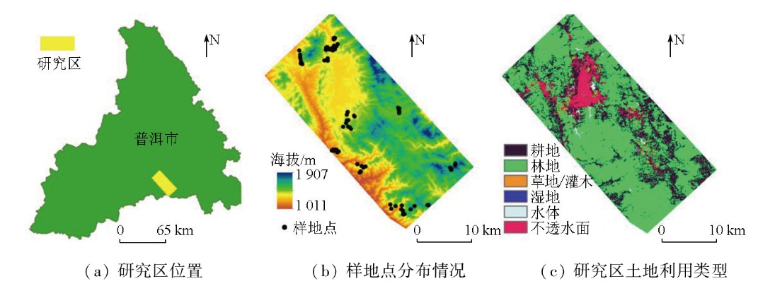
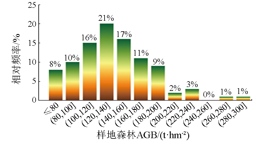
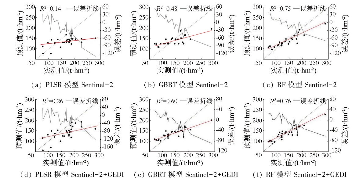
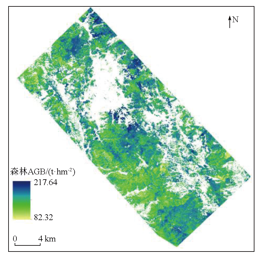
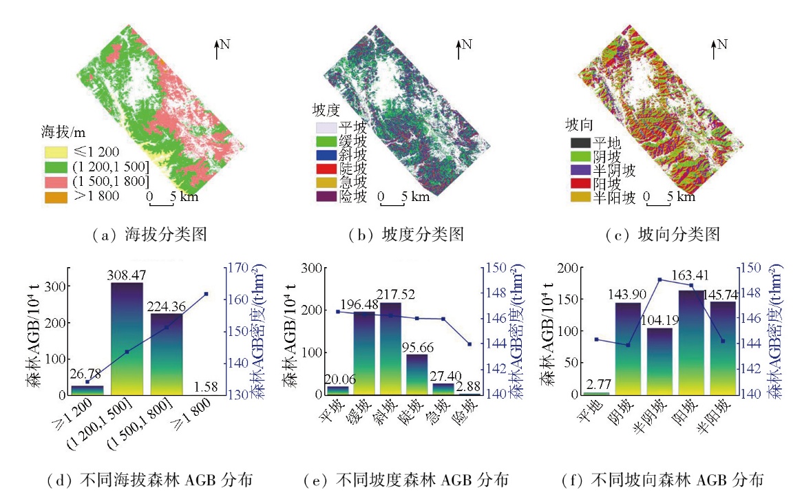
Forest above-ground biomass (AGB) is recognized as an important indicator of forest productivity. Rapid and accurate estimation of forest AGB is crucial for sustainable forest management and carbon cycle research. Based on spaceborne light detection and ranging (LiDAR) data from the global ecosystem dynamic investigation (GEDI) and Sentinel-2 optical data,this study extracted GEDI L2B,Sentinel-2 remote sensing features,and topographic factors (elevation,aspect,and slope) in the study area. Among them,variables were determined through Pearson correlation analysis. Then,this study constructed the partial least squares regression (PLSR),gradient boosting regression tree (GBRT),and random forest (RF) models for forest AGB inversion. Consequently,this study estimated these models’ potential for forest AGB estimation and analyzed the spatial distribution differences of forest AGB. The results indicate that the estimation using multi-source data consistently outperformed that using single-source data. Among them,the RF model based on GEDI and Sentinel-2 data exhibited the best performance (R2=0.76,root mean square error (RMSE)=23.02 t/hm2),followed by the GBRT model,while the PLSR model performed the worst (R2=0.26). In terms of spatial distribution,within the elevation range of 1 200~1 800 m,forest AGB density increased with elevation. Slope variation had little effect on forest AGB density,but a pronounced decrease in AGB density was observed on steep slopes. Aspect analysis showed that semi-shaded and sunny slopes exhibited high forest AGB density,while shaded and semi-sunny slopes presented similar values. Slope-aspect interaction analysis revealed that sunny and semi-sunny slopes displayed the highest total forest AGB on gentle and moderate slopes,respectively. In contrast,forest AGB significantly decreased across all orientations on flat and steep slopes,with a more significant decline observed on shaded and semi-shaded slopes. These findings provide a scientific basis for formulating forest protection and cultivation policies at the provincial level.
王璐, 姬永杰, 董文全, 张王菲. 结合Sentinel-2和GEDI数据的森林地上生物量估测和空间格局分析[J]. 自然资源遥感, 2025, 37(5): 224-232.
WANG Lu, JI Yongjie, DONG Wenquan, ZHANG Wangfei. Estimation and spatial pattern analysis of forest above-ground biomass based on Sentinel-2 and GEDI data. Remote Sensing for Natural Resources, 2025, 37(5): 224-232.
Wang M J, Sun R, Xiao Z Q. Estimation of forest canopy height and aboveground biomass from spaceborne LiDAR and Landsat imageries in Maryland[J]. Remote Sensing, 2018, 10(2):344.
Xue C Q, Xu Q H, Lin L P, et al. Biomass dynamic predicting for Schima superba in Guangdong based on allometric and theoretical growth equation[J]. Scientia Silvae Sinicae, 2019, 55(7):86-94.
Wen X, Liu K, Cao J J, et al. Estimation of mangrove aboveground biomass in China using forest canopy height through an allometric equation[J]. Tropical Geography, 2023, 43(1):1-11.
doi: 10.13284/j.cnki.rddl.003616
[4]
Sun G Q, Ranson K J, Guo Z, et al. Forest biomass mapping from Lidar and Radar synergies[J]. Remote Sensing of Environment, 2011, 115(11):2906-2916.
[5]
Foody G M, Boyd D S, Cutler M E J. Predictive relations of tropical forest biomass from Landsat TM data and their transferability between regions[J]. Remote Sensing of Environment, 2003, 85(4):463-474.
Li W, Niu Z, Wang C, et al. Forest above-ground biomass estimation at plot and tree levels using airborne LiDAR data[J]. Journal of Remote Sensing, 2015, 19(4):669-679.
[7]
Luo S Z, Wang C, Xi X H, et al. Fusion of airborne LiDAR data and hyperspectral imagery for aboveground and belowground forest biomass estimation[J]. Ecological Indicators, 2017, 73:378-387.
[8]
Dubayah R, Blair J B, Goetz S, et al. The global ecosystem dynami-cs investigation:High-resolution laser ranging of the earth’s forests and topography[J]. Science of Remote Sensing, 2020, 1:100002.
Tian G S, Zhou X C, Hao Y Z, et al. Optimization model of forest aboveground biomass based on MGEDI canopy height:A case study in Fujian,China[J]. Acta Ecologica Sinica, 2024, 44(16):7264-7277.
[10]
Guo Q Y, Du S H, Jiang J B, et al. Combining GEDI and sentinel data to estimate forest canopy mean height and aboveground biomass[J]. Ecological Informatics, 2023, 78:102348.
[11]
Khati U, Lavalle M, Singh G. The role of time-series L-band SAR and GEDI in mapping sub-tropical above-ground biomass[J]. Frontiers in Earth Science, 2021, 9:752254.
[12]
Silva C A, Duncanson L, Hancock S, et al. Fusing simulated GEDI,ICESat-2 and NISAR data for regional aboveground biomass mapping[J]. Remote Sensing of Environment, 2021, 253:112234.
[13]
Xu L, Lai H Y, Yu J G, et al. Carbon storage estimation of Quercus aquifolioides based on GEDI spaceborne LiDAR data and Landsat9 images in Shangri-La[J]. Sustainability, 2023, 15(15):11525.
[14]
胥辉, 张会儒. 林木生物量模型研究[M]. 昆明: 云南科技出版社, 2002.
Xu H, Zhang H R. Research on forest biomass models[M]. Kunming: Yunnan Science and Technology Press, 2002.
Han M H, Xing Y Q, Li G Y, et al. Comparison of the accuracy of the maximum canopy height and biomass inversion of the data of different GEDI algorithm groups[J]. Journal of Central South University of Forestry & Technology, 2022, 42(10):72-82.
[16]
Liu Y H, Zhong Y F, Ma A L, et al. Cross-resolution national-scale land-cover mapping based on noisy label learning:A case study of China[J]. International Journal of Applied Earth Observation and Geoinformation, 2023, 118:103265.
Liu S. Forest biomass estimation in Nanchuan district of Chongqing City using a combination of Sentinel-1 and Sentinel-2 data[D]. Chengdu: Chengdu University of Technology, 2020.
[18]
Kauth R J, Thomas G S. The tasselled cap:A graphic description of the spectraltemporal development of agricultural crops as seen by Landsat[C]. Proceedings of the Symposium on Machine Processing of Remotely Sensed Data. West Lafayette: Purdue University, 1976,41-51.
Jiang F, Zhu J L, Hu K Y, et al. Applied research to assess envaporator performances in orc system by Pearson correlation coefficient[J]. Acta Energiae Solaris Sinica, 2019, 40(10):2732-2738.
He P, Zhang H R, Lei X D, et al. Estimation of forest above-ground biomass based on geostatistics[J]. Scientia Silvae Sinicae, 2013, 49(5):101-109.
[21]
Amarsaikhan E, Erdenebaatar N, Amarsaikhan D, et al. Estimation and mapping of pasture biomass in Mongolia using machine learning methods[J]. Geocarto International, 2023, 38(1):2195824.
[22]
Breiman L. Statistical modeling:The two cultures (with comments and a rejoinder by the author)[J]. Statistical Science, 2001, 16(3):199-231.
Luo S L, Shu Q T, Yu J G, et al. Combined GEDI data and Landsat8 for inversion of forest aboveground biomass based on sequential Gaussian condition simulation[J]. Forest Research, 2024, 37(3):49-60.
[24]
Lu D S, Chen Q, Wang G X, et al. A survey of remote sensing-based aboveground biomass estimation methods in forest ecosystems[J]. International Journal of Digital Earth, 2016, 9(1):63-105.
[25]
Li Y C, Li C, Li M Y, et al. Influence of variable selection and forest type on forest aboveground biomass estimation using machine learning algorithms[J]. Forests, 2019, 10(12):1073.
[26]
Zhang Y R, He B B, Chen R, et al. The potential of optical and SAR time-series data for the improvement of aboveground biomass carbon estimation in southwestern China’s evergreen coniferous forests[J]. GIScience & Remote Sensing, 2024, 61(1):2345438.
[27]
Rana P, Popescu S, Tolvanen A, et al. Estimation of tropical forest aboveground biomass in Nepal using multiple remotely sensed data and deep learning[J]. International Journal of Remote Sensing, 2023, 44(17):5147-5171.
[28]
McEwan R W, Lin Y C, Sun I F, et al. Topographic and biotic regu-lation of aboveground carbon storage in subtropical broad-leaved forests of Taiwan[J]. Forest Ecology and Management, 2011, 262(9):1817-1825.
Liu X L, Shi Z M, Yang D S, et al. Advances in study on changes of biodiversity and productivity along elevational gradient in mountainous plant community[J]. World Forestry Research, 2005, 18(4):27-34.
[30]
Ferry B, Morneau F, Bontemps J D, et al. Higher treefall rates on slopes and waterlogged soils result in lower stand biomass and productivity in a tropical rain forest[J]. Journal of Ecology, 2010, 98(1):106-116.
Dou J H, Liang Y, Huai B J, et al. Productivity and carbon budget dynamics of forests under different topographic conditions on Tibe-tan Plateau[J]. Chinese Journal of Ecology, 2024, 43(6):1521-1530.
 2025, Vol. 37
  ), 姬永杰1,2,3(