Crops identification based on Sentinel-2 data with multi-feature optimization
CHEN Jian1,3(), LI Hu1,3, LIU Yufeng2(), CHANG Zhu1,3, HAN Weijie1,3, LIU Saisai2
1. College of Geography and Tourism, Anhui Normal University, Wuhu 241003, China 2. College of Computer and Information Engineering, Chuzhou University, Chuzhou 239000, China 3. Engineering Technology Research Center of Resources Environment and GIS, Wuhu 241003, China
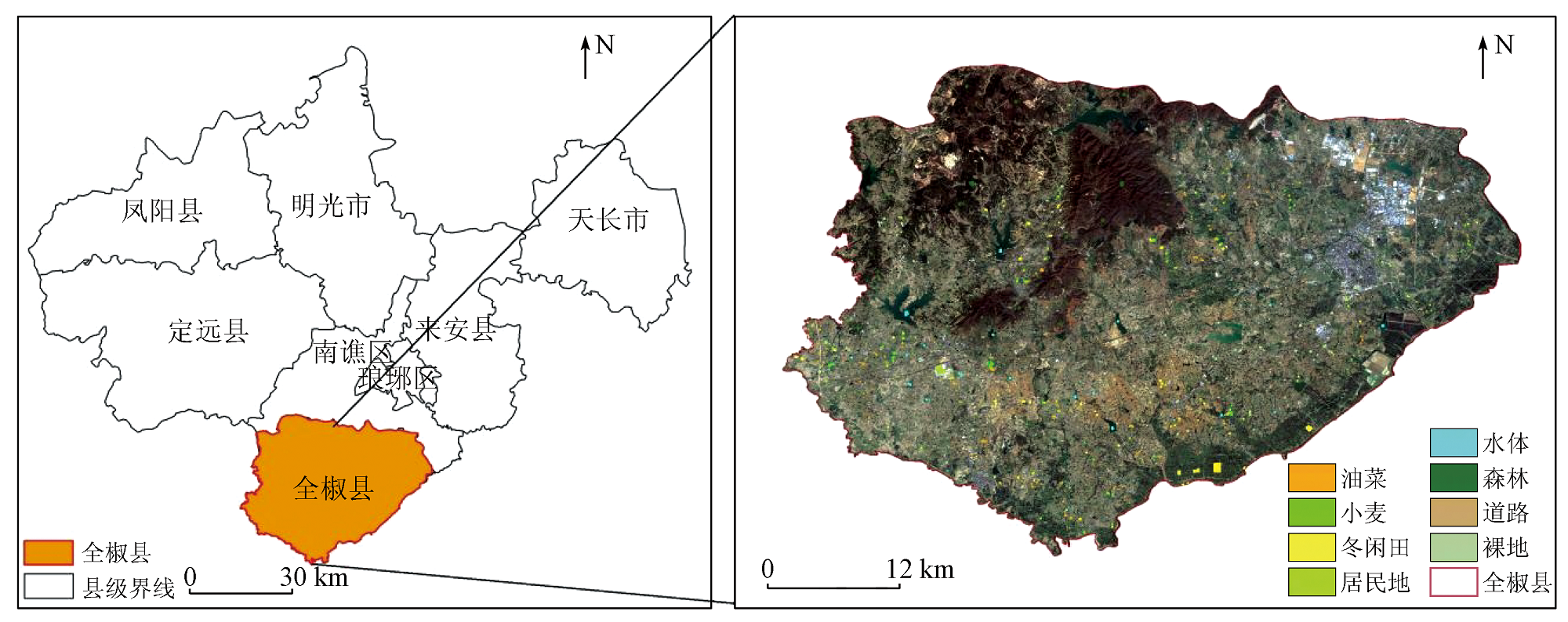
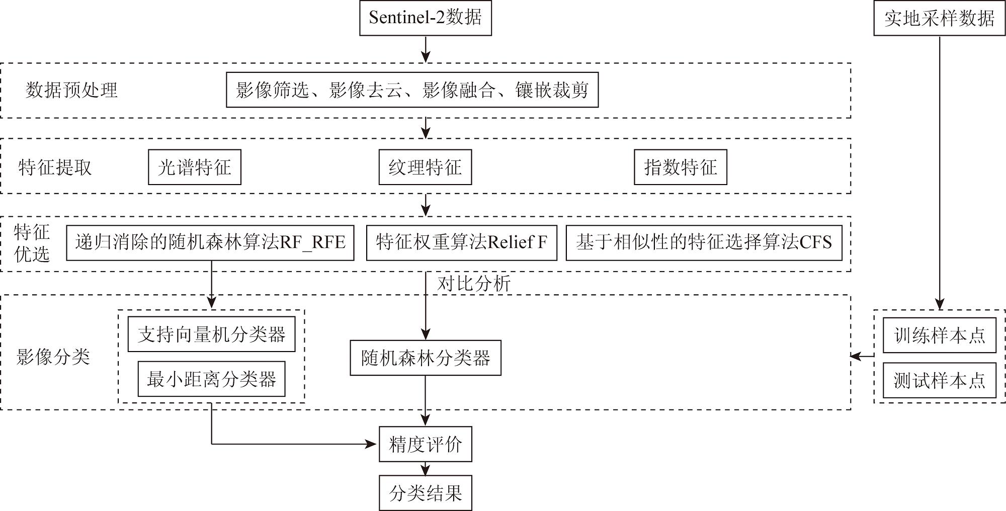
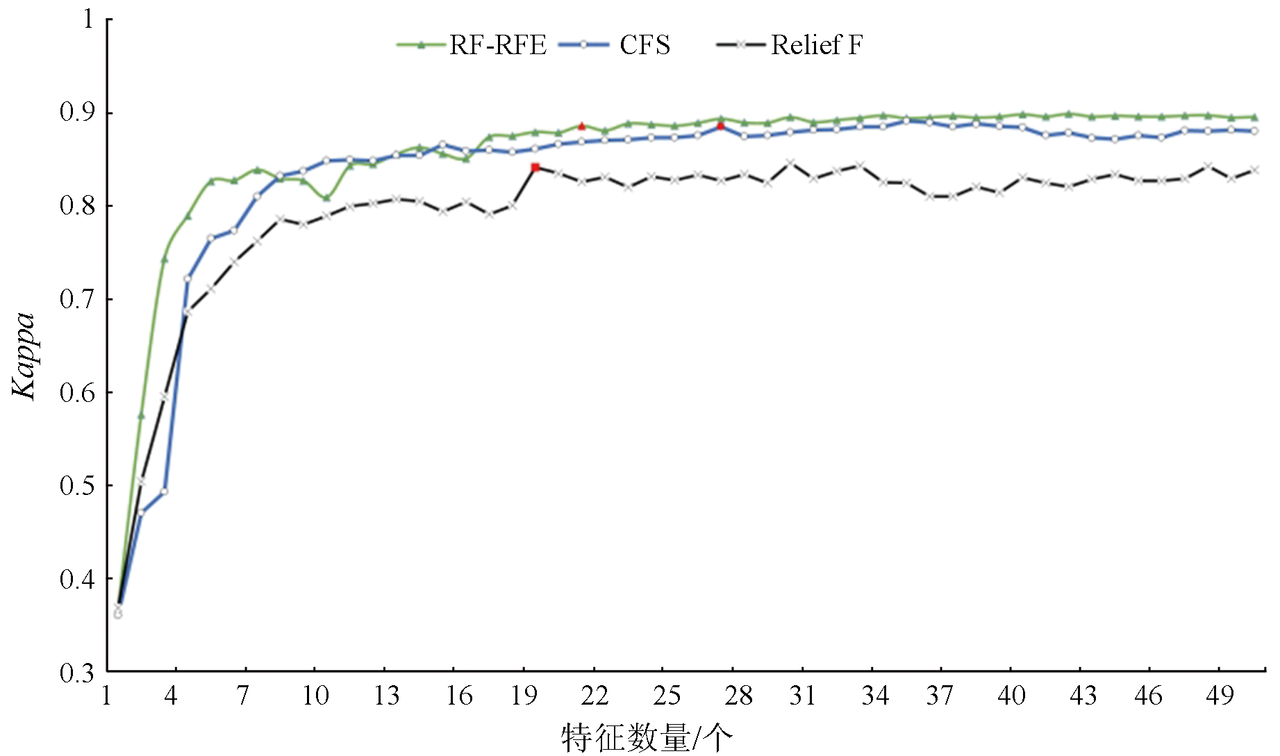
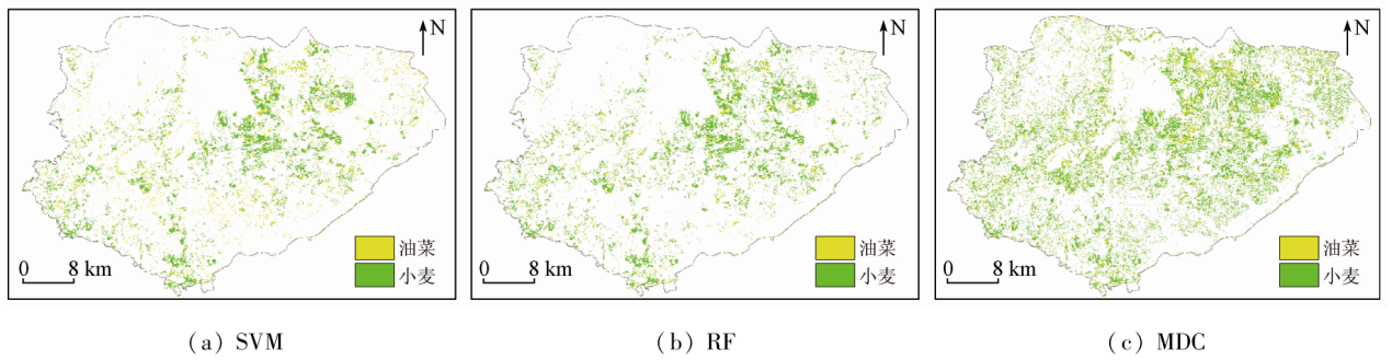
Focusing on Quanjiao County in Chuzhou City, this study determined 90 features, including spectral, traditional vegetation index, red-edge vegetation index, and texture features, from Sentinel-2 satellite data on the GEE platform. This study examined the effects of diverse feature optimization algorithms combined with a random forest classifier on identifying crop planting types in the study area. These algorithms included the random forest-recursive feature elimination (RF_RFE) algorithm, the Relief F algorithm based on Relief expansion, and the correlation-based feature selection (CFS) algorithm. On this basis, this study further analyzed the classification effects of the optimal feature optimization algorithm in various machine learning classification approaches. The study demonstrates that: ① Spectral features proved to be the most crucial for crop identification, followed by red-edge index features, and texture features manifested minimal effects; ② RF_RFE-based remote sensing identification results exhibited the highest accuracy, with overall accuracy of 92% and a Kappa coefficient of 0.89; ③ Under the RF_RFE feature optimization method, the RF’s Kappa coefficient was 0.01 and 0.41 higher than that of the support vector machine (SVM) and the minimum distance classification (MDC), respectively. This indicates that the RF_RFE feature optimization method based on multiple features, combined with the RF algorithm, can effectively enhance the accuracy and efficiency of remote sensing identification of crops.
陈健, 李虎, 刘玉锋, 常竹, 韩伟杰, 刘赛赛. 基于Sentinel-2数据多特征优选的农作物遥感识别研究[J]. 自然资源遥感, 2023, 35(4): 292-300.
CHEN Jian, LI Hu, LIU Yufeng, CHANG Zhu, HAN Weijie, LIU Saisai. Crops identification based on Sentinel-2 data with multi-feature optimization. Remote Sensing for Natural Resources, 2023, 35(4): 292-300.
Huang J X, Wu S J, Liu X Q, et al. Regional winter wheat yield forecasting based on assimilation of remote sensing data and crop growth model with Ensemble Kalman method[J]. Transactions of the Chinese Society of Agricultural Engineeing, 2012, 28(4):142-148.
Wang L M, Liu J, Ji F H. Application status and development trend of agriculture remote sensing technology application in China[J]. Chinese Agricultural Science Bulletin, 2021, 37(25):138-143.
Cheng B. Land use information extraction based on support vector machine using multitemporal remote sensing in Qian’an County[J]. Journal of Changchun Normal University, 2017, 36(12):86-88.
Wang D J, Jiang Q G, Li Y H, et al. Land use classification of farming areas based on time series Sentinel-2A/B data and random forest algorithm[J]. Remote Sensing of Land and Resources, 2020, 32(4):236-243.doi:10.6046/gtzyyg.2020.04.29.
Yang H, Deng F, Zhang J H, et al. A study of information extraction of rape and winter wheat planting in Jianghan Plain based on MODIS EVI[J]. Remote Sensing of Land and Resources, 2020, 32(3):208-215.doi:10.6046/gtzyyg.2020.03.27.
Liang J, Zheng Z W, Xia S T, et al. Crop recognition and evaluationusing red edge features of GF-6 satellite[J]. Journal of Remote Sensing, 2020, 24(10):1168-1179.
Zhou X C, Zheng L, Huang H Y. Classification of forest stand based on multi-feature optimization of UAV visible light remote sensing[J]. Forestry Science, 2021, 57(6):24-36.
Liu J F, Li L F, Ren C Y, et al. Information extraction of coastal wetlands in Yellow River Estuary by optimal feature-based random forest model[J]. Journal of Wetland Science, 2018, 16(2):97-105.
Liu Y, Meng Q Y, Wang Y J, et al. A method for estimating impervious surface percentage based on feature optimization and SVM[J]. Geography and Geoinformatics Science, 2018, 34(1):24-31,3.
Zhang D Y, Yang Y Y, Huang L S, et al. Extraction of soybean planting areas combining Sentinel-2 images and optimized feature model[J]. Transactions of the Chinese Society of Agricultural Engineering, 2021, 37(9):110-119.
Zhang W B, Kong J L, Yang Y Y, et al. Fine vegetation classification of remote sensing in arid areas based on object-oriented method[J]. Science of Surveying and Mapping, 2021, 46(1):136-140,183.
[13]
Ni R, Tian J, Li X, et al. An enhanced pixel-based phenological feature for accurate paddy rice mapping with Sentinel-2 imagery in Google Earth Engine[J]. ISPRS Journal of Photogrammetry and Remote Sensing, 2021,178,282-296.
Wang L J, Kong Y R, Yang X D, et al. Classification of land use in farming areas based on feature optimization random forest algorithm[J]. Transactions of the Chinese Society of Agricultural Engineering, 2020, 36(4):244-250.
Xiong H L, Zhou X C, Wang X Q, et al. Mapping the spatial distribution of tea plantations with 10 m resolution in Fujian Province using google earth engine[J]. Journal of Geoinformatics Science, 2021, 23(7):1325-1337.
Zhang L, Gong Z N, Wang Q W, et al. Wetland mapping of Yellow River Delta wetlands based on multi-feature optimization of Sentinel-2 images[J]. Journal of Remote Sensing, 2019, 23(2):313-326.
[17]
Haralick R M, Shanmugam K, Dinstiein I H. Textural features for image classification[J]. IEEE Transactions on Systems,Man,and Cybernetics, 1973, 3(6):610-621.
Wang G Z, Jin H L, Gu X H, et al. Remote sensing classification of autumn crops based on hybrid feature selection model combining with relief F and improved separability and thresholds[J]. Transactions of the Chinese Society for Agricultural Machinery, 2021, 52(2):199-210.
Gao G L, Du H Q, Han N, et al. Mapping of moso bamboo forest using object-based approach based on the optimal features[J]. Forestry Sciences, 2016, 52(9):77-85.
[20]
Millard K, Richardson M. On the importance of training data sample selection in random forest image classification:A case study in peatland ecosystem mapping[J]. Remote Sensing, 2015, 7(7):8489-8515.
doi: 10.3390/rs70708489
 2023, Vol. 35
  ), 李虎1,3, 刘玉锋2(