Analysis of Ningyuan Estuary coastline transition based on the multi-resource remote sensing image
Kun LUO1, Bo DING2,3(), Genyuan LONG1
1. Marine Geological Survey Institute of Hainan Province, Haikou 570206, China 2. School of Earth Science, China University of Geosciences(Wuhan), Wuhan 430074, China 3. Hainan Comprehensive Design Institute of Geological Survey, Haikou 570206, China
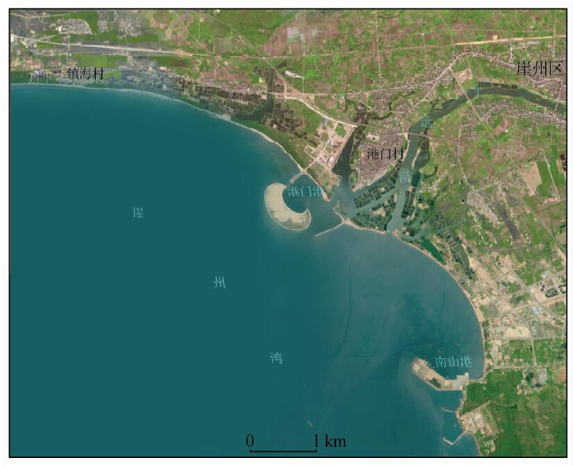
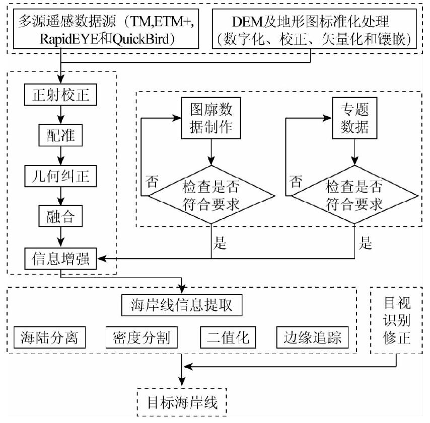
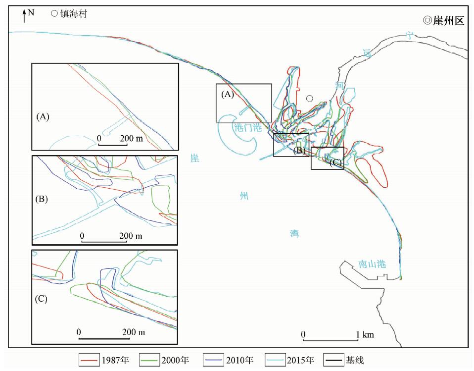
In this paper, by utilizing 4 phases of multi-resource remote sensing images in 1987, 2000, 2010 and 2015, the authors carried out the information extraction of coastline in Ningyuan Estuary in 4 phases from 1987 to 2015,and analyzed spatial and temporal characteristics,influencing factors and development trend of coastline transition by using the density segmentation and binarization processing based on object-oriented information extraction technology. Some conclusions have been reached: The coastline of Ningyuan Estuary overall showed a trend of growth from 1987 to 2015, with the total length increasing up to 8.14 km. The ecological environment of the coastal zone in Ningyuan Estuary has changed greatly with the disappearance of mangrove resources near the estuary largely, the expansion of artificial breeding zones and the continuous deterioration of water quality. The overall feature in the delta of Ningyuan Estuary is siltation, and that in the west of the estuary is erosion. The major influencing factors include coastal erosion and siltation, artificial breeding in the tideland and the construction of the artificial island as well as the building of a dam for sand control. The situation of Ningyuan Estuary is not optimistic in recent years. The erosion of the artificial island’s west coastline tends to become worse and the coastal siltation will be further intensified in the east of the sand-protecting dam.
罗昆, 丁波, 龙根元. 基于多源遥感影像的宁远河口海岸线变迁分析[J]. 国土资源遥感, 2018, 30(4): 187-192.
Kun LUO, Bo DING, Genyuan LONG. Analysis of Ningyuan Estuary coastline transition based on the multi-resource remote sensing image. Remote Sensing for Land & Resources, 2018, 30(4): 187-192.
Yang L, Li J L, Yuan Q X , et al. Spatial-temporal changes of continental coastline in southern China[J]. Journal of Marine Sciences, 2014,32(3):42-49.
Zhao Y L . Remote sensing survey and proposal for protection of the shoreline and the mangrove wetland in Guangdong Province[J]. Remote Sensing for Land and Resources, 2017,29(s1):114-120.doi: 10.6046/gtzyyg.2017.s1.19.
Zhao Y L . Remote sensing dynamic monitoring of the shoreline and the mangrove wetland in the Lingdingyang Estuary in the past 40 years[J]. Remote Sensing for Land and Resources, 2017,29(1):136-142.doi: 10.6046/gtzyyg.2017.01.21.
Wang J N, Meng Y H, Zhang L X . Remote sensing monitoring and change analysis of Yellow River Estuary coastline in the past 42 years[J]. Remote Sensing for Land and Resources, 2017,28(3):188-193.doi: 10.6046/gtzyyg.2016.03.29.
Yang C K, Liu Z Q, Wang C C , et al. Spatial change analysis of the coastal zone of Liaodong Bay from 2001 to 2013[J] Remote Sensing for Land and Resources, 2015,27(4):150-157.doi: 10.6046/gtzyyg.2015.04.23.
[6]
Solomon S M . Spatial and temporal variability of shoreline change in the Beaufort-Mackenzie region,northwest territories[J]. Geo-Marine Letters, 2005,25(2-3):127-137.
doi: 10.1007/s00367-004-0194-x
[7]
Sheik M , Chandrasekar.Ashoreline change analysis along the coast between Kanyakumari and Tuticorin,India,using digital shoreline analysis system[J]. Geo-spatial Information Science, 2011,14(4):282-293.
doi: 10.1007/s11806-011-0551-7
Zhu J F, Wang G M, Zhang J L , et al. Remote sensing investigation and recent evolution analysis of Pearl River Delta coastline[J]. Remote Sensing for Land and Resources, 2013,25(3):130-137.doi: 10.6046/gtzyyg.2013.03.22.
Liu Y, Huang H J, Yan L W . Remote sensing applications in extraction of Shijiutuo Island coastline based on different spatial scales[J]. Remote Sensing Technology and Application, 2013,28(1):144-149.
[10]
Dellepiane S, Laurentiis R D, Giordano F . Coastline extraction from SAR images and a method for the evaluation of the coastline precision[J]. Pattern Recognition Letters, 2004,25(13):1461-1470.
doi: 10.1016/j.patrec.2004.05.022
Yan H B, Li B B, Chen M D . Progress of researches in coastline extraction based on RS technique[J]. Areal Research and Development, 2009,28(1):101-105.
Du T, Zhang B . A study of mapping coast by progressing remote sensing image with wavelets[J]. Marine Sciences, 1999,04:19-21.
[13]
Liu H X, Wang L, Douglas J S , et al. Algorithmic foundation and software tools for extracting shoreline features from remote sensing imagery and LiDAR data[J]. Journal of Geographic Information System, 2011,3(2):99-119.
doi: 10.4236/jgis.2011.32007
Feng Y J, Yuan J Y, Song L J , et al. Coastline mapping and change detection along Hangzhou Bay using remotely sensed imagery[J] . Remote Sensing Technology and Application, 2015,30(2):345-352.
Yu J, Chen G B, Huang Z R , et al. Changes in the coastline of three typical bays in Guangdong during recent 10 years revealed by satellite image[J]. Transaction of Oceanology and Limnology, 2014,3:91-96.
 2018, Vol. 30
  ), 龙根元1