The extraction and analysis of Luding earthquake-induced landslide based on high-resolution optical satellite images
ZHANG Yu1(), MING Dongping1(), ZHAO Wenyi1,2, XU Lu1, ZHAO Zhi1, LIU Ran1
1. School of Information Engineering, China University of Geosciences (Beijing), Beijing 100083, China 2. China Geological Environment Monitoring Institute, Beijing 100081, China
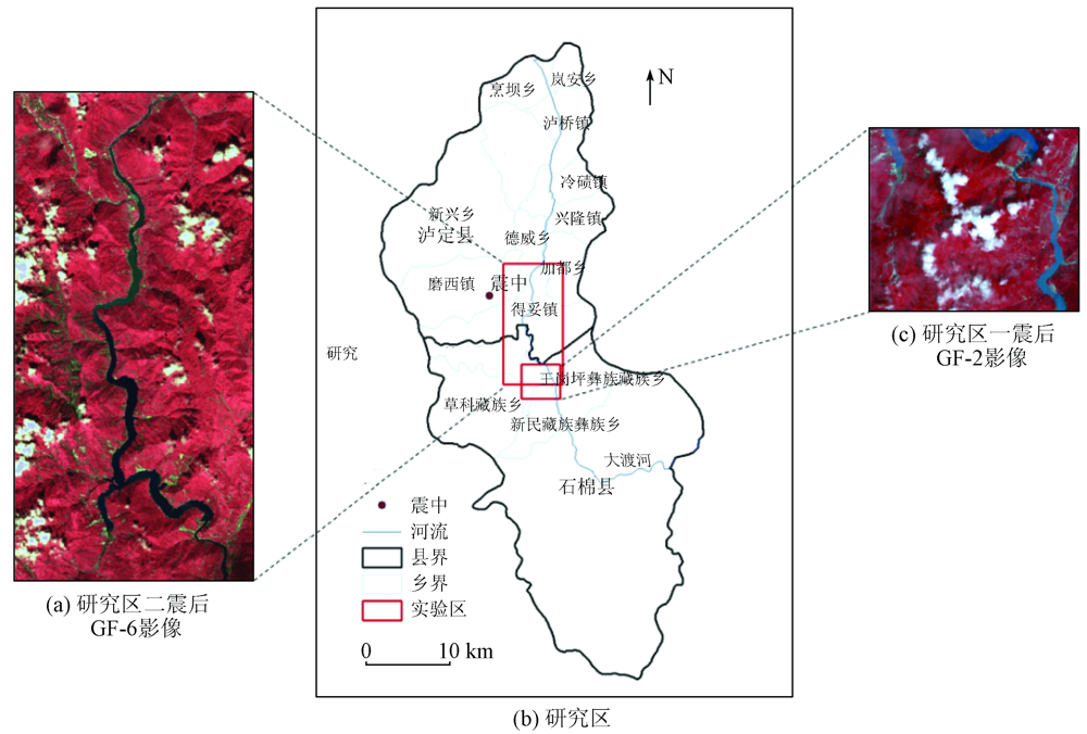
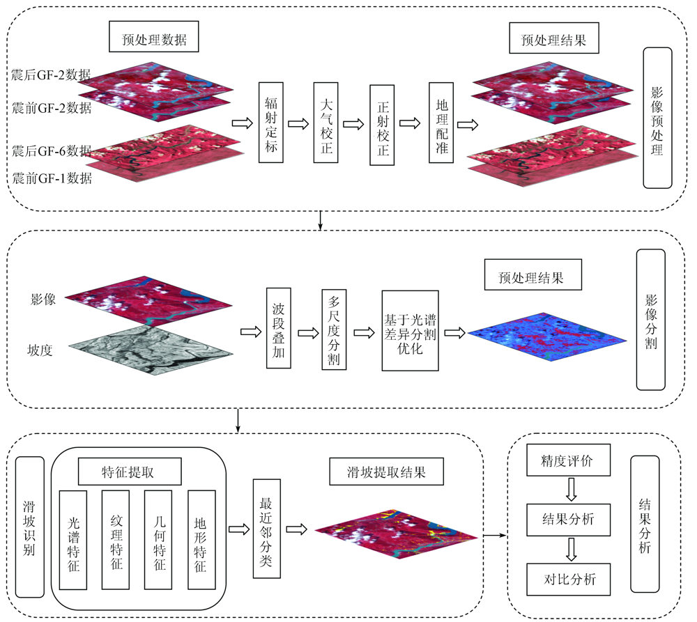
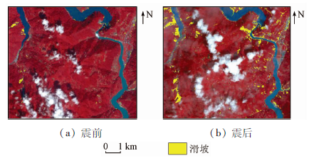
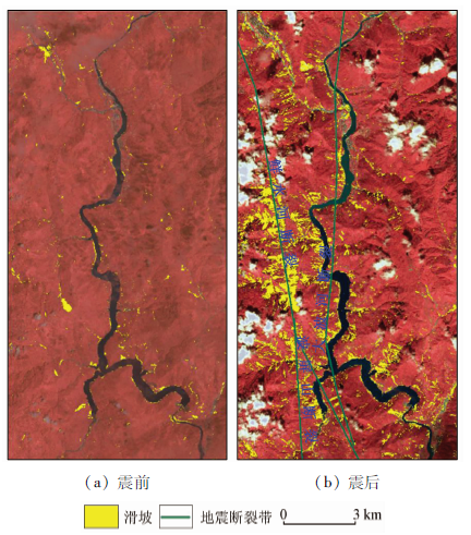
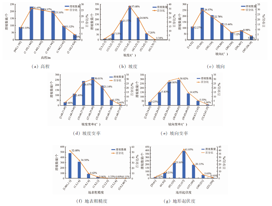
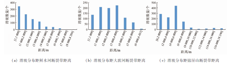
On September 5, 2022, a Ms 6.8 earthquake occurred in Luding County, Ganzi Prefecture, Sichuan Province, inducing numerous landslides. This study collected the pre- and post-earthquake images from the GF-2 and GF-6 satellites, as well as the DEM data of Luding. Then, using the object-oriented method, the stepwise optimization multi-scale segmentation method, and the nearest neighbor classification method, this study extracted the landslide information according to the spectrum, thematic index, geometric texture, and topographic features of the objects in the experimental area. The overall identification accuracy of pre- and post-earthquake landslides was 92.3% and 95.4%, respectively. The comprehensive analysis of the distribution of pre- and post-earthquake landslide landslides shows that 23.91 km2 of new landslides were induced by the earthquake. This study summarized the distribution characteristics of post-earthquake landslides through the spatial statistical analysis of seven topographic factors. The results are as follows: ① The post-earthquake landslides were mainly affected by the Xianshuihe fault zone, and they show a banded distribution along rivers and a lamellar, dense distribution along the hillsides and valleys near the fault zone; ② Compared with the historical landslides, the new landslides have a relatively stable elevation range and a large slope range. Moreover, there is a significantly negative correlation between the area of the post-earthquake landslides and the surface roughness.
Li Q, Zhang J F, Luo Y, et al. Recognition of earthquake-induced landslide and spatial distribution patterns triggered by the Jiuzhaigou earthquake in August 8,2017[J]. Journal of Remote Sensing, 2019, 23(4):785-789.
Su F H, Liu H J, Han Y S. The extraction of mountain hazard induced by Wenchuan earthquake and analysis of its distributing characteristic[J]. Journal of Remote Sensing, 2008(6):956-963.
[3]
Nichol J, Wong M S. Satellite remote sensing for detailed landslide inventories using change detection and image fusion[J]. International Journal of Remote Sensing, 2005, 26(9):1913-1926.
doi: 10.1080/01431160512331314047
Gu H Y, Li H T, Yan L. A geographic object-based image analysis methodology based on geo-ontology[J]. Geomatics and Information Science of Wuhan University, 2018, 43(1):31-36.
Liu C, Liu X G, Chen Q H, et al. Impact of DEM spatial resolution on landslide extraction using object-oriented methods[J]. Remote Sensing Technology and Application, 2014(4):631-638.
Zhang Q, Zhao C Y. Semiautomatic object-oriented loose landslide recognition based on high resolution remote sensing images in Heifangtai,Gansu[J]. Journal of Catastrophology, 2017, 32(3):210-215.
Ding Y H, Zhang Q, Yang C S, et al. Landslide identification in Jinsha River basin based on high-resolution remote sensing:Taking Wangdalong Village of Batang County as an example[J]. Bulletin of Surveying and Mapping, 2022,(4):51-55.
Peng L, Xu S N, Mei J J, et al. Earthquake-induced landslide recognition using high-resolution remote sensing images[J]. Journal of Remote Sensing, 2017, 21(4):509-518.
Tang Y. Emergency monitoring of high-level landslide disasters in Jinsha River using domestic remote sensing satellites[J]. Journal of Remote Sensing, 2019, 23(2):252-261.
[11]
Han Y, Wang P, Zheng Y, et al. Extraction of landslide information based on object-oriented approach and cause analysis in Shuicheng,China[J]. Remote Sensing, 2022, 14(3):502.
doi: 10.3390/rs14030502
[12]
Tavakkoli P S, Shahabi H, Jarihani B, et al. Landslide detection using multi-scale image segmentation and different machine learning models in the higher himalayas[J]. Remote Sensing, 2019, 11(21):2575.
doi: 10.3390/rs11212575
[13]
Barlow J, Martin Y, Franklin S E. Detecting translational landslide scars using segmentation of Landsat ETM+ and DEM data in the northern Cascade Mountains,British Columbia[J]. Canadian Journal of Remote Sensing, 2003, 29(4):510-517.
doi: 10.5589/m03-018
[14]
Martha T R K N, Jetten V. Characterising spectral,spatial and morphometric properties of landslides for semi-automatic detection using object-oriented methods[J]. Geomorphology, 2010, 116(1-2):24-36.
doi: 10.1016/j.geomorph.2009.10.004
Lin Q G. Object-oriented detection of landslides based on the spectral,spatial and morphometric properties of landslides[J]. Remote Sensing Technology and Application, 2017, 32(5):931-937.
[16]
Ji S, Yu D, Shen C, et al. Landslide detection from an open satellite imagery and digital elevation model dataset using attention boosted convolutional neural networks[J]. Landslides, 2020, 17(6):1337-1352.
doi: 10.1007/s10346-020-01353-2
[17]
Sameen M I, Pradhan B. Landslide detection using residual networks and the fusion of spectral and topographic information[J]. IEEE Access, 2019, 7:114363-114373.
doi: 10.1109/Access.6287639
[18]
Cai H, Chen T, Niu R, et al. Landslide detection using densely connected convolutional networks and environmental conditions[J]. IEEE Journal of Selected Topics in Applied Earth Observations and Remote Sensing, 2021, 14:5235-5247.
doi: 10.1109/JSTARS.2021.3079196
[19]
Bragagnolo L, Rezende L R, Dasilva R V, et al. Convolutional neural networks applied to semantic segmentation of landslide scars[J]. Catena, 2021, 201:105189.
doi: 10.1016/j.catena.2021.105189
[20]
Prakash N, Manconi A, Loew S. Mapping landslides on EO data:performance of deep learning models vs.traditional machine learning models[J]. Remote Sensing, 2020, 12(3):346.
doi: 10.3390/rs12030346
[21]
Liu T, Chen T, Niu R, et al. Landslide detection mapping employing CNN,ResNet,and DenseNet in the Three Gorges Reservoir,China[J]. IEEE Journal of Selected Topics in Applied Earth Observations and Remote Sensing, 2021, 14:11417-11428.
doi: 10.1109/JSTARS.2021.3117975
Wang X, Fang C Y, Tang X C, et al. Research on emergency evaluation of landslides induced by Luding Ms 6.8 earthquake[J]. Geomatics and Information Science of Wuhan University, 2023, 48(1):25-35.
[23]
陈扬洋. 基于对地观测数据的滑坡灾害解译与分析[D]. 北京: 中国地质大学(北京), 2022.
Chen Y Y. Interpretation and analysis of landslide hazard based on earth observation data[D]. Beijing: China University of Geosciences (Beijing), 2022.
[24]
Liu P, Wei Y, Wang Q, et al. Research on post-earthquake landslide extraction algorithm based on improved U-Net model[J]. Remote Sensing, 2020, 12(5):894.
doi: 10.3390/rs12050894
[25]
Liu P, Wei Y, Wang Q, et al. A research on landslides automatic extraction model based on the improved mask R-CNN[J]. ISPRS International Journal of Geo-Information, 2021, 10(3):168.
doi: 10.3390/ijgi10030168
[26]
Shi W, Zhang M, Ke H, et al. Landslide recognition by deep convolutional neural network and change detection[J]. IEEE Transactions on Geoscience and Remote Sensing, 2021, 59(6):4654-4672.
doi: 10.1109/TGRS.2020.3015826
Wang Y S, Cheng W Q, Liu J W. Forming process and mechanisms of geo-hazards in Luding section of the Sichuan-Tibet railway[J]. Earth Science, 2022, 47(3):950-958.
[28]
黄志坚. 面向对象影像分析中的多尺度方法研究[D]. 长沙: 国防科学技术大学, 2014.
Huang Z J. Research on multiscale methods in object-based image analysis[D]. Changsha: National University of Defence Technology, 2014.
Xiong H W, Yu C S, Li X Y, et al. Rapid extraction of impervious surface information based on high-resolution remote sensing images[J]. Territory and Natural Resources Study, 2015, 1:52-54.
[31]
Ming D, Li J, Wang J, et al. Scale parameter selection by spatial statistics for GEOBIA:Using mean-shift based multi-scale segmentation as an example[J]. ISPRS Journal of Photogrammetry and Remote Sensing, 2015, 106:28-41.
doi: 10.1016/j.isprsjprs.2015.04.010
Fan L, Zhang Q. Occurrence and distribution characteristics of landslides at Suwalong-Benzilan along Jinsha River[J]. Journal of Yangtze River Scientific Research Institute, 2016, 33(3):38-41.
[33]
Dragut L, Csillik O, Eisank C, et al. Automated parameterisation for multi-scale image segmentation on multiple layers[J]. ISPRS Journal of Photogrammetry and Remote Sensing, 2014, 88:119-127.
doi: 10.1016/j.isprsjprs.2013.11.018
[34]
Dragut L, Tiede D, Levick S R. ESP:A tool to estimate scale parameter for multiresolution image segmentation of remotely sensed data[J]. International Journal of Geographical Information Science, 2010, 24(6):859-871.
doi: 10.1080/13658810903174803
Huang T, Bai X F, Zhuang Q F, et al. Research on landslides extraction based on the Wenchuan earthquake in GF-1 remote sensing image[J]. Bulletin of Surveying and Mapping, 2018,(2):67-71,82.
Chen X L, Liu C G, Chuan Y J, et al. Study on the distribution of co-seismic landslides and terrain features in the Ms 6.5 Ludian earthquake affected area[J]. Seismology and Geology, 2021, 43(1):92-104.
[37]
Chigira M, Yagi H. Geological and geomorphological characteristics of landslides triggered by the 2004 Mid Niigta prefecture earthquake in Japan[J]. Engineering Geology, 2006, 82(4):202-221.
doi: 10.1016/j.enggeo.2005.10.006
Tie Y B, Zhang X Z, Lu J Y, et al. Characteristics of geological hazards and it’s mitigations of the Ms 6.8 earthquake in Luding County,Sichuan Province[J]. Hydrogeology & Engineering Geology, 2022, 49(6):1-12.
 2023, Vol. 35
  ), 明冬萍1(