Derivation of tasseled cap transformation coefficients for GF-6 WFV sensor data
ZHANG Haojie1(), YANG Lijuan1,2, SHI Tingting2,3, WANG Shuai1()
1. School of Geography and Oceanography, Minjiang University, Fuzhou 350108, China 2. Institute of Remote Sensing Information Engineering, Fuzhou University, Fuzhou 350108, China 3. School of Economics and Management of Minjiang University, Fuzhou 350108, China
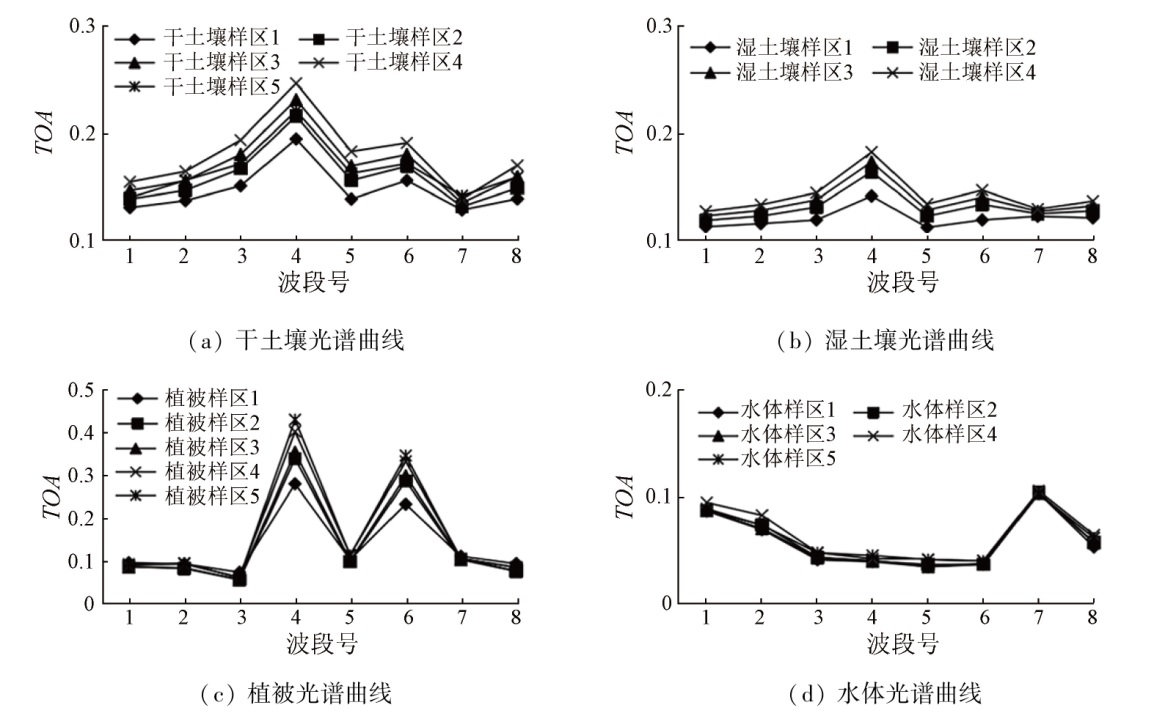
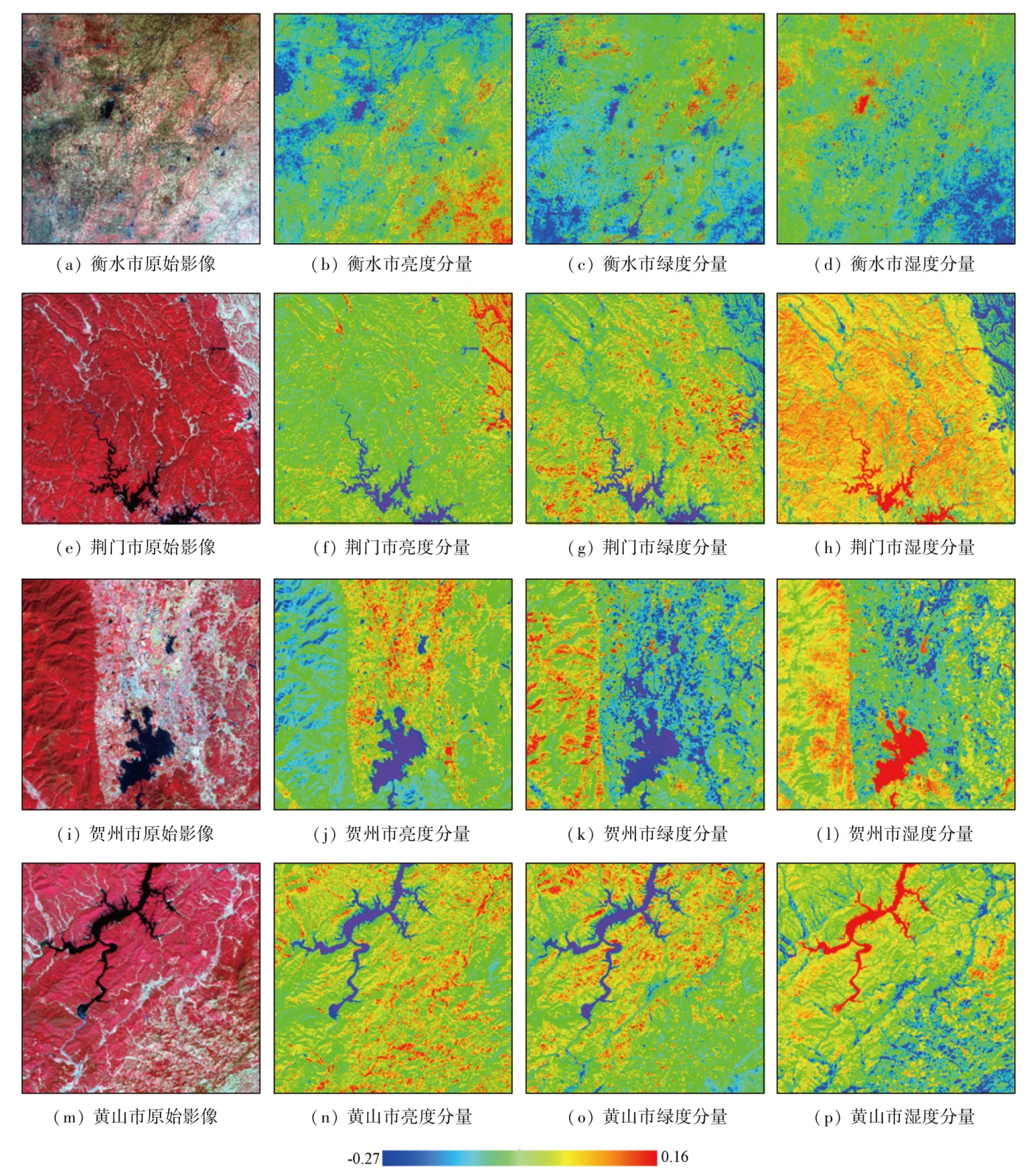
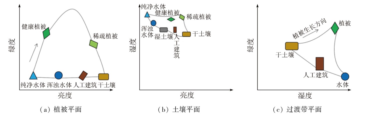
Tasseled cap transformation (TCT), one of the most common methods in image enhancement, has been extensively applied in remote sensing. However, high-resolution satellite sensors (like GF-6 WFV) usually lack short-wave infrared bands, leading to distorted wetness components in TCT coefficients obtained using the conventional Gram-Schmidt (G-S) orthogonalization method. Hence, this study selected 12 GF-6 WFV images covering different regions, temporal phases, and seasons, as well as six synchronous Landsat8 images for wetness component regression, determining the wetness component coefficient of the GF-6 WFV sensor. Furthermore, it employed the inversed G-S algorithm to deduce the brightness, greenness, and other components, deriving the TCT coefficient of the GF-6 WFV sensor. This study found that: ①Adjusting the derivation order of the wetness component in TCT (that is, the derivation of the wetness component comes before that of other components like brightness and greenness) allows more effective derivation of the TCT coefficient of the GF-6 WFV sensor, avoiding the distortion of the wetness component; ②The TCT components of the GF-6 WFV sensor exhibited stable characteristics, with surface features displaying a typical “tasseled cap” distribution in the feature plane composed by various TCT components; ③Despite the differences in band setting and spectral response, GF-6 WFV and Landsat8 OLI sensors manifested high consistency in corresponding TCT components, with a correlation coefficient of up to 0.8.
Chen C, Jiang T, Liu X L. Research on remote sensing image fusion methods based on tasseled cap transformation[J]. Science of Surveying and Mapping, 2009, 34(3):105-106,163.
Chen C, He X Y, Fu J Q, et al. A method of flood submerging area extraction for farmland based on tasseled cap transformation from remote sensing images[J]. Geomatics and Information Science of Wuhan University, 2019, 44(10):1560-1566.
Wang S, Xu H Q, Shi T T. Retrieval of tasseled cap transformation coefficients for GF-1 WFV2 sensor data[J]. Advances in Earth Science, 2018, 33(6):641-652.
doi: 10.11867/j.issn.1001-8166.2018.06.0641
[5]
Kauth R J, Thomas G S. The tasselled cap:A graphic description of the spectral-temporal development of agricultural crops as seen by Landsat[C]// LARS Symposia, 1976:159.
[6]
Crist E P, Cicone R C. Application of the tasseled cap concept to simulated thematic mapper data[J]. Photogrammetric Engineering & Remote Sensing, 1984, 50(3):343-352.
[7]
Huang C, Wylie B, Yang L, et al. Derivation of a tasselled cap transformation based on Landsat 7 at-satellite reflectance[J]. International Journal of Remote Sensing, 2002, 23(8):1741-1748.
[8]
Baig M H A, Zhang L, Shuai T, et al. Derivation of a tasselled cap transformation based on Landsat 8 at-satellite reflectance[J]. Remote Sensing Letters, 2014, 5(5):423-431.
[9]
Liu Q, Liu G, Huang C, et al. A tasseled cap transformation for Landsat 8 OLI TOA reflectance images[C]// Geoscience and Remote Sensing Symposium.IEEE, 2014:541-544.
[10]
Liu Q, Liu G, Huang C, et al. Comparison of tasselled cap transformations based on the selective bands of Landsat8 OLI TOA reflectance images[J]. International Journal of Remote Sensing, 2015, 36(2):417-441.
Li B L, Ti C P, Yan X Y. Study of derivation of tasseled cap transformation for Landsat8 OLI images[J]. Science of Surveying and Mapping, 2016, 41(4):102-107.
[12]
Yarbrough L D, Easson G, Kuszmaul J. QuickBird 2 tasseled cap transform coefficients:A comparison of derivation methods[C]// Pecora 16 Global Priorites in Land Remote Sensing,Sioux Falls,South Pakota, 2005, 16:23-27.
[13]
Verdin J, Eckhardt D, Lyford G. Evaluation of SPOT imagery for monitoring irrigated lands[C]// Proceedings International Conference on SPOT 1 Image Utilization,Assessment,Results p81-91 (SEEN88-2834622-43),Paris, 1987,
[14]
Silva D A. Determination of ‘tasseled cap’ transformation parameters for images obtained by the SPOT satellite[C]// International Symposium on Remote Sensing of Environment,24th,Rio de Janeiro,Brazil, 1992:291-300.
[15]
Lobser S E, Cohen W B. MODIS tasselled cap:Land cover characteristics expressed through transformed MODIS data[J]. International Journal of Remote Sensing, 2007, 28(22):5079-5101.
[16]
Sheng L, Huang J F, Tang X L. A tasseled cap transformation for CBERS-02B CCD data[J]. Journal of Zhejiang University (Science B), 2011, 12(9):780-786.
[17]
Chen C,Tang, Bian Z. Tasseled cap transformation for HJ-1A/B charge coupled device images[J]. Journal of Applied Remote Sensing, 2012, 6(1):063575.
Shi T T, Xu H Q, Wang S. Derivation of tasselled cap transformation coefficients for ZY-3 MUX sensor data[J]. Journal of Remote Sensing, 2019, 23(3):514-525.
[19]
Chander G, Markham B L, Helder D L. Summary of current radiometric calibration coefficients for Landsat MSS,TM,ETM+,and EO-1 ALI sensors[J]. Remote Sensing of Environment, 2009, 113(5):893-903.
[20]
Crist E P, Kauth R J. The tasseled cap de-mystified[J]. Photogrammetric Engineering and Remote Sensing, 1986,52.
[21]
Richardson A J, Wiegand C L. Distinguishing vegetation from soil background information[J]. Photogrammetric Engineering and Remote Sensing, 1977, 43:1541-1552.
[22]
Jackson R D. Spectral indices in N-Space[J]. Remote Sensing of Environment, 1983, 13(5):409-421.
[23]
Horne J H. A tasseled cap transformation for IKONOS images[C]// ASPRS 2003 Annual Conference Proceedings.ASPRS, 2003.
 2024, Vol. 36
  ), 杨立娟1,2, 施婷婷2,3, 王帅1(