Mapping mountain vegetation using realistic 3D models integrating optical images and light detection and ranging data
ZHANG Jinhua1,2,3(), HU Zhongwen1,2,3(), ZHANG Yinghui1,2,3, ZHANG Qian1,2,3, WANG Jingzhe1,4, WU Guofeng1,2,3
1. MNR Key Laboratory for Geo-Environmental Monitoring of Great Bay Area, Shenzhen University, Shenzhen 518060, China 2. Guangdong Key Laboratory of Urban Informatics, Shenzhen University, Shenzhen 518060, China 3. School of Architecture and Urban Planning, Shenzhen University, Shenzhen 518060, China 4. School of Artificial Intelligence, Shenzhen Polytechnic University, Shenzhen 518060, China
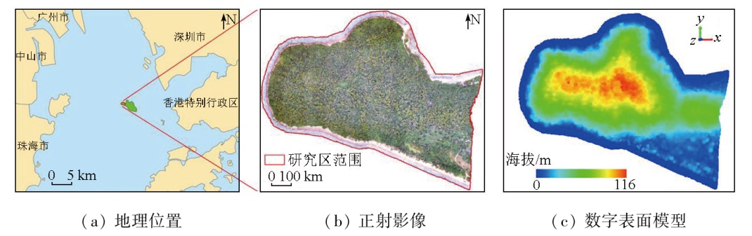
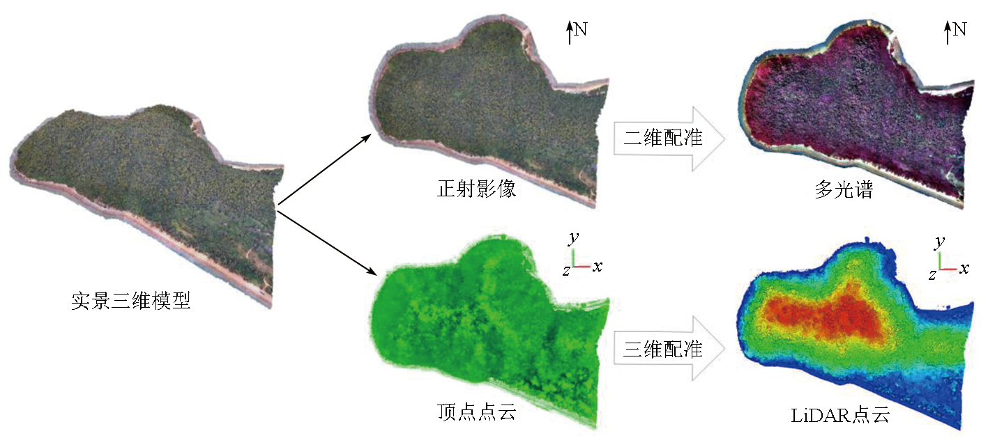
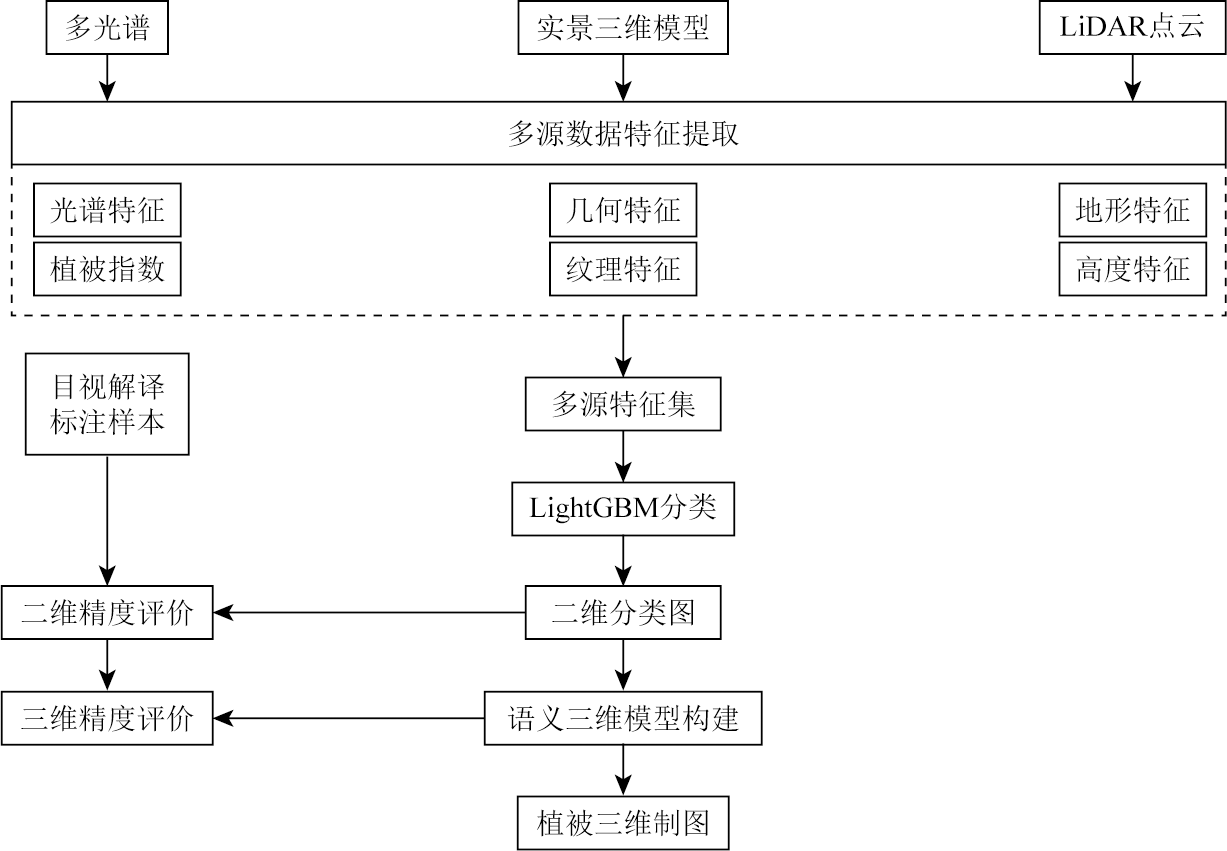
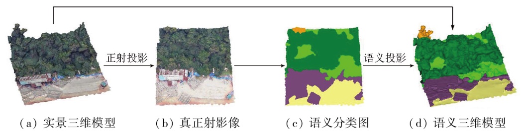
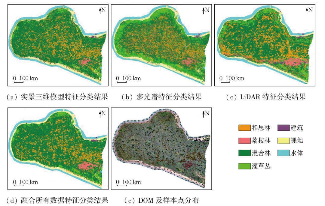
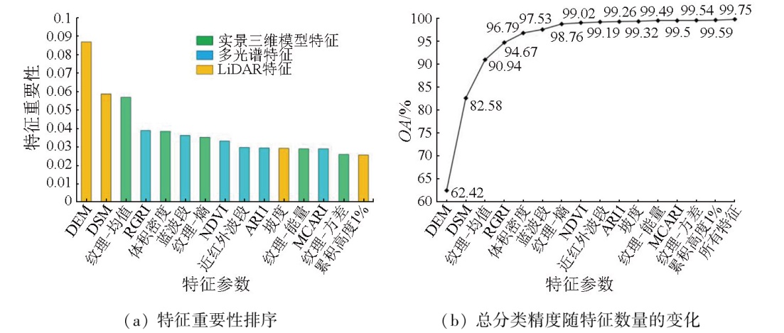
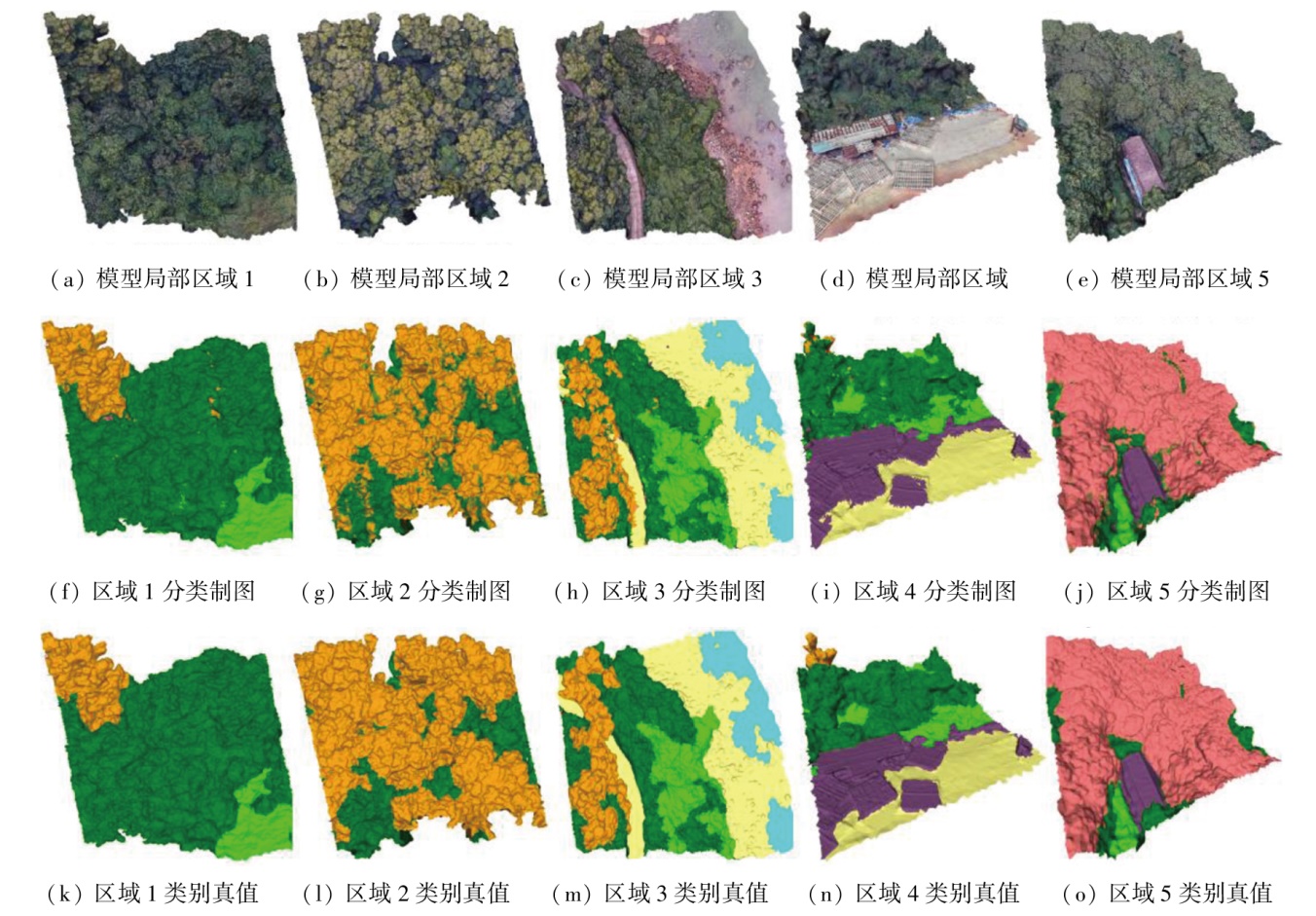
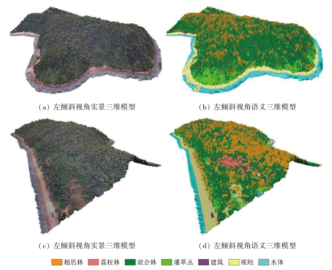
Vegetation distribution serves as a crucial foundation for natural resource conservation and ecosystem health assessment. In mountainous regions, substantial terrain undulations and complex vegetation types complicate the mapping process. Moreover, the traditional remote sensing-based vegetation classification, whose mapping relies on 2D imagery, fails to depict the vertical structure and 3D spatial distribution of vegetation. To investigate the potential of realistic 3D models in fine-scale vegetation classification and mapping, this study proposed a realistic 3D model-based mapping approach for mountain vegetation by integrating optical images and light detection and ranging (LiDAR) data. Focusing on Neilingding Island in Guangdong, this study constructed a multi-source dataset using realistic 3D models, multispectral images, and LiDAR point clouds acquired by unmanned aerial vehicle (UAV)-based measurements, followed by data registration and feature extraction. Subsequently, the LightGBM algorithm was employed to achieve fine-scale vegetation classification and to assess the classification performance of multi-source data features. Finally, semantic 3D mesh models of vegetation were generated by projecting the 2D vegetation maps onto the 3D models. The results indicate that realistic 3D models can effectively distinguish vegetation types. Their combination with multispectral and LiDAR data provides a more comprehensive description of the topography and vegetation structures in mountainous areas. Compared to using a single data source, this approach achieves an increase in the overall accuracy (OA) of 2D classification by 4.28% to 11.29%. Concurrently, the OA of the 3D mapping based on realistic 3D models reached 92.06%, with a Kappa coefficient of 0.89. This approach can reflect the accurate, visualized, 3D distribution patterns of mountain vegetation and improve the accuracy of fine-scale vegetation information extraction. This study demonstrates the significant potential of 3D model-multisource data integration for natural resource monitoring and provides novel ideas and methods for fine-scale and 3D information extraction of regional vegetation.
De Frenne P, Zellweger F, Rodríguez-Sánchez F, et al. Global buffering of temperatures under forest canopies[J]. Nature Ecology and Evolution, 2019, 3(5):744-749.
doi: 10.1038/s41559-019-0842-1
[2]
Seidl R, Schelhaas M J, Rammer W, et al. Increasing forest disturbances in Europe and their impact on carbon storage[J]. Nature Climate Change, 2014, 4(9):806-810.
pmid: 25737744
[3]
Lu Y, Wang L. How to Automate timely large-scale mangrove mapping with remote sensing[J]. Remote Sensing of Environment, 2021,264:112584.
Ming Y S, Liu Q H, Bai H, et al. Classification and change detection of vegetation in the Ruoergai Wetland using optical and SAR remote sensing data[J]. National Remote Sensing Bulletin, 2023, 27(6):1414-1425.
doi: 10.11834/jrs.20221767
[5]
Marselis S M, Tang H, Armston J D, et al. Distinguishing vegetation types with airborne waveform lidar data in a tropical forest-savanna mosaic:A case study in Lopé National Park,Gabon[J]. Remote Sensing of Environment, 2018,216:626-634.
Wu P Q, Ren G B, Zhang C F, et al. Fine identification and biomass estimation of mangroves based on UAV multispectral and LiDAR[J]. National Remote Sensing Bulletin, 2022, 26(6):1169-1181.
doi: 10.11834/jrs.20221484
Zhang N N, Zhang K, Li Y P, et al. Study on Machine Learning methods for vegetation classification in typical humid mountainous areas of south China based on the UAV multispectral remote sensing[J]. Remote Sensing Technology and Application, 2023, 38(1):163-172.
Guo Y F, Wu T J, Luo J C, et al. Remote sensing mapping of mountain vegetation via uncertainty-based iterative optimization[J]. Journal of Geo-Information Science, 2022, 24(7):1406-1419.
Yang D, Zhou Y N, Yang X Z, et al. Vegetation mapping in Taibai Mountain area supported by LSTM with time series sentinel-1A data[J]. Journal of Geo-Information Science, 2020, 22(12):2445-2455.
Zhang F, Huang X F, Gao Y L, et al. Interpretation and reflection on technology outline of national 3D real scene(2021 edition)[J]. Journal of Geomatics, 2021, 46(6):171-174.
Qu F L, Hu Z W, Zhang Y H, et al. Classification of textured 3D mesh models based on multiview 2D mapping[J]. Journal of Geo-Information Science, 2024, 26(3):654-665.
[12]
Rouhani M, Lafarge F, Alliez P. Semantic segmentation of 3D textured meshes for urban scene analysis[J]. ISPRS Journal of Photogrammetry and Remote Sensing, 2017,123:124-139.
[13]
Laupheimer D, Haala N. Multi-modal semantic mesh segmentation in urban scenes[J]. ISPRS Annals of the Photogrammetry,Remote Sensing and Spatial Information Sciences,2022,V-2-2022:267-274.
Dong M C, Xie K, Huang H. Coupled study on instance segmentation and structural reconstruction of buildings in 3D urban scenes[J]. Scientia Sinica (Informationis), 2024, 54(2):281-300.
Zhang R T, Zhang G Y, Yin J H. Semantic segmentation method of 3D scenes using dynamic graph CNN for complex city[J]. Acta Geodaetica et Cartographica Sinica, 2023, 52(10):1703-1713.
doi: 10.11947/j.AGCS.2023.20220466
[16]
Wu Z, Ni M, Hu Z, et al. Mapping invasive plant with UAV-derived 3D mesh model in mountain area—a case study in Shenzhen Coast,China[J]. International Journal of Applied Earth Observation and Geoinformation, 2019,77:129-139.
[17]
Jurado J M, Ortega L, Cubillas J J, et al. Multispectral mapping on 3D models and multi-temporal monitoring for individual characterization of olive trees[J]. Remote Sensing, 2020, 12(7):1106.
doi: 10.3390/rs12071106
Qiao X T, Zhang J J, Li W B, et al. Vegetation classification and vegetation map of Neilingding Island in Guangdong Province based on UAV remote sensing technology[J]. Acta Scientiarum Naturalium Universitatis Sunyatseni, 2022, 61(4):22-30.
[19]
Martinez A, Garcia-Consuegra J, Abad F. A correlation-symbolic approach to automatic remotely sensed image rectification[C]// IEEE 1999 International Geoscience and Remote Sensing Symposium.IGARSS’99.June 28 - July 2,1999, Hamburg,Germany.IEEE, 2002:336-338.
[20]
Besl P J, McKay N D. A method for registration of 3-D shapes[J]. IEEE Transactions on Pattern Analysis and Machine Intelligence, 1992, 14(2):239-256.
doi: 10.1109/34.121791
[21]
Weinmann M, Jutzi B, Hinz S, et al. Semantic point cloud interpretation based on optimal neighborhoods,relevant features and efficient classifiers[J]. ISPRS Journal of Photogrammetry and Remote Sensing, 2015,105:286-304.
[22]
Ferreira M P, Wagner F H, Aragão L E O C, et al. Tree species classification in tropical forests using visible to shortwave infrared WorldView-3 images and texture analysis[J]. ISPRS Journal of Photogrammetry and Remote Sensing, 2019,149:119-131.
Chen S X, Liu B J, Wang H Y, et al. Extraction of individual tree crown based on UAV tilt photogrammetry[J]. Remote Sensing Technology and Application, 2024, 39(1):34-44.
[24]
Zhang W, Qi J, Wan P, et al. An easy-to-use airborne LiDAR data filtering method based on cloth simulation[J]. Remote Sensing, 2016, 8(6):501.
doi: 10.3390/rs8060501
Yan M, Xia Y H, Wang C, et al. Study on classification of Arbor tree species at single tree scale based on cross-modal hybrid fusion of UAV point cloud and image[J]. Remote Sensing Technology and Application, 2024, 39(1):87-97.
[26]
Ke G, Meng Q, Finley T, et al. LightGBM[C]// Proceedings of the 31st International Conference on Neural Information Processing Systems.December 4 - 9,2017,Long Beach,California,USA.ACM, 2017:3149-3157.
Shi F F, Gao X H, Xiao J S, et al. Classification of wolfberry planting areas based on ensemble learning and multi-temporal remote sensing images[J]. Remote Sensing for Natural Resources, 2022, 34(1):115-126.doi:10.6046/zrzyyg.2021064.
[28]
Qin H, Zhou W, Yao Y, et al. Individual tree segmentation and tree species classification in subtropical broadleaf forests using UAV-based LiDAR,hyperspectral,and ultrahigh-resolution RGB data[J]. Remote Sensing of Environment, 2022,280:113143.
[29]
Alonzo M, Bookhagen B, Roberts D A. Urban tree species mapping using hyperspectral and lidar data fusion[J]. Remote Sensing of Environment, 2014,148:70-83.
Xu Y, Zhen J N, Jiang X P, et al. Mangrove species classification with UAV-based remote sensing data and XGBoost[J]. National Remote Sensing Bulletin, 2021, 25(3):737-752.
doi: 10.11834/jrs.20210281
 2025, Vol. 37
  ), 胡忠文1,2,3(