InSAR-based monitoring and analysis of deformations induced by typical major geological hazards
SU Yunru1,2,3(), SHI Pengqing1,2,3(), ZHOU Xiaolong1,2,3, ZHANG Juan1,2,3
1. Lanzhou Field Scientific Observatory for Urban Geological Hazards, Lanzhou 730050, China 2. Gansu Geological and Environmental Monitoring Institute, Lanzhou 730050, China 3. Gansu Geological Hazard Data and Application Center of High Resolution Earth Observation System, Lanzhou 730050, China
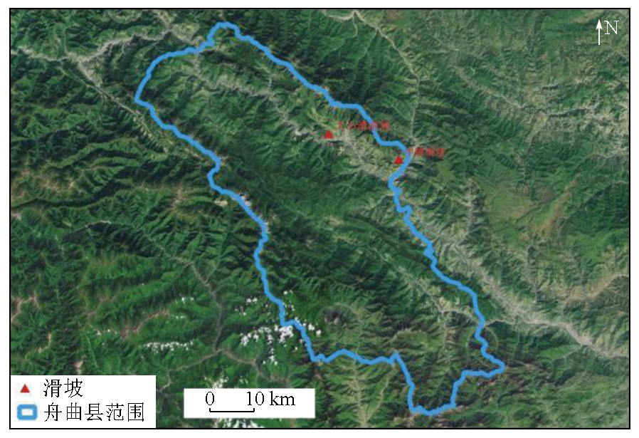
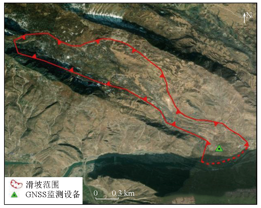
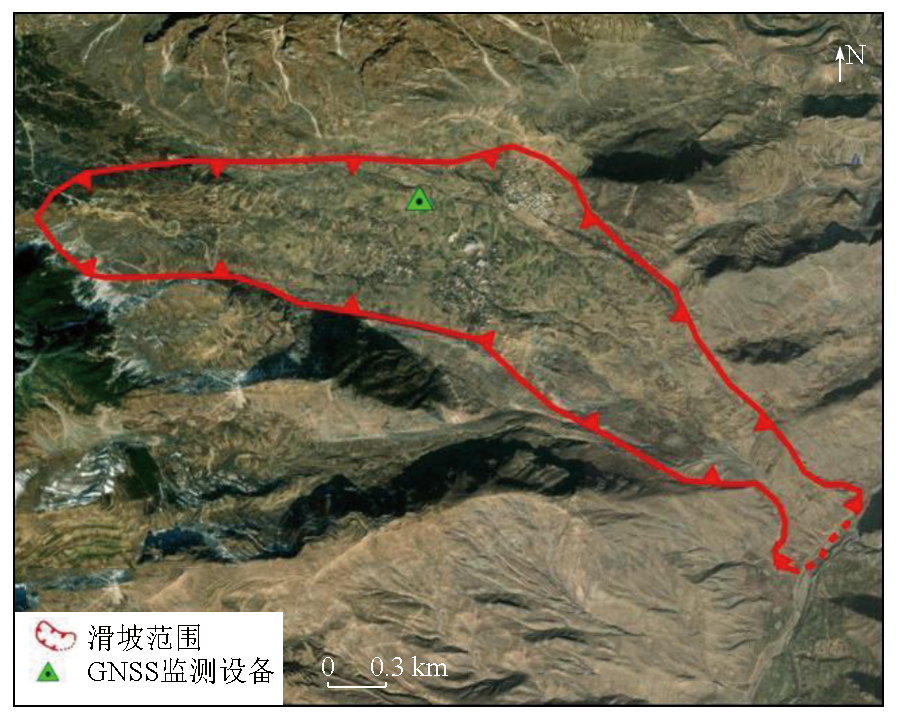
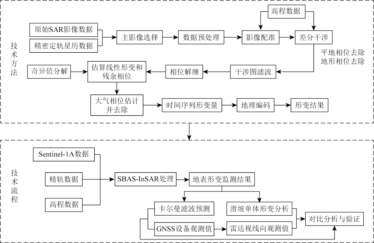
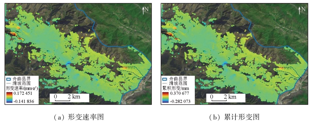
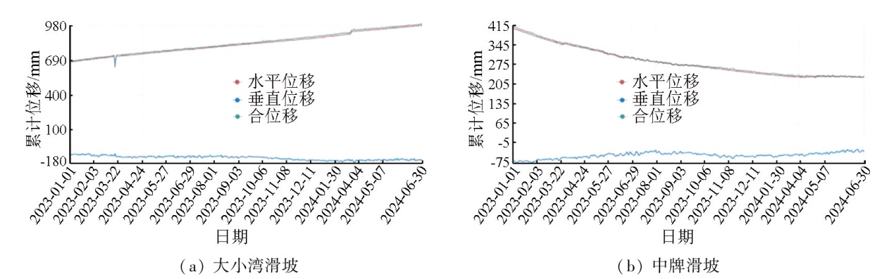
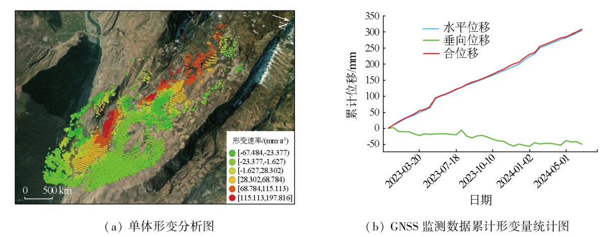
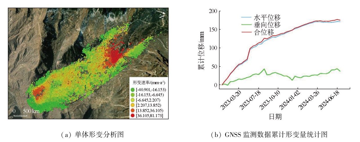
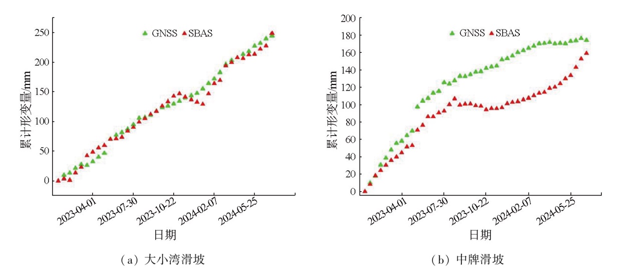
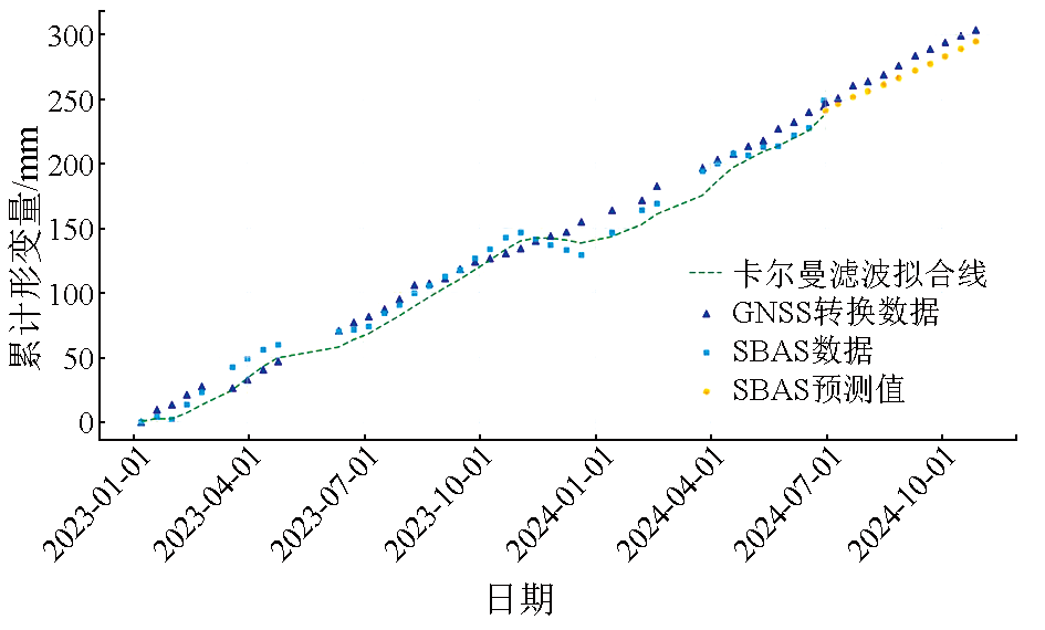
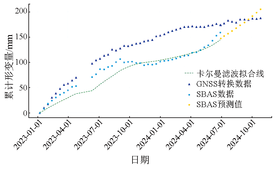
Given its all-day availability, all-weather adaptability, and high spatial resolution, the interferometric synthetic aperture radar (InSAR) technique has been widely applied in multiple fields, demonstrating strong adaptability and high practical value. Focusing on two typical landslide areas in Zhouqu County, Gansu Province, this study compared small baseline subset InSAR (SBAS-InSAR) monitoring results and Kalman filter prediction results with monitoring data from the global navigation satellite system (GNSS), confirming the reliability and accuracy of the SBAS-InSAR technique in monitoring landslide deformations. The results indicate that the SBAS-InSAR technique exhibited significant advantages in monitoring areas with deformations induced by geologic disasters, effectively overcoming the limitations of traditional monitoring means. This technique can provide critical technical support and scientific basis for early warning and management of geologic disasters in Zhouqu County and other areas prone to suffer these disasters.
Jiang J S, Zhang Y H, Dong X L. The discussion of up to date technologies in microwave remote sensing and the new generation of space remote sensing method[J]. Engineering Science, 2000, 2(8):76-82.
Chen R L, Wang H J, Diao X P, et al. Application of InSAR deformation monitoring in mining subsidence damage identification and stability evaluation[J]. Bulletin of Surveying and Mapping, 2023(12):106-111.
doi: 10.13474/j.cnki.11-2246.2023.0367
[6]
Li Z, Zhou J, Tian B. The glacier movement estimation and analysis with InSAR in the Qinghai-Tibetan Plateau[C]// 2009 IEEE International Geoscience and Remote Sensing Symposium. July 12-17,2009, Cape Town,South Africa.IEEE, 2009:II-578-II-581.
Liu F, Chen M, Zhu L, et al. Monitoring the land subsidence of Beijing City sub-center with ascending and descending Sentinel-1 data[J]. Geomatics World, 2021, 28(6):44-52.
[8]
Kubanek J, Westerhaus M, Schenk A, et al. Volumetric change quantification of the 2010 Merapi eruption using TanDEM-X InSAR[J]. Remote Sensing of Environment, 2015,164:16-25.
[9]
Massonnet D, Rossi M, Carmona C, et al. The displacement field of the Landers earthquake mapped by radar interferometry[J]. Nature, 1993, 364(6433):138-142.
doi: 10.1038/364138a0
Xu C J, Lin D L, Wen Y M. Extract and analysis surface deformation caused by Wenchuan Mw7.9 earthquake from InSAR data[J]. Geomatics and Information Science of Wuhan University, 2010, 35(10):1138-1142,1261-1262.
Qu C Y, Zhang G F, Shan X J, et al. Coseismic and postseismic deformation fields of the 2010 Yushu,Qinghai MS7.1 earthquake and their evolution processes[J]. Chinese Journal of Geophysics, 2013, 56(7):2280-2291.
Liu Z J, Han B Q, Neng Y H, et al. Source parameters and slip distribution of the 2023 mW 6.0 Jishishan(Gansu,China) earthquake constrained by InSAR observations[J]. Geomatics and Information Science of Wuhan University, 2025, 50(2):344-355.
[13]
Fruneau B, Achache J, Delacourt C. Observation and modelling of the Saint-Étienne-de-Tinée landslide using SAR interferometry[J]. Tectonophysics, 1996, 265(3/4):181-190.
doi: 10.1016/S0040-1951(96)00047-9
Dai C, Li W L, Lu H Y, et al. Active landslides detection in Zhouqu County,Gansu Province using InSAR technology[J]. Geomatics and Information Science of Wuhan University, 2021, 46(7):994-1002.
Yu J X, Zheng W J, Yuan D Y, et al. Late quaternary active characteristics and slip-rate of pingdinghuama fault,the eastern segment of Guanggaishan-dieshan fault zone(west Qinling mountain)[J]. Quaternary Sciences, 2012, 32(5):957-967.
Li Y X, Zhang Y, Meng X M, et al. Analysis the activity characteristics of the giant landslide in active tectonic fault zone:A case study of Daxiaowan landslide in Bailong River Basin[J]. Journal of Lanzhou University (Natural Sciences), 2021, 57(3):360-368.
Yang W M, Huang X, Zhang C S, et al. Deformation behavior of landslides and their formation mechanism along Pingding-Huama active fault in Bailongjiang River Region[J]. Journal of Jilin University (Earth Science Edition), 2014, 44(2):574-583.
Yang W M, Huang X, Zhang Y S, et al. The deformation characteristics of the landslide along Pingding-Huama active fault zone and its prevention and control[J]. Geological Bulletin of China, 2013, 32(12):1925-1935.
Liu B, Zhang L, Li M, et al. InSAR landslide deformation time sequence monitoring method fusing CR and GNSS and storage medium:China,CN117761716A[P].2024-03-26.
[21]
Lu F, Zeng H. Application of Kalman filter model in the landslide deformation forecast[J]. Scientific Reports, 2020, 10(1):1028.
doi: 10.1038/s41598-020-57881-3
pmid: 31974439
Zhou X L, Shi P Q. Monitoring and analysis of surface deformation in Huating City,Gansu Province based on SBAS-InSAR technology[J]. Geomatics & Spatial Information Technology, 2023, 46(2):30-33,38.
Jiang D C, Zheng X X, Wang N, et al. Application of the time-series InSAR technology in the identification of geological hazards in the Pearl River Delta region[J]. Remote Sensing for Natural Resources, 2023, 35(3):292-301.doi:10.6046/zrzyyg.2022190.
[24]
Berardino P, Fornaro G, Lanari R, et al. A new algorithm for surface deformation monitoring based on small baseline differential SAR interferograms[J]. IEEE Transactions on Geoscience and Remote Sensing, 2002, 40(11):2375-2383.
doi: 10.1109/TGRS.2002.803792
 2025, Vol. 37
  ), 石鹏卿1,2,3(