Whole-process deformation monitoring of the Baige landslide in Tibet before and after instability based on multisource remote sensing images
YANG Chengsheng1(), WEI Chunrui1,2(), WEI Yunjie3, LI Zufeng4, DING Huilan1
1. College of Geological Engineering and Geomatics, Chang’an University, Xi’an 710054, China 2. 149th Team,Gansu Coal Geology Bureau, Lanzhou 730020, China 3. China Institute of Geological Environment Monitoring, Beijing 100081, China 4. Northwest Engineering Corporation Limited, PowerChina, Xi’an 710065, China
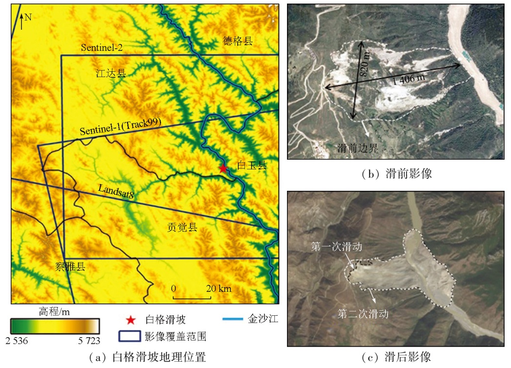
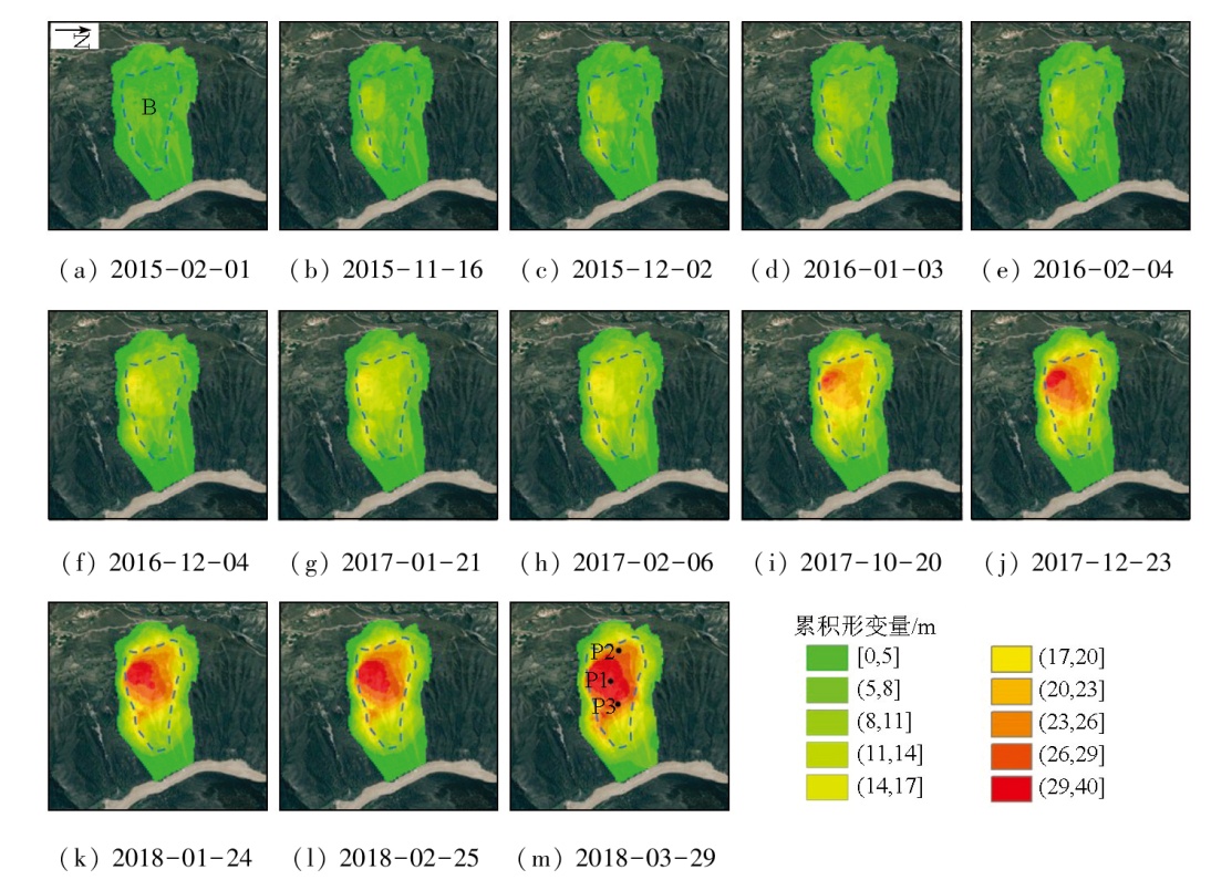
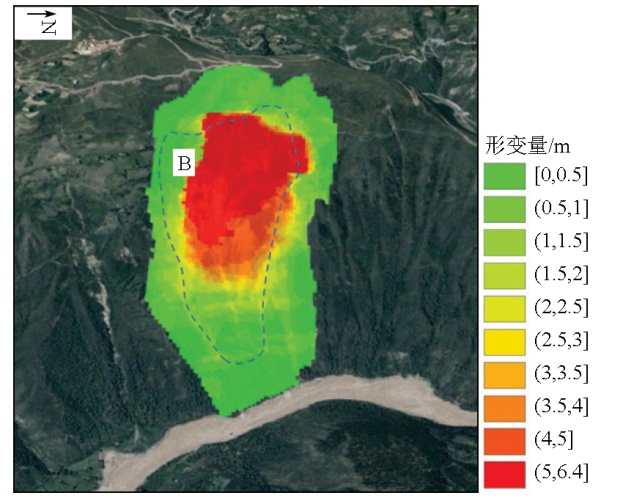
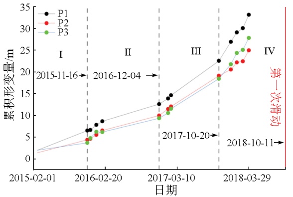
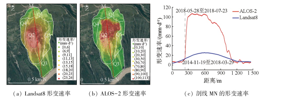
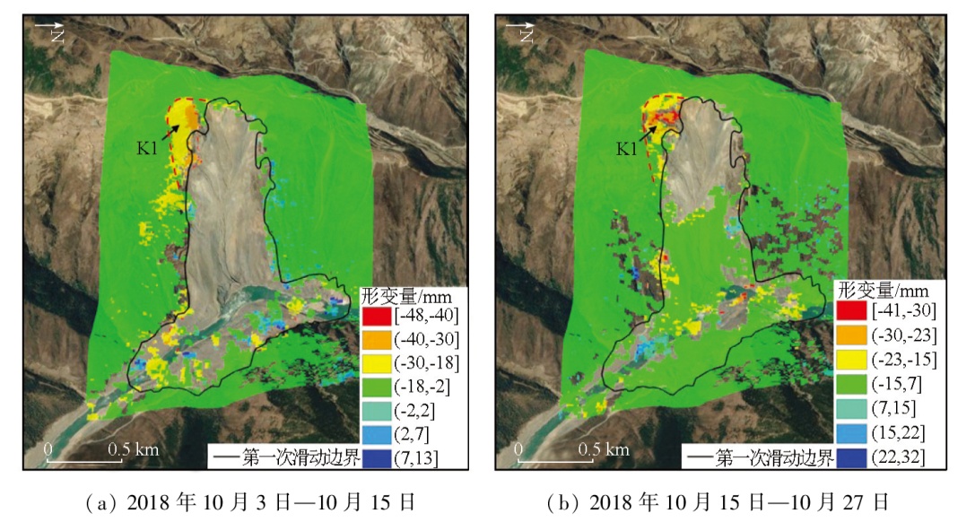
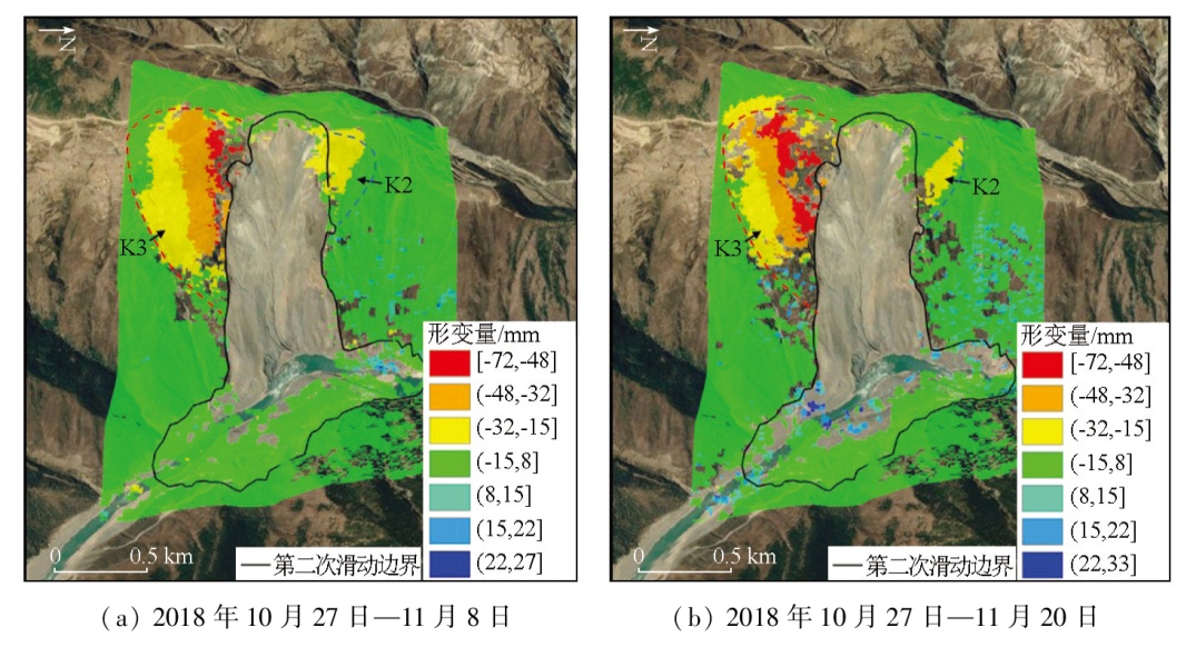
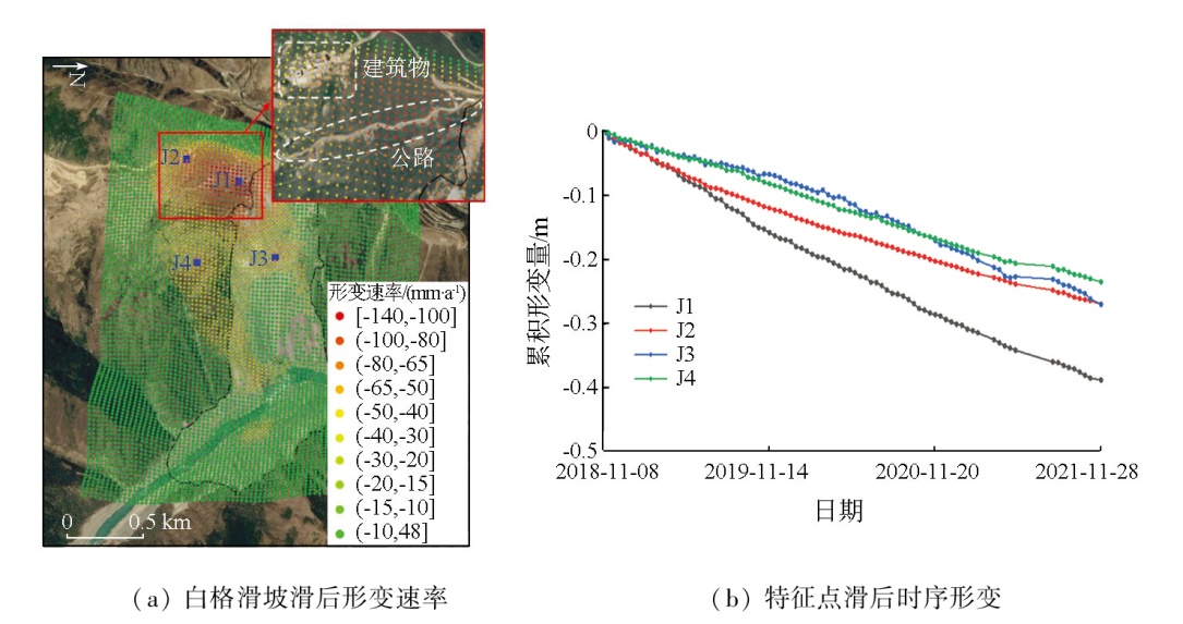
The Baige landslide occurred twice in October and November 2018, causing huge economic losses and extensive social impact. Monitoring the activity characteristics of the Baige landslide in various stages based on multisource data is significant for understanding the failure mechanism of this landslide. With Sentinel-1, ALOS-2, and Landsat8 data as data sources, this study derived the deformation characteristics of the Baige landslide before, during, and after two slide events using techniques, such as small baseline subset-interferometric synthetic aperture radar (SBAS-InSAR), SAR offset tracking, and optical offset tracking. The optical offset calculation results show that from November 2014 to March 29, 2018 in the pre-sliding stage, the cumulative displacement of the Baige landslide reached 40 m, with deformation concentrated in the middle of the landslide. The SAR offset results indicate that the cumulative displacement of the landslide reached 6.4 m in May and July 2018 in the pre-sliding stage, with deformation also concentrated in the middle of the landslide. The InSAR-based monitoring results reveal that after the two failures of the Baige landslide in October and November 2018, significant residual deformation remained in the trailing edge and upper left side of the landslide. From November 2018 to November 2021 in the post-sliding stage, the Baige landslide exhibited a deformation rate of -140 mm/y at the high trailing edge of the landslide, and the deformation range on the upper left side continued to expand. All the results of this study reconstructed the whole sliding process of the Baige landslide subjected to large displacements, providing a valuable reference for the monitoring and early warning of landslides.
杨成生, 魏春蕊, 魏云杰, 李祖锋, 丁慧兰. 基于多源遥感影像的西藏白格滑坡失稳前后全过程形变监测研究[J]. 自然资源遥感, 2025, 37(3): 203-211.
YANG Chengsheng, WEI Chunrui, WEI Yunjie, LI Zufeng, DING Huilan. Whole-process deformation monitoring of the Baige landslide in Tibet before and after instability based on multisource remote sensing images. Remote Sensing for Natural Resources, 2025, 37(3): 203-211.
Xu Q, Zheng G, Li W L, et al. Study on successive landslide damming events of Jinsha River in Baige Village on Octorber 11 and November 3,2018[J]. Journal of Engineering Geology, 2018, 26(6):1534-1551.
[2]
Colesanti C, Wasowski J. Investigating landslides with space-borne Synthetic Aperture Radar (SAR) interferometry[J]. Engineering Geology, 2006, 88(3-4):173-199.
[3]
Kang Y, Zhao C Y, Zhang Q, et al. Application of InSAR techniques to an analysis of the Guanling landslide[J]. Remote Sen-sing, 2017, 9(10):1046.
[4]
Berardino P, Fornaro G, Lanari R, et al. A new algorithm for surface deformation monitoring based on small baseline differential SAR interferograms[J]. IEEE Transactions on Geoscience and Remote Sensing, 2002, 40(11):2375-2383.
Fan J H, Qiu K T, Xia Y, et al. InSAR monitoring and synthetic analysis of the surface deformation of Fanjiaping landslide in the Three Gorges Reservoir area[J]. Geological Bulletin of China, 2017, 36(9):1665-1673.
Zhu T T, Shi X G, Zhou C, et al. Stability monitoring and analysis of the Shuping landslide in the Three Gorges Area with Sentinel-1 images from 2016 to 2020[J]. Geomatics and Information Science of Wuhan University, 2021, 46(10):1560-1568.
Feng W K, Dun J W, Yi X Y, et al. Deformation analysis of Woda Village old landslide in Jinsha River Basin using SBAS-InSAR technology[J]. Journal of Engineering Geology, 2020, 28(2):384-393.
[8]
Delacourt C, Allemand P, Casson B, et al. Velocity field of the “La Clapière” landslide measured by the correlation of aerial and QuickBird satellite images[J]. Geophysical Research Letters, 2004, 31(15):L15619.
[9]
Lucieer A, de Jong S M, Turner D. Mapping landslide displacements using Structure from Motion (SfM) and image correlation of multi-temporal UAV photography[J]. Progress in Physical Geo-graphy:Earth and Environment, 2014, 38(1):97-116.
[10]
Liu X, Zhao C, Zhang Q, et al. Deformation of the Baige landslide,Tibet,China,revealed through the integration of cross-platform ALOS/PALSAR-1 and ALOS/PALSAR-2 SAR observations[J]. Geophysical Research Letters, 2020, 47(3):e2019GL086142.
Wang Q, Zhang Y L, Fan J H, et al. Deformation monitoring of the Baige landslide in the Jinsha River using PS-InSAR and offset tracking techniques[J]. Journal of Geodesy and Geodynamics, 2020, 40(4):340-345.
Liu L, Song H F, Du Y N, et al. Time-series offset tracking of the Baige landslide based on Sentinel-2 and Landsat8[J]. Geomatics and Information Science of Wuhan University, 2021, 46(10):1461-1470.
Xu X B, Ma C, Shan X J, et al. Monitoring ground subsidence in high-intensity mining area by integrating DInSAR and Offset-tracking technology[J]. Journal of Geo-Information Science, 2020, 22(12):2425-2435.
Sun J, Zhang J. Ground deformation monitoring of open-pit coal mine based on SBAS-InSAR and offset tracking techniques[J]. Safety in Coal Mines, 2022, 53(3):162-169.
Huang J H, Xie M W, Wang L W. Study on deformation monitoring of Baige landslide based on SBAS-InSAR technology[J]. Yangtze River, 2019, 50(12):101-105.
Mo Y J, Wu Y, Liu X W. Monitoring the ground subsidence in Xiaojin County,Sichuan Province based on small baseline subset technique[J]. Engineering of Surveying and Mapping, 2018, 27(11):46-50.
Gao W J. Research on surface deformation in the west of Shenzhen based on SBAS-InSAR technology[D]. Xi’an: Xi’an University of Science and Technology, 2021.
[18]
Ou D, Tan K, Du Q, et al. Decision fusion of D-InSAR and pixel offset tracking for coal mining deformation monitoring[J]. Remote Sensing, 2018, 10(7):1055.
[19]
Stumpf A, Malet J P, Allemand P, et al. Surface reconstruction and landslide displacement measurements with Pléiades satellite images[J]. ISPRS Journal of Photogrammetry and Remote Sensing, 2014,95:1-12.
He L J, Feng G C, Feng Z X, et al. Coseismic displacements of 2016 MW7.8 Kaikoura,New Zealand earthquake,using Sentinel-2 optical images[J]. Acta Geodaetica et Cartographica Sinica, 2019, 48(3):339-351.
[21]
Li M, Zhang L, Ding C, et al. Retrieval of historical surface displacements of the Baige landslide from time-series SAR observations for retrospective analysis of the collapse event[J]. Remote Sensing of Environment, 2020,240:111695.
[22]
Xiong Z Q, Feng G C, Feng Z X, et al. Pre- and post-failure spatial-temporal deformation pattern of the Baige landslide retrieved from multiple radar and optical satellite images[J]. Engineering Geology, 2020,279:105880.
 2025, Vol. 37
  ), 魏春蕊1,2(