|
|
 |
|

|
|
|
Application of mine remote sensing monitoring to analysis of mine goaf stability |
| Xianhua YANG1,2, Jie HUANG1,2, Li TIAN1, Bei PENG1, Lixiao XIAO1, Xinlong SONG1 |
1. Sichuan Institute of Geological Survey, Chengdu 610081, China
2. Evaluation and Utilization of Strategic Rare Metals and Rare Earth Resource Key Laboratory of Sichuan Province, Chengdu 610081, China |
|
|
|
|
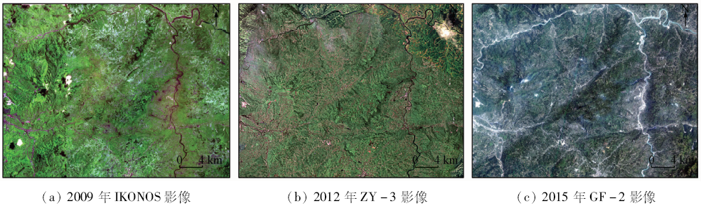
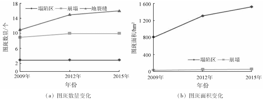
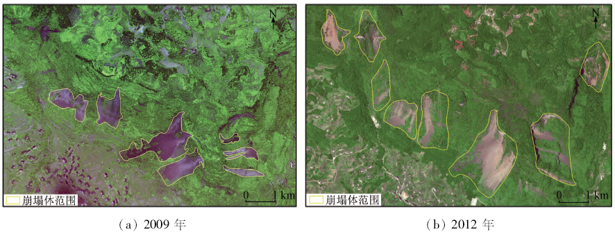
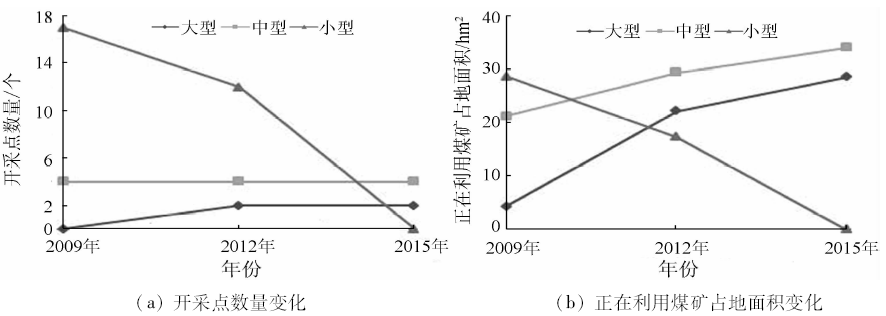
Abstract Focused on deformation trends of mine goaf areas, the remote sensing monitoring techniques were employed to interpret and compare the multi-temporal satellite images. According to images acquired in 2009, 2012 and 2015 respectively, land cover change information including mine goaf areas, mine digging points and other land use types in the Junlian coal mining area of Sichuan Province were acquired. By analyzing the correlation between the mining exploitation environment changes and mine goaf area change trends, the authors pointed out that the status alteration of coal mining can directly affect the mine goaf change trend. On the basis of the remote sensing monitoring results, stability analysis of mine goaf areas was conducted, the continuous and newly increased deformation information was calculated, and the categorized prediction maps of mine goaf deformation trends were presented, which can assist further specified measures for mining environment protection.
|
| Keywords
remote sensing monitoring
mining exploitation
mine goaf
deformation stability
mine environment
|
|
|
|
Issue Date: 10 September 2018
|
|
|
| [1] |
黄洁, 邵怀勇, 杨显华 , 等. 四川省矿山开发遥感监测方法与实践[M]. 北京: 测绘出版社, 2013: 31-36.
|
| [1] |
Huang J, Shao H Y, Yang X H , et al. Methods and Practice on Remote Sensing Monitoring of Mine Development in Sichuan Province[M]. Beijing: Surveying and Mapping Press, 2013: 31-36.
|
| [2] |
查东平, 申展, 刘足根 , 等. 基于TM影像的德兴铜矿区生态环境变化[J]. 国土资源遥感, 2015,27(4):109-114.doi: 10.6046/gtzyyg.2015.04.17.
doi: 10.6046/gtzyyg.2015.04.17
|
| [2] |
Zha D P, Shen Z, Liu Z G , et al. Changes of ecological environment in the Dexing copper mine based on TM images[J]. Remote Sensing for Land and Resources, 2015,27(4):109-114.doi: 10.6046/gtzyyg.2015.04.17.
|
| [3] |
柴华彬, 宋博, 刘瑞斌 , 等. 煤矿塌陷区地基稳定性与承载力研究现状分析[J]. 河南理工大学学报(自然科学版), 2014,33(2):173-176.
|
| [3] |
Chai H B, Song B, Liu R B , et al. Research status of foundation bearing capacity in coal mining subsidence area[J]. Journal of Henan Polytechnic University(Natural Science), 2014,33(2):173-176.
|
| [4] |
张德强, 张进德, 白光宇 , 等. 采煤塌陷区稳定性分析研究[J]. 水文地质工程地质, 2012,39(5):93-97.
|
| [4] |
Zhang D Q, Zhang J D, Bai G Y , et al. A study of the stability analysis of ground collapse in goaf of coal mine[J]. Hydrogeology and Engineering Geology, 2012,39(5):93-97.
|
| [5] |
郝宪杰, 贺菲, 郝宪威 . 煤炭开采引起的采空塌陷问题与对策[J].能源技术与管理, 2009(2):86-88.
|
| [5] |
Hao X J, He F, Hao X W . The problem and countermeasures of mining collapse on coal mining[J].Energy Technology and Management, 2009(2):86-88.
|
| [6] |
王晓红, 聂洪峰, 李成尊 , 等. 不同遥感数据源在矿山开发状况及环境调查中的应用[J]. 国土资源遥感, 2006,18(2):69-71.doi: 10.6046/gtzyyg.2006.02.17.
doi: 10.3969/j.issn.1001-070X.2006.02.017
url: http://d.wanfangdata.com.cn/Periodical/gtzyyg200602017
|
| [6] |
Wang X H, Nie H F, Li C Z , et al. The application of characteristics of different remote sensing data sources to the investigation of the mining situation and environment of mines[J]. Remote Sensing for Land and Resources, 2006,18(2):69-71.doi: 10.6046/gtzyyg.2006.02.17.
|
| [7] |
王海庆, 聂洪峰, 陈玲 , 等. 采矿沉陷遥感调查与危害性研究[J]. 国土资源遥感, 2016,28(1):114-121.doi: 10.6046/gtzyyg.2016.01.17.
doi: 10.6046/gtzyyg.2016.01.17
|
| [7] |
Wang H Q, Nie H F, Chen L , et al. Remote sensing investigation of mining subsidence and harmfulness research[J]. Remote Sensing for Land and Resources, 2016,28(1):114-121.doi: 10.6046/gtzyyg.2016.01.17.
|
| [8] |
王钦军, 陈玉, 蔺启忠 . 矿山地面塌陷的高分辨率遥感识别与边界提取[J]. 国土资源遥感, 2011,23(3):113-116.doi: 10.6046/gtzyyg.2011.03.20.
doi: 10.6046/gtzyyg.2011.03.20
url: 年度引用
|
| [8] |
Wang Q J, Chen Y, Lin Q Z . Surface collapse identification and its boundary extraction using high resolution remote sensing[J]. Remote Sensing for Land and Resources[J]. 2011,23(3):113-116.doi: 10.6046/gtzyyg.2011.03.20.
|
| [9] |
刘广, 郭华东, Ramon H , 等. InSAR技术在矿区沉降监测中的应用研究[J]. 国土资源遥感, 2008,20(2):51-55.doi: 10.6046/gtzyyg.2008.02.13.
doi: 10.6046/gtzyyg.2008.02.13
url: 年度引用
|
| [9] |
Liu G, Guo H D, Ramon H , et al. The application of InSAR technology to mining area subsidence monitoring[J]. Remote Sensing for Land and Resources, 2008,20(2):51-55.doi: 10.6046/gtzyyg.2008.02.13.
|
| [10] |
杨显华, 黄洁, 田立 , 等. 基于高分辨率遥感数据的矿山环境综合治理研究——以冕宁牦牛坪稀土矿为例[J]. 国土资源遥感, 2015,27(4):115-121.doi: 10.6046/gtzyyg.2015.04.18.
doi: 10.6046/gtzyyg.2015.04.18
|
| [10] |
Yang X H, Huang J, Tian L , et al. A discussion on comprehensive governance of mine environment based on high resolution remote sensing data:A case of Maoniuping REE deposit, Mianning County[J]. Remote Sensing for Land and Resources, 2015,27(4):115-121.doi: 10.6046/gtzyyg.2015.04.18.
|
| [11] |
杨显华, 黄洁, 田立 , 等. 四川省矿山遥感监测主要成果与进展[J]. 中国地质调查, 2016,3(5):41-47.
|
| [11] |
Yang X H, Huang J, Tian L , et al. Major achievements and progress of remote sensing monitoring mines in Sichuan Province[J]. Geological Survey of China, 2016,3(5):41-47.
|
| [12] |
李丽, 汪洁, 汪劲 , 等. 基于高分卫星遥感数据的金属矿开发现状及环境问题研究——以江西省德兴多金属矿集区为例[J]. 中国地质调查, 2016,3(5):60-66.
url: http://d.wanfangdata.com.cn/Periodical/zgdzdc201605010
|
| [12] |
Li L, Wang J, Wang J , et al. Study of metal mine development situation and environmental problems using high resolution satellite remote sensing data:A case of polymetallic ore concentration area in Dexing,Jiangxi Province[J]. Geological Survey of China, 2016,3(5):60-66.
|
| [13] |
路云阁, 王昊, 刘采 . 西藏东部地区矿产资源开发环境遥感监测成果[J]. 中国地质调查, 2016,3(5):35-40.
|
| [13] |
Lu Y G, Wang H, Liu C . Review of remote sensing investigation of mineral resources development status in eastern Tibet[J]. Geological Survey of China, 2016,3(5):35-40.
|
| [14] |
强建华, 于浩 . 新疆矿山环境遥感监测成果综述[J]. 中国地质调查, 2016,3(5):28-34.
|
| [14] |
Qiang J H, Yu H . Review on remote sensing monitoring results of mine geological environment in Xinjiang[J]. Geological Survey of China, 2016,3(5):28-34.
|
| [15] |
薛庆, 吴蔚, 李名松 , 等. 遥感技术在辽宁省矿山环境监测中的应用[J]. 中国地质调查, 2016,3(5):54-59.
|
| [15] |
Xue Q, Wu W, Li M S , et al. Application of remote sensing technology in mine environment monitoring in Liaoning Province[J]. Geological Survey of China, 2016,3(5):54-59.
|
| [16] |
董双发, 梁鑫, 吴蔚 , 等. 内蒙古西部地区矿山遥感调查与监测[J]. 中国地质调查, 2016,3(5):48-53.
|
| [16] |
Dong S F, Liang X, Wu W , et al. Mine remote sensing investigation and monitoring in western Inner Mongolia[J]. Geological Survey of China, 2016,3(5):48-53.
|
| [17] |
尚娟芳, 唐益林, 刘朝明 , 等. 宜宾市矿产资源开发利用对策研究[J]. 中国矿业, 2014,23(S2):41-43,46.
doi: 10.3969/j.issn.1004-4051.2014.z2.011
url: http://d.wanfangdata.com.cn/Periodical/zgky2014z2011
|
| [17] |
Shang J F, Tang Y L, Liu C M , et al. Countermeasures of mineral resources development and utilization in Yibin[J]. China Mining Magazine, 2014,23(S2):41-43,46.
|
| [18] |
张君, 黑广民, 沈锐 , 等. 筠连县地质灾害调查与区划报告[R]. 绵阳:四川省地矿局九O九水文地质工程地质队, 2006.
|
| [18] |
Zhang J, Hei G M, Shen R , et al. Geological Hazard Investigation and Regionalization Report in Junlian[R]. Mianyang: 909 Hydrogeology and Engineering Geology Team of Sichuan Bureau of Geology and Mineral Resources, 2006.
|
| [19] |
杨金中, 秦绪文, 聂洪峰 , 等. 矿山遥感监测工作指南[M]. 北京: 中国大地出版社, 2011.
|
| [19] |
Yang J Z, Qin X W, Nie H F , et al. A Guide to Mine Remote Sensing Monitoring[M]. Beijing: China Land Press, 2011.
|
| [20] |
中国地质调查局. DD2011-06矿产资源开发遥感监测技术要求[S]. 北京:中国地质调查局, 2011.
|
| [20] |
China Geological Survey. DD2011-06 Regulation on Remote Sensing Monitoring of Mining Exploration[S]. Beijing:China Geological Survey, 2011.
|
| [21] |
四川省人民政府. 四川省矿产资源总体规划(2008—2015年)[S]. 成都:四川省人民政府, 2010.
|
| [21] |
Sichuan Provincial People’s Government. The Overall Mineral Resources Planning in Sichuan Province(2008─2015)[S]. Chengdu:Sichuan Provincial People’s Government, 2010.
|
| [22] |
孙文华 . 三下采煤新技术应用与煤柱留设及压煤开采规程实用手册[M]. 北京: 中国煤炭出版社, 2013.
|
| [22] |
Sun W H. Practical Manual of Application of New Technology of Coal Mining and Coal Pillar Design and Coal Mining Practice[M]. Beijing: China Coal Press, 2013.
|
| [23] |
于晶玲 . 雷家井采空塌陷的沉降量预测及防治措施[J]. 铁路工程造价管理, 2009,24(2):38-41.
|
| [23] |
Yu J L . Predictions and preventions of Leijiajing subsidence areas[J]. Railway Engineering Cost Management, 2009,24(2):38-41.
|
| [24] |
从常奎, 陈娜, 朱磊 . 煤矿开采沉陷及其治理对策[J]. 陕西煤炭, 2008,27(3):7-9.
doi: 10.3969/j.issn.1671-749X.2008.03.003
url: http://d.wanfangdata.com.cn/Periodical/shanxmt200803003
|
| [24] |
Cong C K, Chen N, Zhu L . Mining subsidence and control countermeasures[J]. Shanxi Coal Industry, 2008,27(3):7-9.
|
|
Viewed |
|
|
|
Full text
|
|
|
|
|
Abstract
|
|
|
|
|
Cited |
|
|
|
|
| |
Shared |
|
|
|
|
| |
Discussed |
|
|
|
|
 2018,
Vol. 30
2018,
Vol. 30