| Orginal Article |
|
 |
|

|
|
|
A comprehensive change detection method for updating land cover data base |
Jiaojiao DIAO1,2( ), Xinye GONG1,2, Mingshi LI1,2() ), Xinye GONG1,2, Mingshi LI1,2() |
1.College of Forestry, Nanjing Forestry University, Nanjing 210037, China
2. Co-Innovation Center for Sustainable Forestry in Southern China, Nanjing Forestry University, Nanjing 210037, China |
|
|
|
|
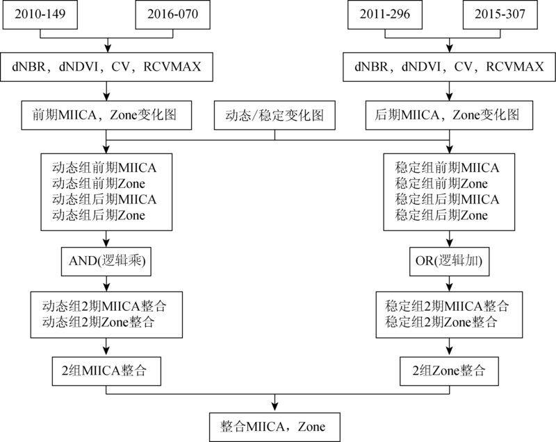
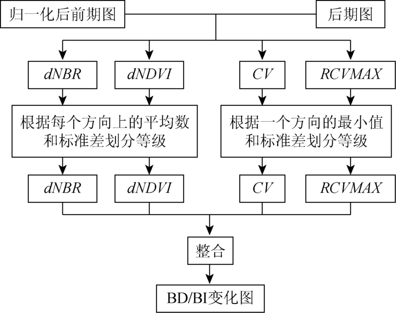
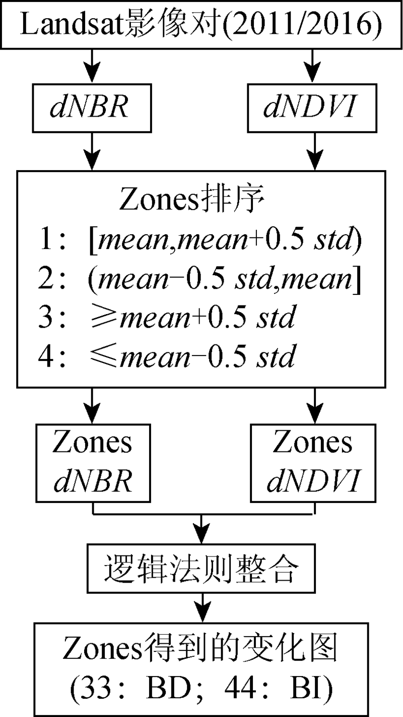
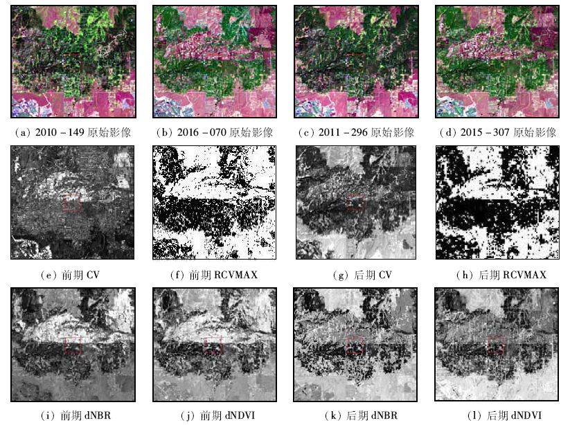
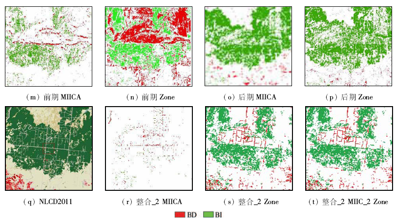
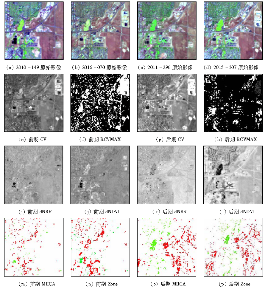
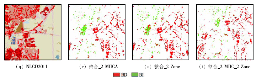
Abstract Describing, quantifying and monitoring land use/land cover change play an important role in the global and environmental change investigation. Based on a comprehensive change detection method (CCDM), the authors mapped the land cover changes in the period between 2011 and 2016 over the Landsat image (Path33/Row33). CCDM integrates some spectral change based detection algorithms, which encompasses the multi-index integrated change analysis (MIICA) model and the Zone model, with an emphasis or core on MIICA. By calculating four spectral indices including change vector (CV), relative change vector maximum (RCVMAX), differenced normalized burn ratio (dNBR) and differenced normalized difference vegetation index (dNDVI), the land cover changes were extracted from the bi-temporal imagery. According to the previous and the current land cover change trends, coupled with the changes in results from MIICA and Zone models, the accuracies of change detection results by CCDM were evaluated. The results show that there is an accuracy of 96% for the category of no-change, and 40% for change category, with an overall accuracy of 68%. The CCDM is a simple, easily realized and widely used model to capture the potential land cover changes caused by the diverse natural and anthropengic disturbances in different landscapes.
|
| Keywords
comprehensive change detection method(CCDM)
land cover change
remote sensing detection
accuracy assessment
|
|
|
|
Issue Date: 08 February 2018
|
|
|
| [1] |
陈广生,田汉勤.土地利用/覆盖变化对陆地生态系统碳循环的影响[J].植物生态学报,2007,31(2):189-204.
|
| [1] |
Chen G S,Tian H Q.Land use/cover change effects on carbon cycling in terrestrial ecosystems[J].Journal of Plant Ecology,2007,31(2):189-204.
|
| [2] |
Coppin P,Jonckheere I,Nackaerts K,et al.Review Article Digital change detection methods in ecosystem monitoring:A review[J].International Journal of Remote Sensing,2004,25(9):1565-1596.
|
| [3] |
Homer C,Dewitz J,Fry J,et al.Completion of the 2001 national land cover database for the counterminous United States[J].Photogrammetric Engineering and Remote Sensing,2007,73(4):337-341.
|
| [4] |
Xian G,Crane M.Assessments of urban growth in the Tampa Bay watershed using remote sensing data[J].Remote Sensing of Environment,2005,97(2):203-215.
|
| [5] |
Pouliot D,Latifovic R,Olthof I.Trends in vegetation NDVI from 1 km AVHRR data over Canada for the period 1985—2006[J].International Journal of Remote Sensing,2009,30(1):149-168.
|
| [6] |
Zhan X,Defries R,Townshend J R G,et al.The 250 m global land cover change product from the moderate resolution imaging spectroradiometer of NASA’s earth observing system[J].International Journal of Remote Sensing,2000,21(6/7):1433-1460.
|
| [7] |
黄维,黄进良,王立辉,等.基于PCA的变化向量分析法遥感影像变化检测[J].国土资源遥感,2016,28(1):22-27.doi:10.6046/gtzyyg.2016.01.04.
|
| [7] |
Huang W,Huang J L,Wang L H,et al.Remote sensing image change detection based on change vector analysis of PCA component[J].Remote Sensing for Land and Resources,2016,28(1):22-27.doi:10.6046/gtzyyg.2016.01.04.
|
| [8] |
常潇,肖鹏峰,冯学智,等.近30年长江中下游平原典型区耕地覆盖变化[J].国土资源遥感,2014,26(2):170-176.doi:10.6046/gtzyyg.2014.02.27.
|
| [8] |
Chang X,Xiao P F,Feng X Z,et al.Change of cropland in typical area of Middle-Lower Yangtze Plain over the past 30 years[J].Remote Sensing for Land and Resources,2014,26(2):170-176.doi:10.6046/gtzyyg.2014.02.27.
|
| [9] |
Huang C Q,Song K,Kim S,et al.Use of a dark object concept and support vector machines to automate forest cover change analysis[J].Remote Sensing of Environment,2008,112(3):970-985.
|
| [10] |
Kennedy R E,Yang Z Q,Cohen W B.Detecting trends in forest disturbance and recovery using yearly Landsat time series:1.LandTrendr-Temporal segmentation algorithms[J].Remote Sensing of Environment,2010,114(12):2897-2910.
|
| [11] |
Li M S,Huang C Q,Shen W J,et al.Characterizing long-term forest disturbance history and its drivers in the Ning-Zhen Mountains,Jiangsu Province of eastern China using yearly Landsat observations(1987-2011)[J].Journal of Forestry Research,2016,27(6)1329-1341.
|
| [12] |
Latifovic R,Pouliot D.Multitemporal land cover mapping for Canada: methodology and products[J].Canadian Journal of Remote Sensing,2005,31(5):347-363.
|
| [13] |
Jin S M,Yang L M,Danielson P,et al.A comprehensive change detection method for updating the National Land Cover Database to circa 2011[J].Remote Sensing of Environment,2013,132:159-175.
|
| [14] |
Weatherbase.Denver,Colorado Travel Weather Averages[EB/OL].[2013-07-10]..
url: http://www.weatherbase.com/weather/weather.php3?s=096427&refer=&cityname=Denver-Colorado-United-States-of-America
|
| [15] |
Key C H,Benson N C.Measuring and remote sensing of burn severity[C]//Neuenschwander L F,Ryan K C,Gollberg G E.Proceedings of Joint Fire Science Conference and Workshop:Crossing the Millennium:Integrating Spatial Technologies and Ecological Principles for A New Age in Fire Management.Boise,Idaho:University of Idaho and the International Association of Wildland Fire,1999:284.
|
| [16] |
魏新彩,王新生,刘海,等.HJ卫星图像水稻种植面积的识别分析[J].地球信息科学学报,2012,14(3):382-388.
|
| [16] |
Wei X C,Wang X S,Liu H,et al.Extraction of paddy rice coverage based on the HJ satellite data[J].Journal of Geo-Information Science,2012,14(3):382-388.
|
| [17] |
谭柳霞,曾永年,郑忠.林火烈度遥感评估指数适应性分析[J].国土资源遥感,2016,28(2):84-90.doi:10.6046/gtzyyg.2016.02.14.
|
| [17] |
Tan L X,Zeng Y N,Zheng Z.An adaptability analysis of remote sensing indices in evaluating fire severity[J].Remote Sensing for Land and Resources,2016,28(2):84-90.doi:10.6046/gtzyyg.2016.02.14.
|
| [18] |
López García M J,Caselles V.Mapping burns and natural reforestation using Thematic Mapper data[J].Geocarto International,1991,6(1):31-37.
|
| [19] |
吴俊,孟庆岩,占玉林,等.一种基于移动窗口的城市绿度遥感度量方法[J].地球信息科学学报,2016,18(4):544-552.
|
| [19] |
Wu J,Meng Q Y,Zhan Y L,et al.A measure of urban green index in urban areas based on moving window method[J].Journal of Geo-information Science,2016,18(4):544-552.
|
|
Viewed |
|
|
|
Full text
|
|
|
|
|
Abstract
|
|
|
|
|
Cited |
|
|
|
|
| |
Shared |
|
|
|
|
| |
Discussed |
|
|
|
|
 2018,
Vol. 30
2018,
Vol. 30