|
|
|
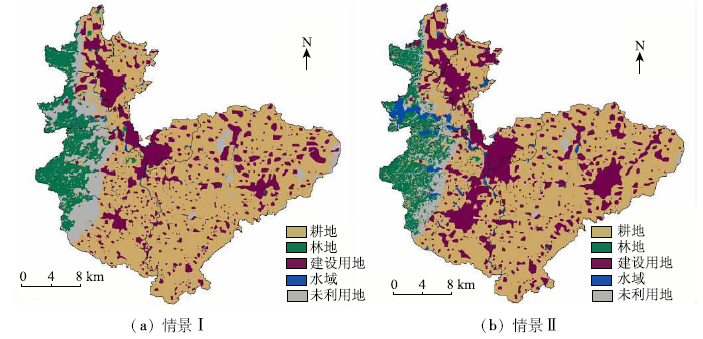
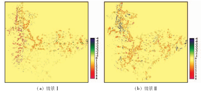
Abstract In the period of “13th Five-Year Plan”, the national planning attaches great importance to the implementation of construction of the high standard grain area. As one of the high standard grain areas in Henan Province, Hebi City shoulders the burden of ensuring food security. That is why it is of practical significance to study the simulation and prediction of land use in Hebi City in the future. With the use of CA-Markov model and on the basis of the historical process of the coordinated development of urbanization, industrialization and agricultural modernization of Henan Province, the prediction can be divided into two scenarios for the simulation and prediction of land use according to the analysis of the characteristics of land use in Hebi city in the past 20 years. The results can show that the Kappa index of Hebi City in 2013 was about 0.898, which means that the fitting effect is the best, and that the prediction results of CA-Markov model can achieve good fitting effect. Based on comparative analysis of the quantity, the space and the landscape index of Hebi City, it is held that the scenario II can be more in line with the demand of the Central Plains Economic Area and the industrial development as well as with the “green development” in the High Standard Grain Area’s ecological and environmental protection grounds. What’s more, it is in accordance with the planning of Hebi City, the patch shape is more regular, the plaque agglomeration degree is high, the internal continuity is strong, landscape fragmentation degree is low, and the landscape distribution is uniform, thus exhibiting obvious advantages. The authors hold that, in the future, the government should adhere to scenario II model for the development of the construction of the High Standard Grain Area so that the land can realize sustainable development.
|
| Keywords
high standard grain area
land use
CA-Markov
simulation and prediction
Hebi City
|
|
|
|
Issue Date: 08 February 2018
|
|
|
| [1] |
Parker D C,Manson S M,Janssen M A,et al.Multi-agent systems for the simulation of land-use and land-cover change:A review[J].Annals of the Association of American Geographers,2003,93(2):314-337.
|
| [2] |
陈江龙,曲福田,王启仿.经济发达地区土地利用结构变化预测——以江苏省江阴市为例[J].长江流域资源与环境,2003,12(4):317-321.
|
| [2] |
Chen J L,Qu F T,Wang Q F.Forecast of land structure transition in developed area:A case study in Jiangyin City,Jiangsu Province[J].Resources and Environment in the Yangtze Basin,2003,12(4):317-321.
|
| [3] |
席冬梅. 基于遥感和GIS的内蒙古中西部土地利用动态变化与驱动力分析[D].呼和浩特:内蒙古师范大学,2007.
|
| [3] |
Xi D M.Dynamic Changes and Driving Force Analysis of Land Use in Mid-Western Parts of Inner Mongolia based on Remote Sensing and GIS[D].Hohhot:Inner Mongolia Normal University,2007.
|
| [4] |
Clarke K C,Hoppen S,Gaydos L.A self-modifying cellular automaton model of historical urbanization in the San Francisco Bay area[J].Environment and Planning B:Urban Analytics and City Science,1997,24(2):247-261.
|
| [5] |
Clarke K C,Gaydos L J.Loose-coupling a cellular automaton model and GIS:Long-term urban growth prediction for San Francisco and Washington/Baltimore[J].International Journal of Geographical Information Science,1998,12(7):699-714.
|
| [6] |
张显峰,崔伟宏.集成GIS和细胞自动机模型进行地理时空过程模拟与预测的新方法[J].测绘学报,2001,30(2):148-155.
|
| [6] |
Zhang X F,Cui W H.Integrating GIS with cellular automaton model to establish a new approach for spatio-temporal process simulation and prediction[J].Acta Geodaetica et Cartographica Sinica,2001,30(2):148-155.
|
| [7] |
荣颖. 基于耕地压力指数的河南省耕地保护与城市化发展研究[D].郑州:河南农业大学,2014.
|
| [7] |
Rong Y.A Study on Cultivated Land Protection and Urbanization based on Pressure Index in Henan Province[D].Zhengzhou:Henan Agricultural University,2014.
|
| [8] |
Anderson J R,Hardy E E,Roach J T,et al.A Land Use and Land Cover Classification System for Use with Remote Sensor Data,Geological Survey Professional Paper 964[M].Washington:United States Government Printing Office,1976.
|
| [9] |
陈龙泉,郑海金.基于Markov-CA的土地利用/土地覆盖变化动态模型研究[J].测绘信息与工程,2004,29(1):36-38.
|
| [9] |
Chen L Q,Zheng H J.Dynamic models of land use/land cover changes based on MARKOV-CA[J].Journal of Geomatics,2004,29(1):36-38.
|
| [10] |
肖明,吴季秋,陈秋波,等.基于CA-Markov模型的昌化江流域土地利用动态变化[J].农业工程学报,2012,28(10):231-238.
|
| [10] |
Xiao M,Wu J Q,Chen Q B,et al.Dynamic change of land use in Changhua downstream watershed based on CA-Markov model[J].Transactions of the Chinese Society of Agricultural Engineering,2012,28(10):231-238.
|
| [11] |
Adhikari S,Southworth J.Simulating forest cover changes of Bannerghatta National Park based on a CA-Markov model:A remote sensing approach[J].Remote Sensing,2012,4(10):3215-3243.
|
| [12] |
Kityuttachai K,Tripathi N K,Tipdecho T,et al.CA-Markov analysis of constrained coastal urban growth modeling:Hua Hin Seaside City,Thailand[J].Sustainability,2013,5(4):1480-1500.
|
| [13] |
孟成,卢新海,彭明君,等.基于Markov-C 5.0的CA城市用地布局模拟预测方法[J].中国土地科学,2015,29(6):82-88.
|
| [13] |
Meng C,Lu X H,Peng M J,et al.A land layout simulation model based on CA and Markov-C 5.0 classification[J].China Land Sciences,2015,29(6):82-88.
|
| [14] |
李丽,刘普幸,姚玉龙.近28年金昌市土地利用动态变化及模拟预测[J].生态学杂志,2015,34(4):1097-1104.
|
| [14] |
Li L,Liu P X,Yao Y L.Land-use dynamic change of Jinchang City in the last 28 years and simulation prediction[J].Chinese Journal of Ecology,2015,34(4):1097-1104.
|
| [15] |
施云霞,王范霞,毋兆鹏.基于CLUE_S模型的精河流域绿洲土地利用空间格局多情景模拟[J].国土资源遥感,2016,28(2):154-160.doi:10.6046/gtzyyg.2016.02.24.
|
| [15] |
Shi Y X,Wang F X,Wu Z P.Multi-simulation of spatial distribution of land use based on CLUE_S in Jinhe Watershed[J].Remote Sensing for Land and Resources,2016,28(2):154-160.doi:10.6046/gtzyyg.2016.02.24.
|
| [16] |
河南省社会科学院课题组.河南省“三化”协调发展的历程、成就与经验[J]. 经济研究参考, 2012(49):35-59.
|
| [16] |
Research Group of Henan Provincial Academy of Social Sciences. The course, achievement and experience of the coordinated development of urbanization,industrialization and agricultural modernization in Henan Province[J]. Review of Economic Research, 2012(49):35-59.
|
| [17] |
田洁玫. 基于现代农业发展的北疆棉区农地流转规模效益研究——以玛纳斯县为例[D].乌鲁木齐:新疆农业大学,2013.
|
| [17] |
Tian J M.Study on the Agricultural Land Reform Efficiency of Cotton Region in North Xinjiang based on Modern Agricultural Development:A Case Study of Manasi Country[D].Urumqi:Xinjiang Agricultural University,2013.
|
| [18] |
崔敬涛. 基于Logistic-CA-Markov模型的临沂市土地利用变化模拟预测研究[D].南京:南京大学,2014.
|
| [18] |
Cui J T.Simulation and Prediction of Land Use Change in Linyi City based on Logistic-CA-Markov Model[D].Nanjing:Nanjing University,2014.
|
| [19] |
田洁玫,任彧,陈杰.“五化”视角下鹤壁市土地利用动态变化研究[J].中国农业资源与区划,2016,37(4):228-236.
|
| [19] |
Tian J M,Ren Y,Chen J.Study on dynamic changes of land use in Hebi City based on development of five modernizations[J].Chinese Journal of Agricultural Resources and Regional Planning,2016,37(4):228-236.
|
| [20] |
邬建国. 景观生态学——格局、过程、尺度与等级[M].北京:高等教育出版社,2000.
|
| [20] |
Wu J G.Landscape Ecology:Pattern,Process,Scale and Hierarchy[M].Beijing:Higher Education Press,2000.
|
|
Viewed |
|
|
|
Full text
|
|
|
|
|
Abstract
|
|
|
|
|
Cited |
|
|
|
|
| |
Shared |
|
|
|
|
| |
Discussed |
|
|
|
|
 2018,
Vol. 30
2018,
Vol. 30
 ), Jie CHEN2(