|
|
 |
|

|
|
|
An analysis of atmospheric water vapor content and its influencing factors in Heilongjiang Province |
Linlin CUI1, Qiao YUAN1, Guosheng LI2,3( ) ) |
1.College of Resources and Environment, Chengdu University of Information Technology, Chengdu 610225, China
2.Institute of Geographic Sciences and Natural Resources Research, Chinese Academy of Sciences, Beijing 100101,China
3.Key Laboratory of Coastal Wetland Biogeosciences, China Geological Survey, Qingdao 266071, China |
|
|
|
|
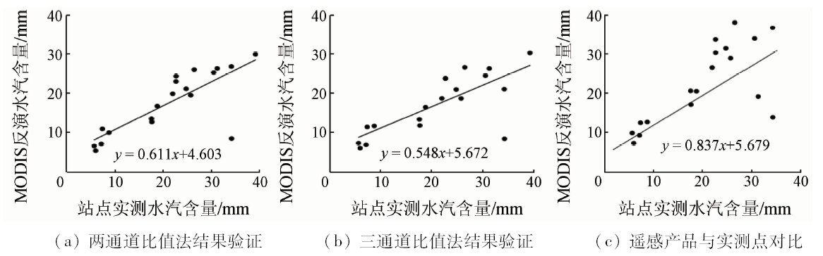
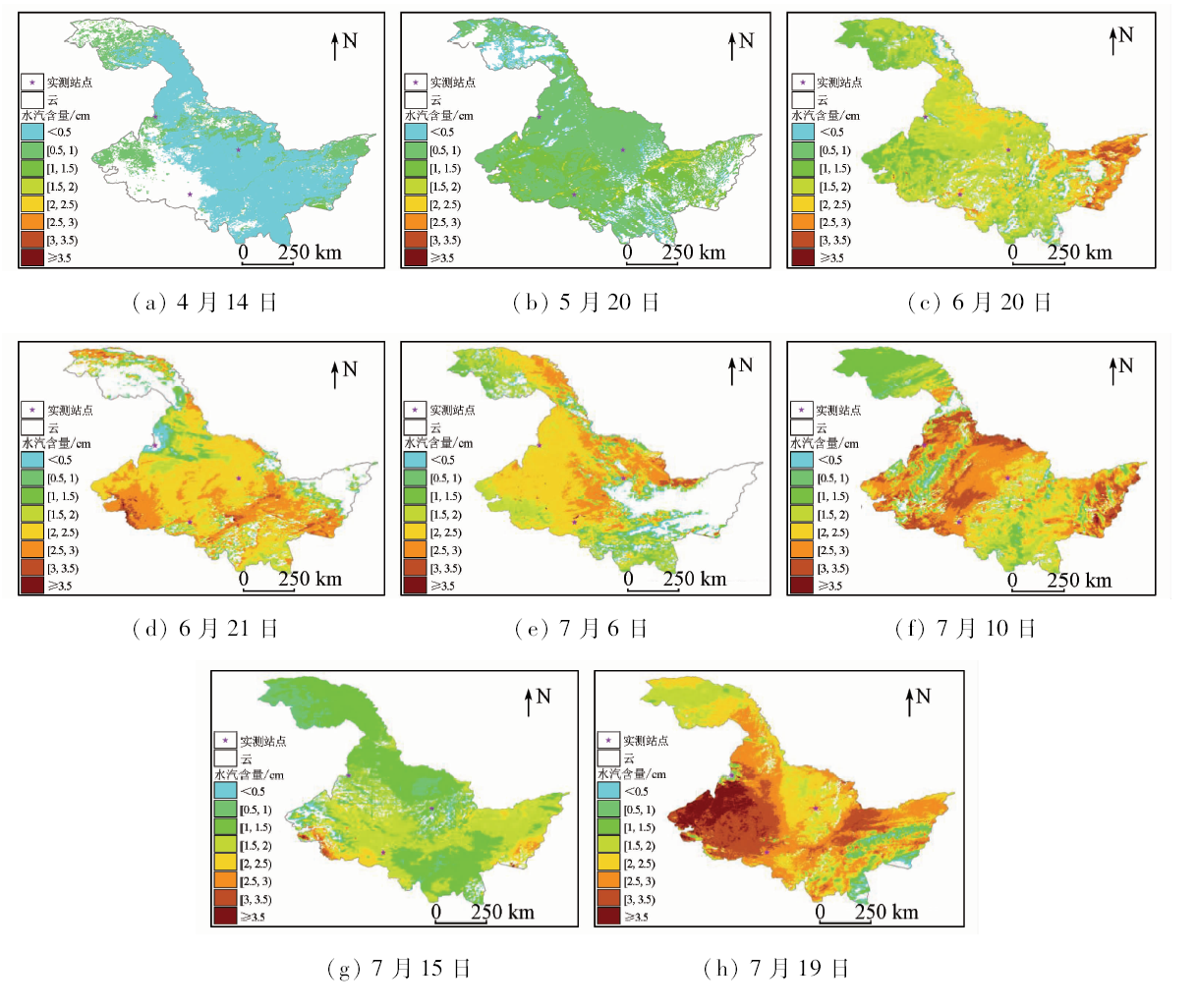
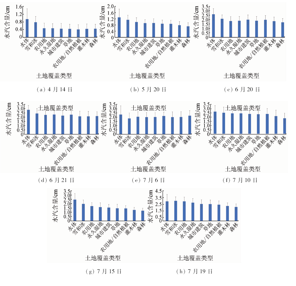
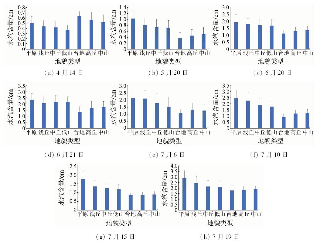
Abstract Atmospheric water vapor content plays an important role in the water cycle between sea and land as well as the formation of aerosol and cloud. Therefore, it is crucial to investigate its spatial-temporal change and influence factors. However, the impact of land use and landform types on it still needs further study. In this paper, the authors selected Heilongjiang Province as the study area, and used two - channel and three - channel ratio methods to retrieve the atmospheric water vapor content and validate the retrieval precision based on MODIS data and sounding real-measure data. Then, the authors analyzed its spatial-temporal change and the relationships between land use types, landform types and atmospheric water vapor content. Some conclusions have been reached: ①The performance of two-channel approach is better than that of three-channel approach; ②The water vapor content in the northwestern and southeastern of Heilongjiang Province is low, but it is higher in the eastern and western parts from April to July; ③The atmospheric water vapor content presents a rising trend in its totality; ④The impacts of land use types and landform types on water vapor content are obvious.
|
| Keywords
channel ratio method
water vapor content
land use type
landform
|
|
|
|
Corresponding Authors:
Guosheng LI
E-mail: ligs@igsnrr.ac.ch
|
|
Issue Date: 15 March 2019
|
|
|
| [1] |
Kaufman Y J, Gao B C . Remote sensing of water vapor in the near IR from EOS/MODIS[J]. IEEE Transactions on Geoscience and Remote Sensing, 1992,30(5):871-884.
doi: 10.1109/36.175321
url: http://ieeexplore.ieee.org/document/175321/
|
| [2] |
李建国, 毛节泰, 李成才 , 等. 使用全球定位系统遥感水汽分布原理和中国东部地区加权“平均温度”的回归分析[J]. 气象学报, 1999,57(3):283-292.
doi: 10.11676/qxxb1999.027
url: http://www.cnki.com.cn/Article/CJFDTotal-QXXB903.002.htm
|
| [2] |
Li J G, Mao J T, Li C C , et al. The approach to remote sensing of water vapor based on GPS and linear regression Tm in eastern region of China[J]. Acta Meteorologica Sinica, 1999,57(3):283-292.
|
| [3] |
谢坤, 任雪娟 . 华北夏季大气水汽输送特征及其与夏季旱涝的关系[J]. 气象科学, 2008,28(5):508-514.
doi: 10.3969/j.issn.1009-0827.2008.05.006
url: http://www.cqvip.com/Main/Detail.aspx?id=28657422
|
| [3] |
Xie K, Ren X J . Climatological characteristics of atmospheric water vapor transport and its relation with rainfall over north China in summer[J]. Scientia Meteorologica Snica, 2008,28(5):508-514.
|
| [4] |
万蓉, 郑国光, 于胜杰 , 等. 基于观测约束的地基GPS三维水汽层析技术研究[J]. 气象学报, 2013,71(2):318-331.
doi: 10.11676/qxxb2013.026
url: http://d.wanfangdata.com.cn/Periodical/qxxb201302012
|
| [4] |
Wang R, Zheng G G, Yu S J , et al. A study of the ground-based GPS 3D water vapor tomography with radiosonde vertical constracting[J]. Acta Meteorologica Sinica, 2013,71(2):318-331.
|
| [5] |
刘安伟, 刘良云, 张浩 , 等. 基于Hyperion影像的高光谱水汽含量反演的算法比较研究[J]. 遥感技术与应用, 2016,31(4):672-681.
doi: 10.11873/j.issn.1004-0323.2016.4.0672
url: http://www.cnki.com.cn/Article/CJFDTotal-YGJS201604007.htm
|
| [5] |
Liu A W, Liu L Y, Zhang H , et al. Comparative study of the algorithm on hyperspectral inversion of the water-vapor content based on Hyperion image[J]. Remote Sensing Technology and Application, 2016,31(4):672-681.
|
| [6] |
Ji D, Shi J . Water vapor retrieval over cloud cover area on land using AMSR-E and MODIS[J]. IEEE Journal of Selected Topics in Applied Earth Observations and Remote Sensing, 2014,7(7):3105-3116.
doi: 10.1109/JSTARS.2014.2298979
url: http://ieeexplore.ieee.org/document/6727448/
|
| [7] |
黄意玢, 董超华 . 用940 nm通道遥感水汽总量的可行性试验[J]. 应用气象学报, 2002,13(2):184-192.
doi: 10.3969/j.issn.1001-7313.2002.02.007
url: http://www.cnki.com.cn/Article/CJFDTotal-YYQX200202006.htm
|
| [7] |
Huang Y B, Dong C H . Feasibility experiments on sounding water vapor amount with 940 nm spectral band[J]. Journal of Applied Meteorological Science, 2002,13(2):3105-3116.
|
| [8] |
毛克彪, 覃志豪 . 用MODIS影像反演环渤海地区的大气水汽含量[J]. 遥感信息, 2004,4:47-49.
doi: 10.3969/j.issn.1000-3177.2004.04.014
url: http://www.cnki.com.cn/Article/CJFDTotal-YGXX200404016.htm
|
| [8] |
Mao K B, Qin Z H . Retrieval of water content of atmosphere in Bohai Region by MODIS image[J]. Remote Sensing Information, 2004,4:47-49.
|
| [9] |
宋正方, 魏合理, 吴晓庆 . 大气水汽的红外遥感[J]. 环境遥感, 1996,11(2):130-137.
url: http://www.cnki.com.cn/Article/CJFDTotal-YGXB602.006.htm
|
| [9] |
Song Z F, Wei H L, Wu X Q . Infrared remote sensing of atmospheric water vapor[J]. Remote Sensing of Environment China, 1996,11(2):130-137.
|
| [10] |
胡秀清, 张玉香, 黄意玢 , 等. 利用太阳辐射计940 nm通道反演大气柱水汽总量[J]. 气象科技, 2001,29(3):12-17.
doi: 10.3969/j.issn.1671-6345.2001.03.002
url: http://d.wanfangdata.com.cn/Periodical/qxkj200103002
|
| [10] |
Hu X Q, Zhang Y X, Huang Y B , et al. Total column water vapor retrievals using 940 nm band of sun photometer[J]. Meteorological Science and Technology, 2001,29(3):12-17.
|
| [11] |
谷晓平, 王新明, 吴战平 , 等. 基于MODIS近红外数据的贵州高原大气水汽反演研究[J]. 高原气象, 2009,28(2):446-451.
doi:
url: http://www.cqvip.com/qk/91655X/200902/30516442.html
|
| [11] |
Gu X P, Wang X M, Wu Z P , et al. Retrieval of atmospheric water vapor using MODIS near infrared channel data in Guizhou Plateau[J]. Plateau Meteorology, 2009,28(2):446-451.
|
| [12] |
胡秀清, 黄意玢, 陆其峰 , 等. 利用FY-3A近红外资料反演水汽总量[J]. 应用气象学报, 2011,22(1):46-56.
doi: 10.11898/1001-7313.20110105
url: http://www.cqvip.com/Main/Detail.aspx?id=37086282
|
| [12] |
Hu X Q, Huang Y B, Lu Q F , et al. Retrieving precipitable water vapor based on the near-infrared data of FY-3A satellite[J]. Journal of Applied Meteorological Science, 2011,22(1):46-56.
|
| [13] |
Bennouna Y S, Torres B , et al. The evaluation of the integrated water vapour annual cycle over the Iberian Peninsula from EOS-MODIS against different ground-based techniques[J]. Quarterly Journal of the Royal Meteorological Society, 2013,139:1935-1955.
doi: 10.1002/qj.2080
url: http://doi.wiley.com/10.1002/qj.2080
|
| [14] |
Mina M, Mehdi M, Mohammad R S . Estimation and validation of atmospheric water vapor content using a MODIS NIR band ratio technique based on AIRS water vapor products[J]. Arabian Journal of Geosciences, 2014,7:1891-1897.
doi: 10.1007/s12517-013-0828-2
url: http://link.springer.com/10.1007/s12517-013-0828-2
|
| [15] |
Chrysoulakis N, Kamarianakis Y, Xu L , et al. Combined use of AIRS,AVHRR and radiosonde data for the estimation of spatio-temporal distribution of perceptible water[J]. Journal of Geophysical Research, 2008,113(5):1-18.
doi: 10.1029/2007JD009255
url: http://onlinelibrary.wiley.com/doi/10.1029/2007JD009255/pdf
|
| [16] |
于秀丽 . 基于MODIS数据的大气水汽含量变化分析[D]. 武汉:湖北工业大学, 2015.
|
| [16] |
Yu X L . Analysis of Atmospheric Precipitable Water Vapor Change Based on MODIS Data[D]. Wuhan:Hubei University of Technology, 2015.
|
| [17] |
陶玮, 刘峻峰, 陶澍 . 城市化过程中下垫面改变对大气环境的影响[J]. 热带地理, 2014,34(3):283-292.
url: http://d.wanfangdata.com.cn/Periodical/rddl201403002
|
| [17] |
Tao W, Liu J F, Tao S . Effects of urban underlying surface change on ambient atmospheric environment[J]. Tropical Geography, 2014,34(3):283-292.
|
| [18] |
吴俊杰, 宋开山, 刘志明 , 等. 基于MODIS数据的东北地区水汽含量反演[J]. 中国农业气象, 2010,31(3):447-452.
doi: 10.3969/j.issn.1000-6362.2010.03.023
url: http://www.cqvip.com/Main/Detail.aspx?id=34898387
|
| [18] |
Wu J J, Song K S, Liu Z M , et al. MODIS-based retrieval of atmospheric water vapor content in northeast China[J]. Chinese Journal of Agrometeorology, 2010,31(3):447-452.
|
| [19] |
Giglio L, Descloitres J, Justice C O , et al. An enhanced contextual fire detection algorithm for MODIS[J]. Remote Sensing of Environment, 2003,87(2-3):273-282.
doi: 10.1016/S0034-4257(03)00184-6
url: https://linkinghub.elsevier.com/retrieve/pii/S0034425703001846
|
| [20] |
姜立鹏, 覃志豪, 谢雯 . 针对MODIS近红外数据反演大气水汽含量研究[J]. 国土资源遥感, 2006,18(3):5-9.doi: 10.6046/gtzyyg.2006.03.02.
doi: 10.6046/gtzyyg.2006.03.02
url: http://d.wanfangdata.com.cn/Periodical/gtzyyg200603002
|
| [20] |
Jiang L P, Qin Z H, Xie W . Retrieving atmospheric water vapor from MODIS near infrared data[J]. Remote Sensing for Land and Resources, 2006,18(3):5-9.doi: 10.6046/gtzyyg.2006.03.02.
|
| [21] |
Gao B C ,Geotz A F H.Column atmospheric water vapor and vegetation liquid water retrievals from airborne imaging spectrometer data[J]. Journal of Geophysical Research, 1990,95(4):3549-3564.
doi: 10.1029/JD095iD04p03549
url: http://doi.wiley.com/10.1029/JD095iD04p03549
|
| [22] |
王妍 . 基于DEM地形信息提取与景观空间格局分析[D]. 重庆:西南大学, 2006.
|
| [22] |
Wang Y . Landform Information Obtains and Landscape Spatial Pattern Analysis based on DEM[D]. Chongqing:Southwest University, 2006.
|
| [23] |
李秀芬, 郑有飞, 于瑛楠 , 等. 基于MODIS数据的黑龙江省大气水汽含量反演[J]. 中国农业气象, 2008,29(2):205-207.
doi: 10.3969/j.issn.1000-6362.2008.02.023
url: http://d.wanfangdata.com.cn/Periodical/zgnyqx200802023
|
| [23] |
Li X F, Zheng Y F, Yu Y N , et al. Retrieval of vapor content of atmosphere based on MODIS data in Heilongjiang Province[J]. Chinese Journal of Agrometeorology, 2008,29(2):205-207.
|
| [24] |
翟墨, 原帅 . 基于EOS/MODIS的黑龙江省大气可降水量反演方法研究[J]. 黑龙江气象, 2016,33(3):20-22.
url: http://www.cnki.com.cn/Article/CJFDTotal-HLJQ201603008.htm
|
| [24] |
Zhai M, Yuan S . Analysis of EOS/MODIS-based method for retrieving precipitable water over Heilongjiang Province[J]. Heilongjiang Meteorology, 2016,33(3):20-22.
|
| [25] |
刘玉洁, 杨忠东 . MODIS遥感信息处理原理与算法[M]. 北京: 科学出版社, 2000.
|
| [25] |
Liu Y J, Yang Z D. The Theories and Algorithms for MODIS Data Processing[M]. Beijing: Science Press, 2000.
|
| [26] |
中国天气网.2015年7月气候影响评价[EB/OL].[ 2015- 08- 03]. .
url: http://www.weather.com.cn/heilongjiang/qxfw/qhfwcp/yqhyxpj/08/2366380.shtml
|
| [26] |
Weather China.Assessment of climate impact in July 2015[EB/OL].[ 2015- 08- 03]. .
url: http://www.weather.com.cn/heilongjiang/qxfw/qhfwcp/yqhyxpj/08/2366380.shtml
|
| [27] |
孟宪红, 吕世华, 张宇 , 等. 基于MODIS数据的金塔绿洲上空水汽含量反演研究[J]. 水科学进展, 2007,18(2):264-269.
doi: 10.3321/j.issn:1001-6791.2007.02.019
url: http://d.wanfangdata.com.cn/Periodical_skxjz200702019.aspx
|
| [27] |
Meng X H, Lyu S H, Zhang Y , et al. MODIS-based reversion of atmospheric water vapor content over Jinta Oasis[J]. Advances in Water Science, 2007,18(2):264-269.
|
|
Viewed |
|
|
|
Full text
|
|
|
|
|
Abstract
|
|
|
|
|
Cited |
|
|
|
|
| |
Shared |
|
|
|
|
| |
Discussed |
|
|
|
|
 2019,
Vol. 31
2019,
Vol. 31