|
|
 |
|

|
|
|
Characteristics of land subsidence along Beijing-Tianjin inter-city railway (Beijing section) |
Xiaojing ZHANG1,2, Beibei CHEN1,2( ), Kunchao LEI3, Wenfeng CHEN1,2, Mingliang GAO1,2, Chaofan ZHOU1,2, Guangyao DUAN4 ), Kunchao LEI3, Wenfeng CHEN1,2, Mingliang GAO1,2, Chaofan ZHOU1,2, Guangyao DUAN4 |
1.Key Lab of 3D Information Acquisition and Application, Ministry of Education, Beijing 100048, China
2.State Key Laboratory Breeding Base of Process of Urban Environment and Digital Simulation, Beijing 100048, China
3.Beijing Institute of Hydrogeology and Engineering Geology, Beijing 100195, China
4.School of Geology and Geomatics, Tianjin Chengjian University, Tianjin 300384, China |
|
|
|
|
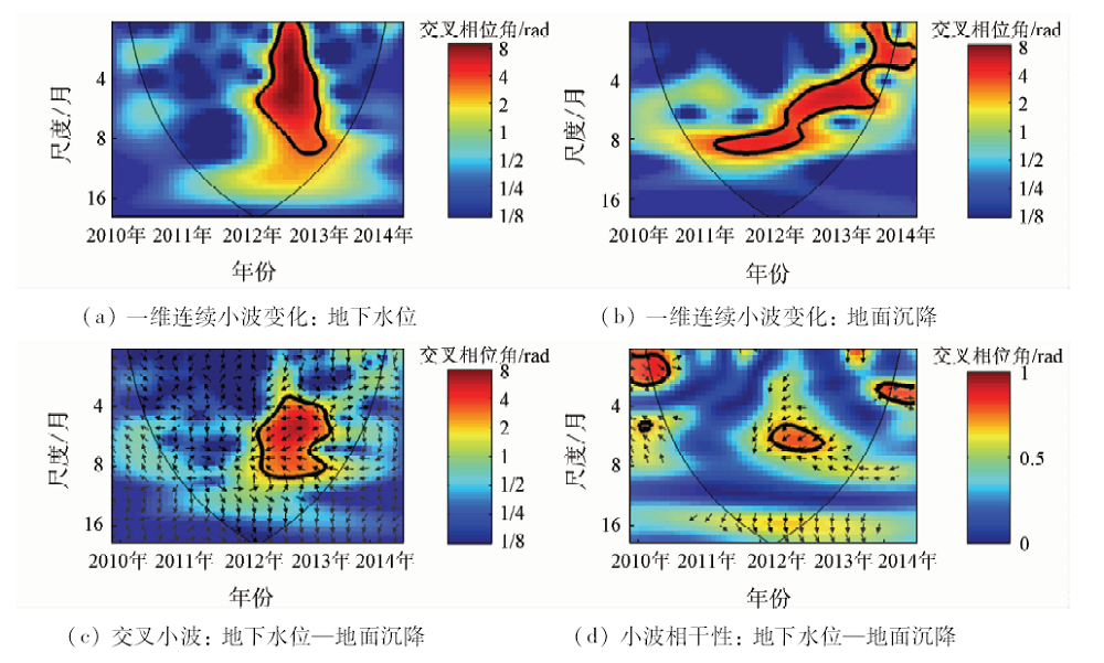
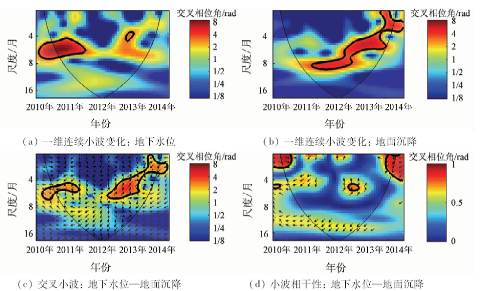
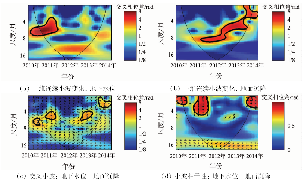
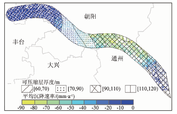
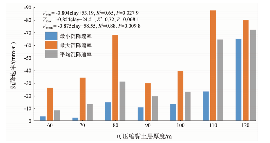
Abstract In this paper, according to the land subsidence problem existing in the Beijing-Tianjin inter-city railway (Beijing section), time-series synthetic aperture Radar interferometry was used to obtain the land subsidence information from 2010 to 2015. Combined with the measured data of groundwater, the relationship between the groundwater level changes and the land subsidence at different layers was studied by using the cross wavelet method. Finally, the relationship between land subsidence and compressible clay thickness was analyzed based on the distribution of compressible clay in the study area. The result showed that average annual maximum sedimentation rate in the study area was 121mm/a, that the ground subsidence lagged the pressure level of the pressure level by 910 months, with the lag time of the submersible being 4 months, and that the ground subsidence rate in the control range of the same flushing fan increased with the thickness of compressible clay layer. This research is of great significance for the scientific effective prevention and control of uneven ground settlement on linear ground objects.
|
| Keywords
Beijing Tianjin inter-city railway (BTIR)
land subsidence
groundwater
lagging behind
compressible layer
|
|
|
|
Corresponding Authors:
Beibei CHEN
E-mail: cnucbb@yeah.net
|
|
Issue Date: 14 March 2019
|
|
|
| [1] |
汪珊, 张彤, 黄大英 , 等. 北京市地下水合理开发与保护[C]// 地下水开发利用与污染防治技术专刊. 2009: 52-56.
|
| [1] |
Wang S, Zhang T, Huang D Y , et al. The rational utlization and protection of groundwater in Beijing[C]// Special Issue of Groundwater Development and Utilization and Pollution Control Technology, 2009: 52-56.
|
| [2] |
Yang Y, Jia S . Situation and countermeasures of prevention & control on land subsidence in Beijing[J]. Urban Geology, 2013,8(4):6-10.
|
| [3] |
Duan G Y, Gong H L, Liu H H , et al. Monitoring and analysis of land subsidence along Beijing-Tianjin inter-city railway[J]. Journal of the Indian Society of Remote Sensing, 2016,44(6):1-17.
doi: 10.1007/s12524-015-0448-2
url: http://link.springer.com/10.1007/s12524-015-0448-2
|
| [4] |
袁怀宇 . 公路工程中沉降板的应用[J]. 东北公路, 2003,26(2):79-80.
url: http://www.cnki.com.cn/Article/CJFDTotal-DBGL200302029.htm
|
| [4] |
Yuan H Y . Settlement plate employing in highway engineering[J]. Northeastern Highway, 2003,26(2):79-80.
|
| [5] |
花梅 . 高速铁路路基常用沉降变形监测方法浅析[J]. 铁道标准设计, 2014,58(s1):122-125.
doi: 10.13238/j.issn.1004-2954.2014.S.036
url: http://www.cnki.com.cn/Article/CJFDTotal-TDBS2014S1037.htm
|
| [5] |
Hua M . Analysis of common settlement deformation monitoring methods for subgrade of high speed railway[J]. Railway Standard Design, 2014,58(s1):122-125.
|
| [6] |
Tarchi D, Rudolf H, Luzi G, et al. SAR interferometry for structural changes detection:A demonstration test on a dam[C]// Internationl Geoscience and Remote Sensing Symposium.IEEE, 1999.
|
| [7] |
Ge D Q, Zhang L, Wang Y, et al. Merging multi-track PSI result for land subsidence mapping over very extended area[C]// International Geoscience and Remote Sensing Symposium.IEEE, 2010: 3522-3525.
|
| [8] |
冷长明 . 高速铁路地基不均匀沉降的因素及机理分析[J]. 高速铁路技术, 2011,2(3):5-8.
doi: 10.3969/j.issn.1674-8247.2011.03.002
url: http://d.wanfangdata.com.cn/Periodical/gstljs201103002
|
| [8] |
Leng C M . Analysis of the factor and mechanism of uneven settlement of high-speed raiway subgrade[J]. High Speed Railway Technology, 2011,2(3):5-8.
|
| [9] |
高亮, 赵磊, 曲村 , 等. 路基上CRTSⅢ型板式无砟轨道设计方案比较分析[J]. 同济大学学报(自然科学版), 2013,41(6):848-855.
doi: 10.3969/j.issn.0253-374x.2013.06.008
url: http://www.cnki.com.cn/Article/CJFDTotal-TJDZ201306010.htm
|
| [9] |
Gao L, Zhao L, Qu C , et al. Analysis on design scheme of CRTSⅢ slab track structure on road[J]. Journal of Tongji University (Natural Science), 2013,41(6):848-855.
|
| [10] |
刘晓龙, 张永红, 李英会 , 等, 基于时间序列TerraSAR-X影像的线状地物沉降监测试验研究[J]. 遥感信息, 2013,28(4):57-62.
doi: 10.3969/j.issn.1000-3177.2013.04.010
url: http://d.wanfangdata.com.cn/Periodical/ygxx201304010
|
| [10] |
Liu X L, Zhang Y H, Li Y H , et al. Exploration of subsidence along linear engineering structures on time series of TerraSAR-X images[J]. Remote Sensing Information, 2013,28(4):57-62.
|
| [11] |
王荣, 杨艳, 田芳 , 等. 高速铁路区域地面沉降监测体系构建[J]. 上海国土资源, 2014,35(2):17-20.
doi: 10.3969/j.issn.2095-1329.2014.02.005
url: http://www.cnki.com.cn/Article/CJFDTotal-SHAD201402005.htm
|
| [11] |
Wang R, Yang Y, Tian F , et al. Construction of a monitoring system for regional land subsidence affecting high-speed railways[J]. Shanghai Land and Resources, 2014,35(2):17-20.
|
| [12] |
贾三满, 王海刚, 赵守生 , 等. 北京地面沉降机理研究初探[J]. 城市地质, 2007,2(1):20-26.
doi: 10.3969/j.issn.1007-1903.2007.01.005
url: http://www.cnki.com.cn/Article/CJFDTotal-CSDZ200701005.htm
|
| [12] |
Jia S M, Wang H G, Zhao S H , et al. A tentative study of the mechanism of land subsidence in Beijing[J]. City Geology, 2007,2(1):20-26.
|
| [13] |
陈蓓蓓 . 北京市典型地区地面沉降演化过程与机理分析[M]. 北京: 中国环境出版社, 2015.
|
| [13] |
Chen B B. The Evolution Process and Mechanism of Land Subsidence in Typical Area,Beijing[M]. Beijing: China Environmental Science Press, 2015.
|
| [14] |
Hooper A J . Persistent Scatter Radar Interferometry for Crustal Deformation Studies and Modeling of Volcanic Deformation[D]. Stanford:Stanford University, 2006.
|
| [15] |
刘一霖, 张勤, 黄海军 , 等. 矿区地表大量级沉陷形变短基线集InSAR监测分析[J]. 国土资源遥感, 2017,29(2):144-151.doi: 10.6046/gtzyyg.2017.02.21.
doi: 10.6046/gtzyyg.2017.02.21
url: http://www.cnki.com.cn/Article/CJFDTOTAL-GTYG201702021.htm
|
| [15] |
Liu Y L, Zhang Q, Huang H J , et al. Monitoring and analysis large scale land subsidence over the mining area using small baseline subset InSAR[J]. Remote Sensing for Land and Resources, 2017,29(2):144-151.doi: 10.6046/gtzyyg.2017.02.21.
|
| [16] |
刘志敏, 李永生, 张景发 , 等. 基于SBAS-InSAR的长治矿区地表形变监测[J]. 国土资源遥感, 2014,26(3):37-42.doi: 10.6046/gtzyyg.2014.03.06.
doi: 10.6046/gtzyyg.2014.03.06
url: http://d.old.wanfangdata.com.cn/Periodical/gtzyyg201403008
|
| [16] |
Liu Z M, Li Y S, Zhang J F et al. An analysis of surface deformation in the Changzhi mining area using small baseline InSAR[J]. Remote Sensing for Land and Resources, 2014,26(3):37-42.doi: 10.6046/gtzyyg.2014.03.06.
|
| [17] |
王文圣, 丁晶, 向红莲 . 小波分析在水文学中的应用研究及展望[J]. 水科学进展, 2002,13(4):515-520.
doi: 10.3321/j.issn:1001-6791.2002.04.021
url: http://www.cqvip.com/Main/Detail.aspx?id=6594211
|
| [17] |
Wang W S, Ding J, Xiang H L . Application and prospect of wavelet analysis in hydrology[J]. Advances in Water Science, 2002,13(4):515-520.
|
| [18] |
郭良迁, 薄万举, 杨国华 . 华北地区断裂带的现代形变特征[J]. 大地测量与地球动力学, 2003,23(2):29-36.
doi: 10.3969/j.issn.1671-5942.2003.02.005
url: http://d.wanfangdata.com.cn/Periodical/dkxbydz200302005
|
| [18] |
Guo L Q, Bo W J, Yang G H . Characteristics of current deformation of fault beltisin north China[J]. Journal of Geodesy and Geodynamics, 2003,23(2):29-36.
|
| [19] |
林健 . 北京市城近郊区地下水污染演变分析研究[D]. 长春:吉林大学, 2004.
|
| [19] |
Lin J . The Analysis of Pollution History for the Groundwater in Urban and Suburb Area of Beijing[D]. Changchun: Jilin University, 2004.
|
| [20] |
罗勇 . 北京地面沉降发展新趋势初步分析[J]. 上海国土资源, 2017,38(2):13-17.
doi: 10.3969/j.issn.2095-1329.2017.02.004
url: http://d.wanfangdata.com.cn/Periodical/shdz201702004
|
| [20] |
Luo Y . Research on the new trends of Beijing land subsidence[J]. Shanghai Land and Resources, 2017,38(2):13-17.
|
| [21] |
Grinsted A, Moore J C, Jevrejeva S . Application of the cross wavelet transform and wavelet coherence to geophysical time series[J]. Nonlinear Processes in Geophysics, 2004,11(5/6):561-566.
doi: 10.5194/npg-11-561-2004
url: http://www.nonlin-processes-geophys.net/11/561/2004/
|
| [22] |
姜媛, 杨艳, 王海刚 , 等. 北京平原区地面沉降的控制与影响因素[J]. 上海国土资源, 2014,26(4):130-133.
doi: 10.3969/j.issn.2095-1329.2014.04.031
url: http://www.cnki.com.cn/Article/CJFDTotal-SHAD201404033.htm
|
| [22] |
Jiang Y, Yang Y, Wang H G , et al. Factors controlling land subsidence on the Beijing plain[J]. Shanghai Land and Resources. 2014,26(4):130-133.
|
|
Viewed |
|
|
|
Full text
|
|
|
|
|
Abstract
|
|
|
|
|
Cited |
|
|
|
|
| |
Shared |
|
|
|
|
| |
Discussed |
|
|
|
|
 2019,
Vol. 31
2019,
Vol. 31