|
|
 |
|

|
|
|
Research on temporal and spatial evolution law of land subsidence in Zhengzhou |
WANG Baocun1( ), ZHU Lin1, PAN Deng2, GUO Lingfei1, PENG Peng3 ), ZHU Lin1, PAN Deng2, GUO Lingfei1, PENG Peng3 |
1. Institute of Surveying, Mapping and Geoinformation of Henan Provincial Bureau of Geo-Exploration and Mineral Development,Zhengzhou 450000, China
2. Henan Geo-Environmental Monitoring Institute, Zhengzhou 450016, China,Zhengzhou 450000, China
3. Geological Survey of Anhui Province, Hefei 230001, China |
|
|
|
|
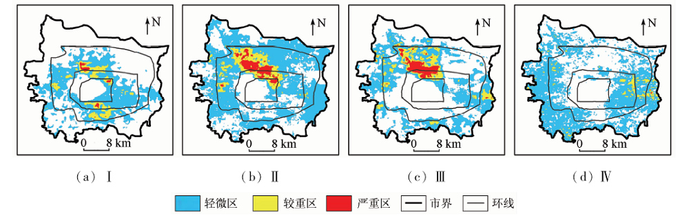
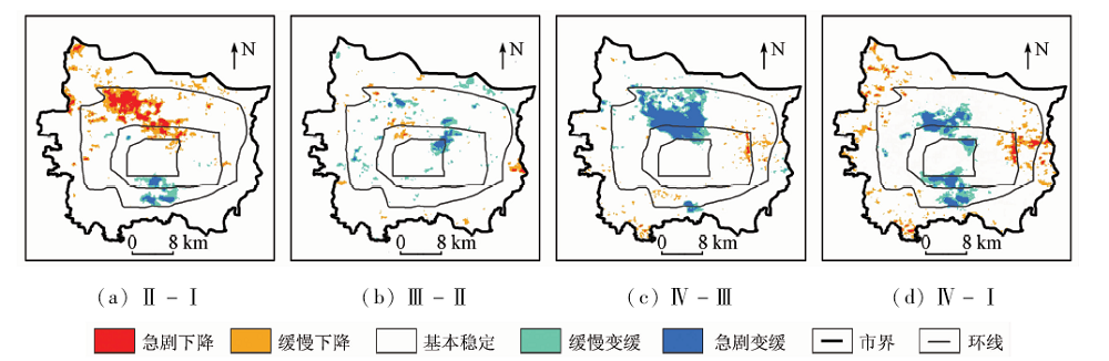
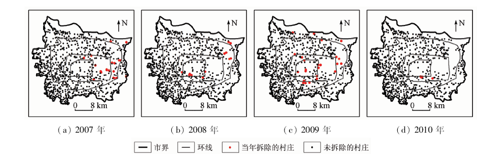
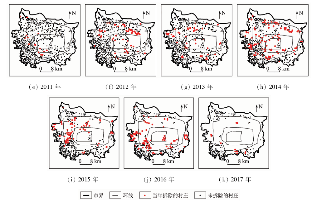
Abstract The monitoring results in recent years show that land subsidence in Zhengzhou has been developed rapidly. In order to find out the evolution law of Zhengzhou’s land subsidence and serve the prevention and control work of urban land subsidence, the authors selected the synthetic aperture Radar(SAR) data in recent years (2007—2017), compiled the land subsidence distribution maps of Zhengzhou in four periods of 2007—2010, 2012—2013, 2013—2016 and 2016—2017 by combining with the bench-mark monitoring results, and analyzed the evolution law of Zhengzhou’s land subsidence from time and space. By the GIS room analysis method, the authors studied the space-time response relation between land subsidence and urban village evolution in recent years. Research results show that the urban village is the predominant factor in the land subsidence evolution of Zhengzhou, namely, the groundwater abstraction in urban village causes land subsidence; the relocation of urban village and reduction of groundwater abstraction cause slow land subsidence and even uplift of land subsidence; the relocation causes the floating population to move to outer suburbs, which forms a new floating population and industrial accumulation area, and further forms a new ground subsidence area.
|
| Keywords
SAR
land subsidence
evolution law
urban village
|
|
|
|
Issue Date: 09 October 2020
|
|
|
| [1] |
吴建中. 中国地面沉降地质灾害区划方法与实践[J].上海国土资源, 2011(2):84-87.
|
| [1] |
Wu J Z. Method and application of land subsidence disaster regionalization[J].Shanghai Land & Resources 2011(2):84-87.
|
| [2] |
张永红, 吴宏安, 康永辉. 京津冀地区1992—2014年三阶段地面沉降InSAR监测[J]. 测绘学报, 2016,45(9):1050-1058.
|
| [2] |
Zhang Y H, Wu H A, Kang Y H. Ground subsidence over Beijing-Tianjin-Hebei region during three periods of 1992 to 2014 monitored by interferometric SAR[J]. Acta Geodateica et Cartographica Sinica, 2016,45(9):1050-1058.
|
| [3] |
田芳, 罗勇, 周毅, 等. 北京地面沉降与地下水开采时空演变对比[J]. 南水北调与水利科技, 2017,15(2):163-169.
|
| [3] |
Tian F, Luo Y, Zhou Y, et al. Contrastive analysis of spatial-temporal evolution between land subsidence and groundwater exploitation in Beijing[J]. South-to-North Water Transfers and Water Science & Technology, 2017,15(2):163-169.
|
| [4] |
葛大庆, 张玲, 王艳, 等. 上海地铁10号线建设与运营过程中地面沉降效应的高分辨率InSAR监测及分析[J].上海国土资源, 2014(4):62-67.
|
| [4] |
Ge D Q, Zhang L, Wang Y, et al. Monitoring subsidence on Shanghai metro line 10 during construction and operation using high-resolution InSAR[J].Shanghai Land & Resources 2014(4):62-67.
|
| [5] |
范景辉, 李梅, 郭小方, 等. 基于PSInSAR方法和ASAR数据监测天津地面沉降的试验研究[J]. 国土资源遥感, 2007,19(4):23-27.doi: 10.6046/gtzyyg.2007.04.05.
|
| [5] |
Fan J H, Li M, Guo X F, et al. A preliminary study of the subsidence in Tianjin area using ASAR images based on PSInSAR technique[J]. Remote Sensing for Land and Resources, 2007,19(4):23-27.doi: 10.6046/gtzyyg.2007.04.05.
|
| [6] |
郭新华, 李建欣. 开展郑州市地面沉降监测工作的必要性[J], 中国地质灾害与防治学报, 2007,18(1):147-148.
|
| [6] |
Guo X H, Li J X. The necessity of land subsidence monitoring in Zhengzhou[J]. The Chinese Journal of Geological Hazard and Control, 2007,18(1):147-148.
|
| [7] |
汪宝存, 李芳芳, 潘登, 等. PS-InSAR技术在郑州市地面沉降调查中的应用[J]. 测绘科学, 2013,38(5):43-45.
|
| [7] |
Wang B C, Li F F, Pan D, et al. Application of PS-InSAR technology in land subsidence investigation of Zhengzhou[J]. Science of Surveying and Mapping, 2013,38(5):43-45.
|
| [8] |
王义梅, 罗小军, 于冰, 等. 郑州市地面沉降InSAR监测[J]. 测绘科学, 2019,44(9):100-106.
|
| [8] |
Wang Y M, Luo X J, Yu B, et al. Monitoring ground subsidence in Zhengzhou with InSAR[J]. Science of Surveying and Mapping, 2019,44(9):100-106.
|
| [9] |
管力, 唐伟, 戴华阳, 等. 采用SBAS-InSAR技术监测郑州城区地面沉降[J]. 北京测绘, 2019,33(4):462-467.
|
| [9] |
Guan L, Tang W, Dai H Y, et al. Monitoring ground subsidence in Zhengzhou City based on SBAS-InSAR technology[J]. Beijing Surverying and Mapping, 2019,33(4):462-467.
|
| [10] |
夏飞雪, 姚青, 聂明军. 京广高铁郑州段地面沉降原因分析[J]. 地下水, 2014,36(4):97-98.
|
| [10] |
Xia F X, Yao Q, Nie M J. Reason analysis of land subsidence in Zhengzhou section of Beijing Guangzhou high speed railway[J]. Ground Water, 2014,36(4):97-98.
|
| [11] |
詹学启, 张占荣. 郑徐高速铁路郑州段区域地面沉降预测分析[J]. 铁道标准设计, 2014,58(7):56-60.
|
| [11] |
Zhan X Q, Zhang Z R. Prediction and analysis of regional land subsidence in Zhengzhou section of Zheng Xu high speed railway[J]. Railway Standard Design, 2014,58(7):56-60.
|
| [12] |
朱卫民, 汪宝存, 宋会传, 等. 基于InSAR的京广高铁郑州段地面沉降调查与监测[J]. 测绘与空间地理信息, 2019,42(9):61-63.
|
| [12] |
Zhu W M, Wang B C, Song H C, et al. Investination and monitoring of ground subsidence in Zhengzhou section of high-speed railway between Beijing and Guangzhou[J]. Geomatics & Spatial Information Technology, 2019,42(9):61-63.
|
| [13] |
刘勇. 黄河三角洲地区地面沉降时空演变特征及机理研究[D]. 青岛:中国科学院海洋研究所, 2013.
|
| [13] |
Liu Y. Spatiotemporal evolution of land subsidence and mechanism discussion in the Yellow River Delta,China[D].Tsingtao:Institute of Oceanology,Chinese Academy of Science, 2013.
|
| [14] |
刘杰. 郑州市流动人口信息服务与管理研究[D]. 郑州:郑州大学, 2014.
|
| [14] |
Liu J. Zhengzhou City information service and management of the floating population study[D]. Zhengzhou:Zhengzhou University, 2014.
|
| [15] |
王元亮. 郑州城中村改造现状、困境与对策[J]. 现代城市, 2015,10(2):11-14.
|
| [15] |
Wang Y L. The status quo,dilemma,and countermeasure of the reconstruction of urban village in Zhengzhou[J]. Modern City, 2015,10(2):11-14.
|
| [16] |
豆敬峰, 田君慧, 潘登, 等. 郑州市地下水动态监测报告(2007—2017)[R]. 郑州:河南省地质环境监测院, 2017.
|
| [16] |
Dou J F, Tian J H, Pan D, et al. Report on groundwater dynamic monitoring in Zhengzhou(2007—2017)[R].Zhengzhou:Henan Geo-Environmental Monitoring Institute, 2015.
|
|
Viewed |
|
|
|
Full text
|
|
|
|
|
Abstract
|
|
|
|
|
Cited |
|
|
|
|
| |
Shared |
|
|
|
|
| |
Discussed |
|
|
|
|
 2020,
Vol. 32
2020,
Vol. 32