|
|
 |
|

|
|
|
Emerging risks and the prospect of urban underground space security based on InSAR-GRACE satellite under the new hydrological background |
YU Hairuo1,2,3,4,5,6,7( ), GONG Huili1,2,3,4,5,6,7(), CHEN Beibei1,2,3,4,5,6,7, ZHOU Chaofan1,2,3,4,5,6,7 ), GONG Huili1,2,3,4,5,6,7(), CHEN Beibei1,2,3,4,5,6,7, ZHOU Chaofan1,2,3,4,5,6,7 |
1. Beijing Laboratory of Water Resources Security, Capital Normal University, Beijing 100048, China
2. The Key Lab of Resource Environment and GIS of Beijing, Capital Normal University, Beijing 100048, China
3. Base of the State Key Laboratory of Urban Environmental Process and Digital Modeling, Capital Normal University, Beijing 100048, China
4. Key Laboratory of 3D Information Acquisition and Application, Ministry of Education, Capital Normal University, Beijing 100048, China
5. Key Laboratory of Mechanism, Prevention and Mitigation of Land Subsidence, Ministry of Education, Capital Normal University, Beijing 100048, China
6. College of Resource Environment and Tourism, Capital Normal University, Beijing 100048, China
7. Observation and Research Station of Groundwater and Land Subsidence in Beijing-Tianjin-Hebei Plain, Ministry of Natural Resources, Beijing 100048, China |
|
|
|
|
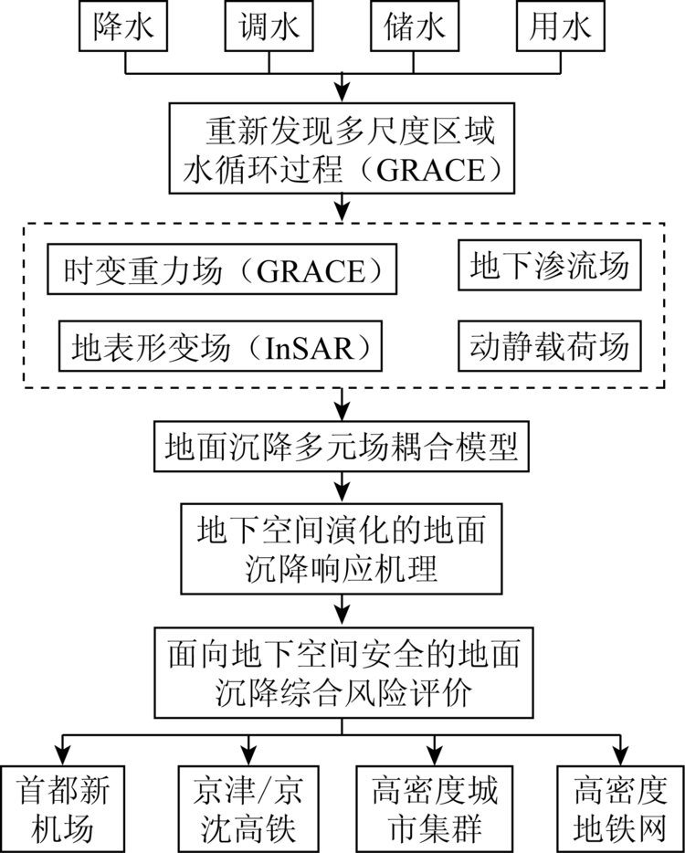
Abstract Regional surface subsidence caused by the development and use of urban underground space is a major hazard endangering the safety of Beijing-Tianjin-Hebei city cluster. This paper briefly reviews the development history of interferometic synthetic aperture Radar (InSAR) technology, systematically summarizes the progress of applying gravity recovery and climate experiment (GRACE) satellite in underground water reserve, illustrates multiple factors containing subsidence, and finally ascribes the subsidence to multiple fields of underground space. Under the new hydrological background of the interaction between South-to-North Water Diversion and mining of underground water, InSAR-GRACE technology is a brand-new means for studying the impact of underground space evolution on land subsidence. Based on InSAR-GRACE technology, this paper rediscovers the regional water circulation laws, quantifies the contribution of multiple fields to subsidence evolution, proposes the surface response research framework for the evolution of underground space, and reveals the formation mechanism on the surface subsidence response model, thereby establishing an emerging risks prevention and control early warning mechanism for underground space security and realizing scientific regulation and control of the region.
|
| Keywords
InSAR-GRACE
underground space evolution
land subsidence response
multiple field interaction
regulation mechanism
|
|
|
|
Corresponding Authors:
GONG Huili
E-mail: 1284869155@qq.com;gonghl@263.net
|
|
Issue Date: 23 December 2020
|
|
|
| [1] |
自然资源部中国地质调查局. 三位一体监测网实时监控华北地面沉降[EB/OL].(2015-04-13)[2019-12-12]. http://www.cgs.gov.cn/xwl/cgkx/201603/t20160309_299270.html.
url: http://www.cgs.gov.cn/xwl/cgkx/201603/t20160309_299270.html
|
| [1] |
China Geological Survey Bureau,Ministry of Natural Resources. Real time monitoring of land subsidence in North China by Trinity monitoring network[EB/OL](2015-04-13)[2019-12-12]. http://www.cgs.gov.cn/xwl/cgkx/201603/t20160309_299270.html.
url: http://www.cgs.gov.cn/xwl/cgkx/201603/t20160309_299270.html
|
| [2] |
Zhang Y Q, Gong H L, Gu Z Q, et al. Characterization of land subsidence induced by ground water withdraws in the plain of Beijing City,China[J]. Hydrogeology Journal, 2014,22(2):397-409
doi: 10.1007/s10040-013-1069-x
url: http://link.springer.com/10.1007/s10040-013-1069-x
|
| [3] |
Ferretti A, Prati C, Rocca F. Nonlinear subsidence rate estimation using permanent scatterers in differential SAR interferometry[J]. IEEE Transactions on Geoscience and Remote Sensing, 2000,38(5):2202-2212.
|
| [4] |
Berardino P, Fornaro G, Lanari R, et al. A new algorithm for surface deformation monitoring based on small baseline differential SAR interferograms[J]. IEEE Transactions on Geoscience and Remote Sensing, 2003,40(11):2375-2383
|
| [5] |
RémI M, Avouac J P, Taboury J. Measuring near field coseismic displacements from SAR images:Application to the Landers earthquake[J]. Geophysical Research Letters, 1999,26(19):3017-3020.
|
| [6] |
Fialko Y A, Rubin A M. Thermal and mechanical aspects of magma emplacement in giant dike swarms[J]. Journal of Geophysical Research, 1999,104(b10):23033.
doi: 10.1029/1999JB900213
url: http://doi.wiley.com/10.1029/1999JB900213
|
| [7] |
Usai S. A least-squares approach for long-term monitoring of deformations with differential SAR interferometry[C]// Geoscience and Remote Sensing Symposium. IEEE, 2002.
|
| [8] |
Wright T J, Parsons B E, Lu Z. Toward mapping surface deformation in three dimensions using InSAR[J]. Geophysical Research Letters, 2004,31(1):L01607.
|
| [9] |
Bechor N B D, Zebker H A. Measuring two-dimensional movements using a single InSAR pair[J]. Geophysical Research Letters, 2006,33(16):L16311.
|
| [10] |
Zhang L, Lu Z, Ding X, et al. Mapping ground surface deformation using temporarily coherent point SAR interferometry:Application to Los Angeles Basin[J]. Remote Sensing of Environment, 2012,117(1):429-439.
|
| [11] |
Ma P, Lin H. Robust detection of single and double persistent scatterers in urban built environments[J]. IEEE Transactions on Geoscience and Remote Sensing, 2016,54(4):2124-2139.
|
| [12] |
Wahr J, Molenaar M, Bryan F. Time variability of the Earth’s gravity field:Hydrological and oceanic effects and their possible detection using GRACE[J]. Journal of Geophysical Research Atmospheres, 1998,103(b12):30205-30229.
|
| [13] |
Tapley B D, Bettadpur S, Ries J C, et al. GRACE measurements of mass variability in the earth system[J]. Science, 2004,305(5683):503-505.
pmid: 15273390
url: https://www.ncbi.nlm.nih.gov/pubmed/15273390
|
| [14] |
Rodell M, Velicogna I, Famiglietti J S. Satellite based estimates of groundwater depletion in India[J]. Nature, 2009,460(7258):999-1002.
doi: 10.1038/nature08238
pmid: 19675570
url: https://www.ncbi.nlm.nih.gov/pubmed/19675570
|
| [15] |
张铁勤, 何祺胜, 荆琛琳, 等. 基于InSAR的北京市平原区地下水动态监测[J]. 科学技术与工程, 2019,19(12):16-22.
|
| [15] |
Zhang T Q, He Q S, Jing C L, et al. Dynamic monitoring of groundwater in the plain area of Beijing based on InSAR[J]. Science Technology and Engineering, 2019,19(12):16-22.
|
| [16] |
宫辉力, 李小娟, 潘云, 等. 京津冀地下水消耗与区域地面沉降演化规律[J]. 中国科学基金, 2017,31(1):72-77.
|
| [16] |
Gong H L, Li X J, Pan Y, et al. Groundwater depletion and regional land subsidence of the Beijing-Tianjin-Hebei area[J]. China Science Foundation, 2017,31(1):72-77.
|
| [17] |
程凌鹏, 范子训, 王新惠, 等. 南水进京后典型区域地下水与地面沉降新动态[J]. 人民黄河, 2018,40(7):82-87.
|
| [17] |
Cheng L P, Fan Z X, Wang X H, et al. New trend of groundwater and land subsidence in typical areas after the south-to-north water transfer into Beijing[J]. Yellow River, 2018,40(7):82-87.
|
| [18] |
王永立. 天津市中心城区地下空间资源评价[J]. 地球科学与环境学报, 2008,30(2):166-171.
|
| [18] |
Wang Y L. Evaluation of underground space resources in downtown Tianjin[J]. Journal of Geosciences and Environment, 2008,30(2):166-171.
|
| [19] |
李永树, 肖林萍. 地面沉降预测参数的变化规律与计算方法[J]. 西南交通大学学报, 2006,41(4):424-428.
|
| [19] |
Li Y S, Xiao L P. Change rule and calculation method of land subsidence prediction parameters[J]. Journal of Southwest Jiaotong University, 2006,41(4):424-428.
|
| [20] |
柳昆, 彭建, 彭芳乐. 地下空间资源开发利用适宜性评价模型[J]. 地下空间与工程学报, 2011,7(2):219-231.
|
| [20] |
Liu K, Peng J, Peng F L. Suitability evaluation model of underground space resources development and utilization[J]. Journal of Underground Space and Engineering, 2011,7(2):219-231.
|
| [21] |
刘健, 魏永耀, 高立. 苏州城市规划区地下空间开发适宜性评价[J]. 地质学刊, 2014,38(1):94-97.
|
| [21] |
Liu J, Wei Y Y, Gao L. Suitability evaluation of underground space development in Suzhou urban planning area[J]. Journal of Geology, 2014,38(1):94-97.
|
| [22] |
胡杨. 国际风险管理理事会(IRGC)2005年北京年会综述[J]. 中国软科学, 2005(10):157-160.
|
| [22] |
Hu Y. Summary of IRGC 2005 Beijing annual meeting[J]. China Soft Science, 2005(10):157-160.
|
| [23] |
王琳, 李迅, 包云轩, 等. 遥感技术在交通气象灾害监测中的应用进展[J]. 国土资源遥感, 2018,30(4):1-7.doi: 10.6046/gtzyyg.2018.04.01.
|
| [23] |
Wang L, Li X, Bao Y X, et al. Research progress of remote sensing application on transportation meteorological disasters[J]. Remote Sensing for Land and Resources, 2018,30(4):1-7.doi: 10.6046/gtzyyg.2018.04.01.
|
|
Viewed |
|
|
|
Full text
|
|
|
|
|
Abstract
|
|
|
|
|
Cited |
|
|
|
|
| |
Shared |
|
|
|
|
| |
Discussed |
|
|
|
|
 2020,
Vol. 32
2020,
Vol. 32