|
|
 |
|

|
|
|
Forest fire potential forecast based on FCCS model |
Zhenyu MA1, Bowei CHEN1, Yong PANG1( ), Shengxi LIAO2, Xianlin QIN1, Huaiqing ZHANG1 ), Shengxi LIAO2, Xianlin QIN1, Huaiqing ZHANG1 |
1. Research Institute of Forest Resource Information Techniques, Chinese Academic of Forestry, Beijing 100091, China
2. Research Institute of Resources Insects, Chinese Academic of Forestry, Kunming 650216, China |
|
|
|
|
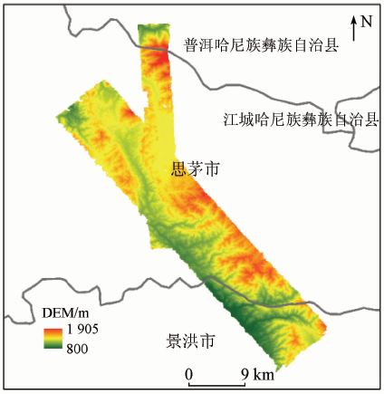
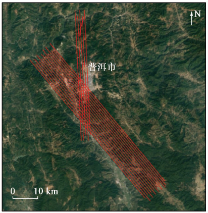
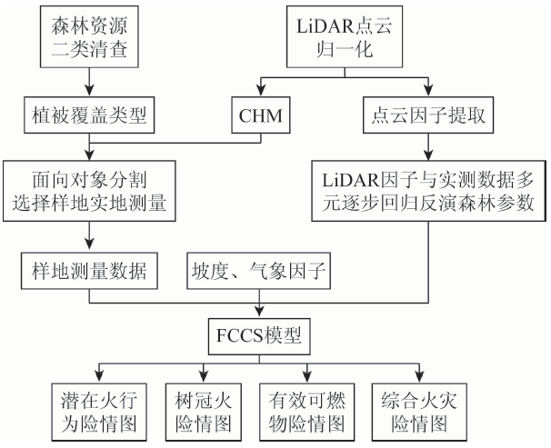
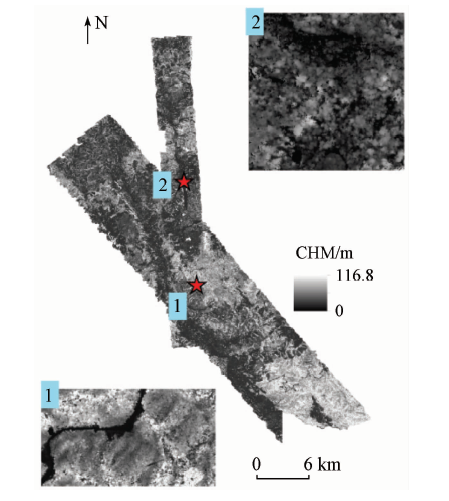
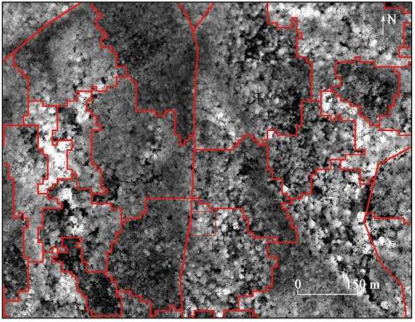
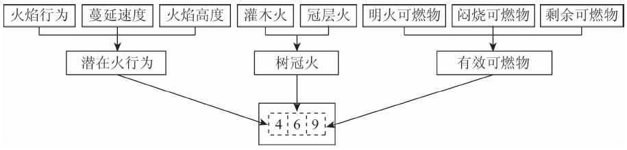
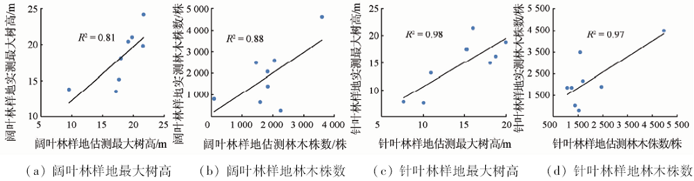
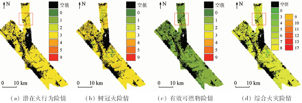
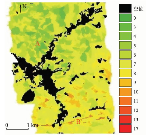
Abstract The distribution of combustibles in forest is one of the important factors that affect the occurrence and spread of forest fires. The purpose of this study is to combine the traditional forest survey data with point cloud data from light laser detection and ranging(LiDAR), slope and meteorological factors so as to evaluate forest fire potentials with fuel characteristic classification system(FCCS). Pu’er City of Yunnan Province was selected as the research area in this paper. An object-oriented based segmentation was performed based on the crown height model(CHM) which was produced by the airborne LiDAR data, and the overlay analysis of the provincial level inventory data of forest resources of the research area was used to determine the division unit and vegetation type according to the flammability of vegetation, which was divided into coniferous forest, broad-leaved forest, shrub and bamboo forest. On such a basis, stratified random sampling was used to form the validation dataset. Then the authors extracted the LiDAR variables and applied the multivariate stepwise regression method to analyzing the extracted variables with the reference data set to obtain the forest parameters of different vegetation types. In the end, the forest parameters together with the meteorological factors were used as inputs to the forest fire classification model (FCCS), and the fire potential of each segmentation unit was calculated by the model. Finally, the authors compiled maps of potential fire behavior, crown fire, effective combustibles and comprehensive fire hazard result. The results showed that the overall fire potential level of combustible materials in the research area is relatively low, which is consistent with the actual situation in the study area; the vertical structure of the forest is closely related to the forest fire risk potentials. Accurate estimation of forest parameters plays a very important role in the mapping of combustibles.
|
| Keywords
LiDAR
forest parameters inversion
FCCS
forest fire potential mapping
|
|
|
|
Corresponding Authors:
Yong PANG
E-mail: pangy@ifrit.ac.cn
|
|
Issue Date: 14 March 2020
|
|
|
| [1] |
Chirici G, Scotti R, Montaghi A , et al. Stochastic gradient boosting classification trees for forest fuel types mapping through airborne laser scanning and IRS LISS-III imagery[J]. International Journal of Applied Earth Observation and Geoinformation, 2013,25(1):87-97.
|
| [2] |
San-Miguel-Ayanz J, Rodrigues M, Oliveira S S D , et al. Land cover change and fire regime in the European Mediterranean region[M] //Moreira F,Arianoutsou M,Corona P,et al.Post-Fire Management and Restoration of Southern European Forests.Springer, 2012: 21-43.
|
| [3] |
Schmidt K M, Menakis J P, Hardy C C , et al. Development of Coarse-Scale Spatial Data for Wildland Fire and Fuel Management[R]. Ogden:USDA Forest Service, Rocky Mountain Research Station, 2002,87.
|
| [4] |
Chuvieco E. Wildland Fire Danger Estimation and Mapping:The Role of Remote Sensing Data[M]. World Scientific Publishing Company, 2003.
|
| [5] |
Arroyo L A, Pascual C, Manzanera J A . Fire models and methods to map fuel types:The role of remote sensing[J]. Forest Ecology and Management, 2008,256(6):1239-1252.
|
| [6] |
Moreira F, Viedma O, Arianoutsou M , et al. Landscape-wildfire interactions in southern Europe:Implications for landscape management[J]. Journal of Environmental Management, 2011,92(10):2389-2402.
|
| [7] |
Andersen H E, Mcgaughey R J, Reutebuch S E . Estimating forest canopy fuel parameters using LIDAR data[J]. Remote Sensing of Environment, 2005,94(4):441-449.
|
| [8] |
Kramer H A, Collins B M, Kelly M , et al. Quantifying ladder fuels:A new approach using LiDAR[J]. Forests, 2014,5(6):1432-1453.
|
| [9] |
Sandberg D V, Riccardi C L, Schaaf M D . Fire potential rating for wildland fuelbeds using the fuel characteristic classification system[J]. Canadian Journal of Forest Research, 2007,37(12):2456-2463.
|
| [10] |
Mallinis G, Galidaki G, Gitas I . A comparative analysis of EO-1 Hyperion,Quickbird and Landsat TM imagery for fuel type mapping of a typical mediterranean landscape[J]. Remote Sensing, 2014,6(2):1684-1704.
|
| [11] |
Thomas V, Treitz P, Mccaughey J H , et al. Mapping stand-level forest biophysical variables for a mixedwood boreal forest using LiDAR:An examination of scanning density[J]. Canadian Journal of Forest Research, 2006,36(1):34-47.
|
| [12] |
庞勇, 李增元, 陈尔学 , 等. 激光雷达技术及其在林业上的应用[J]. 林业科学, 2005,41(3):129-136.
|
| [12] |
Pang Y, Li Z Y, Chen E X , et al. LiDAR remote sensing technology and its application in forestry[J]. Scientia Silvae Sinicae, 2005,41(3):129-136.
|
| [13] |
Asner G P, Mascaro J, Muller-Landau H C , et al. A universal airborne LiDAR approach for tropical forest carbon mapping[J]. Oecologia, 2012,168(4):1147-1160.
|
| [14] |
Rothermel R C . A Mathematical Model for Predicting Fire Spread in Wildland Fuels[R]. Ogden:USDA Forest Service,Intermountain Forest and Range Experiment Station, 1972,115.
|
| [15] |
Albini F A . Estimating Wildfire Behavior and Effects[R]. Ogden:USDA Forest Service,Intermountain Forest and Range Experiment Station, 1976,030.
|
| [16] |
Anderson H E . Aids to Determining Fuel Models for Estimating Fire Behavior[R]. Ogden:USDA Forest Service, Intermountain Forest and Range Experiment Station, 1982,122.
|
| [17] |
Ottmar R D, Sandberg D V, Riccardi C L , et al. An overview of the fuel characteristic classification system:Quantifying,classifying,and creating fuelbeds for resource planning[J]. Revue Canadienne De Recherche Forestière, 2007,37(37):2383-2393.
|
| [18] |
Pettinari M L, Chuvieco E . Generation of a global fuel dataset using the fuel characteristic classification system[J]. Biogeosciences, 2016,12(20):2061-2076.
|
| [19] |
Fang J Y, Song Y C, Liu H Y , et al. Vegetation climate relationship and its application in the division of vegetation zone in China[J]. Acta Botanica Sinica, 2002,44(9):1105-1122.
|
| [20] |
Pang Y, Li Z Y, Ju H B , et al. LiCHy:The CAF’s LiDAR,CCD and hyperspectral integrated airborne observation system[J]. Remote Sensing, 2016,8(5):398.
|
| [21] |
McGaughey R J . FUSION/LDV:Software for LiDAR Data Analysis and Visualization[R]. Seattle:USDA,Forest Service, Pacific Northwest Research Station, 2016.
|
| [22] |
Scott J H, Burgan R E . Standard Fire Behavior Fuel Models:A Comprehensive Set for Use with Rothermel’s Surface Fire Spread Model[R]. Ogden:USDA,Forest Service, Rocky Mountain Research Station, 2005,153.
|
|
Viewed |
|
|
|
Full text
|
|
|
|
|
Abstract
|
|
|
|
|
Cited |
|
|
|
|
| |
Shared |
|
|
|
|
| |
Discussed |
|
|
|
|
 2020,
Vol. 32
2020,
Vol. 32