|
|
|
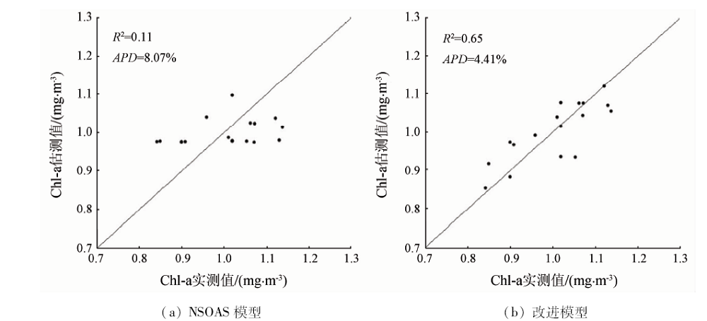
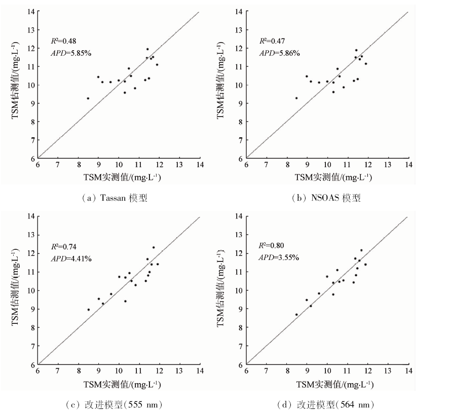
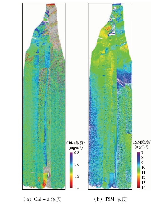
Abstract In view of the low precision of existing water quality element retrieval models applied to the coastal waters of Golden Beach, the authors, based on the statistical retrieval models of water color for case Ⅱ water body in Yellow Sea and East China Sea by Tang Junwu, established the retrieval models of chlorophyll-a and total suspended matter concentration for coastal waters of Golden Beach by using the spectral data obtained from airborne marine hyper-spectrometer. The spatial distribution of chlorophyll-a and total suspended matter concentration in the study area was obtained and the influence of hyper-spectrometer gain on model retrieval accuracy was analyzed. After the models were improved, the determination coefficients and average relative errors between the retrieval results from spectrometer measurements and the sampling measurements were respectively chlorophyll-a 0.65, 4.41%, and total suspended matter 0.80, 3.55%. Retrieval results from the same spectrometer at the same coordinates and approximate time but under different gains were compared. It is proved that retrieval average relative errors and root mean square errors of improved models are all increased and the retrieval accuracy is reduced if gain changes. However, the error is in the allowable range and the model stability is good overall.
|
| Keywords
airborne hyper-spectrometer
Golden Beach
coastal water
chlorophyll-a
total suspended matter
gain
|
|
|
|
Corresponding Authors:
WANG Zhangjun
E-mail: gyygyy1234@163.com;wang@hotmail.com
|
|
Issue Date: 09 October 2020
|
|
|
| [1] |
Kim H C, Son S, Kim Y H, et al. Remote sensing and water quality indicators in the Korean west coast:Spatio-temporal structures of MODIS-derived chlorophyll-a and total suspended solids[J]. Marine Pollution Bulletin, 2017,121(1-2):425-434.
pmid: 28641885
url: https://www.ncbi.nlm.nih.gov/pubmed/28641885
|
| [2] |
姜丽君. 基于遥感反演的近20 a莱州湾表层悬浮泥沙和叶绿素a时空变化研究[D]. 烟台:鲁东大学, 2018.
|
| [2] |
Jiang L J. Temporal and spatial variations of suspended sediment and chlorophyll-a in Laizhou Bay in recent 20 years based on remote sensing inversion[D]. Yantai:Ludong University, 2018.
|
| [3] |
Jong C P, Mayzonee L, Yong S K, et al. High-spatial resolution monitoring of phycocyanin and chlorophyll-a Using Airborne Hyperspectral imagery[J]. Remote Sensing, 2018,10(8):1-31.
doi: 10.3390/rs10010001
url: http://www.mdpi.com/2072-4292/10/1/1
|
| [4] |
Purandara B K, Jamadar B S, Chandramohan T, et al. Water quality assessment of a lentic water body using remote sensing:A case study [C]//Singh V P. Environmental Pollution.Singapore:Springer, 2018: 371-380.
|
| [5] |
张明慧, 苏华, 季博文. MODIS时序影像的福建近岸叶绿素a浓度反演[J]. 环境科学学报, 2018,38(12):4831-4839.
url: http://www.actasc.cn/hjkxxb/ch/reader/view_abstract.aspx?file_no=20180613004&flag=1
|
| [5] |
Zhang M H, Su H, Ji B W. Retrieving nearshore chlorophyll-a concentration using MODIS time-series images in the Fujian Province[J]. Acta Scientiae Circumstantiae, 2018,38(12):4831-4839.
url: http://www.actasc.cn/hjkxxb/ch/reader/view_abstract.aspx?file_no=20180613004&flag=1
|
| [6] |
孙小涵, 胡连波, 冯永亮, 等. 基于HJ-1卫星数据的荣成湾叶绿素a浓度时空变化特征分析[J].海洋湖沼通报, 2018(5):72-79.
|
| [6] |
Sun X H, Hu L B, Feng Y L, et al. Temperal and spatial analysis of chlorophyll a concentration patterns in Rongcheng Bay using HJ-1 satellite data[J].Transactions of Oceanology and Limnology 2018(5):72-79.
|
| [7] |
Cao Y, Ye Y T, Zhao H L, et al. Remote sensing of water quality based on HJ-1A HSI imagery with modified discrete binary particle swarm optimization-partial least squares (MDBPSOPLS) in inland waters:A case in Weishan Lake[J]. Ecological Informatics, 2018,44:21-32.
doi: 10.1016/j.ecoinf.2018.01.004
url: https://linkinghub.elsevier.com/retrieve/pii/S1574954117302261
|
| [8] |
潘邦龙, 申慧彦, 邵慧, 等. 湖泊叶绿素高光谱空谱联合遥感反演[J]. 大气与环境光学学报, 2017,12(6):428-434.
|
| [8] |
Pan B L, Shen H Y, Shao H, et al. Combined inversion of Hyper-spectral remote sensing of space and spectrum for lake chlorophyll[J]. Journal of Atmospheric and Environmental Optics, 2017,12(6):428-434.
|
| [9] |
Mohammad H G, Assefa M M, Lakshmi R. Spaceborne and airborne sensors in water quality assessment[J]. International Journal of Remote Sensing, 2016,37(14):3143-3180.
doi: 10.1080/01431161.2016.1190477
url: http://www.tandfonline.com/doi/full/10.1080/01431161.2016.1190477
|
| [10] |
林剑远, 张长兴. 航空高光谱遥感反演城市河网水质参数[J]. 遥感信息, 2019,34(2):23-29.
|
| [10] |
Lin J Y, Zhang C X. Inversion of water quality parameters of urban river network using airborne hyperspectral remote sensing[J]. Remote Sensing Information, 2019,34(2):23-29.
|
| [11] |
唐军武, 王晓梅, 宋庆君, 等. 黄、东海二类水体水色要素的统计反演模式[J]. 海洋科学进展, 2004,22:1-7.
|
| [11] |
Tang J W, Wang X M, Song Q J, et al. Statistical inversion models for case Ⅱ water color elements in the Yellow Sea and East China Sea[J]. Advances in Marine Science, 2004,22:1-7.
|
| [12] |
Tassan S. Local algorithms using SeaWiFS data for the retrieval of phytoplankton,pigments,suspended sediment,and yellow substance in coastal waters[J]. Applied Optics, 1994,33(12):2369-2378.
doi: 10.1364/AO.33.002369
pmid: 20885588
url: https://www.ncbi.nlm.nih.gov/pubmed/20885588
|
| [13] |
杨俊生, 葛毓柱, 吴琼, 等. 黄岛金沙滩现代波痕沉积特征与水动力关系[J]. 科技导报, 2014,32(1):22-29.
doi: 10.3981/j.issn.1000-7857.2014.002
url: http://www.kjdb.org/CN/abstract/abstract11220.shtml
|
| [13] |
Yang J S, Ge Y Z, Wu Q, et al. Characteristics of ripples both in morphology and sediments in Golden Beach Coastal Zone,Huangdao and the relationship with hydrodynamics[J]. Science and Technology Review, 2014,32(1):22-29.
|
| [14] |
毕顺, 李云梅, 吕恒, 等. 基于OLCI数据的洱海叶绿素a浓度估算[J]. 湖泊科学, 2018,30(3):701-712.
|
| [14] |
Bi S, Li Y M, Lyu H, et al. Estimation of chlorophyll-a concentration in Lake Erhai based on OLCI data[J]. Journal of Lake Sciences, 2018,30(3):701-712.
doi: 10.18307/2018.0312
url: <![CDATA[http://www.jlakes.org/ch/reader/view_abstract.aspx?doi=10.18307/2018.0312]]>
|
| [15] |
黄启会, 贺中华, 梁虹, 等. 基于高光谱数据的百花湖叶绿素a浓度估算[J]. 环境科学与技术, 2019,42(1):134-141.
|
| [15] |
Huang Q H, He Z H, Liang H, et al. Estimation of chlorophyll-a concentration in Baihua Lake water based on hyspectral data[J]. Environmental Science and Technology, 2019,42(1):134-141.
|
|
Viewed |
|
|
|
Full text
|
|
|
|
|
Abstract
|
|
|
|
|
Cited |
|
|
|
|
| |
Shared |
|
|
|
|
| |
Discussed |
|
|
|
|
 2020,
Vol. 32
2020,
Vol. 32
 ), WANG Zhangjun(