|
|
 |
|

|
|
|
Retrieval of total suspended matter concentration in Hangzhou Bay based on simulated HICO from in situ hyperspectral data |
Dingfeng YU1,2,3, Yan ZHOU1,2,3, Wandong MA4( ), Zhigang GAI1,2,3, Enxiao LIU1,2,3 ), Zhigang GAI1,2,3, Enxiao LIU1,2,3 |
1. Institute of Oceanographic Instrumentation,Qilu University of Technology (Shandong Academy of Sciences), Qingdao 266001, China
2. National Engineering and Technological Research Center of Marine Monitoring Equipment, Qingdao 266001, China
3. Key Laboratory of Ocean Optics, Shandong Academy of Sciences, Qingdao 266001, China
4. Satellite Environment Center, Ministey of Ecology and Environment, Beijing 100094, China |
|
|
|
|
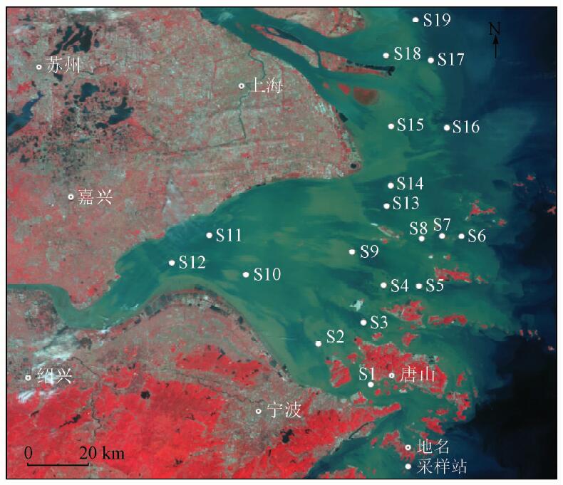
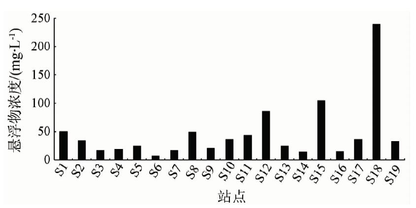
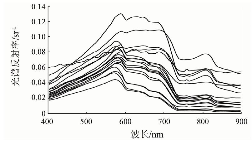
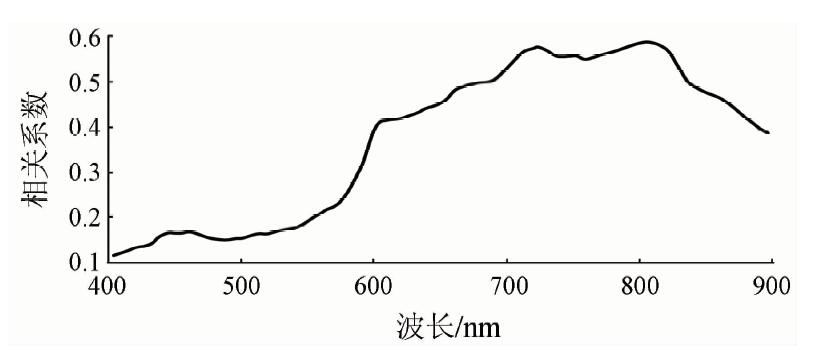
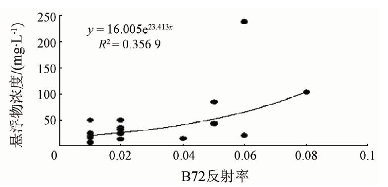
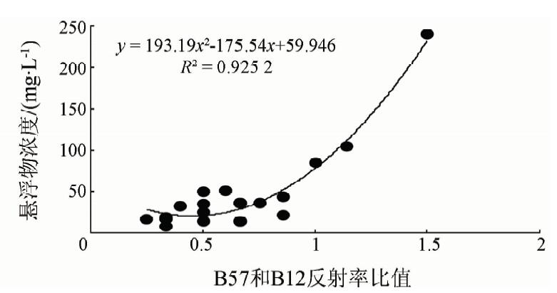
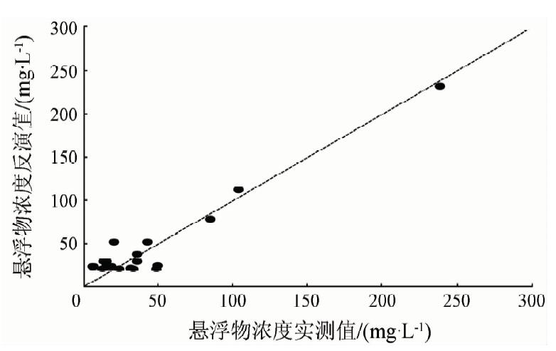
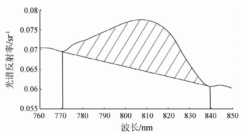
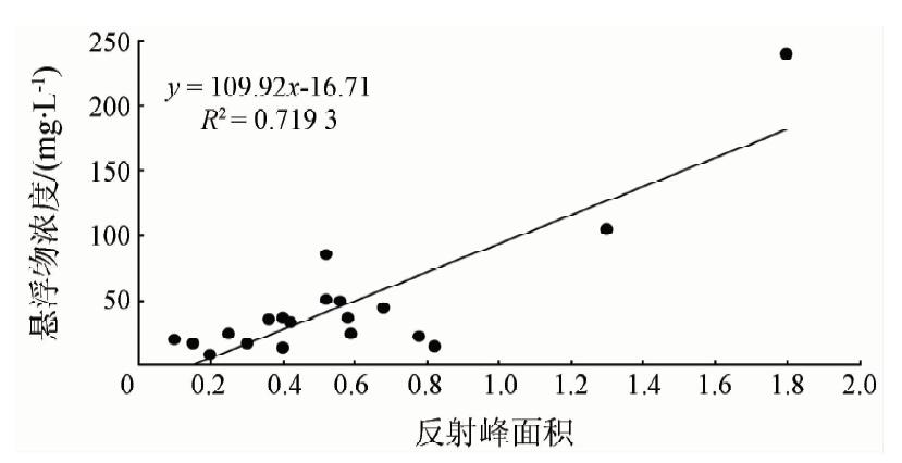
Abstract In this study, field data such as the concentration of total suspended matter (TSM) in Hangzhou Bay and its adjacent areas in Hangzhou’s coastal waters were observed, meanwhile, hyperspectral remote snesing data were measured with SVC GER1500 spectrometer during four cruises carried out on 20th, 22nd, 23rd and 24th July 2010. The coastal water-leaving refectance of HICO was simulated from in situ hyperspectral remote sensing spectra. The normalized peak area of remote sensing reflectance in the near-infrared region was applied to retrieving TSM after the spectra of simulated HICO were analyzed, as well as the application of single band model and band ratio model. The result indicated that the band ratio algorithm of Rrs(724.84)/Rrs(461.36) of HICO could be used to retrieve TSM in Hangzhou Bay. This study is helpful to retrieving TSM in coastal waters using HICO.
|
| Keywords
HICO
total suspended matter
remote sensing
Hangzhou Bay
|
|
|
|
Corresponding Authors:
Wandong MA
E-mail: mawdcn@163.com
|
|
Issue Date: 07 December 2018
|
|
|
| [1] |
Gordon H R, Mccluney W R . Estimation of the depth of sunlight penetration in the sea for remote sensing[J]. Applied Optics, 1975,14(2):413-416.
doi: 10.1364/AO.14.000413
pmid: 20134900
url: https://www.osapublishing.org/abstract.cfm?URI=ao-14-2-413
|
| [2] |
光洁, 韦玉春, 黄家柱 , 等. 分季节的太湖悬浮物遥感估测模型研究[J]. 湖泊科学, 2007,19(3):241-249.
doi: 10.3321/j.issn:1003-5427.2007.03.003
url: http://www.cqvip.com/Main/Detail.aspx?id=24564564
|
| [2] |
Guang J, Wei Y C, Huang J Z , et al. Seasonal suspended sediment models in Lake Taihu using remote sensing data[J]. Journal of Lake Science, 2007,19(3):241-249.
|
| [3] |
Mao Z H, Chen J Y, Pan D L , et al. A regional remote sensing algorithm for total suspended matter in the East China Sea[J]. Remote Sensing of Environment, 2012,124:819-831.
doi: 10.1016/j.rse.2012.06.014
url: https://linkinghub.elsevier.com/retrieve/pii/S0034425712002507
|
| [4] |
He X Q, Bai Y, Pan D L , et al. Using geostationary satellite ocean color data to map the diurnal dynamics of suspended particulate matter in coastal waters[J]. Remote Sensing of Environment, 2013,133:225-239.
doi: 10.1016/j.rse.2013.01.023
url: https://linkinghub.elsevier.com/retrieve/pii/S0034425713000503
|
| [5] |
Mao Z H, Chen J Y, Pan D L , et al. A regional remote sensing algorithm for total suspended matter in the East China Sea[J]. Remote Sensing of Environment, 2012,124:819-831.
doi: 10.1016/j.rse.2012.06.014
url: https://linkinghub.elsevier.com/retrieve/pii/S0034425712002507
|
| [6] |
Binding C E, Bowers D G, Mitchelson-Jacob E G . Estimating suspended sediment concentrations from ocean colour measurements in moderately turbid waters;the impact of variable particle scattering properties[J]. Remote sensing of Environment, 2005,94(3):373-383.
doi: 10.1016/j.rse.2004.11.002
url: http://linkinghub.elsevier.com/retrieve/pii/S003442570400344X
|
| [7] |
Zhang M W, Tang J W, Dong Q , et al. Retrieval of total suspended matter concentration in the Yellow and East China Seas from MODIS imagery[J]. Remote Sensing of Environment, 2010,114(2):392-403.
doi: 10.1016/j.rse.2009.09.016
url: http://linkinghub.elsevier.com/retrieve/pii/S0034425709002880
|
| [8] |
Ahn Y H, Moon J E, Gallegos S . Development of suspended particulate matter algorithms for ocean color remote sensing[J]. Korean Journal of Remote Sensing, 2001,17(4):285-295.
|
| [9] |
宋庆君, 马荣华, 唐军武 , 等. 秋季太湖悬浮物高光谱估算模型[J]. 湖泊科学, 2008,20(2):196-202.
|
| [9] |
Song Q J, Ma R H, Tang J W , et al. Models of estimated total suspend matter concentration base on hyper-spectrum in Lake Taihu,in autumn[J]. Journal of Lake Science, 2008,20(2):196-202.
|
| [10] |
Ma W D, Xing Q G, Chen C Q , et al. Using the normalized peak area of remote sensing reflectance in the near-infrared region to estimate total suspended matter[J]. International Journal of Remote Sensing, 2011,32(22):7479-7486.
doi: 10.1080/01431161.2010.524673
url: https://www.tandfonline.com/doi/full/10.1080/01431161.2010.524673
|
| [11] |
Gitelson A A, Gao B C, Li R R , et al. Estimation of chlorophyll-a concentration in productive turbid waters using a hyperspectral imager for the coastal ocean? The Azov Sea case study[J]. Environmental Research Letters, 2011,6(2):024023.
doi: 10.1088/1748-9326/6/2/024023
url: http://stacks.iop.org/1748-9326/6/i=2/a=024023?key=crossref.533b7023d5901ca90fe4a659f3f4334f
|
| [12] |
Moses W J, Gitelson A A, Berdnikov S , et al. HICO-based NIR-red models for estimating chlorophyll-concentration in productive coastal waters[J]. IEEE Geoscience and Remote Sensing Letters, 2014,11(6):1111-1115.
doi: 10.1109/LGRS.2013.2287458
url: http://ieeexplore.ieee.org/document/6670037/
|
| [13] |
Mishra D R, Schaeffer B A, Keith D . Performance evaluation of normalized difference chlorophyll index in northern Gulf of Mexico estuaries using the hyperspectral imager for the coastal ocean[J]. GIScience and Remote Sensing, 2014,51(2):175-198.
doi: 10.1080/15481603.2014.895581
url: http://www.tandfonline.com/doi/abs/10.1080/15481603.2014.895581
|
| [14] |
Braga F, Giardino C, Bassani C , et al. Assessing water quality in the northern Adriatic Sea from HICO TM data [J]. Remote Sensing Letters, 2013,4(10):1028-1037.
doi: 10.1080/2150704X.2013.830203
url: http://www.tandfonline.com/doi/abs/10.1080/2150704X.2013.830203
|
| [15] |
Keith D J, Schaeffer B A, Lunetta R S , et al. Remote sensing of selected water-quality indicators with the hyperspectral imager for the coastal ocean (HICO) sensor[J]. International Journal of Remote Sensing, 2014,35(9):2927-2962.
doi: 10.1080/01431161.2014.894663
url: https://www.tandfonline.com/doi/full/10.1080/01431161.2014.894663
|
| [16] |
Garcia R A , Fearns P R C S,Mckinna L I W.Detecting trend and seasonal changes in bathymetry derived from HICO imagery:A case study of Shark Bay,Western Australia[J]. Remote Sensing of Environment, 2014,147:186-205.
doi: 10.1016/j.rse.2014.03.010
url: https://linkinghub.elsevier.com/retrieve/pii/S0034425714000819
|
| [17] |
Sathyendranath S . Remote Sensing of Ocean Colour in Coastal,and Other Optically-complex,Waters[R].Dartmouth:the International Ocean- Colour Coordinating Group, 2000.
|
| [18] |
Smith R C, Baker K S . Optical properties of the clearest natural waters(200-800 nm)[J]. Applied Optics, 1981,20(2):177-184.
doi: 10.1364/AO.20.000177
pmid: 20309088
url: https://www.osapublishing.org/abstract.cfm?URI=ao-20-2-177
|
| [19] |
Pope R M, Fry E S . Absorption spectrum (380-700 nm) of pure water.II.Integrating cavity measurements[J]. Applied Optics, 1997,36(33):8710-8723.
doi: 10.1364/AO.36.008710
url: https://www.osapublishing.org/abstract.cfm?URI=ao-36-33-8710
|
| [20] |
Koponen S, Pulliainen J, Kallio K , et al. Lake water quality classification with airborne hyperspectral spectrometer and simulated MERIS data[J]. Remote Sensing of Environment, 2002,79(1):51-59.
doi: 10.1016/S0034-4257(01)00238-3
url: http://linkinghub.elsevier.com/retrieve/pii/S0034425701002383
|
|
Viewed |
|
|
|
Full text
|
|
|
|
|
Abstract
|
|
|
|
|
Cited |
|
|
|
|
| |
Shared |
|
|
|
|
| |
Discussed |
|
|
|
|
 2018,
Vol. 30
2018,
Vol. 30