|
|
 |
|

|
|
|
A study of the landscape fragmentations of land cover structure based on Landsat8 remote sensing image: A case study of Mata watershed in Yan’an, Shaanxi Province |
LI Guoqing1,2( ), HUANG Jinghua1,2, LIU Guan3, LI Jie3, ZHAI Bochao3, DU Sheng1,2 ), HUANG Jinghua1,2, LIU Guan3, LI Jie3, ZHAI Bochao3, DU Sheng1,2 |
1. State Key Laboratory of Soil Erosion and Dryland Farming on the Loess Plateau, Northwest A&F University, Yangling 712100,China
2. Institute of Soil and Water Conservation, Chinese Academy of Sciences and Ministry of Water Resources,Yangling 712100, China
3. College of Forestry, Northwest A&F University, Yangling 712100, China |
|
|
|
|
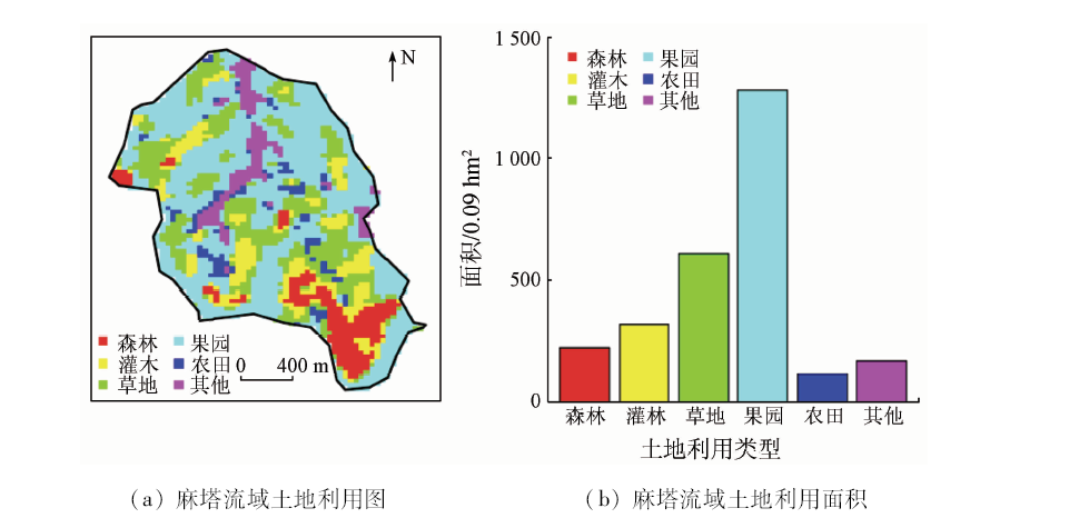
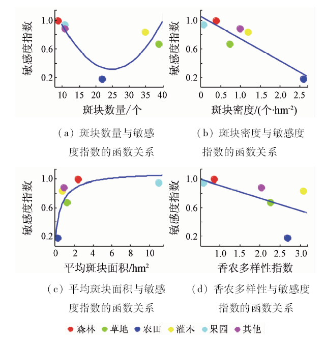
Abstract The process of landscape fragmentation is accompanied by the decline of landscape function. Therefore, the study of landscape fragmentation is of great significance for timely monitoring of ecological security and adjustment of land cover structure. This research was designed to map the current status of land cover structure of Mata watershed using supervised classification algorithms in south of Yan’an City based on Landsat 8 satellite data and to describe its landscape fragmentation using six fragmentation indices at three organization levels: patch, class, and landscape. The results are as follows: ① The status of land cover in this area can be characterized accurately based on Landsat8 satellite image and the accuracy of supervised classification is 74% together with the kappa value of 0.68; ② Mata watershed can be classified into 6 land cover classes, i.e., forest land, shrub land, grass land, orchards land, farm land, and others land (road and village). The orchard land occupies the largest area in all land cover types; ③ The extent of landscape fragmentation for shrub, grass and farm lands is relatively more serious than that of forest, orchard and others lands, indicating that landscape functions of shrub, grass and farm lands have been weakened in capability of ecological protection and agricultural production; ④ Transforming small patches of shrub, grass and farm lands into adjacent land type with large patches should improve the integration level of landscape in the Mata watershed, which is conducive to the improvement of landscape function in Mata watershed.
|
| Keywords
landscape fragmentation
land cover
remote sensing image
random forest
Mata watershed
|
|
|
|
Issue Date: 09 October 2020
|
|
|
| [1] |
马克明, 傅伯杰. 北京东灵山地区景观格局及破碎化评价[J]. 植物生态学报, 2000,24(3):320-326.
url: http://www.plant-ecology.com/CN/abstract/abstract10161.shtml
|
| [1] |
Ma K M, Fu B J. Landscape pattern and fragmentation in Donglingshan Mountain region[J]. Acta Phytoecologica Sinica, 2000,24(3):320-326.
|
| [2] |
洪鸿加, 彭晓春, 陈志良, 等. 长沙市景观破碎化时空分异特征研究[J]. 国土资源遥感, 2011,23(1):133-137.doi: 10.6046/gtzyyg.2011.01.27.
doi: 10.6046/gtzyyg.2011.01.27
url: http://www.gtzyyg.com/CN/abstract/abstract610.shtml
|
| [2] |
Hong H J, Peng X C, Chen Z L, et al. The investigation of spatiotemporal patterns of landscape fragmentation during rapid urbanization in Changsha City[J]. Remote Sensing for Land and Resources, 2011,23(1):133-137.doi: 10.6046/gtzyyg.2011.01.27.
|
| [3] |
Nagendra H, Munroe D K, Southworth J. From pattern to process:Landscape fragmentation and the analysis of land use/land cover change[J]. Agriculture Ecosystems & Environment, 2004,101(2-3):111-115.
|
| [4] |
邬建国. 景观生态学——格局、过程、尺度与等级[M]. 北京: 高等教育出版社, 2000.
|
| [4] |
Wu J G. Landscape ecology:Pattern,process,scale and hierarchy[M]. Beijing: Higher Education Press, 2000.
|
| [5] |
王宪礼, 肖笃宁, 布仁仓, 等. 辽河三角洲湿地的景观格局分析[J]. 生态学报, 1997,17(3):317-323.
url: http://www.ecologica.cn/stxb/ch/reader/view_abstract.aspx?file_no=970316&flag=1
|
| [5] |
Wang X L, Xiao D N, Bu R C, et al. Analysis on landscape patterns of Liaohe delta wetland[J]. Acta Ecologica Sinica, 1997,17(3):317-323.
|
| [6] |
Ferreira I J M, Bragion G D, Ferreira J H D, et al. Landscape pattern changes over 25 years across a hotspot zone in southern Brazil[J]. Southern Forests, 2019,81(2):175-184.
doi: 10.2989/20702620.2018.1542563
url: https://www.tandfonline.com/doi/full/10.2989/20702620.2018.1542563
|
| [7] |
Wang B, Li J, Jin X F, et al. Mapping tea plantations from multi-seasonal landsat-8 OLI imageries using a random forest classifier[J]. Journal of the Indian Society of Remote Sensing, 2019,47(8):1315-1329.
doi: 10.1007/s12524-019-01014-5
url: https://doi.org/10.1007/s12524-019-01014-5
|
| [8] |
魏彦昌, 吴炳方, 张喜旺, 等. 基于高分辨率影像的景观格局定量分析[J]. 国土资源遥感, 2009,21(2):76-81,86.doi: 10.6046/gtzyyg.2009.02.16.
doi: 10.6046/gtzyyg.2009.02.16
url: http://www.gtzyyg.com/CN/abstract/abstract42.shtml
|
| [8] |
Wei Y C, Wu B F, Zhang X W, et al. A quantitative analysis of the landscape pattern based on high resolution satellite image[J]. Remote Sensing for Land and Resources, 2009,21(2):76-81,86.doi: 10.6046/gtzyyg.2009.02.16.
|
| [9] |
徐涵秋, 唐菲. 新一代landsat系列卫星:Landsat8遥感影像新增特征及其生态环境意义[J]. 生态学报, 2013,33(11):3249-3257.
doi: 10.5846/stxb201305030912
url: http://www.ecologica.cn/stxb/ch/reader/view_abstract.aspx?file_no=stxb201305030912&flag=1
|
| [9] |
Xu H Q, Tang F. Analysis of new characteristics of the first Landsat8 image and their ecoenvironmental significance[J]. Acta Ecologica Sinica, 2013,33(11):3249-3257.
doi: 10.5846/stxb
url: http://www.ecologica.cn/
|
| [10] |
赵英时. 遥感应用分析原理与方法[M]. 北京: 科学出版社, 2003.
|
| [10] |
Zhao Y S. Principles and methods of remote sensing for applied anaysis[M]. Beijing: Science Press, 2003.
|
| [11] |
王敏, 高新华, 陈思宇, 等. 基于Landsat 8遥感影像的土地利用分类研究——以四川省红原县安曲示范区为例[J]. 草业科学, 2015,32(5), 694-701.
doi: 10.11829\j.issn.1001-0629.2014-0263
url: http://cykx.lzu.edu.cn/CN/abstract/abstract11113.shtml
|
| [11] |
Wang M, Gao X H, Chen S Y, et al. The land use classification based on Landsat8 remote sensing image:A case study of Anqu demonstration community in Hongyuan County of Sichuan Province[J]. Pratacultural Science, 2015,32(5):694-701.
doi: 10.11829\j.issn.1001-0629.2014-0263
url: http://cykx.lzu.edu.cn/CN/abstract/abstract11113.shtml
|
| [12] |
许伟, 奚砚涛. 基于Landsat8遥感影像的合肥市土地利用分类[J]. 湖北农业科学, 2015,54:3625-3629,3637.
|
| [12] |
Xu W, Xi Y T. Research on land use classification in Hefei based on Landsat8 images[J]. Hubei Agricultural Science, 2015,54(15):3625-3629,3637.
|
| [13] |
李国庆, 张晓芹, 杜盛. 基于随机森林模型的黄土高原林草界线模拟研究[J]. 中国科技论文, 2017,12(15):1780-1784.
|
| [13] |
Li G Q, Zhang X Q, Du S. Simulating the boundary of forest and grass on the Loess Plateau based on random forest model[J]. China Sciencepaper, 2017,12(15):1780-1784.
|
| [14] |
杜盛, 刘国彬. 黄土高原植被恢复的生态功能[M]. 北京: 科学出版社, 2015.
|
| [14] |
Du S, Liu G B. Ecological functions of vegetation restoration on the loess plateau[M]. Beijing: Science Press, 2015.
|
| [15] |
买凯乐, 张文辉. 黄土丘陵沟壑区遥感影像信息面向对象分类方法提取[J]. 农业机械学报, 2011,42(4):153-158.
|
| [15] |
Mai K L, Zhang W H. Object oriented classification approach for remote sensing imagery information extraction in loess hilly gully region[J]. Transactions of the Chinese Society of Agricultural Machinery, 2011,42(4):153-158.
|
| [16] |
谭莹, 徐军亮, 毛华英. 基于landsat8影像的植被信息提取最佳波段组合研究——以浙江省龙泉市为例[J]. 华东森林经理, 2019,33:71-76.
|
| [16] |
Tan Y, Xu J L, Mao H Y. Research of optimum bands combination for vegetation information extraction based on Landsat8 image:A case study of Longquan City,Zhejiang Province[J]. East China Forest Management, 2019,33(2):71-76.
|
| [17] |
张金龙, 常胜. Landsat8影像在土地利用分类中的最大波段组合研究——以湖北恩施市为例[J]. 湖北民族学院学报(自然科学版), 2015,33(4):467-470.
|
| [17] |
Zhang J L, Chang S. Optimum bands combination of Landsat8 image in land use classification:A case study of Enshi City,Hubei Province[J]. Journal of Hubei University for Nationalities(Natural Science Edition), 2015,33(4):467-470.
|
| [18] |
侯晓瑞, 薛志婧, 程曼, 等. 黄土丘陵区纸坊沟小流域土壤有机碳储量研究[J]. 水土保持通报, 2012,32(2):21-25.
|
| [18] |
Hou X R, Xue Z J, Cheng M, et al. Soil organic carbon storage in Zhifanggou watershed of loess hilly region[J]. Bulletin of Soil and Water Conservation, 2012,32(2):21-25.
|
| [19] |
Breiman L. Random forests[J]. Machine Learning, 2001,45:5-32.
doi: 10.1023/A:1010933404324
url: http://www.springerlink.com/content/u0p06167n6173512/
|
| [20] |
魏娜思. 基于高分影像的林地覆盖遥感动态监测[J]. 信息通信, 2019,3:19-22.
|
| [20] |
Wei N S. Dynamic sensing remote monitoring of forest cover based on high resolution images[J]. Information and Communications, 2019,3:19-22.
|
| [21] |
Thomas N, Hanna M, Florian D, et al. Satellite:Manipulating satellite data with satellite[EB/OL]. 2016, URL,https://cran.r-project.org/web/packages/satellite/index.html.
url: https://cran.r-project.org/web/packages/satellite/index.html
|
| [22] |
Li G Q, Du S, Wen Z M. Mapping the climatic suitable habitat of oriental arborvitae (Platycladus orientalis) for introduction and cultivation at a global scale[J]. Scientific Reports, 2016,6:30009.doi: 10.1038/srep30009.
doi: 10.1038/srep30009
pmid: 27443221
url: https://www.ncbi.nlm.nih.gov/pubmed/27443221
|
| [23] |
Stockwell D, Peters D. The GARP modelling system:Problems and solutions to automated spatial prediction[J]. International Journal of Geographical Information Science, 1999,13(2):143-158.
doi: 10.1080/136588199241391
url: http://www.tandfonline.com/doi/abs/10.1080/136588199241391
|
| [24] |
Hijmans R J. Raster:Geographic data analysis and modeling.R package version 2.5-8 2016.https://CRAN.R-project.org/package=raster.
url: https://CRAN.R-project.org/package=raster
|
| [25] |
Mcgannon K R, Marks B J. FRAGSTATS:Spatial pattern analysis program for quantifying landscape structure[R].U.S.Department of Agriculture,Forest Service, Pacific Northwest Research Station, 1995.
|
| [26] |
王斌, 刘华, 张硕新, 等. 秦岭火地唐林区景观格局破碎化分析[J]. 中国农学通报, 2005,21(10):111-113,143.
url: http://www.casb.org.cn/CN/abstract/abstract16077.shtml
|
| [26] |
Wang B, Liu H, Zhang S X, et al. Study on landscape fragmentation of Qinling huoditang forest region[J]. Chinese Agricultural Science Bulletin, 2005,21(10):111-113,143.
url: http://www.casb.org.cn/CN/abstract/abstract16077.shtml
|
| [27] |
Vanderwal J, Falconi L, Januchowski S, et al.SDMTools:Species distribution modelling tools:tools for processing data associated with species distribution modelling exercises.R package version 1.1-221[EB/OL].2014. https://CRAN.R-project.org/package=SDMTools.
url: https://CRAN.R-project.org/package=SDMTools
|
| [28] |
Araujo M B, New M. Ensemble forecasting of species distributions[J]. Trends in Ecology & Evolution, 2007,22(1):42-47.
doi: 10.1016/j.tree.2006.09.010
pmid: 17011070
url: https://www.ncbi.nlm.nih.gov/pubmed/17011070
|
| [29] |
Desmet P G. Using landscape fragmentation thresholds to determine ecological process targets in systematic conservation plans[J]. Biological Conservation, 2018,221:257-260.
doi: 10.1016/j.biocon.2018.03.025
url: https://linkinghub.elsevier.com/retrieve/pii/S0006320717308613
|
| [30] |
Minor E S, Tessel S M, Engelhardt K A M, et al. The role of landscape connectivity in assembling exotic plant communities:A network analysis[J]. Ecology, 2009,90(7):1802-1809.
pmid: 19694129
url: https://www.ncbi.nlm.nih.gov/pubmed/19694129
|
| [31] |
Brassil C E. Mean time to extinction of a metapopulation with an Allee effect[J]. Ecological Modelling, 2001,143(1-2):9-16.
doi: 10.1016/S0304-3800(01)00351-9
url: https://linkinghub.elsevier.com/retrieve/pii/S0304380001003519
|
|
Viewed |
|
|
|
Full text
|
|
|
|
|
Abstract
|
|
|
|
|
Cited |
|
|
|
|
| |
Shared |
|
|
|
|
| |
Discussed |
|
|
|
|
 2020,
Vol. 32
2020,
Vol. 32