|
|
 |
|

|
|
|
A study of information extraction of rape and winter wheat planting in Jianghan Plain based on MODIS EVI |
YANG Huan1( ), DENG Fan1, ZHANG Jiahua2(), WANG xueting1, MA Qingxiao1, XU Nuo1 ), DENG Fan1, ZHANG Jiahua2(), WANG xueting1, MA Qingxiao1, XU Nuo1 |
1. School of Geosciences, Yangtze University, Wuhan 430100, China
2. Aerospace Information Research Institute, Chinese Academy of Sciences, Beijing 100094, China |
|
|
|
|
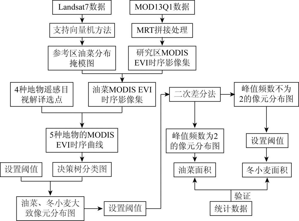
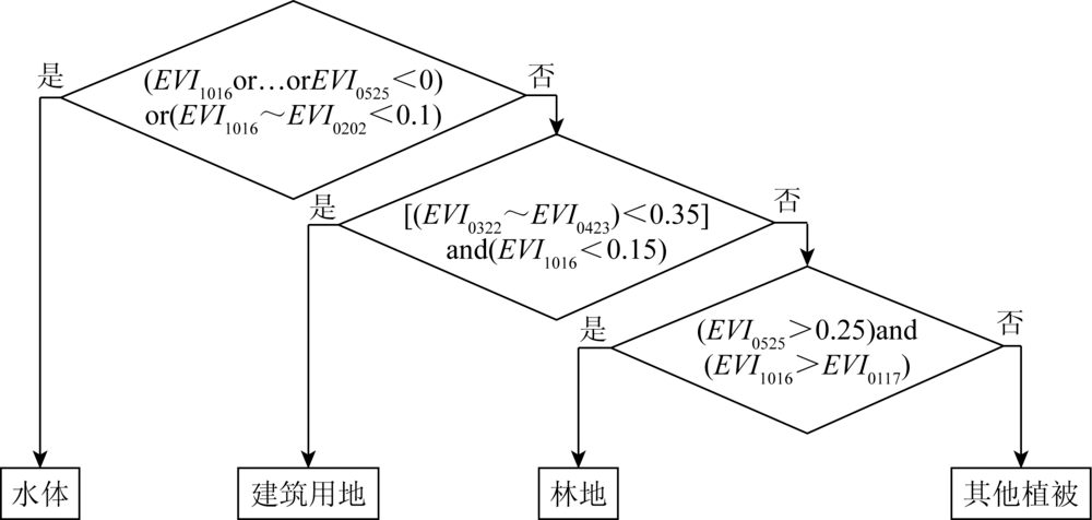
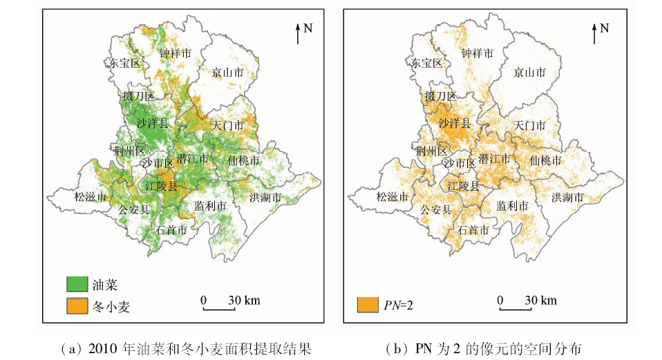
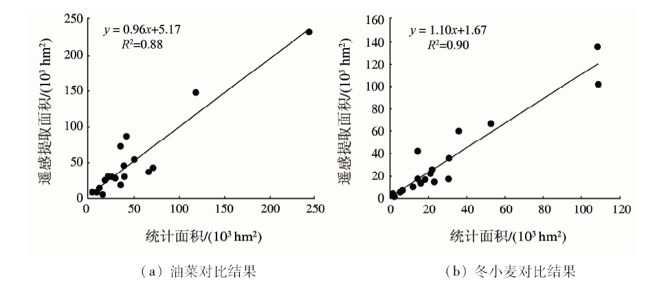
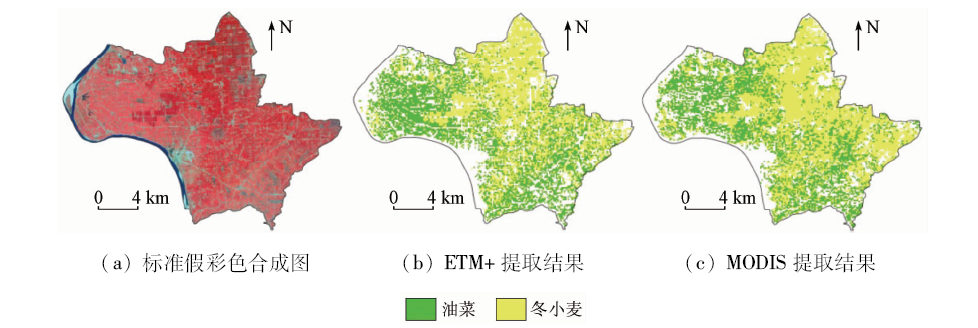
Abstract Two crops with similar growth periods are likely to be confused during remote sensing recognition,which brings difficulties to crop identification and area extraction. For the purpose of solving this problem,Jianghan Plain was used as the study area and,according to the MODIS EVI timing curve of different features in combination with the spectral characteristics of the objects themselves and the phenological information of crops,the combination of decision tree and quadratic difference method was used to extract the planting area of rape and winter wheat in Jianghan Plain in 2010. The results showed that, compared with the statistical data,the overall accuracy of remote sensing extraction of rape and winter wheat planting area in the study area was 93.7% and 87.1%,respectively, and that, at the city (county, district) level,the correlation coefficient R 2 between calculated data and statistical data is 0.88,and the winter wheat is 0.90. This study can accurately identify rape and winter wheat with similar growth periods so as to obtain better results of planting area extraction,which has certain universality and can provide technical support for monitoring and estimating yield of rape and winter wheat in Jianghan Plain.
|
| Keywords
rape
winter wheat
area extraction
MODIS EVI
Jianghan Plain
|
|
|
|
Corresponding Authors:
ZHANG Jiahua
E-mail: yanghuan1105@163.com;zhangjh@radi.ac.cn
|
|
Issue Date: 09 October 2020
|
|
|
| [1] |
胡琼. 基于时序MODIS影像的农作物遥感识别方法研究[D]. 北京:中国农业科学院, 2018: 17-33.
|
| [1] |
Hu Q. Research on crop remote sensing recognition method based on time series MODIS image[D]. Beijing:Chinese Academy of Agricultural Sciences, 2018: 17-33.
|
| [2] |
Wu B, Gommes R, Zhang M, et al. Global crop monitoring:A satellite-based hierarchical approach[J]. Remote Sensing, 2015,7(4):3907-3933.
doi: 10.3390/rs70403907
url: http://www.mdpi.com/2072-4292/7/4/3907
|
| [3] |
张煦. 基于MODIS-NDVI时间序列数据的油菜识别与复种指数提取[D]. 武汉:华中农业大学, 2015: 6-11.
|
| [3] |
Zhang X. Identification of rapeseed and multiple cropping index based on MODIS-NDVI time series data[D]. Wuhan:Huazhong Agricultural University, 2015: 6-11.
|
| [4] |
梁益同, 万君. 基于HJ-1A/B-CCD影像的湖北省冬小麦和油菜分布信息的提取方法[J]. 中国农业气象, 2012,33(4):573-578.
doi: 10.3969/j.issn.1000-6362.2012.04.015
url: http://zgnyqx.ieda.org.cn//CN/abstract/abstract2988.shtml
|
| [4] |
Liang Y T, Wan J. Extraction method of winter wheat and rape distribution information in Hubei Province based on HJ-1A/B-CCD image[J]. Chinese Journal of Agrometeorology, 2012,33(4):573-578.
doi: 10.3969/j.issn.1000-6362.2012.04.015
url: http://zgnyqx.ieda.org.cn//CN/abstract/abstract2988.shtml
|
| [5] |
潘耀忠, 李乐, 张锦水, 等. 基于典型物候特征的MODIS-EVI时间序列数据农作物种植面积提取方法——小区域冬小麦实验研究[J]. 遥感学报, 2011,15(3):578-594.
doi: 10.11834/jrs.20110066
url: http://www.jors.cn/jrs/ch/reader/view_abstract.aspx?file_no=r10066&flag=1
|
| [5] |
Pan Y Z, Li L, Zhang J S, et al. Extraction method of crop planting area based on typical phenological characteristics of MODIS-EVI time series data:Experimental study on winter wheat in small area[J]. Journal of Remote Sensing, 2011,15(3):578-594.
doi: 10.11834/jrs.20110066
url: http://www.jors.cn/jrs/ch/reader/view_abstract.aspx?file_no=r10066&flag=1
|
| [6] |
李卫国, 李花, 王纪华, 等. 基于Landsat/TM遥感的冬小麦长势分级监测研究[J]. 麦类作物学报, 2010,30(1):92-95.
doi: 10.7606/j.issn.1009-1041.2010.01.019
url: http://www.tcrop.net/mlzwxb/ch/reader/view_abstract.aspx?file_no=20100119&flag=1
|
| [6] |
Li W G, Li H, Wang J H, et al. Study on the grading monitoring of winter wheat growth based on Landsat/TM remote sensing[J]. Journal of Triticeae Crops, 2010,30(1):92-95.
doi: 10.7606/j.issn.1009-1041.2010.01.019
url: http://www.tcrop.net/mlzwxb/ch/reader/view_abstract.aspx?file_no=20100119&flag=1
|
| [7] |
Jakubauskas M E, Legates D R, Kastens J H. Crop identification using harmonic analysis of time-series AVHRR NDVI data[J]. Computers & Electronics in Agriculture, 2002,37(1):127-139.
|
| [8] |
Hill M J, Donald G E. Estimating spatio-temporal patterns of agricultural productivity in fragmented landscapes using AVHRR NDVI time series[J]. Remote Sensing of Environment, 2003,84(3):367-384.
doi: 10.1016/S0034-4257(02)00128-1
url: https://linkinghub.elsevier.com/retrieve/pii/S0034425702001281
|
| [9] |
郭昱杉, 刘庆生, 刘高焕, 等. 基于MODIS时序NDVI主要农作物种植信息提取研究[J]. 自然资源学报, 2017,32(10):1808-1818.
|
| [9] |
Guo Y S, Liu Q S, Liu G H, et al. Research on planting information extraction of main crops based on MODIS timing NDVI[J]. Journal of Natural Resources, 2017,32(10):1808-1818.
|
| [10] |
尤慧, 苏荣瑞, 肖玮钰, 等. 基于MODIS EVI时序数据的江汉平原油菜种植分布信息提取[J]. 国土资源遥感, 2018,30(1):173-179.doi: 10.6046/gtzyyg.2018.01.24.
|
| [10] |
You H, Su R R, Xiao W Y, et al. Extraction of Jianghan Plain oil vegetable planting distribution information based on MODIS EVI time series data[J]. Remote Sensing for Land and Resources, 2018,30(1):173-179.doi: 10.6046/gtzyyg.2018.01.24.
|
| [11] |
Lhermitte S, Verbesselt J, Verstraeten W W, et al. A comparison of time series similarity measures for classification and change detection of ecosystem dynamics[J]. Remote Sensing of Environment, 2011,115(12):31-52.
|
| [12] |
康峻, 侯学会, 牛铮, 等. 基于拟合物候参数的植被遥感决策树分类[J]. 农业工程学报, 2014,30(9):148-156.
url: http://www.tcsae.org/nygcxb/ch/reader/view_abstract.aspx?file_no=20140919&flag=1
|
| [12] |
Kang J, Hou X H, Niu Z, et al. Vegetation remote sensing decision tree classification based on fitting phenological parameters[J]. Transactions of the Chinese Society of Agricultural Engineering, 2014,30(9):148-156.
url: http://www.tcsae.org/nygcxb/ch/reader/view_abstract.aspx?file_no=20140919&flag=1
|
| [13] |
张煦, 马驿, 郑雯, 等. 基于时序MODIS-NDVI的油菜种植面积变化趋势分析——以江汉平原为例[J]. 长江流域资源与环境, 2016,25(3):412-419.
doi: 10.11870/cjlyzyyhj201603007
url: http://yangtzebasin.whlib.ac.cn//CN/abstract/abstract11178.shtml
|
| [13] |
Zhang X, Ma Y, Zheng W, et al. Analysis of the change trend of rapeseed planting area based on time series MODIS-NDVI:Taking Jianghan Plain as an example[J]. Journal of Yangtze River Resources and Environment, 2016,25(3):412-419.
|
| [14] |
申健, 常庆瑞, 李粉玲, 等. 基于时序NDVI的关中地区冬小麦种植信息遥感提取[J]. 农业机械学报, 2017,48(3):215-220,260.
|
| [14] |
Shen J, Chang Q R, Li F L, et al. Remote sensing extraction of winter wheat planting information in Guanzhong area based on time series NDVI[J]. Transactions of the Chinese Society of Agricultural Machinery, 2017,48(3):215-220,260.
|
| [15] |
张莎, 张佳华, 白雲, 等. 基于MODIS-EVI及物候差异免阈值提取黄淮海平原冬小麦面积[J]. 农业工程学报, 2018,34(11):150-158.
|
| [15] |
Zhang S, Zhang J H, Bai Y, et al. Extraction of winter wheat area in Huanghuaihai Plain based on MODIS-EVI and phenological difference threshold extraction[J]. Transactions of the Chinese Society of Agricultural Engineering, 2018,34(11):150-158.
|
| [16] |
王琳, 景元书, 杨沈斌. 基于多时相遥感数据提取水稻种植面积的研究[J]. 中国农业资源与区划, 2013,34(2):21-26.
|
| [16] |
Wang L, Jing Y S, Yang S B. Study on extraction of rice planting area based on multi-temporal remote sensing data[J]. China’s Agricultural Resources and Zoning, 2013,34(2):21-26.
|
| [17] |
湖北省统计局. 湖北统计年鉴[M]. 北京: 中国统计出版社, 2010.
|
| [17] |
Hubei Provincial Statistics Bureau. Hubei statistical yearbook[M]. Beijing: China Statistics Press, 2010.
|
| [18] |
王利军, 郭燕, 贺佳, 等. 基于决策树和SVM的Sentinel-2A影像作物提取方法[J]. 农业机械学报, 2018,49(9):146-153.
|
| [18] |
Wang L J, Guo Y, He J, et al. Sentinel-2A image crop extraction method based on decision tree and SVM[J]. Transactions of the Chinese Society of Agricultural Machinery, 2018,49(9):146-153.
|
| [19] |
王雪婷, 张莎, 邓帆, 等. 基于作物空间物候差异提取黄淮海夏玉米种植面积[J]. 中国农业气象, 2019,40(10):647-659.
|
| [19] |
Wang X T, Zhang S, Deng F, et al. Extraction of summer maize planting area in Huang-Huai-Hai based on differences in crop space phenology[J]. China Agricultural Meteorology, 2019,40(10):647-659.
|
| [20] |
王凯, 张佳华. 基于MODIS数据的湖北省油菜种植分布信息提取[J]. 国土资源遥感, 2015,27(3):65-70.doi: 10.6046/gtzyyg.2015.03.12.
doi: 10.6046/gtzyyg.2015.03.12
url: http://www.gtzyyg.com/CN/abstract/abstract1891.shtml
|
| [20] |
Wang K, Zhang J H. Extraction of rapeseed planting distribution information based on MODIS data in Hubei Province[J]. Remote Sensing for Land and Resources, 2015,27(3):65-70.doi: 10.6046/gtzyyg.2015.03.12.
|
| [21] |
贺原惠子, 王长林, 贾慧聪, 等. 基于随机森林算法的冬小麦提取研究[J]. 遥感技术与应用, 2018,33(6):1132-1140.
|
| [21] |
He Y H Z, Wang C L, Jia H C, et al. Research on winter wheat extraction based on random forest algorithm[J]. Remote Sensing Technology and Application, 2018,33(6):1132-1140.
|
| [22] |
湖北省统计局. 湖北统计年鉴[M]. 北京: 中国统计出版社, 2011.
|
| [22] |
Hubei Provincial Statistics Bureau. Hubei statistical yearbook[M]. Beijing: China Statistics Press, 2011.
|
|
Viewed |
|
|
|
Full text
|
|
|
|
|
Abstract
|
|
|
|
|
Cited |
|
|
|
|
| |
Shared |
|
|
|
|
| |
Discussed |
|
|
|
|
 2020,
Vol. 32
2020,
Vol. 32