|
|
|
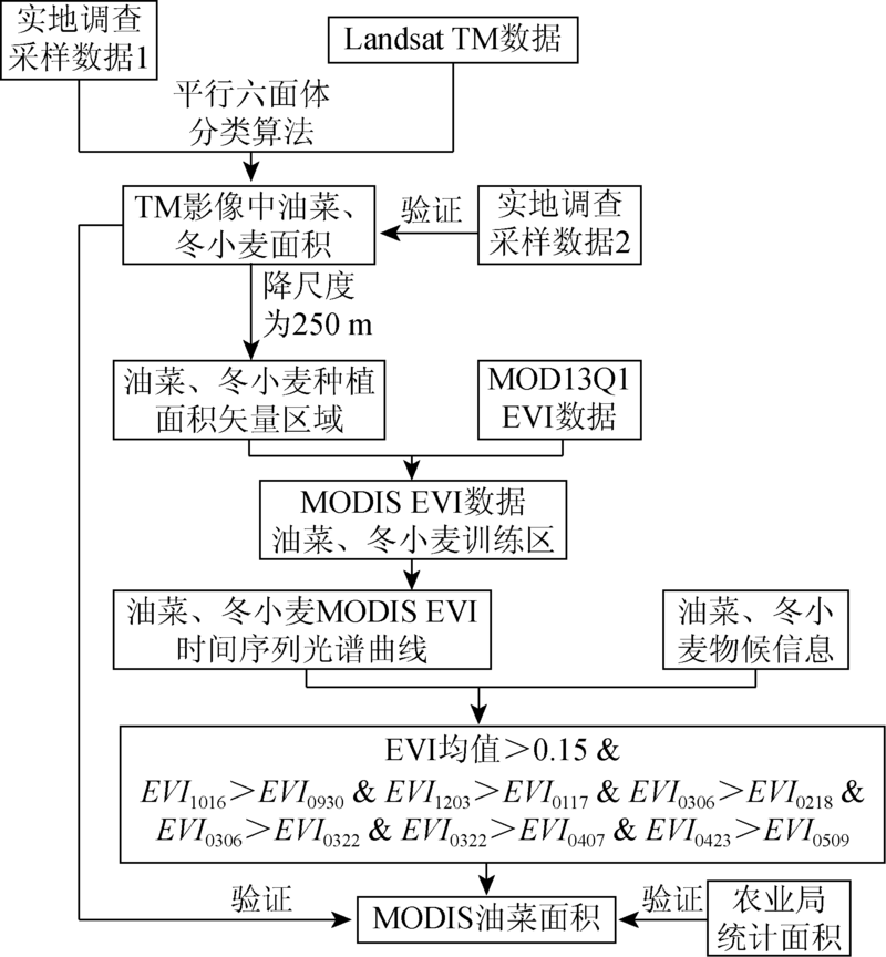
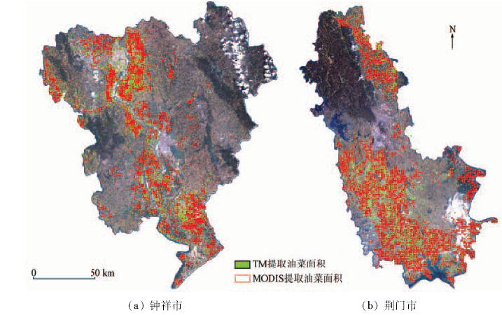
Abstract Rape is the major oil crop in China, and timely and accurately obtaining the information about rape planting spatial pattern has great significance for growth monitoring, yield estimation and disaster assessment. In this paper, the distribution of rape growing in the Jianghan Plain from 2014 to 2015 was extracted utilizing the MODIS EVI time series data with 250 m spatial resolution. The field survey data were used to extract crop training samples for MODIS EVI data indirectly by using TM data as the transition data between the field survey data and MODIS EVI image. According to the spectra and phenological calendar of winter wheat and rape in Jianghan Plain, the authors established the extraction model for the area of rape growing by multiple threshold comparative method. With the Agricultural Bureau Statistics data as the verification, the overall accuracy of the extraction results of MODIS data were up to 95.22% and 91.29% respectively in 2014 and 2015. In addition, the extraction result was quite consistent with TM-based result with a precision of 88.61%, in 2014. The results show that, based on the time series MODIS-EVI data sets, combined with the EVI spectral characteristics and phenological information of crop and using the study method presented in this paper, the rape planting distribution information could be extracted effectively in Jianghan Plain.
|
| Keywords
MODIS EVI
time series
rape planting area
Jianghan Plain
|
|
|
|
Issue Date: 08 February 2018
|
|
|
| [1] |
张煦,马驿,郑雯,等.基于时序MODIS-NDVI的油菜种植面积变化趋势分析——以江汉平原为例[J].长江流域资源与环境,2016,25(3):412-149.
|
| [1] |
Zhang X,Ma Y,Zheng W,et al.Variation trend of rape cultivation area based on MODIS-NDVI time series data:A case in Jianghan Plain[J].Resources and Environment in the Yangtze Basin,2016,25(3):412-419.
|
| [2] |
张煦. 基于MODIS-NDVI时间序列数据的油菜识别与复种指数提取[D].武汉:华中农业大学,2015.
|
| [2] |
Zhang X.Study on Rape Discrimination and Multiple Cropping Index Extraction Based on MODIS-NDVI Time Series Data[D].Wuhan:Huazhong Agricultural University,2015.
|
| [3] |
王凯,张佳华.基于MODIS数据的湖北省油菜种植分布信息提取[J].国土资源遥感,2015,27(3):65-70.doi:10.6046/gtzyyg.2015.03.12.
|
| [3] |
Wang K,Zhang J H.Extraction of rape seed cropping distribution information in Hubei Province based on MODIS images[J].Remote Sensing for Land and Resources,2015,27(3):65-70.doi:10.6046/gtzyyg.2015.03.12.
|
| [4] |
梁益同,万君.基于HJ-1A/B-CCD影像的湖北省冬小麦和油菜分布信息的提取方法[J].中国农业气象,2012,33(4):573-578.
|
| [4] |
Liang Y T,Wan J.Application of HJ-1A/B-CCD images in extracting the distribution of winter wheat and rape in Hubei Province[J].Chinese Journal of Agrometeorology,2012,33(4):573-578.
|
| [5] |
Jakubauskas M E,Legates D R,Kastens J H.Crop identification using harmonic analysis of time-series AVHRR NDVI data[J].Computers and Electronics in Agriculture,2002,37(1/3):127-139.
|
| [6] |
Chen P Y,Fedosejevs G,Tiscareño-López M,et al.Assessment of MODIS-EVI,MODIS-NDVI and VEGETATION-NDVI composite data using agricultural measurements:An example at corn fields in western Mexico[J].Environmental Monitoring and Assessment,2006,119(1/3):69-82.
|
| [7] |
王正兴,刘闯,Huete A.植被指数研究进展:从AVHRR-NDVI到MODIS-EVI[J].生态学报,2003,23(5):979-987.
|
| [7] |
Wang Z X,Liu C,Huete A.From AVHRR-DVI to MODIS-EVI:Advances in vegetation index research[J].Acta Ecologica Sinica,2003,23(5):979-987.
|
| [8] |
左丽君,张增祥,董婷婷,等.MODIS/NDVI和MODIS/EVI在耕地信息提取中的应用及对比分析[J].农业工程学报,2008,24(3):167-172.
|
| [8] |
Zuo L J,Zhang Z X,Dong T T,et al.Application of MODIS/NDVI and MODIS EVI to extracting the information of cultivated land and comparison analysis[J].Transactions of the Chinese Society of Agricultural Engineering,2008,24(3):167-172.
|
| [9] |
叶琦,赵萍,孙静.基于MODIS/NDVI与EVI的皖江流域植被覆盖比较分析[J].长江流域资源与环境,2012,21(3):361-368.
|
| [9] |
Ye Q,Zhao P,Sun J.Comparative analysis of vegetation coverage along the Yangtze River in Anhui Province based on MODIS/NDVI and EVI[J].Resources and Environment in the Yangtze Basin,2012,21(3):361-368.
|
| [10] |
米兆荣,张耀生,赵新全,等.NDVI和EVI在高寒草地牧草鲜质量估算和植被动态监测中的比较[J].草业科学,2010,27(6):13-19.
|
| [10] |
Mi Z R,Zhang Y S,Zhao X Q,et al.Comparison NDVI with EVI in the herbage fresh weight estimation and vegetation dynamics for alpine grassland[J].Pratacultural Science,2010,27(6):13-19.
|
| [11] |
贾建华,刘良云,竞霞,等.基于多时相MODIS监测冬小麦的种植面积[J]. 遥感信息, 2005(6):49-51.
|
| [11] |
Jia J H,Liu L Y,Jing X,et al.Monitoring planting area of winter wheat based on multi-temporal MODIS images[J]. Remote Sensing Information, 2005(6):49-51.
|
| [12] |
于文颖,冯锐,纪瑞鹏,等.利用MODIS数据提取水稻种植面积及精度分析[J].中国农学通报,2013,29(33):32-36.
|
| [12] |
Yu W Y,Feng R,Ji R P,et al.Extracting rice planting area and precision analysis by using MODIS data[J].Chinese Agricultural Science Bulletin,2013,29(33):32-36.
|
| [13] |
顾晓鹤,韩立建,王纪华,等.中低分辨率小波融合的玉米种植面积遥感估算[J].农业工程学报,2012,28(3):203-209.
|
| [13] |
Gu X H,Han L J,Wang J H,et al.Estimation of maize planting area based on wavelet fusion of multi-resolution images[J].Transactions of the Chinese Society of Agricultural Engineering,2012,28(3):203-209.
|
| [14] |
李丹丹,刘佳,周清波,等.尺度变化对油菜种植面积遥感监测精度的影响[J].中国农业资源与区划,2014,35(6):85-92.
|
| [14] |
Li D D,Liu J,Zhou Q B,et al.Influence of scale variation on precision of rapeseed acreage remote sensing monitoring[J].Chinese Journal of Agricultural Resources and Regional Planning,2014,35(6):85-92.
|
| [15] |
李丹丹. 基于中高空间分辨率遥感影像的油菜种植面积信息提取研究[D].北京:中国农业科学院,2011.
|
| [15] |
Li D D.Study of Extracting Rape Acreage Using MID and High Space Resolution Sensing Imagery[D].Beijing:Chinese Academy of Agricultural Sciences,2011.
|
| [16] |
王立辉,黄进良,孙俊英.基于线性光谱混合模型的油菜种植面积遥感监测方法研究[J]. 遥感信息, 2010(3):55-59.
|
| [16] |
Wang L H,Huang J L,Sun J Y.Study on remote sensing monitoring of rape acreage based on linear spectral mixture model[J]. Remote Sensing Information, 2010(3):55-59.
|
| [17] |
张霞,帅通,杨杭,等.基于MODIS EVI图像时间序列的冬小麦面积提取[J].农业工程学报,2010,26(S1):220-224.
|
| [17] |
Zhang X,Shuai T,Yang H,et al.Winter wheat planting area extraction based on MODIS EVI image time series[J].Transactions of the Chinese Society of Agricultural Engineering,2010,26(S1):220-224.
|
| [18] |
尤慧,刘荣高,祝善友,等.加拿大北方森林火烧迹地遥感分析[J].地球信息科学学报,2013,15(4):597-603.
|
| [18] |
You H,Liu R G,Zhu S Y,et al.Burned area detection in the Canadian Boreal Forest using MODIS imagery[J].Journal of Geo-Information Science,2013,15(4):597-603.
|
| [19] |
刘新圣,孙睿,武芳,等.利用MODIS-EVI时序数据对河南省土地覆盖进行分类[J].农业工程学报,2010,26(S1):213-219.
|
| [19] |
Liu X S,Sun R,Wu F,et al.Land-cover classification for Henan Province with time-series MODIS EVI data[J].Transactions of the Chinese Society of Agricultural Engineering,2010,26(S1):213-219.
|
|
Viewed |
|
|
|
Full text
|
|
|
|
|
Abstract
|
|
|
|
|
Cited |
|
|
|
|
| |
Shared |
|
|
|
|
| |
Discussed |
|
|
|
|
 2018,
Vol. 30
2018,
Vol. 30
 ), Rongrui SU1, Weiyu XIAO2, Kaiwen LIU1, Huadong GAO1