|
|
 |
|

|
|
|
Study of the growth condition of winter wheat in Shandong Province based on phenology |
Xuehui HOU1,2( ), Xueyan SUI1,2, Huimin YAO1,2, Shouzhen LIANG1,2, Meng WANG1,2 ), Xueyan SUI1,2, Huimin YAO1,2, Shouzhen LIANG1,2, Meng WANG1,2 |
1. Institute of Agriculture Sustainable Development, Shandong Academy of Agriculture Sciences, Ji’nan 250100, China;
2. Key Laboratory of East China Urban Agriculture, Ministry of Agriculture, Ji’nan 250100, China; |
|
|
|
|
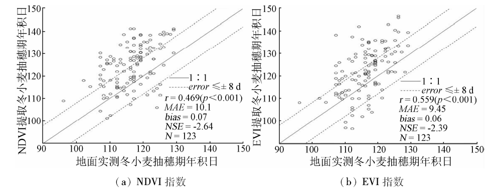
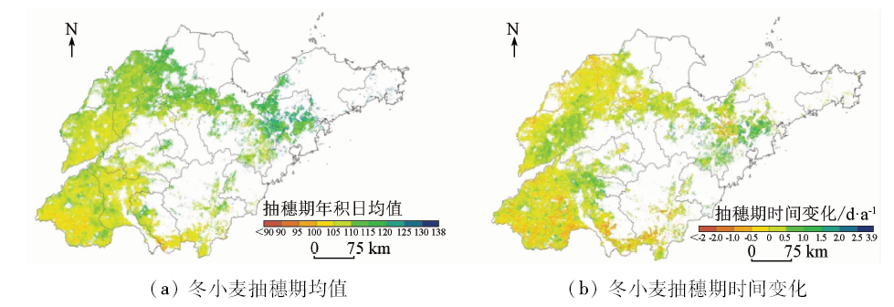
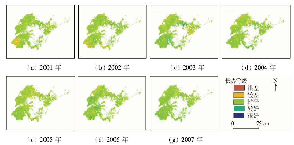
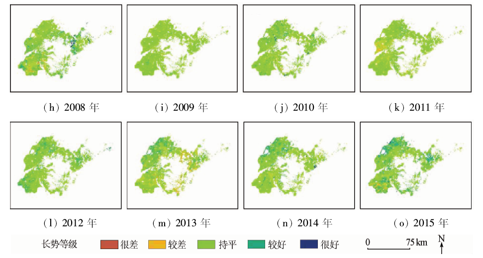
Abstract Crop growth condition monitoring is one of the key contents of crop monitoring. The growth condition of different periods is obviously different especially in a large region because of phenology. In order to improve the accuracy of the research on crop monitoring in the large region and long time series, the authors extracted heading dates of winter wheat in Shandong Province from 2001 to 2015 based on MOD09A1 datasets and then analyzed the spatio-temporal changes of the condition during the heading period of winter wheat. The main conclusions are as follows: ① Heading dates from EVI have a better consistency with ground observation data than results of NDVI. ② Heading stage is mainly concentrated in mid-April to late-April and gradually postponed from south to north, and so is the situation from west to east. ③ Compared with other four indexes, PI_NDVI gets a better resultant index for monitoring the actual growth conditions of winter wheat in the study area. ④ Founded on the results of PI_NDVI, irrigation condition of winter wheat during the heading stage was on the rise from 2001 to 2015. However, interannual fluctuation was obvious. Conditions of winter wheat exhibited an obvious difference in different areas of the same year. However, the growing conditions are consistent in most of the study region, close to the average level of 15 years. The results in this paper are concordant with the records of situ measurement and previous researches in the same area, and this indicates that the research thinking in this paper can provide certain references for the study of crop condition using remote sensing.
|
| Keywords
phenology
crop condition
remote sensing
winter wheat
|
|
|
|
Issue Date: 30 May 2018
|
|
|
| [1] |
蒙继华, 杜鑫, 张淼 , 等. 物候信息在大范围作物长势遥感监测中的应用[J]. 遥感技术与应用, 2014,29(2):278-285.
doi: 10.11873/j.issn.1004-0323.2014.2.0278
url: http://www.cqvip.com/QK/96858A/201402/89717483504849524850484953.html
|
| [1] |
Meng J H, Du X, Zhang M , et al. Integrating crop phenophase information in large-area crop condition evaluation with remote sensing[J]. Remote Sensing Technology and Application, 2014,29(2):278-285.
|
| [2] |
吴炳方, 蒙继华, 李强子 . 国外农情遥感监测系统现状与启示[J]. 地球科学进展, 2010,25(10):1003-1012.
doi: 10.11867/j.issn.1001-8166.2010.10.1003
url: http://d.wanfangdata.com.cn/Periodical/dqkxjz201010001
|
| [2] |
Wu B F, Meng J H, Li Q Z . Review of overseas crop monitoring systems with remote sensing[J]. Advances in Earth Science, 2010,25(10):1003-1012.
|
| [3] |
赵虎, 杨正伟, 李霖 , 等. 作物长势遥感监测指标的改进与比较分析[J]. 农业工程学报, 2011,27(1):243-249.
doi: 10.3969/j.issn.1002-6819.2011.01.039
url: http://www.cqvip.com/QK/71135X/201107/36780616.html
|
| [3] |
Zhao H, Yang Z W, Li L , et al. Improvement and comparative analysis of indices of crop growth condition monitoring by remote sensing[J]. Transactions of the Chinese Society of Agricultaual Engineering, 2011,27(1):243-249.
|
| [4] |
Guindin-Garcia N, Gitelson A A, Arkebauer T J , et al. An evaluation of MODIS 8- and 16-day composite products for monitoring maize green leaf area index[J]. Agricultural and Forest Meteorology, 2012,161:15-25.
doi: 10.1016/j.agrformet.2012.03.012
url: http://linkinghub.elsevier.com/retrieve/pii/S0168192312001219
|
| [5] |
黄青, 唐华俊, 周清波 , 等. 东北地区主要作物种植结构遥感提取及长势监测[J]. 农业工程学报, 2010,26(9):218-223.
|
| [5] |
Huang Q, Tang H J, Zhou Q B , et al. Remote-sensing based monitoring of planting structure and growth condition of major crops in Northeast China[J]. Transactions of the Chinese Society of Agricultaual Engineering, 2010,26(9):218-223.
|
| [6] |
邹文涛, 吴炳方, 张淼 , 等. 农作物长势综合监测——以印度为例[J]. 遥感学报, 2015,19(4):539-549.
doi: 10.11834/jrs.20154137
url: http://d.wanfangdata.com.cn/Periodical/ygxb201504001
|
| [6] |
Zou W T, Wu B F, Zhang M , et al. Synthetic method for crop condition analysis:A case study in India[J]. Journal of Remote Sensing, 2015,19(4):539-549.
|
| [7] |
Esquerdo J C D M,Zullo Júnior J,Antunes J F G .Use of NDVI/AVHRR time-series profiles for soybean crop monitoring in Brazil[J]. International Journal of Remote Sensing, 2011,32(13):3711-3727.
doi: 10.1080/01431161003764112
url: http://www.tandfonline.com/doi/abs/10.1080/01431161003764112
|
| [8] |
Duveiller G, López-Lozano R, Baruth B . Enhanced processing of 1-km spatial resolution fAPAR time series for sugarcane yield forecasting and monitoring[J]. Remote Sensing, 2013,5(3):1091-1116.
doi: 10.3390/rs5031091
url: http://www.mdpi.com/2072-4292/5/3/1091
|
| [9] |
Becker-Reshef B, Vermote E, Lindeman M , et al. A generalized regression-based model for forecasting winter wheat yields in Kansas and Ukraine using MODIS data[J]. Remote Sensing of Environment, 2010,114(6):1312-1323.
doi: 10.1016/j.rse.2010.01.010
url: http://linkinghub.elsevier.com/retrieve/pii/S0034425710000325
|
| [10] |
Chen J, Jonsson P, Tamura M , et al. A simple method for reconstructing a high-quality NDVI time-series data set based on the Savitzky-Golay filter[J]. Remote Sensing of Environment, 2004,91(3/4):332-344.
doi: 10.1016/j.rse.2004.03.014
url: http://linkinghub.elsevier.com/retrieve/pii/S003442570400080X
|
| [11] |
吴文斌, 杨鹏, 唐华俊 , 等. 两种NDVI时间序列数据拟合方法比较[J]. 农业工程学报, 2009,25(11):183-188.
doi: 10.3969/j.issn.1002-6819.2009.11.033
url: http://d.wanfangdata.com.cn/Periodical/nygcxb200911033
|
| [11] |
Wu W B, Yang P, Tang H J , et al. Comparison of two fitting methods of NDVI time series datasets[J]. Transactions of the Chinese Society of Agricultaual Engineering, 2009,25(11):183-188.
|
| [12] |
Rouse Jr J W,Haas R H,Schell J A ,et al.Monitoring vegetation systems in the Great Plains with ERTS [C]//Proceedings of the 3rd Earth Resources Technology Satellite-1 Symposium. College Station,TX,United States:NASA, 1974: 3010-3017.
|
| [13] |
Huete A, Justice C, Liu H . Development of vegetation and soil indices for MODIS-EOS[J]. Remote Sensing of Environment, 1994,49(3):224-234.
doi: 10.1016/0034-4257(94)90018-3
url: http://linkinghub.elsevier.com/retrieve/pii/0034425794900183
|
| [14] |
Hardisky M A, Klemas V, Smart R M . The influence of soil salinity,growth form,and leaf moisture on the spectral radiance of Spartina alterniflora canopies[J]. Photogrammetric Engineering and Remote Sensing, 1983,49(1):77-83.
url: http://www.researchgate.net/publication/235335727_The_influence_of_soil_salinity_growth_form_and_leaf_moisture_on_the_spectral_radiance_of_Spartina_alterniflora_canopies
|
| [15] |
Gonsamo A, Chen J M .Continuous observation of leaf area index at Fluxnet-Canada sites[J].Agricultural and Forest Meteorology, 2014, 189-190:168-174.
doi: 10.1016/j.agrformet.2014.01.016
url: http://linkinghub.elsevier.com/retrieve/pii/S0168192314000252
|
| [16] |
Liu H Q, Huete A . A feedback based modification of the NDVI to minimize canopy background and atmospheric noise[J]. IEEE Transactions on Geoscience and Remote Sensing, 1995,33(2):457-465.
doi: 10.1109/36.377946
url: http://ieeexplore.ieee.org/document/377946/
|
| [17] |
陈维英, 肖乾广, 盛永伟 . 距平植被指数在1992年特大干旱监测中的应用[J]. 环境遥感, 1994,9(2):106-112.
|
| [17] |
Chen W Y, Xiao Q G, Sheng Y W.Application of the anomaly vegetation index to monitoring heavy drought in 1992[J]. Remote Sensing of Environment China, 1994,9(2):106-112.
|
| [18] |
肖伟中 . 小麦长势与产量信息空间变异性及相关性研究[D]. 镇江:江苏大学, 2009.
|
| [18] |
Xiao W Z . Research on Spatial Variability and Relationships of Wheat Growth and Yield[D]. Zhenjiang:Jiangsu University, 2009.
|
| [19] |
耿勃, 张飒 . 2003 年冬季(2003年12月—2004年2月)山东天气评述[J]. 山东气象, 2004,24(1):48-50.
|
| [19] |
Geng B, Zhang S .Weather review of the winter 2003(Dec.2003-Feb.2004) in Shandong Province[J]. Journal of Shandong Meteorology, 2004,24(1):48-50.
|
| [20] |
韩永清, 刘畅, 王娜 , 等. 2013 年冬季(2013年12月—2014年2月)山东天气评述[J]. 山东气象, 2014,34(1):77-79.
doi: 10.3969/j.issn.1005-0582.2014.01.017
url: http://d.wanfangdata.com.cn/Periodical/sdqx201401017
|
| [20] |
Han Y Q, Liu C, Wang N , et al.A review on the weather of Shandong in the winter of 2013(December,2013—February,2014)[J]. Journal of Shandong Meteorology, 2014,34(1):77-79.
|
| [21] |
杨丽萍, 隋学艳, 杨洁 , 等. 山东省春季土壤墒情遥感监测模型构建[J].山东农业科学, 2009(5):17-20.
|
| [21] |
Yang L P, Sui X Y, Yang J , et al. Construction of remote sensing monitoring model for spring soil moisture in Shandong Province[J].Shandong Agricultural Sciences, 2009(5):17-20.
|
| [22] |
刘畅, 王娜, 孟祥新 . 2014 年春季(2014年3—5月)山东天气评述[J]. 山东气象, 2014,34(2):62-64.
|
| [22] |
Liu C, Wang N, Meng X X .A review on the weather of Shandong in the spring of 2014 ( from March to May,2014)[J]. Journal of Shandong Meteorology, 2014,34(2):62-64.
|
| [23] |
段海霞, 王素萍, 冯建英 . 2014 年全国干旱状况及其影响与成因[J]. 干旱气象, 2015,33(2):349-360.
|
| [23] |
Duan H X, Wang S P, Feng J Y.Drought events and its influence in 2014 in China[J]. Journal of Arid Meteorology, 2015,33(2):349-360.
|
|
Viewed |
|
|
|
Full text
|
|
|
|
|
Abstract
|
|
|
|
|
Cited |
|
|
|
|
| |
Shared |
|
|
|
|
| |
Discussed |
|
|
|
|
 2018,
Vol. 30
2018,
Vol. 30