|
|
 |
|

|
|
|
Winter wheat planting area identification and extraction based on image segmentation and NDVI time series curve classification model |
Biqing WANG1, Wenquan HAN1,2( ), Chi XU1,3 ), Chi XU1,3 |
1. Nanjing Surveying and Mapping Research Institute Co., Ltd., Nanjing 210019, China
2. School of Transportation, Southeast University, Nanjing 210096, China
3. College of Earth Sciences and Engineering, Hohai University, Nanjing 211100, China |
|
|
|
|
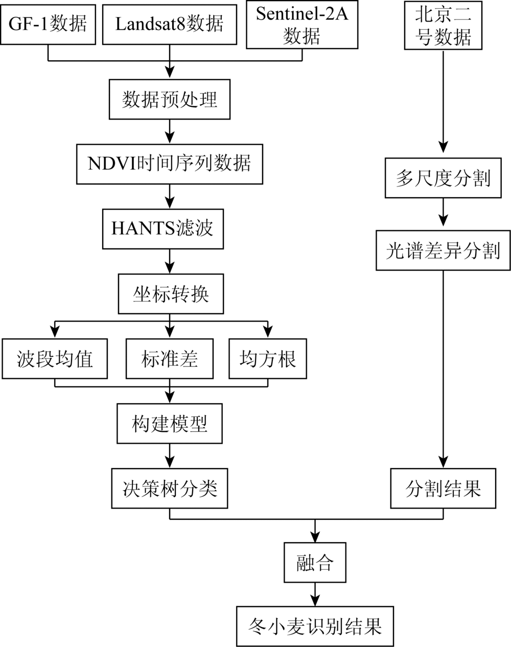
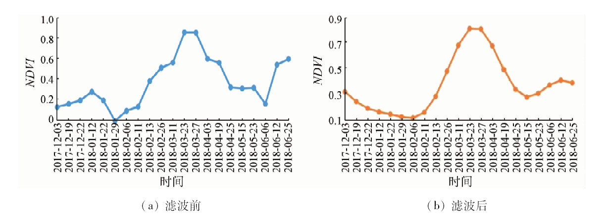
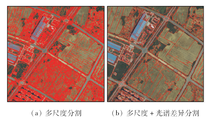
Abstract For the purpose of automatically obtaining a large area of winter wheat planting area, phenological information in medium spatial resolution remote sensing images based on time series curves is usually used to identify and extract. However, in actual engineering projects, if phenological information is used only, the accuracy is low. Therefore, a method based on time series curve data classification model and image segmentation is proposed for winter wheat identification. Firstly, the normalized difference vegetation index (NDVI) time series curve of multi-source data is constructed, and the NDVI time series data are smoothed and denoised by harmonic analysis of time series (HANTS) method. Then, via coordinate transformation of NDVI time series, three parameters of band mean, standard deviation and square mean are obtained to construct a new classification model so as to improve the difference between winter wheat and other crops; finally, by combining segmentation results of spatial resolution data, spatial structure information of the image is used to improve accuracy of feature boundary. Taking Jiangning District of Nanjing as an example, the authors used 21 multi-source images of GF-1, Landsat8 and Sentinel-2A from December 2017 to June 2018, and the final extraction accuracy reached 98.74%, which is better than results of other methods. This method provides agricultural management departments with accurate geographic information data on planting area and distribution of winter wheat.
|
| Keywords
NDVI time series curve
image segmentation
remote sensing classification model
winter wheat extraction
|
|
|
|
Corresponding Authors:
Wenquan HAN
E-mail: lidar_hwq@163.com
|
|
Issue Date: 18 June 2020
|
|
|
| [1] |
Zwart S J, Bastiaanssen W G M, Fraiture C D.WATPRO:A remote sensing based model for mapping water productivity of wheat[J]. Agricultural Water Management, 2010,97(10):1628-1636.
|
| [2] |
李卫国, 蒋楠. 基于面向对象分类的冬小麦种植面积提取[J]. 麦类作学报, 2012,32(4):701-705.
|
| [2] |
Li W G, Jiang N. Extraction of winter wheat planting area by object-oriented classification method[J]. Journal of Triticea Sinica, 2012,32(4):701-705.
|
| [3] |
Jiao X F, Kovacs J M, Shang J L, et al. Object-oriented crop mapping and monitoring using multi-temporal polarimetric RADARSAT-2 data[J]. ISPRS Journal of Photogrammetry and Remote Sensing, 2014,96:38-46.
|
| [4] |
范磊, 程永政, 王来刚, 等. 基于多尺度分割的面向对象分类方法提取冬小麦种植面积[J]. 中国农业资源与区划, 2010,31(6):44-51.
|
| [4] |
Fan L, Cheng Y Z, Wang L G, et al. Estimation of winter wheat planting area using object-oriented method based on multi-scale segmentation[J]. Journal of China Agricultural Resources and Regional Planning, 2010,31(6):44-51.
|
| [5] |
张晶, 占玉林, 李如仁. 高分一号归一化植被指数时间序列用于冬小麦识别[J]. 遥感信息, 2017,32(1):50-56.
|
| [5] |
Zhang J, Zhan Y L, Li R R. Application of GF-1 NDVI time series in winter wheat identification[J]. Remote Sensing Information, 2017,32(1):50-56.
|
| [6] |
侯光雷, 张洪岩, 王野乔, 等. 基于时间序列谐波分析的东北地区耕地资源提取[J]. 自然资源学报, 2010,25(9):1607-1617.
|
| [6] |
Hou G L, Zhang H Y, Wang Y Q, et al. Application of harmonic analysis of time series to extracting the cropland resource in northeast China[J]. Journal of Natural Resources, 2010,25(9):1607-1617.
|
| [7] |
邓刘洋, 沈占锋, 柯映明, 等. 基于地块尺度多时相遥感影像的冬小麦种植面积提取[J]. 农业工程学报, 2018,34(21):157-164.
|
| [7] |
Deng L Y, Shen Z F, Ke Y M, et al. Winter wheat planting area extraction using multi-temporal remote sensing images based on field parcel[J]. Transactions of the Chinese Society of Agricultural Engineering, 2018,34(21):157-164.
|
| [8] |
朱长明, 骆剑承, 沈占锋, 等. 基于地块特征基元与多时相遥感数据的冬小麦播种面积快速提取[J]. 农业工程学报, 2011,27(9):94-99.
|
| [8] |
Zhu C M, Luo J C, Shen Z F, et al. Winter wheat planting area extraction using multi-temporal remote sensing data based on field parcel characteristic[J]. Transactions of the Chinese Society of Agricultural Engineering, 2011,27(9):94-99.
|
| [9] |
林忠辉, 莫兴国. NDVI时间序列谐波分析与地表物候信息获取[J]. 农业工程学报, 2006,22(12):138-144.
|
| [9] |
Lin Z H, Mo X G. Phenologies from harmonics analysis of AVHRR NDVI time series[J]. Transactions of the Chinese Society of Agricultural Engineering, 2006,22(12):138-144.
|
| [10] |
梁守真, 邢前国, 施平, 等. 山东省典型地表覆被NDVI时间序列谐波分析[J]. 生态学杂志, 2011,30(1):59-65.
|
| [10] |
Liang S Z, Xing Q G, Shi P, et al. Harmonic analysis on NDVI time series of typical land covers in Shandong Province[J]. Journal of Ecology, 2011,30(1):59-65.
|
| [11] |
李净, 刘红兵, 李彩云, 等. 基于GIMMS 3g NDVI的近30年中国北部植被生长季始期变化研究[J]. 地理科学, 2017,37(4):620-629.
doi: 10.13249/j.cnki.sgs.2017.04.016
url: http://geoscien.neigae.ac.cn/CN/abstract/abstract39272.shtml
|
| [11] |
Li J, Liu H B, Li C Y, et al. Changes of green-up day of vegetation growing season based on GIMMS 3g NDVI in northern China in recent 30 years[J]. Geographical Science, 2017,37(4):620-629.
|
| [12] |
韩衍欣, 蒙继华. 面向地块的农作物遥感分类研究进展[J]. 国土资源遥感, 2019,31(2):1-9.doi: 10.6046/gtzyyg.2019.02.01.
|
| [12] |
Han Y X, Meng J H. A review of per-field crop classification using remote sensing[J]. Remote Sensing of Land and Resources, 2019,31(2):1-9.doi: 10.6046/gtzyyg.2019.02.01.
|
| [13] |
王碧晴, 王珂, 廖伟逸. 遥感图像分割下的青藏高原湖泊提取[J]. 遥感信息, 2018,33(1):117-122.
|
| [13] |
Wang B Q, Wang K, Liao W Y. Extraction of Qinghai-Tibet Plateau lake based on remote sensing image segmentation[J]. Remote Sensing Information, 2018,33(1):117-122.
|
| [14] |
陈国旭, 李盼盼, 刘盛东, 等. 基于高分一号卫星遥感影像的地表岩性特征提取及三维可视化[J]. 地理与地理信息科学, 2018,34(5):31-36,2.
|
| [14] |
Chen G X, Li P P, Liu S D, et al. Extraction and 3D visualization of surface lithology based on GF-1 satellite images[J]. Geography and Geo-Information Science, 2018,34(5):31-36,2.
|
| [15] |
刘昌振, 舒红, 张志, 等. 基于多尺度分割的高分遥感图像变异函数纹理提取和分类[J]. 国土资源遥感, 2015,27(4):47-53.doi: 10.6046/gtzyyg.2015.04.08.
|
| [15] |
Liu C Z, Shu H, Zhang Z, et al. Variogram texture extraction and classification of high resolution remote sensing images based on multi-resolution segmentation[J]. Remote Sensing for Land and Resources, 2015,27(4):47-53.doi: 10.6046/gtzyyg.2015.04.08.
|
|
Viewed |
|
|
|
Full text
|
|
|
|
|
Abstract
|
|
|
|
|
Cited |
|
|
|
|
| |
Shared |
|
|
|
|
| |
Discussed |
|
|
|
|
 2020,
Vol. 32
2020,
Vol. 32