|
|
|
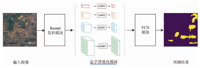
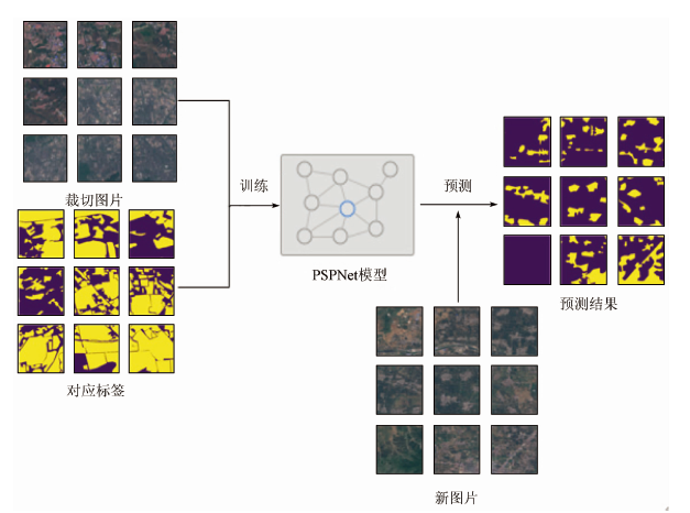
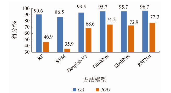
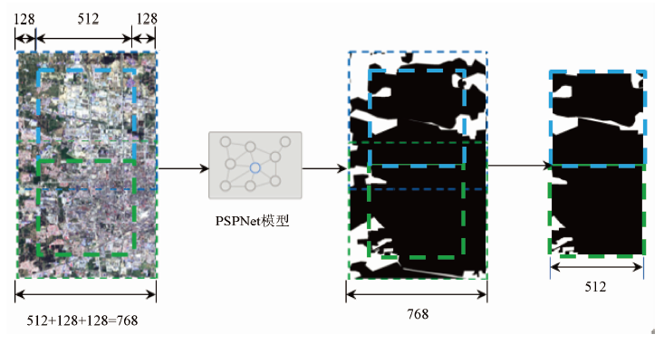
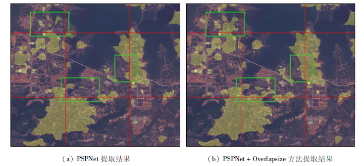
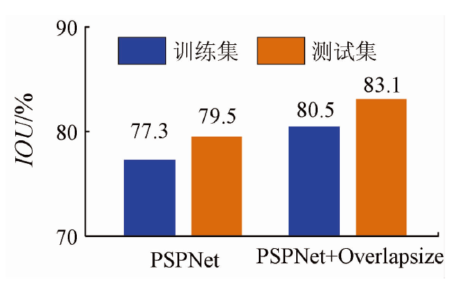
Abstract Using high-resolution satellite remote sensing images to extract the boundary of the built-up area is of great significance for urban expansion monitoring and urban development planning. In order to obtain high-precision and high-resolution built-up area data, this study uses the NDBI index and artificial visual interpretation methods to construct remote sensing image datasets of urban built-up areas and uses traditional machine learning methods and four deep learning methods including PSPNet semantic segmentation network to extract the built-up area of Sentinel-2 images. The training results show that the PSPNet network has the highest accuracy for the built-up area extraction (IOU of the training set is 79.5%). This paper employs Overlapsize method to optimize the extraction results of PSPNet, which further improves the accuracy of the built-up area extraction. The IOU on the training set reaches 80.5%, and the IOU on the test set reaches 83.1%. Compared with the traditional machine learning method, the method of PSPNet + Overlapsize has practical application significance in built-up area extracting.
|
| Keywords
built-up area extraction
deep learning
convolutional neural network
semantic segmentation
PSPNet
Overlapsize
|
|
|
|
Issue Date: 23 December 2020
|
|
|
| [1] |
中华人民共和国建设部. GB/T50280—98城市规划基本术语标准[S]. 工程建设标准全文信息系统, 1999.
|
| [1] |
Ministry of Construction P.R.China. GB/T50280—98 standard for basic terminology of urban planning[S]. Engineering Construction Standard Full-Text Information System, 1999.
|
| [2] |
Masek J G, Lindsay F E, Goward S N. Dynamics of urban growth in the Washington DC metropolitan area,1973—1996,from Landsat observations[J]. International Journal of Remote Sensing, 2000,21(18):3473-3486.
|
| [3] |
刘智丽, 张启斌, 岳德鹏, 等. 基于Sentinel-2A与NPP-VIIRS夜间灯光数据的城市建成区提取[J]. 国土资源遥感, 2019,31(4):227-234.doi: 10.6046/gtzyyg.2019.04.29.
|
| [3] |
Liu Z L, Zhang Q B, Yue D P, et al. Extraction of urban built-up areas based on Sentinel-2A and NPP-VIIRS nighttime light data[J]. Remote Sensing for Land and Resource, 2019,31(4):227-234.doi: 10.6046/gtzyyg.2019.04.29.
|
| [4] |
于清永. 利用中高分辨率影像对城市建成区信息提取的方法研究[D]. 阜新:辽宁工程技术大学, 2016.
|
| [4] |
Yu Q Y. Research on information extraction of urban built-up area by using medium and high resolution images[D]. Fuxin:Liaoning Technical University, 2016.
|
| [5] |
闫晓天. 基于支持向量机及MODIS数据的南昌市城市空间格局演变研究[D]. 南昌:东华理工大学, 2016.
|
| [5] |
Yan X T. Study on evolution of urban spatial pattern of Nanchang base on support vector machine and MODIS data[D]. Nanchang:East China University of Technology, 2016.
|
| [6] |
冯丽英. 基于深度学习技术的高分辨率遥感影像建设用地信息提取研究[D]. 杭州:浙江大学, 2017.
|
| [6] |
Feng L Y. Research on construction land information extraction from high resolution images with deep learning technology[D]. Hangzhou:Zhejiang University, 2017.
|
| [7] |
马凯, 罗泽. 基于卷积神经网络的青海湖区域遥感影像分类[J]. 计算机系统应用, 2018,27(9):137-142.
|
| [7] |
Ma K, Luo Z. Classification of remote sensing images in Qinghai Lake based on convolutional neural network[J]. Computer Systems and Applications, 2018,27(9):137-142.
|
| [8] |
陈磊士, 赵俊三, 董智文, 等. 基于深度学习的滇中城市多光谱影像建设用地信息提取[J]. 软件导刊, 2018,17(11):177-180,186.
|
| [8] |
Chen L S, Zhao J S, Dong Z W, et al. Urban construction land information extraction based on deep learning by multi-spectral remote sensing imagery of Yunnan central urban agglomeration area[J]. Software Guide, 2018,17(11):177-180,186.
|
| [9] |
Zhao H, Shi J, Qi X, et al. Pyramid scene parsing network[C]// Proceedings of the IEEE Conference on Computer Vision and Pattern Recognition.Honolulu:IEEE, 2017:2881-2890.
|
| [10] |
Jonathan L, Evan S, Trevor D. Fully convolutional networks for semantic segmentation[C]// Proceedings of the IEEE Conference on Computer Vision and Pattern Recognition.Boston:IEEE, 2015:3431-3440.
|
| [11] |
He K, Zhang X, Ren S, et al. Deep residual learning for image reco-gnition[C]// Proceedings of the IEEE Conference on Computer Vision and Pattern Recognition.Las Vegas:IEEE, 2016:770-778.
|
| [12] |
Wang T, He P L. The classification algorithm based on the cross entropy rule and new activation function in fuzzy neural network[C]// 2005 International Conference on Machine Learning and Cybernetics.Guangzhou:IEEE, 2005,8:4631-4635.
|
| [13] |
Kingma D P, Ba J. Adam:A method for stochastic optimization[EB/OL]. (2014-12-22)[2019-10-01]. https://arxiv.org/pdf/1412.6980.pdf.
url: https://arxiv.org/pdf/1412.6980.pdf
|
| [14] |
肖莹光. 从部门协调的角度看建成区和规划建设用地的定义和划定[C]// 中国城市规划学会、重庆市人民政府.规划创新:2010中国城市规划年会论文集.中国城市规划学会、重庆市人民政府:中国城市规划学会, 2010:120-124.
|
| [14] |
Xiao Y G. Definition and delineation of built-up areas and planned construction land from the perspective of department coordination[C]// Urban Planning Society of China,Chongqing Municipal Government. Planning and Innovation:Essays of 2010 Annual National Planning Conference.Urban Planning Society of China,Chongqing Municipal Government:Urban Planning Society of China, 2010:120-124.
|
| [15] |
李爱民. 基于遥感影像的城市建成区扩张与用地规模研究[D]. 郑州:解放军信息工程大学, 2009.
|
| [15] |
Li A M. Research on urban built-up area expansion and land use scale based on remote sensing[D]. Zhengzhou:Information Engineering University, 2009.
|
| [16] |
Zha Y, Gao J, Ni S. Use of normalized difference built-up index in automatically mapping urban areas from TM imagery[J]. Remote Sensing, 2003,24(3):583-594.
|
| [17] |
Zhang H, Dana K, Shi J, et al. Context encoding for semantic segmentation[C]// Proceedings of the IEEE Conference on Computer Vision and Pattern Recognition.Salt Lake City:IEEE, 2018:7151-7160.
|
| [18] |
Chen L C, Papandreou G, Schroff F, et al. Rethinking atrous convolution for semantic image segmentation[EB/OL]. (2017-06-17)[2019-06-01]. https://arxiv.org/pdf/1706.05587.pdf.
url: https://arxiv.org/pdf/1706.05587.pdf
|
| [19] |
Zhou L C, Zhang C, Wu M. D-LinkNet:LinkNet with pretrained encoder and dilated convolution for high resolution satellite imagery road extraction[C]// Proceedings of the IEEE Conference on Computer Vision and Pattern Recognition.Salt Lake City:IEEE, 2018:182-186.
|
| [20] |
Zhuang J, Yang J L, Gu L, et al. ShelfNet for fast semantic segmentation[EB/OL]. (2019-09-04)[2019-10-01]. https://arxiv.org/pdf/1811.11254.pdf.
url: https://arxiv.org/pdf/1811.11254.pdf
|
|
Viewed |
|
|
|
Full text
|
|
|
|
|
Abstract
|
|
|
|
|
Cited |
|
|
|
|
| |
Shared |
|
|
|
|
| |
Discussed |
|
|
|
|
 2020,
Vol. 32
2020,
Vol. 32
 ), LIAO Feifan, ZHAO Tong