|
|
|
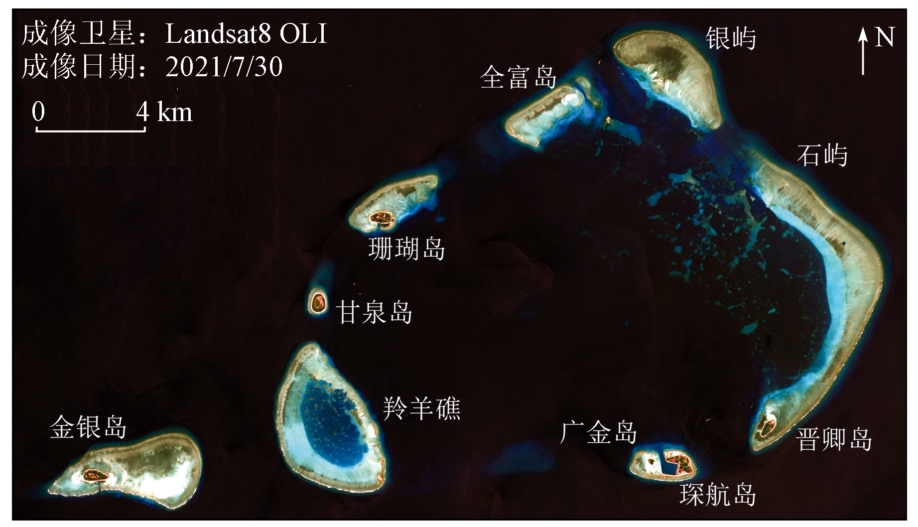
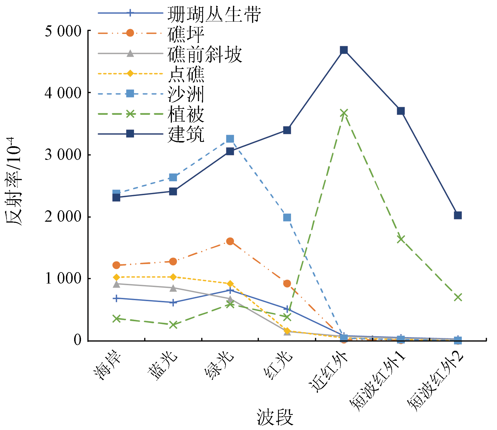
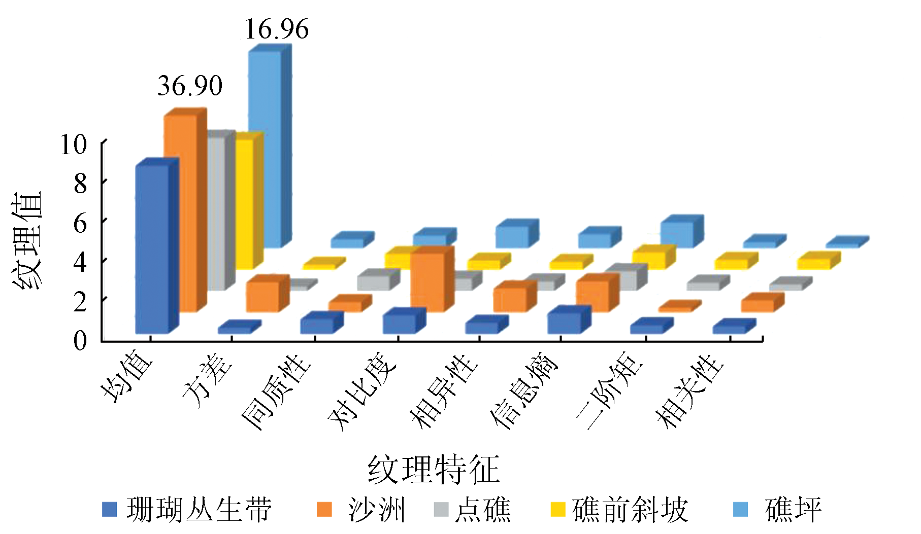
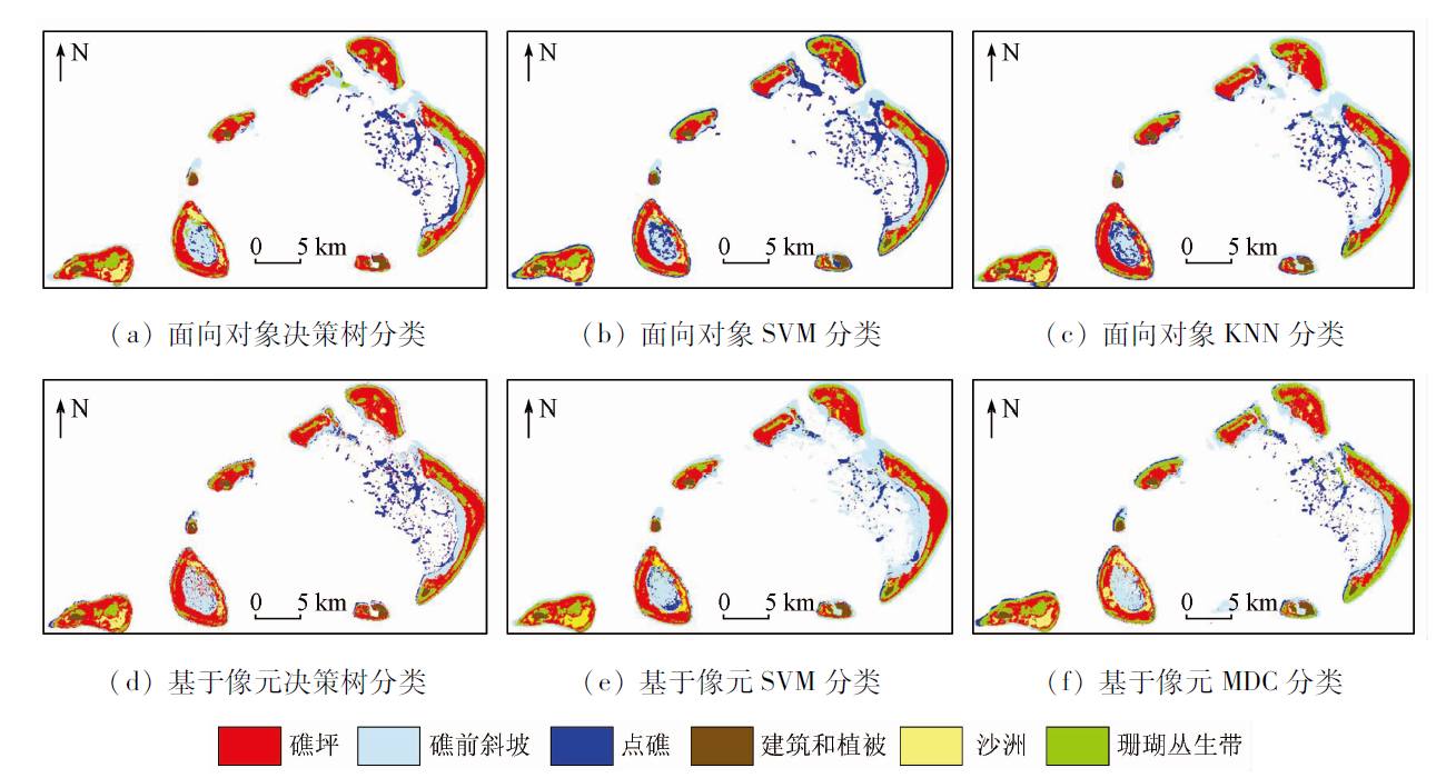
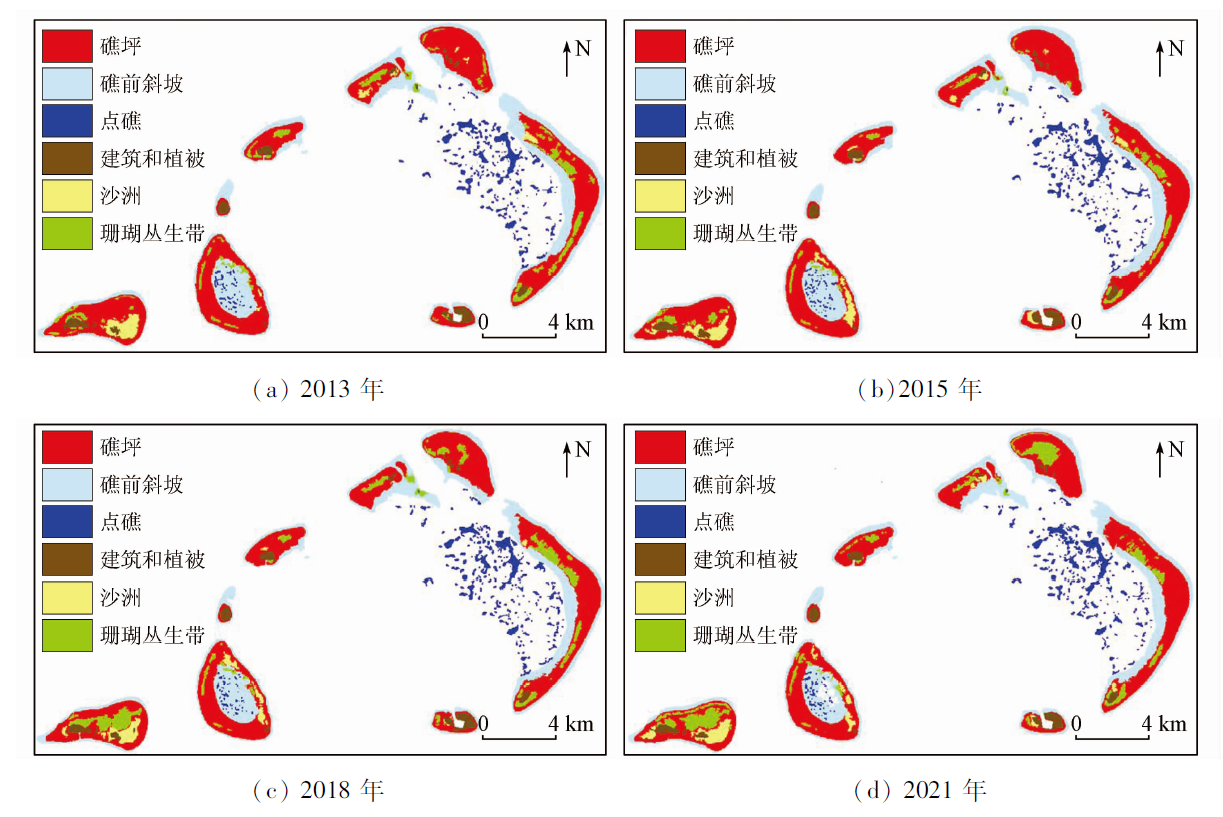
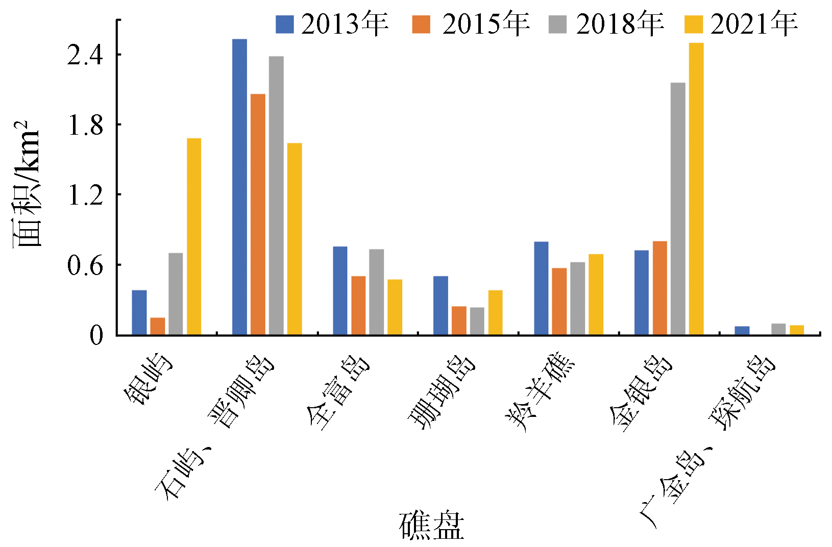
Abstract In view of the drastic changes in the ocean-atmosphere environment, the accurate and efficient identification of coral reef substrate information is essential for the dynamic monitoring of coral reefs. Based on the Landsat8 satellite data of the Yongle Atoll in the Xisha Islands of four periods during 2013—2021, this study proposed a decision tree classification model using spectral and texture indices according to the spectral and texture differences between different substrates. Then, the coral information was extracted using object-oriented and pixel-based classification methods. In addition, the changes in the substrate of the Yongle Atoll were quantitatively analyzed. The results are as follows: ① The results of the object-oriented classification are superior to those of pixel-based classification overall. Moreover, the decision tree classification results yielded Kappa coefficients of 0.63~0.68, with classification accuracy about 7~10 percentage points higher than that of conventional supervised classification; ② Coral thickets are mostly distributed in the central, weakly-hydrodynamic parts of islands and reefs. The corals in the Yinyu Reef and the Jinyin Island exhibit a planar distribution pattern, while those in other islands and reefs mostly show a zonal distribution pattern; ③ The areas of coral thickets and sandbanks in the Yongle Atoll changed significantly overall. Although the total area of coral thickets increased by 1.689 km2, the coral thickets in the Shiyu, Jinqing, Quanfu, and Shanhu islands and the Lingyang reef were severely degraded, with areas decreasing by 0.107~0.892 km2. This study verified that the substrate index established using medium spatial resolution images is reliable and can be applied to remote sensing information extraction of corals. Therefore, this study will provide technical support for the investigation and scientific management of coral reef resources.
|
| Keywords
remote sensing
Yongle Atoll
spectral characteristics
decision tree
object-oriented classification
|
|
|
|
Issue Date: 07 July 2023
|
|
|
| [1] |
赵美霞, 余克服, 张乔民. 珊瑚礁区的生物多样性及其生态功能[J]. 生态学报, 2006, 26(1):186-194.
|
| [1] |
Zhao M X, Yu K F, Zhang Q M. Review on coral reefs biodiversity and ecological function[J]. Acta Ecologica Sinica, 2006, 26(1):186-194.
|
| [2] |
Couce E, Ridgwell A, Hendy E J. Environmental controls on the global distribution of shallow-water coral reefs[J]. Journal of Biogeography, 2012, 39(8):1508-1523.
doi: 10.1111/jbi.2012.39.issue-8
url: http://doi.wiley.com/10.1111/jbi.2012.39.issue-8
|
| [3] |
余克服. 南海珊瑚礁及其对全新世环境变化的记录与响应[J]. 中国科学:地球科学, 2012, 42(8):1160-1172.
|
| [3] |
Yu K F. Coral reefs in the South China Sea:Their response to and records on past environmental changes[J]. Science China Earth Science, 2012, 42(8):1160-1172.
|
| [4] |
张君珏, 苏奋振, 王雯玥. 南海资源环境地理研究综述[J]. 地理科学进展, 2018, 37(11):1443-1453.
doi: 10.18306/dlkxjz.2018.11.001
|
| [4] |
Zhang J J, Su Z F, Wang W Y. A review of geographical information research on resources and environment of the South China Sea region[J]. Progress in Geography, 2018, 37(11):1443-1453.
doi: 10.18306/dlkxjz.2018.11.001
|
| [5] |
王丽荣, 余克服, 赵焕庭, 等. 南海珊瑚礁经济价值评估[J]. 热带地理, 2014, 34(1):44-49.
|
| [5] |
Wang L R, Yu K F, Zhao H T, et al. Economic valuation of the coral reefs in South China Sea[J]. Tropical Geography, 2014, 34(1):44-49.
|
| [6] |
黄晖. 中国珊瑚礁状况报告(2010— 2019)[M]. 北京: 海洋出版社, 2021:9.
|
| [6] |
Huang H. Status of coral reefs in China(2010— 2019)[M]. Beijing: China Ocean Press, 2021:9.
|
| [7] |
李元超, 陈石泉, 郑新庆, 等. 永兴岛及七连屿造礁石珊瑚近10年变化分析[J]. 海洋学报, 2018, 40(8):97-109.
|
| [7] |
Li Y C, Chen S Q, Zheng X Q, et al. Analysis of the change of hermatypic corals in Yongxing Island and Qilianyu Island in nearly a decade[J]. Haiyang Xuebao, 2018, 40(8):97-109.
|
| [8] |
黄荣永, 余克服, 王英辉, 等. 珊瑚礁遥感研究进展[J]. 遥感学报, 2019, 23(6):1091-1112.
|
| [8] |
Huang R Y, Yu K F, Wang Y H, et al. Progress of the study on coral reef remote sensing[J]. Journal of Remote Sensing, 2019, 23(6):1091-1112.
|
| [9] |
da Silveira C B L Strenzel G M R, Maida M, et al. Coral reef mapping with remote sensing and machine learning:A nurture and nature analysis in marine protected areas[J]. Remote Sensing, 2021, 13(15):2907-2931.
doi: 10.3390/rs13152907
url: https://www.mdpi.com/2072-4292/13/15/2907
|
| [10] |
逄今朝, 任广波, 施祺, 等. 基于底质类型变化监测的2005—2018年西沙永乐群岛珊瑚礁白化分析[J]. 海洋科学, 2021, 45(6):92-106.
|
| [10] |
Pang J Z, Ren G B, Shi Q, et al. Analysis of coral reef bleaching in Yongle Islands of Xisha from 2005 to 2018 based on sediment types change monitoring[J]. Marine Sciences, 2021, 45(6):92-106.
|
| [11] |
左秀玲, 苏奋振, 赵焕庭, 等. 南海珊瑚礁高分辨率遥感地貌分类体系研究[J]. 地理科学进展, 2018, 37(11):1463-1472.
doi: 10.18306/dlkxjz.2018.11.003
|
| [11] |
Zuo X L, Su F Z, Zhao H T, et al. Development of a geomorphic classification scheme for coral reefs in the South China Sea based on high-resolution satellite images[J]. Progress in Geography, 2018, 37(11):1463-1472.
doi: 10.18306/dlkxjz.2018.11.003
|
| [12] |
初庆伟, 张洪群, 吴业炜, 等. Landsat8卫星数据应用探讨[J]. 遥感信息, 2013, 28(4):110-114.
|
| [12] |
Chu Q W, Zhang H Q, Wu Y W, et al. Application research of Landsat8[J]. Remote Sensing Information, 2013, 28(4):110-114.
|
| [13] |
李嘉琪, 白爱娟, 蔡亲波. 西沙群岛和涠洲岛气候变化特征及其与近岸陆地的对比[J]. 热带地理, 2018, 38(1):72-81.
doi: 10.13284/j.cnki.rddl.003003
|
| [13] |
Li J Q, Bai A J, Cai Q B. Climate change characteristics of the Xisha Islands and Weizhou Island in China and the comparison with the coastal land[J]. Tropical Geography, 2018, 38(1):72-81.
|
| [14] |
陶士臣, 张会领, 余克服, 等. 近500年西沙群岛海面温度年际变化的珊瑚记录及其环境意义[J]. 第四纪研究, 2021, 41(2):411-423.
|
| [14] |
Tao S C, Zhang H L, Yu K F, et al. Annual resolution sea surface temperature reconstructed quantitatively by porites coral growth rate in the Xishaqundao Islands during the past five centuries and their environmental significance[J]. Quaternary Sciences, 2021, 41(2):411-423.
|
| [15] |
李晓敏, 马毅, 吕喜玺. 南海珊瑚岛礁遥感分类体系和解译标志[J]. 海洋科学, 2021, 45(5):23-30.
|
| [15] |
Li X M, Ma Y, Lyu X X. Establishing a remote sensing classification system and interpretation marks for the coral islands and reefs in the South China Sea[J]. Marine Sciences, 2021, 45(5):23-30.
|
| [16] |
董娟, 任广波, 胡亚斌, 等. 基于高分辨率遥感的珊瑚礁地貌单元体系构建和分类方法——以8波段Worldview-2影像为例[J]. 热带海洋学报, 2020, 39(4):116-129.
doi: 10.11978/2019100
|
| [16] |
Dong J, Ren G B, Hu Y B, et al. Construction and classification of coral reef geomorphic unit system based on high-resolution remote sensing:Using 8-band Worldview-2 image as an example[J]. Journal of Tropical Oceanography, 2020, 39(4):116-129.
|
| [17] |
Nimalan K, Thanikachalam M, Usha T. Spectral characteristics of coral reef benthic compositions in gulf of Mannar[J]. Journal of Earth System Science, 2021, 130(1):1-7.
doi: 10.1007/s12040-020-01500-2
|
| [18] |
徐京萍, 李方, 孟庆辉, 等. 基于野外实测数据的珊瑚礁不同底质光谱可分性及珊瑚色素影响分析[J]. 光谱学与光谱分析, 2019, 39(8):2462-2469.
|
| [18] |
Xu J P, Li F, Meng Q H, et al. The analysis of spectral separability of different coral reef benthos and the influence of pigments on coral spectra based on in situ data[J]. Spectroscopy and Spectral Analysis, 2019, 39(8):2462-2469.
|
| [19] |
Zeng K, Xu Z, Yang Y, et al. In situ hyperspectral characteristics and the discriminative ability of remote sensing to coral species in the South China Sea[J]. GIScience and Remote Sensing, 2022, 59(1):272-294.
doi: 10.1080/15481603.2022.2026641
url: https://www.tandfonline.com/doi/full/10.1080/15481603.2022.2026641
|
| [20] |
Haralick R M, Shanmugam K, Dinstein I H. Textural features for image classification[J]. IEEE Transactions on Systems,Man,and Cybernetics, 1973, SMC-3(6):610-621.
doi: 10.1109/TSMC.1973.4309314
url: http://ieeexplore.ieee.org/document/4309314/
|
| [21] |
潘琛, 杜培军, 张海荣. 决策树分类法及其在遥感图像处理中的应用[J]. 测绘科学, 2008, 33(1):208-211,253.
|
| [21] |
Pan C, Du P J, Zhang H R. Decision tree classification and its application in processing of remote sensing images[J]. Science of Surveying and Mapping, 2008, 33(1):208-211,253.
|
| [22] |
万佳馨, 任广波, 马毅. 基于WorldView-2和GF-2遥感影像的赵述岛礁坪底质变化研究[J]. 海洋科学, 2019, 43(10):43-54.
|
| [22] |
Wan J X, Ren G B, Ma Y. Study on substrate changes of Zhaoshu reef flat based on WorldView-2 and GF-2 remote sensing images[J]. Marine Sciences, 2019, 43(10):43-54.
|
| [23] |
索琳琳, 蔡玉林, 孙旋, 等. 基于Landsat8数据的西沙群岛珊瑚礁信息提取[J]. 中国科技论文, 2019, 14(3):347-352.
|
| [23] |
Suo L L, Cai Y L, Sun X, et al. Mapping coral reefs at Xisha Islands using Landsat8[J]. China Sciencepaper, 2019, 14(3):347-352.
|
| [24] |
徐涵秋. 利用改进的归一化差异水体指数(MNDWI)提取水体信息的研究[J]. 遥感学报, 2005, 9(5):589-595.
|
| [24] |
Xu H Q. A study on information extraction of water body with the modified normalized difference water Index(MNDWI)[J]. Joural of Remote Sensing, 2005, 9(5):589-595.
|
| [25] |
Curran P J. Multispectral Remote sensing for the estimation of green leaf area index[J]. Philosophical Transactions of the Royal Society of London.Series A,Mathematical and Physical Sciences, 1983, 309(1508):257-270.
|
| [26] |
Drǎguţ L, Tiede D, Levick S R. ESP:A tool to estimate scale parameter for multiresolution image segmentation of remotely sensed data[J]. International Journal of Geographical Information Science, 2010, 24(6):859-871.
doi: 10.1080/13658810903174803
url: http://www.tandfonline.com/doi/abs/10.1080/13658810903174803
|
| [27] |
赵英时. 遥感应用分析原理与方法[M]. 北京: 科学出版社, 2003:191-193.
|
| [27] |
Zhao Y S. Principles and methods of remote sensing application analysis[M]. Beijing: Science Press, 2003:191-193.
|
| [28] |
裴欢, 孙天娇, 王晓妍. 基于Landsat8 OLI影像纹理特征的面向对象土地利用/覆盖分类[J]. 农业工程学报, 2018, 34(2):248-255.
|
| [28] |
Pei H, Sun T J, Wang X Y. Object-oriented land use/cover classification based on texture features of Landsat8 OLI image[J]. Transactions of the Chinese Society of Agricultural Engineering, 2018, 34(2):248-255.
|
| [29] |
Lu C, Liu J, Jia M, et al. Dynamic analysis of mangrove forests based on an optimal segmentation scale model and multi-seasonal images in Quanzhou Bay,China[J]. Remote Sensing, 2018, 10(12):2020-2042.
doi: 10.3390/rs10122020
url: http://www.mdpi.com/2072-4292/10/12/2020
|
| [30] |
Espindola G M, Câmara G, Reis I A, et al. Parameter selection for region-growing image segmentation algorithms using spatial autocorrelation[J]. International Journal of Remote Sensing, 2006, 27(14):3035-3040.
doi: 10.1080/01431160600617194
url: https://www.tandfonline.com/doi/full/10.1080/01431160600617194
|
|
Viewed |
|
|
|
Full text
|
|
|
|
|
Abstract
|
|
|
|
|
Cited |
|
|
|
|
| |
Shared |
|
|
|
|
| |
Discussed |
|
|
|
|
 2023,
Vol. 35
2023,
Vol. 35
 ), WANG Daoru2, ZHAO Liang1(